For Christians visiting this website my most important article is: The Reception of God's Holy Spirit: How the Hebrew Prophets _contradict_ Christianity's Teachings. Please click here.
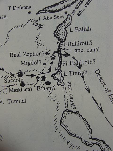
Please click here for my latest map (21 Nov. 2009) showing the site of Israel's "crossing of the Red Sea"
in the Exodus as being at Ras el Ballah (my Baal-zephon)
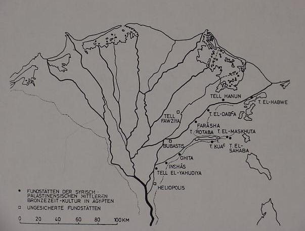
Below is a Map of 16th century B.C. Middle Bronze Age II "Syrian-Palestinian" (Hyksos) sites in the eastern Delta. Note the large overflow lake _west of_ Tell Rotaba (Tell er Retabeh) in Wadi Tumilat. Which today is dry and no longer exists (cf. p. 39. Fig. 34. Manfred Bietak. Avaris, The Capital of the Hyksos, Recent Excavations at Tell el-Daba. London. British Museum Press. 1996).
Could Baal Zephon be the "slight" rises or elevations on either side of the Wadi Tumilat depression? I note a location called Al-Wasifiyah just east of Tell er Retabeh ("Tall Ar Ratabah/Pithom" on the below map) and Tell el Maskhutah (Tall Al Maskhutah), could this preserve Baal Zephon? (cf. p. 132. "Al Qahirah - As Suways (Cairo-Suez)." Britannica Atlas. Encyclopedia Britannica, Inc. Chicago. 1977). A cylinder seal found at Tell ed Daba (Avaris?) of the Hyksos era shows Baal of Zephon standing over two mountains, the sea below as a serpent. The site names, Pi-ha-hiroth, Baal-Zephon, and Yam Suph might harken back to the Hyksos era and the above Middle Bronze II settlements by Asiatics (cf. the above map by Bietak), who perhaps gave these areas these Asitic/Semitic sounding names? To the degree that the Hyksos worshipped Baal of Zephon as a god located near a sea (Yam), the Lake, if visualized as part of the Suez Gulf, would be "apropriate." Thus Ptolemy II's dedication of a temple-estate called Pikerehet may be a"preservation" of an much older Hyksos name for the location which is in the mouth of the Wadi Tumilat depression.
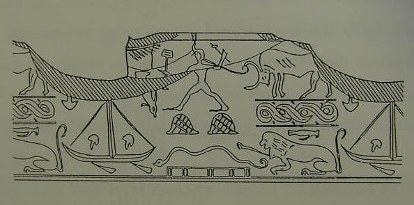
Below, an illustration or drawing of a North Syrian cylinder seal found at Tell ed Daba (the Hyksos capital of Avaris?) of the 13th Dynasty believed to be the Hyksos god Baal Zephon (Saphon) standing over two mountains with weapons in his hands. The serpent below the mountains may personify perhaps the sea called Yam, who, in Ugaritic myths, is defeated in a battle by Baal to be master of the earth (cf. p. 28. Fig. 25. Manfred Bietak.
Avaris, The Capital of the Hyksos, Recent Excavations at Tell el-Daba. London. British Museum Press. 1996
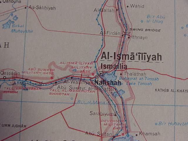
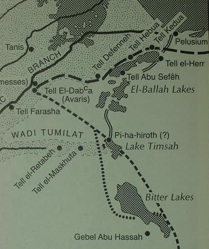
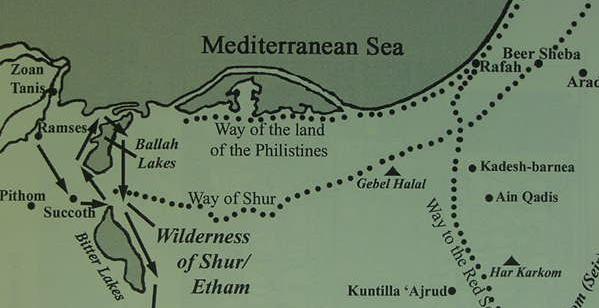
It still remains a "mystery" as to the location of Pi-ha-hiroth and its etymological meaning. Is it a Semitic word or Egyptian? Does it mean "the mouth of the canal" ( Akkadian: pi-hiriti ) or a "farm of the canal" (Egyptian: ha, -so, Naville )? The geography of Wadi Tumilat seems to rule out its being "a gorge" as proposed by Strong's Exhaustive Bible Concordance. Could Tel el Maskhutah be Migdol? A creation of Pharaoh Necho II, famed for stopping the building of a canal to the Red Sea via wadi Tumilat? Could Heroopolis recall Pi-hah-Hiroth? Is the mouth of the canal where it enters Lake Timsah? Is Lake Timsah Yam Suph, the Red Sea? The Darb el Shur from Beersheba ends in the vicinity of lake Timsah. Suggesting the land east of Timsah is the Wilderness of Shur and after crossing Yam Suph Israel is in the wilderness of Shur/Etham according to the Bible. Pre-Suez canal maps (pre 1869) show a land corridor on the south side of Lake Timsah, is this corridor the passage in the midst of Yam Suph, where Israel claims the dry land is bordered by a wall of water on her left and right sides (Exodus 14:21-22)? It still remains a "mystery" as to the location of Pi-ha-hiroth and its etymological meaning. Is it a Semitic word or Egyptian? Does it mean "the mouth of the canal" ( Akkadian: . Could Tel el Maskhutah be Migdol? A creation of Pharaoh Necho II, famed for stopping the building of a canal to the Red Sea via wadi Tumilat? Could Heroopolis recall Pi-hah-Hiroth? Is the mouth of the canal where it enters Lake Timsah? Is Lake Timsah Yam Suph, the Red Sea? The Darb el Shur from Beersheba ends in the vicinity of Lake Timsah, suggesting the land east of Timsah is the Wilderness of Shur, and after crossing Yam Suph, Israel is in the wilderness of Shur/Etham according to the Bible. Pre-Suez canal maps (pre 1869) show a land corridor on the south side of Lake Timsah, is this corridor the passage in the midst of Yam Suph, where Israel claims the dry land is bordered by a wall of water on her left and right sides (Exodus 14:21-22)?
Is Baal-Sephon preserved at the Ballah Lakes and its nearby Saitic/Persian (later Greco-Roman era harbor installations) at Tell Abu Sefeh? Is Pi-ha-hiroth Ptolemy II's temple of Pikerehet mentioned at Tell el Maskhuttah? Is
et-Timsah Etham? Is Shur Abu Suwayr west of Maskhutta? Is the "wilderness of Shur/Etham" the area between Lake Timsah and the Gulf of Suez?
If scholars are correct in assuming that Egyptian Tjeku of the Ramesside Anastasis VI papyrus is Succoth, and if the "fortress of Merneptah _in_ Tjeku" mentioned in the same document is Ramesside Tell er-Retabeh with its Ramesside pottery debris, and that Yam Suph is Lake et-Timsah (famed for its tall reeds), it would appear _to me_ that Ptolemy's Pikheret found _at_ Tell el-Maskhutah is "the strongest contender" for Pi-ha-Hiroth's (Ha-Hiroth of Nu 33:7-8) location. A canal may have existed in Ramesside times from Tell er Retabeh to Lake Timsah and northward to Lake Ballah as proposed by Kitchen and Hoffmeier.
The notion that Pi-ha-hiroth is near Suez (near Roman Clysma) is based on the memoirs of a Christian pilgrimess called variously Egeria or Etheria (ca. 5th/6th century A.D.?) who noted that her guides, who were Christian monks, pointed out the shoals near the Roman fortress of Clysma as the place Israel crossed the Red Sea (cf. pp. 60-61. George E. Gingras. Egeria: Dairy of a Pilgrimage. New York. Newman Press. 1970). The problem? Despite the fact a Ramesside fortress was found under Clysma in the 1960's and excavated by archaeologists the site is some 60 miles from Lake et-Timsah and Tjeku (Succoth?) associated with Wadi Tumilat. Israel's itinerary suggests a campite at the conclusion of a day's journey (variously reckoned from 6 to 20 miles a day), why did the Bible "omit" a number of campsites between Tjeku/Succoth and Clysma/Pi-hahiroth, allowing 20 miles a day for travel? Egeria's diary (pp. 60-62) suggested it was a three day journey for her and her guides from Clysma to Heroopolis which she identified with Pithom (Tell el Maskhutah) in Wadi Tumilat.
I suspect Kitchen's proposal that yam suph (rendered "Red Sea" in English Bibles) encompassed Lakes Ballah, Timsah, the two Bitter Lakes, and the gulfs of Suez and Aqaba is probably correct.
Bibliography:
Manfred Bietak. Avaris, The Capital of the Hyksos, Recent Excavations at Tell el-Daba. London. British Museum Press. 1996.
James K. Hoffmeier. Israel in Egypt, The Evidence for the Authenticity of the Exodus Tradition. New York & Oxford. Oxford University Press. 1996.
James K. Hoffmeier. Ancient Israel in Sinai, The Evidence for the Authenticity of the Wilderness Tradition. New York & Oxford. The Oxford University Press. 2005.
Kenneth A. Kitchen. On the Reliability of the Old Testament. Grand Rapids, Michigan. William B. Eerdmans Publishing Company. 2003.
Edouard Naville. The Store-City ofPithom and the Route of the Exodus. London. Messrs. Trubner & Co. Egypt Exploration Fund. 1885.
Donald B. Redford. "Pi-Hahiroth." p. 371. Vol. 5. David Noel Freedman. Editor. The Anchor Bible Dictionary. New York. Doubleday. 1992.
Strong's Exhaustive Concordance of the Bible, (Hebrew-Chaldee Dictionary # 6367)
02 Jan 2006 Update
Today I stumbled across some highly detailed maps of the Suez Canal area made by French Cartographers about 1882. Fortunately the website hosting these highly detailed maps provides a zooming magnifier to pick up the fine details! By clicking on the following url a variety of antique 19th century maps of various regions of the world are accessible and can be enlarged for your viewing pleasure, cf. http://mapy.vkol.cz/
Based on my study of these maps I have some "new" proposals for Baal-Zephon (Baal of the north?), Yam Suph ("reed sea"?), and Pi-ha-hiroth ("the mouth of the canal"?)
I have finally been able to establish that before the Suez Canal was built in the 1860's that the Mediterranean Sea's tidal actions, mediated somewhat via Lake Menzaleh, caused the Ballah Lakes area to witness tidal rises and falls, that is to say this area witnessed in antiquity alternately innundated and exposed land. The problem? The Mediterranean Sea's tidal action is that of only a couple of centimeters, not enough to affect the water level of the Ballah Inlet appearing on maps from 1797-1860. But, the Ballah Inlet was subject to fluctuating inundations not because of tidal action by the Mediterranean Sea but by the seasonal flooding of the Nile! The connecting point between Lake Maenzaleh and the Ballah Lakes is a narrow opening just west of Qantara. The maps made by the French cartographers accompanying Napoleon Bonoparte's campaigns in Egypt ca. 1797, show that this opening provides a great water volume from Lake Manzaleh to the Ballah Lakes and a depression which almost reaches to Lake Timsah! Detailed maps show this depression, labeled on some maps as el-Kraieh (or Marais de Karash), to be marshlike. Between the el-Kraieh marsh depression and the Ballah Lakes lies a stretch of land possessing six ponds. A headland exists on the westside of the Suez Canal called Ras el Ballah, it lies south of the Ballah Lakes and WNW of the ponds.
Due east of Ras el Ballah (alternately labeled Ras el Moyeh, "Cape of Water") and the six ponds, is a pass at who's east end lies the remains of a canal believed to have been made in antiquity by the Egyptians. This canal is shown on the 1882 map as beginning just east of Ras el Ballah, and continuing south, by passing Lake Timsah, and ending just short of the north shore of the Great Bitter Lake, just to the east of the Suez Canal. That is to say, this ancient canal does not appear to connect to any lake, be it the Great Bitter Lake, Timsah or Ballah. It just comes to an end opposite or east of Ras el Ballah and the six ponds. Could this be a northern "mouth" of an "_unfinished_" canal? If so, then perhaps this is the location of Pi-ha-hiroth, "the mouth of the canal"? Baal Zephon would then be either Ras el Ballah or the Ballah Lakes. Israel is described as having camped at Etham "on the edge of the wilderness", perhaps the vicinity of either Wady Tumilat or Lake et-Timsah, then doubling back on herself to Yam Suph, "the sea of reeds," and camping "in front of" Baal Zephon and Migdol. Thus the crossing of the "reed sea" was at Ras el Ballah, a strong east wind blowing the shallow ford's waters back (2-3 feeet?).
Below, the opening from Lake Menzaleh into the Ballah Lakes drawn ca. 1797 by Napoleon's cartogarphers. Note the numerous islands and the marshlike depression extending south of them almost to Lake Timsah (Description de l'Egypte. Publiee par les ordres de Napoleon Bonoparte. Benedikt Tashen Verlag. Koln [Cologne, Germany] 1994. A paperback [a reprint of the plates accompanying the French work of the early 1800's])
I understand that the fortress of Merneptah mentioned in Papyrus Anastasi VI guarding the "pools of Pr-Tum"
[birkhet Pr-Tum], is Tell er-Retabeh, the birkhet being the great overflow lake _west of_ the Ramesside era fortress. The Ramesside era Papyrus Anastasi VI which mentions of fortress of Pharaoh Merneptah (reigned ca. 1212-1202 B.C.) states these locations are _in_ Tjeku_ (biblical Succoth?).
Excavations in the 1980s of various sites within Wadi Tumilat revealed that only Tell er-Retabeh possessed Ramesside era pottery debris, Tell el-Maskhuttah had no Ramesside pottery debris. Ergo, Naville, who had excavated Tell el-Maskhutah in the 1880's was in error in arguing this site was "Pithom" of his Ramesside Exodus on the basis of Ramesside statues he found there. It is now surmised that perhaps Maskhutta's Ramesside statues were "barged in" on Pharaoh Necho's canal to the Red Sea "to adorn" his new port (Tell el-Maskhutah). The pottery debris at Maskhutah was Hyksos (a few tombs found of this era), then an occupation gap, then Saitic pottery debris ca. 610 B.C. of Necho, then Persian, Ptolemaic and Roman pottery debris.
I understand that Genesis-Kings was composed ca. 560 B.C. in the Exile by one author, but that he combined earlier compositions and traditions into his national history. Professor Holladay who excavated Maskhuttah thought it _was Pithom_ and that this site was a "marker" that the Exodus story was a very late creation, after the time of Necho's building of Pithom/Maskhutah. Others disagree and suggest that the Ramesside pottery debris at Retabeh suggests that this site is Pithom. Professor Donald B. Redford has suggested that the expulsion of the Hyksos in the mid-16th century B.C. may be what the Exodus traditions are recalling. If he's right, then perhaps the Hyksos tombs found at Maskhuttah are witness to the site being called Pi-ha-hiroth by the Asiatics or Semites dwelling there?
Pi-ha-hiroth, rendered "mouth of the Gorges" (Strong's Exhaustive Concordance of the Bible, # 6367) might be the east mouth of Wai Tumilat. I now (22 Jan 2005) _withdraw_ this proposal. I have learned from a recent traveler to the Wadi Tumilat and Lake Timsah areas that the physical geography is NOT that of a "gorge" but rather a "slight depression." This suggests to me that Strong is probably wrong and that Professor K. A. Kitchen's understanding that Pi-ha-hiroth may be referring to the "mouth of the canal" (an irrigation canal called a kharru) is probably correct. Two irrigation canals do traverse the length of Wadi Tumilat from Lake Timsah to the Nile Delta.
A great plain exists between the mouth of the Wadi Tumilat flanked by the sites of el Maskhutah and el Shaba, and Lake Timsah. Perhaps the "hundred-thousands" of Israel were envisoned as assembled here west of Lake Timsah? I understand that Shur (Hebrew shuwr) is preserved at Abu Suwayr/Suweir, a site on the north side of the Wadi Tumilat depression and east of the Ramesside fortress at Tell er Retabeh. Arabic traditions have their "Darb es-Shur" beginning in the Negev at ending at Wadi Tumilat in the vicinity of Ismailia and Lake Timsah. The "wilderness of Etham/Shur" is, for me, the Isthmus of Suez from Lake Timsah to the Gulf of Suez (some 60 miles or a three days journey allowing 20 miles a day).
Naville's (1880's) close-up map of Wadi Tumilat better shows "the elevations" which extend almost to the shores of Lake Timsah.
To the degree that the above map by Bietak shows Hyksos settlements (Maskhutah and Sahaba) near the eastern mouth of Wadi Tumilat, perhaps the presence of Asiatics here in the 16th century B.C. accounts for the Semitic terms found in the bible, terms like Baal Zephon, Migdol, Yam Suph, and Pi-ha-Hiroth (assuming that they are not Egyptian)? A cylinder seal has been found at Tell ed Daba of the Hyksos storm god, Baal Zephon standing over two mountains and a snake below them perhaps representing the sea, or Yam, whom he defeated in the Ugaritic myths. A ship also appears on the seal. Did the Hyksos see the two "slight" elevations flanking the eastern mouth of the Wadi Tumilat depression as being Baal Zephon's two "mountains"? Was the nearby Lake Timsah Baal's "Yam"?
At Tell el Maskhutah Edouard Naville found a stele erected by Ptolemy II dedicating a Temple to Tum, the god of Succoth (Egyptian Tjeku), the temple was called Pikerehet, which Naville suspected preserved the Exodus' Pi-ha-hiroth, pronounced Pi-ha-kheeroth. Did the Egyptians come to transform Semitic Pi-ha-Hiroth pronounced pi-ha-khiyroth) into Pikerehet? Or did the Hyksos transform Pikerehet into Pi-ha-hiroth?
Naville (1885) argued that Pithom was Tell el-Maskhutah based on inscriptions he found there and that a Ptolemaic era tablet of Ptolemy II which he excavated from that site mentioned a temple of Pikeheret which he associated with the worship of Osiris. He thought Pikerehet might be the Hebrews' Pi-Hahiroth. He accordingly argued that as the worship of Osiris is associated with the Serapeum, that this site was where Pikheret was to be located.
Strong's Exhuastive Concordance. Word Books. Waco, Texas.1977. Hebrew and Chaldee Dictionary, renders Pi-ha-hiroth in Hebrew as Strong number 6367 pi ha-chiyroth, pronounced as pee hah-khee-roth, meaning "mouth of the gorges." Pee hah-khee-roth,seems to me, to be preserved in Ptolemy II's Pikerehet inscription found at Tell el Maskuttah by Naville in 1885.
Naville's translation of the Greek tablet or stela of Ptolemy II which he found at Tell el-Maskhuta:
"(line 7)...under the reign of his divine majesty; when it was reported to him that the abode had been finished for his father Tum, the great god of Succoth; the third day of the month of Athyr, his majesty went himself to Heroopolis, in the presence of his father Tum. Lower Egypt was in rejoicing...the festival of his birth. When his majesty proceeded to the temple of PIKEREHET, he dedicated this temple to his father Tum the great living god of Succoth, in the festival of the god...(line 8) ...His majesty made this fine abode, which was erected by the king of Upper and Lower Egypt, Ptolemy, to his father Tum. There was no fine abode like this in the time of the kings of Upper and Lower Egypt..." (p. 17. Edouard Naville. The Store City of Pithom and the Route of the Exodus. 1885. London. Egypt Exploration Fund)
"(line 25)...The account of all the taxes which his majesty has given as revenues to the two divisions of Egypt, on the income of each year...of gold. His majesty gave 150,000 argenei. The account of all the taxes which his majesty has given as revenues to PIKEREHET, and taxes due by the houses of the city and taxes due by the inhabitants (line 27) as income of each year 950 argentei..." (p. 19. Edouard Naville. The Store City of Pithom and the Route of the Exodus. 1885. London. Egypt Exploration Fund)
Naville:
"Let us now try to identify Pi-Hahiroth. At first sight I was struck by the likeness in the sound of the Hebrew word
PI-HAHIROTH with the PIKEHERET or PIKEREHET, which we have found in the tablet of Philadelphos. At present I do not know of any other Egyptian name which may so be compared to the Hebrew. But we have not yet found the word PIKEREHET on a monument of the time of Rameses II, and it is possible that this sanctuary of Osiris may have been built by Philadelphos. However, in general, the Ptolemies did not innovate; they restored the old worships and enlarged the temples; but they adhered to the local traditions. It is therefore most probable that from a very high antiquity Osiris had a temple at PIKEREHET. We have considered PIKEREHET as being the second sanctuary of Heroopolis, at a short distance from Pi-Tum, but nearer the sea; and there is the following circumstance which makes me think that it is PI-HAHIROTH. In the tablet of Philadelphos there is frequent mention in connection with PIKEREHET, of horses which are brought there, and of cattle given to the sanctuary for its annual income. Now, if we revert to the papyrus Anastasi and to the Shasu of Atuma, we see that they ask to drive their cattle in the pastures which belong to the estate or to the farm of Pharaoh. The Egyptian word ah means a farm where cattle or horses are bred; an estate with livestock upon it. If we look at the passage in Exodus where the route of the Israelites is described, we find there that the Septuagint, who made their translation during the reign of Philadelphos, and after them the Coptic version, instead of mentioning PI-HAHIROTH, have written "before the farm" the exact translation of the Egyptian ha. Thus while the Hebrew gives the proper name of the sanctuary, the Greek speaks of the farm, which we know from the papyrus Anastasi was close by in the land of Succoth, like PIKEREHET.
We now have the landmarks of the camping ground of the Israelites: on the north-west PiHahiroth, PIKEREHET, not very far from Pithom; on the south-east Migdol, near the present Serapeum; in front of them the sea; and opposite, on the Asiatic side, on the same hill like Sheikh Ennedk, Baal Zephon. There, in the space between the Serapeum and Lake Timsah, the sea was narrow, the water had not much depth, and the east wind opened the sea, and the Israelites went through." (p. 26. Edouard Naville. The Store-City of Pithom and the Route of the Exodus. London. Messrs. Trubner & Co. Egypt Exploration Fund. 1885)
Naville thought Pikerehet was near the south west shore of Lake Timsah. However, Ptolemy's text suggests for me that the temple of Pikerehet is _in_ Tell el Maskhutah. Line 25 (cf. above) suggests to me that perhaps Tell el-Maskhutah was Pikerehet and that Naville errs in thinking Maskhutah is Pithom.
I do agree with Naville that Ptolemy's text does suggest that the area about Tell el Maskhutah is the region of Succoth by Ptolemaic times and that the site is also called Heroopolis, called Hero in Roman times (but the Ramesside Papyrus Anastasi VI suggests for me that Tjeku/Succoth is the west end of Wadi Tumilat, west of Tell er-Retbah). Could Pikerehet and the Greek Heroopolis, Latin Hero, be variations of the same word and related to Pi-ha-Hiroth
(Ex 14:2, 9), rendered alternately as Ha-Hiroth (Nu 33:8), perhaps the "farm of Hero [lying in the mouth of wadi Tumilat]"?
Professor Redford (an Egyptologist) on Pi-ha-hiroth:
"A stopping place on the itinerary of the Israelites from Goshen to the wilderness (Ex 14:2, 9; Nu 33:7-8). In Exodus 14:2 the place is reached after "turning back" from Etham, and in verse 9 and Numbers 33:7 it is said to be "in front of" or east of Baal-zephon. Neither of these passages, however, is of much assistance in locating the place, and they seem to betray a flawed knowledge of delta geography. As transcribed the word resembles a Hebraized form of Akkadian origin, pi-hiriti, "the mouth of the canal," which would be an appropriate toponym for the edge of the heavily canalized eastern delta.
No Egyptian toponym of this form has yet been found, the closest approximation being pa-Kherta, a town dedicated to the goddess Tefnut, somewhere on the eastern edge of the delta (El Arish naos, rev., 5th-4th centuries BC), or (the variant of the letter) "the pond of Ta-kherta" (P. Dem. Cairo 31169 iii, no. 18 Ptolemaic). It is is conceivable that these could be garblings of the earlier Akkadian geograhical terms postulated above. Other candidates, such as
Per-Hator ( "House [of the goddess] Hathor"), between Tanis and Bubastis ("Hyksos" to post-Saite attestations), or Pa-Hiret (Ramesside) near Qantir, are disqualified for both linguistic and geographical reasons." ( p. 371. Vol. 5. Donald B. Redford. "Pi-Hahiroth." David Noel Freedman. Editor. The Anchor Bible Dictionary. New York. Doubleday. 1992)
A number of scholars suggest that Pi-ha-hiroth means "mouth of the canal" (canal being a Semitic word, kharru, meaning an irrigation channel or canal). Such an understanding is advanced by Egyptologists like K. A. Kitchen, J. K. Hoffmeier and others. Kitchen has suggested that a canal existed between Lake Timsah and Lake Ballah to the north, he accordingly proposes Pi-ha-Hiroth is at one of these canal sites (pp. 259-261. Kenneth A. Kitchen. On the Reliability of the Old Testament. 2003. William B. Eerdmans Publishing Company. Grand Rapids, Michigan).
Lake Timsah may be Yam Suph, as identified by Egyptologists like James K. Hoffmeier and Kenneth A. Kitchen. Travel guides of Egypt in the 1920's mention the large reeds of Lake Timsah (reed in Egyptian being twfy). Perhaps the "hundred-thousands of Israel" may have been visualized as camped before the eastern mouth of Wadi Tumilat on the plain between it and the lake? Hoffmeier's below map locates Pi-hahiroth as the mouth of a canal opening onto the north shore of Lake Timsah (for the below map, cf. Fig. 2. " Map of the Delta and north Sinai." James K. Hoffmeier. Israel in Egypt, The Evidence for the Authenticity of the Exodus Tradition. New York & Oxford. Oxford University Press. 1996). Note: I once thought the crossing of Yam Suph was at Suez as early Christian traditions located the sea crossing there, but I had to give that notion up as the distance between Succoth (Tjeku in Wadi Tumilat) was over 60 miles, and I could NOT conceive of Israel marching _three days_ from Tjeku/Tumilat to Suez. It made better sense, that the journey from Tjeku/Tell er-Retabeh was only _one day_ or less to Lake Timsah/Yam Suph.
Some might "object" to placing Pi-ha-hiroth, Migdol and Yam Suph to the north of the Ballah Lakes because this route is usually identified by most scholars with the biblical "way of the Philistines" which Israel avoided in her initial departure from Rameses (Ex 13:17).
Below, Professor Kitchen's proposal for the location of Pi-hahiroth, which he understands to be the mouth of a canal on the northside of Lake Timsah or the canal's opening onto Lake Ballah (cf. p. 628, fig. 28. "Route of the Exodus, I: Raamses to the Sinai Desert." Kenneth A. Kitchen. On the Reliability of the Old Testament. Grand Rapids, Michigan. William B. Eerdmans Publishing Co. 2003). He speculates that Migdol is some as yet unidentified Ramesside fortress on the el Gisr ridge (cf. his map). I wonder if Ballah might preserve Baal-[Zephon]? And if Tell Abu Sefeh near Ballah preserves "Zephon"? Naville's find of a stele at Tell el-Maskhutta mentioning a temple of Pikerehet might suggest this site is Pi-ha-hiroth? Would the "dry land" Israel crossed with a "wall of water on either side,"be the dry land between Lakes Ballah and et-Timsah (et-Timsah being Etham)? That is to say the land corridor between Lakes Ballah and
et-Timsah are the "walls of water" Israel pased through? The problem is that recent excavations ((1994) at Abu Sefeh have found no evidence of a New Kingdom Ramesside occupation. It is a Roman site with a ship's harbor. Apparently the Ramesside obelisk of Seti I and a plinth of Rameses II found a century earlier at this site were later additions
(cf. Hoffmeier, p.183, and notes 73-76 on pp. 194-195).
Both Kitchen and Hoffmeier have noted that Yam Suph is identified in the Hebrew Bible with not only the Exodus from Egypt but also with King Solomon's seaport of Ezion Geber in or near Edom on the shore of the Gulf of Aqaba. Kitchen has accordingly proposed that the Hebrews most probably understood Yam Suph to extend from Egypt to Edom, embracing Lakes Ballah and Timsah, the two Bitter lakes south of Timsah, the Gulf of Suez and the Gulf of Aqaba. I suspect he is correct.
Kitchen:
"Etham...It may have been in the vicinity of modern Ismailia." (p. 259. Kitchen)
"The term yam suph is also applied to the Gulf of Suez and to the Gulf of Aqaba, which flank the Sinai peninsula. For the Gulf of Suez, cf. Numbers 33:10-11, south of Etham, Marah and Elim. For the Gulf of Aqaba, cf. Numbers 21:4, also Numbers 14:25, Deuteronomy 1:40, 2:1 and perhaps Jeremiah 49:21, All other allusions are the original yam suph of the Exodus at Pi-Hahiroth. In the case of the two gulfs, we have nothing more than extension of usage. Going from north to south, one passed a series of stretches of often salty water, and on arrival at the area of later Suez, here was another long piece of water, stretching into the hazy distance (as did Menzaleh, up north). So it was simply taken as being yet another installment of the collective yam suph. Across the other side of Sinai, an analogous judgement was made; here was another long body of water stretching out south into the horizon like Menzaleh or that of Suez. Nothing more sophisticated than that need be assumed. Compare the extension of the Greek term "Red Sea" to cover (at one time) the Perso-Arabian Gulf, Arabian Sea, and our present Red Sea. Or the word "Asia," from a small Roman province in what is now Turkey, is now used to cover everything from the Bosporus to Japan." (pp. 262-263. Kitchen)
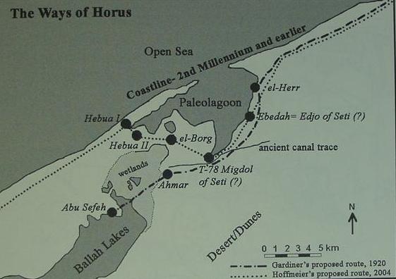
Professor Hoffmeier in his latest book on the Exodus (2005) has modified his earlier above proposal (1997) as to the location of Pi-ha-hiroth as well as its meaning. Instead of it being near the mouth of the canal emptying into the northside of Lake Timsah he now proposes that the crossing of Yam Suph, "the sea of reeds," was from a campsite on a land corridor between the north side of the Ballah Lakes (today consisting of three lakes, cf. the above earlier map) and a now defunct eastern paleo-lagoon to the north of the land corridor (p. 108). For all the new arguments cf. pp. 75-109, "The Location of the Re(e)d Sea." The below is a portion of his map showing the route of the Exodus from Rameses (Qantir) to Kadesh Barnea (Ain el Qudeirat) in the Negev. (cf. Figure 1. "Map of Sinai." [following p. 109]. James K. Hoffmeier. Ancient Israel in Sinai, The Evidence for the Authenticity of the Wilderness Tradition. New York & Oxford. The Oxford University Press. 2005).
Instead of Pi-ha-hiroth meaning "mouth of the canal," he now suggests Hebrew pi may preserve Egyptian p3, and that a location called the p3 hrw, rendered by scholars as either "waters" or alternately "canal" might be what the Hebrew Pi-ha-hiroth is recalling; he prefers to see this word as identfying an eastern frontier canal (pp. 106-107).
He still identifies Succoth with Egyptian Tjeku, the Wadi Tumilat, and Etham with the general vicinity about Lake Timsah. He now argues that Israel "_turned back on herself_" (Ex 14:2) from Etham/Timsah to encamp at the northern perimeter of the Ballah Lakes. He has suggested that Arabic site of Tell Abu Sefeh located on a land corridor north of the Ballah Lakes (cf. above map) might preserve Egyptian p3 twfy, from whence the biblical Yam Suph, which he proposes might be one of the marshy Ballah Lakes (cf. pp. 88-89. Ancient Israel in Sinai,). Migdol, meaning a fortress-tower, is for him, one of several Ramesside era forts (19th/20th Dynasty) guarding the entrance into Egypt near the Ballah Lakes. He notes that the Ramesside papyrus Anastasi III mentions a location called "the waters of Baal" and proposes this might preserve the name Baal of Baal Zaphon, "Baal of the North," of the Exodus account (p. 106). However he does not attempt to identify a specific body of water/s with "the waters of Baal" (His primary concern being in identifying Yam Suph via an association with an Egyptian toponym like p3 twfy). Hoffmeier has noted that excavations at Tell Abu Sefeh reveal it is no older than the Saite/Persian era, but principally a Graeco-Roman site with harbor (p. 92).
FOR MY PART_ I WONDER_might Sefeh preserve Zaphon instead of p3 twfy and Ballah preserve Baal? Is it possible that "the water of Baal" mentioned the Ramesside era Anastasi III papyrus is the Ballah Lake? Alternately, perhaps Zaphon "north" is recalling that Israel at Etham/Timsah (?) "_turns back on herself_, and goes north-northwest (as proposed by Hoffmeier) to the "water of Baal" or the Ballah Lake to entrap the Egyptians? Thus Abu Sefeh (a Persian era site) may not have anything to do with the word Zaphon; Baal (the water of Baal) was merely being located "to the north (zaphon)" of Etham/Timsah? This lake lies due east of Qantir, identified with Pi-Rameses (by some scholars) which had chariots and troops. Israel's turning north-northwest from Timsah/Etham (?) might have been perceived by the Egyptians as her being "lost or entangled in the land" and an easy prey for recapture? If this scenario is plausible, perhaps one of the land corridors between the three Ballah lakes is what Israel crossed through?
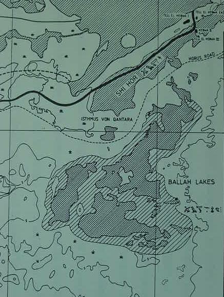
Below, a close-up of the Ballah Lakes area, showing land corridors between the lakes. Of interest here is that the diagonal lines with widespacing indicate that these lakes are/were (?) subject to periodic inundation. I wonder what the source of their occasional "inundation" is? Could this "inundation" at times submerge the land corridors between the lakes? Did Israel cross Yam Suph on one of these land corridors? (for the below map cf. Fig. 1. "Map of the Eastern Delta and a reconstruction of the ancient environment and Nile branches." facing p. 3. Manfred Bietak. Avaris, The Capital of the Hyksos, Recent Excavations at Tell el-Dab'a. London. British Museum Press. 1996)
An expanded version of the above map. Biblical Zoan (Greek Tanis, Arabic San el Hagar) appears at the top edge of the below map. The black cluster to its south is Qantir (Pi-Ramesses?) and Tell ed-Dab'a (Avaris?). The Ballah Lakes are due east of Pi-Ramesses and Avaris (for the below map cf. Fig. 1. "Map of the Eastern Delta and a reconstruction of the ancient environment and Nile branches." facing p. 3. Manfred Bietak. Avaris, The Capital of the Hyksos, Recent Excavations at Tell el-Dab'a. London. British Museum Press. 1996). Note that Bietak has the Mediterranean Sea as "Open Sea" where today one finds Lake Menzaleh and the mud-plain of Pelusium.
Below Map of the area Hoffmeier has proposed that Israel camped at before Pi-ha-hiroth, Migdol and Yam Suph
(Ex 14:2); he identifying the Ballah Lakes as Yam Suph and Migdol possibly being T-78, "migdol of Seti (?). (for the map cf. figure 10 "Map showing "Ways of Horus" routes of Gardiner and Hoffmeier." James K. Hoffmeier. Ancient Israel in Sinai, The Evidence for the Authenticity of the Wilderness Tradition. New York & Oxford. The Oxford University Press. 2005). Note: Hoffmeier's earlier map of this area had a lagoon north of Abu Sefeh, now this lagoon has been replaced by the Mediterranean Sea, gone is the Pelusiac canal near Pelusium (cf. Fig. 2. " Map of the Delta and north Sinai." James K. Hoffmeier. Israel in Egypt, The Evidence for the Authenticity of the Exodus Tradition. New York & Oxford. Oxford University Press. 1996). Note: Hoffmeier, apparently under Bietak's above influence, now has the "Open Sea" in place of the modern Lake Menzaleh and Pelusium mud plain of his earlier maps.
Below, a close-up of the "opening" between Lake Menzaleh and the Ballah Lakes near Qantara. This map reavals that the "opening" between Lake Menzaleh and the Ballah Lakes appearing on the above 1797 map is now "filled in." Perhaps the builders of the Suez Canal in the 1860's are responsible for this "filling-in" of the Ballah inlet? (cf.
V 87.803 Carte hydrographique de l'Basse Egypte et d'une partie de l'Isthme de Suez. 1855, 1882. Paris) By clicking on the following url you can view this map and zoom in and out of its various locations to your heart's content!
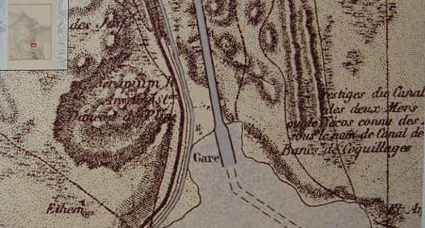
Below, Ras el Ballah (Ras el Moyeh) and the six ponds to its east. Further east lies a pass or break in a ridge through which several tracks pass. One track passes right in front of the northern mouth of the vestiges of an ancient canal. Could this map mark the site of Israel's crossing of Yam Suph? Is the northern mouth of this _perhaps never finished_ canal Pi-ha-hiroth? Does Ras el Ballah preserve Baal-zephon? Are the six ponds residual remnants of the Ballah Lakes, now cut off from the tidal inlet filled-in by the Suez Canal builders?
(cf. V 87.803 Carte hydrographique de l'Basse Egypte et d'une partie de l'Isthme de Suez. 1855, 1882. Paris)
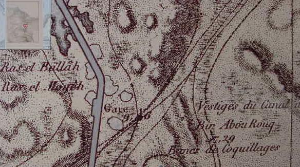
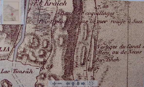
Below, the depression and marshlands of El Kraieh, a little light blue color appears in this region showing some water residue. A ridge south of the depression separates the area from Lake Timsah to its south. A ridge runs north to south starting below and east of Lake Timsah and a "break" in this ridge occurs near the northern mouth of the defunct canal in the above map. This ridge suggests to me that the canal did not debouch into Lake Timsah but passed it on the east side of the Lake. The canal is identified in French as "Vestiges du canal." What appears on the map is two parallel ridge lines of the canal created by the excavated earth like an embankment.
(cf. V 87.803 Carte hydrographique de l'Basse Egypte et d'une partie de l'Isthme de Suez. 1855, 1882. Paris)
Below, the ridge east of Lake Timsah and west of the vestiges of the ancient canal. Note a site called Bir Tiheh near the canal at to top of the map. (cf. V 87.803 Carte hydrographique de l'Basse Egypte et d'une partie de l'Isthme de Suez. 1855, 1882. Paris)
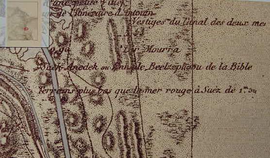
Below, the canal continues to the east of Lake Timsah heading for the Great Bitter Lake. Note: The cartographer has placed on this map sites associated with Israel's crossing of the Red Sea, apparently in the vicinity of Lake Timsah, perhaps under Navillles' 1885 influnce, Sheik Anedek being proposed as "Beel-zephon de la Bible."
(cf. V 87.803 Carte hydrographique de l'Basse Egypte et d'une partie de l'Isthme de Suez. 1855, 1882. Paris)
Below, the ancient canal appears to stop short of entering the Great Bitter Lake, just to the east of the Suez Canal- was this an "unfinished" canal? The Serapeum lies on a ridge just west of the Suez Canal. (cf. V 87.803 Carte hydrographique de l'Basse Egypte et d'une partie de l'Isthme de Suez. 1855, 1882. Paris)
The "newly-found" above maps suggest for me that the Bible's statement that the "sea returned to its strength in the morning" is recalling a tidal event. Several years ago the notion of a tidal action had led me to consider the early Christian traditions of the shoals at the head of the Gulf of Suez near Roman Clysma as the site of the crossing of the sea by Israel. However, I gave up that notion upon accepting that Succoth was most likely Egyptian Tjeku associated with a site in Wadi Tumilat, perhaps Tell er-Retabeh which has a Ramesside fortress. Etham would then be either Wadi Tumilat or Lake Timsah. The distance from Etham/Timsah was 60 miles, a three day journey if traveling on foot at a pace of 20 miles a day (which, by the way, is the daily pace for camel caravans), too great a distance to Yam Suph and the Gulf of Suez and Clysma in _one_ day's journey. I now suspect the three days crossing of the wilderness of Shur or Etham may be the distance from the area between Timsah and Ballah to the Sinai and Bir el-Murr (Marah?) near Ayun Musa (Elim?).
My "problem" after given up a "tidal" Clysma was where is there a body of water subject to tidal flows? Lake Timsah did not appear to fit the bill. It is an overfloow lake from NIle inundations. It dries up the rest of the year into a stagnant Lake. So to the degree it does dry-up periodically, it might qualify as the Yam Suph God dried up? Realizing that the Ballah Lakes in antiquity were linked to the Mediterranean Sea via Lake Menzaleh's outlet caused me to look closer to the area north of Lake Timsah for the Reed-Sea crossing. The mouth of a defunct canal due east of Ras el Ballah and the six ponds (perhaps in antiquity subjected to tidal inundations via the Ballah Lakes) might be another location for the crossing of the Reed Sea event?
Special Note (30 Dec. 2009): I realize now I am in error in seeking a "tidal flow" as the cause of the Red Sea's opening! The Bible says a strong wind blowing from the east parted the waters. This phenomenon is called wind set-down. In January of 1882 a British General, Sir Alexander Tulloch, noted a gale forece east wind blew away Lake Menzaleh's water exposing its bottom for a distance of 7 miles just West of Port Said. The lake was shallow, not more than 4-5 feet deep. If an east wind can blow away 4-5 feet of water at Lake Menzaleh it can blow away the shallow water-ford at Ras el Ballah (Israel's crossing of the Reed Sea being at Ras el Ballah?).
I am not the "first" to propose that a canal in the vicinity of Lakes Timsah and Ballah might be Pi-ha-hiroth, Kenneth A. Kitchen and James K. Hoffmeier have advocated the same too, much earlier than myself.
Below, Kitchen's Pi-ha-hiroth, being the canal associated with Lakes Timsah and Ballah (p. 628. Fig. 28. "Route of the Exodus, Raamses to the Sinai Desert." K. A. Kitchen. On the Reliabilty of the Old Testament. Grand Rapids, Michigan & Cambridge, United Kingdom. William B. Eerdmans Publishing Company. 2003. ISBN 0-8028-4960-1).
Below, Professor Hoffmeier's (1996) proposal, similar to Kitchen's (p. 78. "Map of the Delta and northern Sinai." James K. Hoffmeier. Israel in Egypt, the Evidence for the Authenticity of the Exodus Tradition. New York & Oxford. Oxford University Press. 1996)
Note in 2005 Hoffmeier opted for the "reed sea" crossing to be the northern area of the Ballah Lakes, cf. the above maps (Ancient Israel in Sinai, the Evidence for the Authenticity of the Wilderness Tradition)
The only "problem" I have with the above maps of Pi-ha-hiroth made by Kitchen and Hoffmeier is that they appear to be of the opinion that a canal connected the northern shore of Lake Timsah with the south shore of the Ballah Lakes. My research, above, suggests that these Lakes were _never_ connected! The vestiges of the canal trace place it east of Lake Timsah, "bypassing it". The south end appears to end short of reaching the Great Bitter Lake while the north end stops in the midst of the desert east of Ras el Ballah and its six ponds.
One thing which "troubled me" was if Pi-ha-hiroth is "the mouth of the canal" how can Israel assemble "in front of" or "before" (west of or east of its mouth) if the mouth debouches into a Lake's waters? But if it is an "unfinished" canal like the one east of Ras el Ballah then Israel could take their bearings by this "unfinished" northern mouth and even pass by it on one of the "several tracks" shown passing this canal's northern mouth on the above 1882 map. It just may be that this canal east of Ras el Ballah and Lake Timsah is not Necho's or Darius' canal, it may be a relic from a much earlier period, Ramesside or even earlier (an "aborted" project)?
The below map shows the vestiges of "Pharaoh Necho's canal" (ca. 610 B.C.) leaving the north shore of Lake Timsah and debouching into the south shore of the Ballah Lakes. Perhaps this map, prepared for Sneh, Wessbrod and Perath explains Kitchen's and Hoffmeier's notions? That this canal is actually Necho's is probably only a hunch. I know of no archaeolocal excavations proving it is "his" canal (according to Herodotus he was building a canal from the Nile to the Red Sea _not_ from Lake Timsah north to the Ballah Lakes). The question which arises is, is this the "same" canal appearing on the above 1882 map? If it is, was further research done to establish its linking up with Timsah and Ballah? (cf. fig. 19. "Map showing route of ancient canals in north Sinai, from A. Sneh, T. Wessbrod, and I. Perath, in Scientific American. 63 [1975]; p. 543. James K. Hoffmeier. Ancient Israel in Sinai, The Evidence for the Authenticity of the Wilderness Tradition. New York & Oxford. The Oxford University Press. 2005).
Below, a photo taken by Professor Hoffmeier of "reed-filled" swamps in the area that was part of the el-Ballah lake system near Qantara (for the photo cf. p. 76. fig. 29. James K. Hoffmeier. Israel in Egypt, The Evidence for the Authenticity of the Exodus Tradition. New York & Oxford. Oxford University Press. 1996. ISBN 0-19-513088X paperback)
Hoffmeier has suggested that Israel's crossing of Yam Suph is to the north of the Ballah Lakes area:
"I conclude, therefore, in the light of the new archaeological and paleoenvironmental date presented here, that the geographical setting of Exodus 14 is the area between the north side of the el-Ballah Lake system and the southern tip of the eastern lagoon (i.e., the proposed location of Migdol)." (p.108. "The Location ofthe Re(e)d Sea." James K. Hoffmeier. Ancient Israel in Sinai, The Evidence for the Authenticity of the Wilderness Tradition. New York & Oxford. The Oxford University Press. 2005)
He identifies the Egyptian p3-hr waters with Semitic hr(w) meaning "canal" in the region of Tell el-Borg:
"If p3 hr is the Egyptian name for the East Frontier Canal, then Papyrus Anastasi III demonstrates that this canal was functioning during the New Kingdom. Furthermore, if p3 hr is the feature behind Pi-hahiroth, the the Hebrew pi, instead of being the construct of peh (mouth), would be the writing of the Egyptian article p3. This analysis of Papyrus Anastasi III 2.8-12 indicates that there may be a connection with three of the toponymns found in Exodus 14:2. Baal, p3 hr, and p3 twfy, all associated with bodies of water, we propose to correspond to Baal-Zephon, Pi-hahiroth, and Yam Sup." (p. 107. James K. Hoffmeier. Ancient Israel in Sinai, The Evidence for the Authenticity of the Wilderness Tradition. New York & Oxford. The Oxford University Press. 2005). Hoffmeier suggests Migdol is an Egyptian fortress, either Tell el Borg or some nearby site (p. 107).
The location of fortresses near the northern end of the Ballah Lakes provides Hoffmeier with a possible site for Migdol. My proposal for a crossing near Ras el Ballah has no fortress or Migdol.
03 Jan 2005 Update:
After a "restudy" of Sneh, Wessbrod and Perath's above 1975 map of ancient canal traces in the northern Sinai, it finally dawned on me that the 1882 map was revealing canals NOT appearing on their map.
The 1882 map shows the vestiges of a canal passing from Wadi Tumilat to the _south of_ Lake Timsah, while to the _east of Lake Timsah, ANOTHER canal appears going due north-south, its south end "appears" to be stopping short of the NE shore of the Great Bitter Lake while the north end "appears to end" east of Ras el Ballah. I could be WRONG. Perhaps the eastern canal did connect with the north shore of the Great Bitter Lake? Perhaps the "north end" of this canal east of Ras el Ballah is in fact continuing on north, BYPASSING the Ballah Lakes, and following a DEPRESSION lined by ridges of sea shells (canal depris tips from dredgings?) heading north to the vicinity of Tell er-Her, identified by some with Migdol or Magdolus of the Greco-Roman era.
I "suspect" that the canal trace south of Lake Timsah is probably Pharaoh Necho's, as Herodotus stated he was building a canal to connect the Nile with the Red Sea. The SECOND canal trace east of Lake Timsah and heading due north, bypassing this lake is unaccounted for as to when it was made and by whom. So, it would appear that we have THREE canal traces in the "northern" Sinai (The area encompassing the Great Bitter Lake to the Mediterranean Sea), the one connecting the north shore of Lake Timsah to the Ballah Lakes as presented by Sneh, Wessbrod and Perath (noted by Kitchen and Hoffmeier), and TWO OTHER other canals, one passing south of Lake Timsah and the other passing east of the Lake.
Below a "panorama" of the 1882 map from the Ballah Lakes (at the top of the map) to Lake Timsah showing the vestiges of an ancient canal passing the south side of Lake Timsah from Wadi Tumilat and the canal vestiges east of Lake Timsah ending east of Ras el Ballah which is the ridge southwest of Ballah Lake. The Suez canal (under construction in the 1860's) cuts through the Ballah Lakes and the marsh of el-Kraieh, intersecting the north shore of lake Timsah.
Below, a "close-up" of the vestiges of the ancient canal passing _to the south_ of Lake Timsah from Wady Tumilat; a sweet-water canal _rendered in blue_ was made by the Suez Canal builders to provide drinking water to the workmen, parallels the ancient canal on its north side. To the far right of the map is one of the long-ridges of the canal passing to the east of Lake Timsah. If this canal is not Necho's and _if_ it dates to an earlier age, say the Exodus (?), could its mouth, south of Lake Timsah, be where Israel assembled by Pi-ha-hiroth, "the mouth of the canal"? In this scenario Yam Suph would be Lake Timsah which was famed for its tall reeds lining its shore as late as 1912 in Egyptian Travel guides. I understand the Exodus account was written ca. 560 B.C. in the Exile,_after_ Necho had
(ca. 610 B.C.) "aborted" his canal and founded Heroopolis (Tell el Maskhutah?). Thus a fort or Migdol would be Necho's fortified port at Tell el Maskhutah? That is to say the Exilic narrator may have been describing the crossing of Yam Suph in light of an "Exilic" topography of circa 562-560 B.C. some 50 years after Necho's aborted canal in Wadi Tumilat? After the Exile, the Persians eventually captured Egypt and "completed" Necho's _unfinished_ canal. This unfinished canal's "mouth" would be the envisioned assembly point of Israel? Did Israel "cross" Yam Suph (Lake et-Timsah) via the narrow landbridge on the southside of the lake (two pools of water being shown on the south side of this land bridge on the below map)? The below map shows the "ruines a ancien ville," on the landbridge- has this site been excavated ? Could a Migdol have been sited here? The lake on the south side of the landbridge is fed by an inlet just east of the Suez Canal.
Below, a close-up of the region between the Ballah Lakes and Timsah showing Ras el Ballah (south of Lake Ballah) and the end (?) of the eastern canal opposite the pass in the ridge east of Ras el Ballah and the marsh of el-Kraieh north of Timsah. If this is NOT the end of the eastern canal, is it possible that it headed ENE following the tracks- east of the ridges that are east of the Ballah Lakes?
Below, a "panorama" from Lake Timsah to the Mediterranean Sea, including the Ballah Lakes. I wonder if the ridge extending from Lake Timsah to the vicinity of Tell el Her, identified as Migdol by some, is possibly a continuation of the eastern canal that bypasses Lake Timsah and "appears" to end east of Ras el Ballah? The map does not label anything "vestiges du canal," the last site to get that description is the area east of Ras el Ballah and its six ponds. I realize this proposal flies in the face of Sneh, Wessbrod and Perath's 1975 map showing a canal extending from Lake Timsah to the Ballah Lakes and thence to the vicinity of Tell el Herr, bypassing Tell Sefeh near the north end of the Ballah Lakes.
Below, a close-up of the ridge east of Ras el Ballah and north of the vestiges of the eastern canal. Could this canal have continued on northward _to the east_ of this ridge, to Tell el Herr?
07 Jan 2006 Update:
Below, the crossing of Yam Suph, "the Reed Sea," is identified as a crossing utilizing a land corridor in the midst of the present-day three Ballah Lakes. Baal-zephon is associated with the site of Tell Defeneh (Greek Daphne, biblical Tahpanhes), a fortified site garrisoned by Greek mercenaries serving the Saitic pharaohs of the 8th-6th centuries B.C. Pithom is identified with Egyptian pr-Atum (pr-itm) east of a great overflow lake formed by a branch of the Nile at the west end of Wadi Tumilat. Succoth is associated with Egyptian tj-ku, the east end of Wadi Tumilat. (cf. p. 45. Map no. 47. "Egypt of the Exodus." Yohanan Aharoni & Michael Avi-Yonah [Revised by Anson F. Rainey & Ze'ev Safrai]. The Macmillan Bible Atlas. [Revised 3rd Edition]. New York. Macmillan Publishing Company. [1968, 1977] 1993)
Below, Migdol, associated with the crossing of Yam Suph, is an Egyptian fortress guarding an approach to Egypt north of the Ballah Lakes. (cf. p. 45. Map. No. 48. "The Exodus and Wanderings in the Wilderness." Yohanan Aharoni & Michael Avi-Yonah [Revised by Anson F. Rainey & Ze'ev Safrai]. The Macmillan Bible Atlas. [Revised 3rd Edition]. New York. Macmillan Publishing Company. [1968, 1977] 1993)
Below, A. B. Shafei's _1946_ proposal for the Exodus from Egypt and the crossing of Yam Suph (the Reed Sea). He starts the Exodus at Qantir which he associates with Rameses of the Bible. Succoth is 18 kilometers due east of Qantir, then 20 kilometers takes Israel to Etham and the west shore of one of the Ballah Lakes (10 kilometers = 6 miles); another 24 kilometers takes Israel to the northwestern shore of one of Ballah Lakes, which is then crossed. Shafei locates Pihahiroth with the south shore of this northernmost Ballah Lake, of which there are presently three. (cf. p. 165. "The Route of the Exodus (according to A. B. Shafei)." citing: Aly Bei Shafei. Historical Notes on the Pelusiac Branch, the Red Sea Canal and the Route of the Exodus." Bulletine de la Societe Royale de Geographie d'Egypte. Cairo. Aout 1946. pp. 231-287. in Menashe Har-El. The Sinai Journeys, the Route of the Exodus. San Diego, California. Ridgefield Publshing Company. 1983).
Below, a close-up of Pi-ha-hiroth on the south shore of the northernmost Ballah Lake.
Below, Scolnic's map showing a Pharaonic canal extending north from Lake Timsah to the vicinity of Pelusium north of the Ballah Lakes. His interest is NOT in identifying Pi-ha-hiroth and the crossing of the Red Sea site, but rather the location of Migdol. He reviews several proposals under scholarly consideration and seems to favor Hoffmeier's notion the location is north of the Ballah Lakes (p. 118. for the map cf. p. 95. Fig. 1. map titled "Route of the Exodus." Benjamin Edidin Scolnic. "A New Working Hypothesis for the Identification of Migdol." pp. 91-120. in James K. Hoffmeier & Alan Millard. Editors. The Future of Biblical Archaeology, Reassessing Methodologies and Assumptions. Grand Rapids, Michigan. William B. Eerdmans Publishing Co. 2004). Of interest, is that his map shows no indication of the existence of a canal _to the east of_ Lake Timsah, extending from the Great Bitter Lake to Lake Ballah, as suggested in my "above commentary" on French map made of the Timsah area in 1882. Note: the below map shows the Way to Shur, the Darb el Shur from Beersheba, ending just east of lake Timsah. This suggests the Wilderness of Shur is east of lake Timsah. After Israel crosses Yam Suph, she is in the wilderness of Shur, this suggests Lake Timsah is probably Yam Suph? Timsah is the closest body of water to the western end of the Darb el Shur.
Conclusions (15 Jan 2006):
Pi-ha-hiroth's location still remains a mystery. One of the "problems" it seems to me, is in establishing _A REASONABLE DAILY MILEAGE RATE_ for Israel in her Exodus, _ALLOWING FOR THE CONSTRICTIONS IMPOSED BY FLOCKS AND HERDS_ accompanying her so as to NOT overdrive the animals causing their exhaustion and collapse. Scholarly estimates vary on Israel's rate of march from a low of six miles a day to 23 miles a day.
A "serious problem" in identifying Israel's encampments is that there is _no agreement_ among authorities as to the distance Israel traveled each day between camps.
Professor Hoffmeier noted that several ancient itineraries suggested that caravans consisting of either camels or donkeys could attain a daily rate of 15 to 20 miles, and he suggests that this is Israel's rate of travel in his Exodus campsite proposals. The problem ? Other scholars dispute this. They argue that Bedouin nomads who make their living herding goats or sheep usually do not exceed anywhere from 6 to 10 miles a day so as to not exhaust their flocks. They argue that as Israel is portrayed leaving Egypt with flocks of goats and sheep and herds of cattle, it is impossible for her to achieve the daily rate of a camel or donkey caravan. The problem ? If Israel's daily rate of travel is determined by her flocks, then she could not have gone more than 6 to 10 miles each day between encampments. This is a "very serious" problem ! Why ? Because NO PROPOSAL from any authority (biblical scholar) can get Israel from one proposed campsite to another in one day at a rate of 6 to 10 miles a day !
Hoffmeier, refering to Beitzel's investigations:
"This figure precisely lies between the twenty-four and thirty-two kilometers (fifteen and twenty miles) per day that was reckoned based on comparitive travel distances from ancient texts." (p. 144. James K. Hoffmeier. Ancient Israel in Sinai, The Evidence for the Authenticity of the Wilderness Tradition. Oxford & New York. Oxford University Press. 2005)
Beitzel:
"Itinerary texts from the Mosaic period stipulate that caravans were able to cover no more than about 20-23 miles per day. With the Exodus, however, the size and the background of the group, when combined with the factors of accompanying women and children and flocks and herds (Ex 12:38; 34:3; cf. 17:2; Nu 20:19), eliminate any possibility...The average daily distance maintained by modern bedouin moving from camp to camp is about six miles." (p. 91. Barry J. Beitzel. The Moody Atlas of Bible Lands. Chicago. Moody Press. 1985, 1988)
Bryant G. Wood, a trained archaeologist observes : "A large group of pastoralists moving with their possessions and animals can cover no more than 6 miles in a day, and usually less (Conder 1883: 79; cf. Beitzel 1985: 91). The limiting factor is the animals. When the Israelites left Egypt, they had "large droves of livestock, both flocks and herds" (Ex 13:38). " http://abr.christiananswers.net/jebel_thoughts.html
Professor Har-El prefers a daily rate of travel for Israel of about 6 miles, based on his once having been a shepherd himself. He is critiquing Shafei's 1946 proposal for the Exodus route from Rameses to Yam Suph (emphasis mine in capitals):
"Shafei's map indicates that the Israelites covered 18 km. on the first day of the journey, 26 km. on the second, and 24 km. on the third. This view is entirely untenable for the following reasons: a) Old people, women and children could hardly progress at such a rate...b) Herds with their young cannot cover such long distances without collapsing on the way (I know this from my own experience as a shepherd); c) Such a large mass of people, weighed down by large quantities of baggage and heavily laden with posessions, could not possibly have made such rapid progress. Conder's observation that the Bedouin who move camp travel at _A MAXIMUM OF SIX MILES A DAY_ also provides support to this point of criticism. His estimate refers to small groups of Bedouin who are properly prepared for their move, in contrast to the large numbers of the Israelites who left Egypt in a hurry, without having made preparations for their journey."(p. 167. Menashe Har-El. " Criticism of Shafei's View." The Sinai Journeys, The Route of the Exodus. San Diego, Calfornia. Ridgefield Publishing Company. 1983. [first published in Hebrew 1968, by Am-Oved Publishing Ltd. Tel Aviv])
One individual noted (in an e-mail to me 09 Oct 2005): "Another Archaeologist, Clark Hopkins (of Yale) while directing a dig at Dura-Europas in the Syrian desert, noted that herders were moving 8-10 miles a day in areas where there was not enough pasture to satisfy the small livestock."
How far does one get from Qantir (Rameses?) in 2 days (?) time to Etham? Day One: Rameses to Succoth; Day Two: Succoth to Etham (Nu 33:5-6)? Two days at 6 miles a day is 12 miles, Etham is 12 miles from Qantir (Rameses?)? If the rate of travel is 10 miles a day with herds and flocks, 2 days from Qantir (Rameses?) locates Etham 20 miles away. If the flocks and herds can be driven 20 miles a day in 2 days' time Etham is 40 miles from Qantir (Rameses?). Day Three: Etham to Yam Suph (Pi-ha-hiroth), would be 60 miles from Rameses (Qantir).
To what degree have scholars FACTORED IN "the daily rate of travel" of Israel _with flocks and herds_ in the above proposals for the sites of Succoth, Etham, Pi-ha-hiroth, Migdol, and Yam Suph's crossing?
One of the problems in determining the route of the Exodus is "how many miles a day" was the narrator envisioning? Was it 20 to 25 miles, which could be covered by a camel or donkey caravan or was it 6 to 10 miles a day that nomadic shepherds herding goats would have covered?
If Lake Timsah is Yam Suph because the Way to Shur, the Darb el Shur, ends east of this lake, then Ptolemy II's Pikheret (found at Tell el Maskhuttah in 1885 by Naville) is probably recalling Pi-ha-Hiroth, pronounced
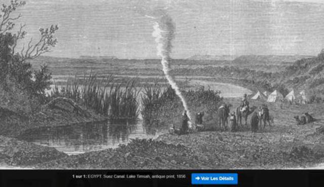
Pi-ha-khee-roth See Strong 6367, Hebrew and Chaldee Dictionary, in James Strong. Strong's Exhaustive Concordance. Waco, Texas. Word Books. 1977) Stong understands the word means "mouth of the gorges" and I note that Lake Timsah is at the end of the Wadi Et-Tumilat defile, which may have been seen as a gorge. Engravings from the 1800s show mountains in the background of Lake Timsah with Arabs in tents on the reed filled shores of Lake Timsah.
The below 1826 map shows a Gebel el Keir west of Lake Temsah, does this preserve Khee-roth? Was Migdol Tel el Maskhuttah, Pharaoh Necho II's port-city on the Red Sea Canal (Greek Heroopolis)?
Below, a map made in 1826 (Paris) showing a land corridor or land-bridge across the middle of Lake Et Timsah, which might be the walls of water on Israel's right and left sides as she crossed Yam Suph (Exodus 14:21-22)? Yam in Hebrew can mean a lake as well as a sea, for instance, the Sea of Galilee is a Lake, the Dead Sea is another Lake. Wikipedia (accessed 09 Sept. 2019), on Lake Timsah, stated: "Most of the lake is marshy and depth rarely exceeds 3 feet (1 metre)." In my opinion, a depth of 3 feet could easily be swept away, exposing lake bottom, or its land corridor in pre Suez Canal maps (pre 1869) via wind-set-down. In January of 1882 an east wind blew away 6 feet of water at Port Said on the Suez Canal, leaving boats docked there on the bottom of Lake Menzalleh, as witnessed by a British General, Sir Alexander Tulloch (1838-1920) in his published Memoir of 1903 (see Alexander Bruce Tulloch. Recollections of 40 Years' Service. London and Edinburgh. pp. 245-246). If wind-set-down can expose a marsh lake's bottom, covered over by 4 to 6 feet of water, the same wind should be able to sweep away 3 feet of water at Lake Timsah.
Note that the land-corridor in the below 1826 map shows no access point for the southern half of Lake Temsah to recieve water from its northern half. This anomaly suggests to me that the southern half may have gotten its water when the annual Nile inundation raised the lake's water levels high enough to submerge the land-corridor, allowing water from the northside of the lake to flow into the southern side of the lake. In this scenario the land-corridor would be submerged under high flood water levels. In this situation, an east wind blowing over the lake could conceivably blow away the shallow water from off the land-corridor, exposing it for Israel to cross on from the west side of the lake to the east side of the lake. Perhaps this is what is being recalled in Exodus 14:22, that God caused dry land to appear, and on the right and left sides of Israel, there was a wall of water: the northern half of the lake being the left side, by Israel's reckoning and the southern side of the lake, or right hand, by Israel's reckoning? After crossing Yam Suph Israel is now in the wilderness of Shur. The Darb el Shur or Way to Shur (see Wooley, The Wilderness of Zin, 1914), beginning at Beersheba, ends in the vicinity of Lake Timsah according to most scholar's maps. Just east of Lake Temsah is Bir Murrah, recalling biblical Marah (the Septuaginta's Merra). But Marah is more probably the Bitter Lakes, Murrat in Arabic as it 3 days from Yam Suph in the Wilderness of Shur, to Marah/Merrah.
Another problem in determining the route of the Exodus is "How reliable is the account?" When it was composed? Some of the sites mentioned in the Pentateuch, the first five books of the Bible (supposedly written by Moses according to some traditions) have been excavated and determined to be no earlier than the late 8th century B.C. like modern Buseira, biblical Bozrah in Edom). This anomaly suggests for some scholars that a narrator circa 562-560 B.C. in the Exile may have thought _in error_ that sites in existence in his day (the 6th century BC) were in existence in Moses' days (the 16th or 15 century B.C.) in which case, limiting a search to these centuries is "foolishness" as sites in existence as late 560 B.C. might be part of the itinerary. The Exilic narrator could have identified sites from different periods of time, the New Stone Age, 6000 B.C. to the Exile of 560 B.C. as making up the Exodus itinerary as no one in antiquity really knew the age of any the ancient tells in Egypt, the Sinai, and Canaan, until Sir Flinders Petre and his successors developed a Pottery Typology to date these locations by.
Please click here for my article on "Exodus Problems" to see why some scholars do not understand the Exodus narratives to have been composed by Moses nor an eyewitness to the Exodus but by an Exilic author circa 560 B.C
Below, an engraving circa the 1850s of Lake Timsah showing tall reeds, the land corridor in the midst of the lake and mountains surrounding the lake, perhaps "the mouth of the gorges" or Pi-ha-Hiroth in Hebrew?