Maps Proposing Possible Sites for Fort Caroline on St. Johns Bluff, Florida, 1564-1565, renamed in 1565 Fort San Mateo by its Spanish conqueror, Pedro Menendez de Aviles, founder of St. Augustine, Florida in 1565.
These maps accompany the research of Walter R. Mattfeld, M.A. Ed.
Orange Park, Florida 32073
.
14 September 2011, Revisions through 14 October 2020
Corrections and comments are welcomed via email contact: wrmattfeld411@gmail.com
Please click here for additional details citing and quoting from eyewitnesses statements of 1564-1565 appearing in French, Spanish and English accounts of the period.
Fort Caroline is certainly "somewhere" between St. Johns Creek on the east and Shipyard Creek and Calypso Island on the west, near the river's bank. This area constitutes today's (2013) St. Johns Bluff on modern maps.
The French would need fresh water to drink and they selected a site that had access to a spring lying on the opposite side of a hill. This suggests today's Spanish Pond was that Spring. However the spring appears as a marsh in other accounts. Heavy hurricane rains could cause Spanish Pond to overflow turning the area into a marsh. The pond may have been called a Spring? There are two ponds on the 1791 map and they appear on maps made in 1898 as well as Satellite views of the area today (2015).
Of note is that in 1858 and 1868, George R. Fairbanks, Vice President of the Florida Historical Society located Fort Caroline west of St. Johns Bluff's promontory. Why west of the promontory? In LeChalleux's escape account he said he had to hang on to bushes on the face of a "mountain's brow," from which ships could be seen at the river's mouth. He was descending the mount to the marshes below. Fairbanks noted this area seemed to be the steep east face of the St. Johns Bluff promontory, ergo, the fort was probably west of it as Le Challeux was fleeing east to the ships. Fairbanks thought that the fort was on the shore of the St. Johns River and that this shore had been eroded away by the river over a period of 300 years and thus the fort was not recoverable. Eyewitness accounts mention an open plain one bow shot (300 yards or 900 feet) in length between the fort and a wooded hilltop, the 1791 and 1856 maps show an open plain and wooded hill west of St. Johns Bluff promontory. Perhaps the fort is there, at the river's edge, the plain being above the fort? The "flatest" area of the Bluff's western slope (from St. Johns Creek to Calypso Island) suitable to be "on a riverbank" is where today's National Park Service replica of the fort is. If it is here, then the French sentinels had to hike daily from this location to the Bluff's highest point, today's parking lot for the Ribault Pillar Monument, to look for ships' sails at the mouth of the river. But the fort could just as well be east of today's National Park Service Museum, as this area is closer to the two ponds and it makes sense the occupants of the fort would want to be as close to a freshwater source as possible. Perhaps the fort is under the buildings appearing on the 1856 Map, but near the river's bank?
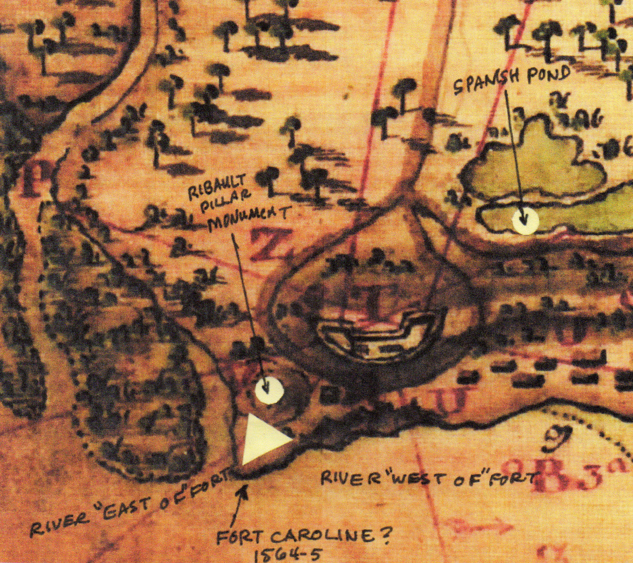
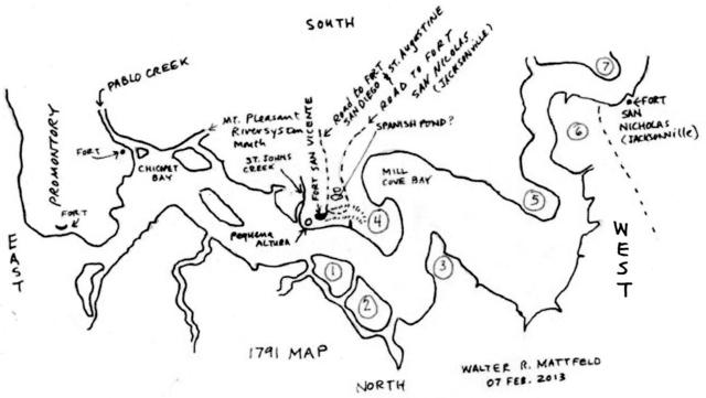
The below map was drawn up by the Spanish at St. Augustine Florida on 24 Dec.1791 of the St. Johns River. I overlaid it with my proposals for the location of the French Huguenot Fort Caroline of 1564-1565. The Spanish account states that the fort is near a high hill or barranca alta (barranca can also translate as
"bluff"), and the fort is bounded on its west by land, the other side being the river. The French sent daily sentinels up to a small hill to watch for ships' sails at the mouth of the May River (today's St. Johns River). The Spanish said the fort was at a location called barranca alta, a "high bluff" or "high hill" on the southwest arm of the river, which I understand is either today's St. Johns Creek, east of the Bluff and west of today's Buck Island, _or_ the southwest arm of the St. Johns River separated from its northern arm by Great Marsh Island? I understand this "small hill" of the French sentinels appears on the below 1791 map and it is the location today (2013) of the Ribault Pillar Monument erected by the National Park Service, a 70 ft. elevation today. Rene Laudonniere said when he saw ships' sails from this small hill he sent one of his men down to the fort to alert them the relief fleet had arrived from France. He said he heard and saw the men shout and leap for joy. Five hundred Spanish soldiers waited the night of 19 September 1565 in a nearby marsh in rain, to cross over a hill and attack the fort on the morning of 20 September with 20 scaling ladders. I understand this marsh to be today's Spanish Pond, which is shown as two ponds on the 1791 map. The hill they crossed over is the hill-ridge extending west (40-50 ft. high) from today's Ribault Pillar Monument elevation (70 feet today). The 1791 map shows a fort with 8 cannons and red lines showing the trajectory of cannon balls. I understand the Spanish may have later moved Fort Caroline, their Fuerte de San Mateo (?), to a higher elevation at a later period as revealed on the below map. At a higher elevation it would be harder for enemies to sneak up behind the fort using the western hill-ridge (40-50 ft. elevation) for cover as the French had done in 1568.
Archaeologists believe that French Charlesfort (1562) exists under a later Spanish Fort, San Felipe at(1567-1578) St. Elena on Parris Island, South Carolina, if they are correct, could Fort Caroline be under this Spanish 1791 fortress (called in this period Fort San Vicente)? The Spanish account of Fort Caroline's fall states that de Aviles sent reconnaissance spies to locate the fort from the marsh they had waited in all night (believed to be Spanish Pond). They crossed over a hill and sighted a house, going further down the hill they then saw the fort nearer the river. This suggests the fort was _not_ atop the hill or they would have seen it and had no need to descend further down the slope to find it, so it is most unlikely that Fort Caroline is atop the hill ridge under the 1791 fortress.
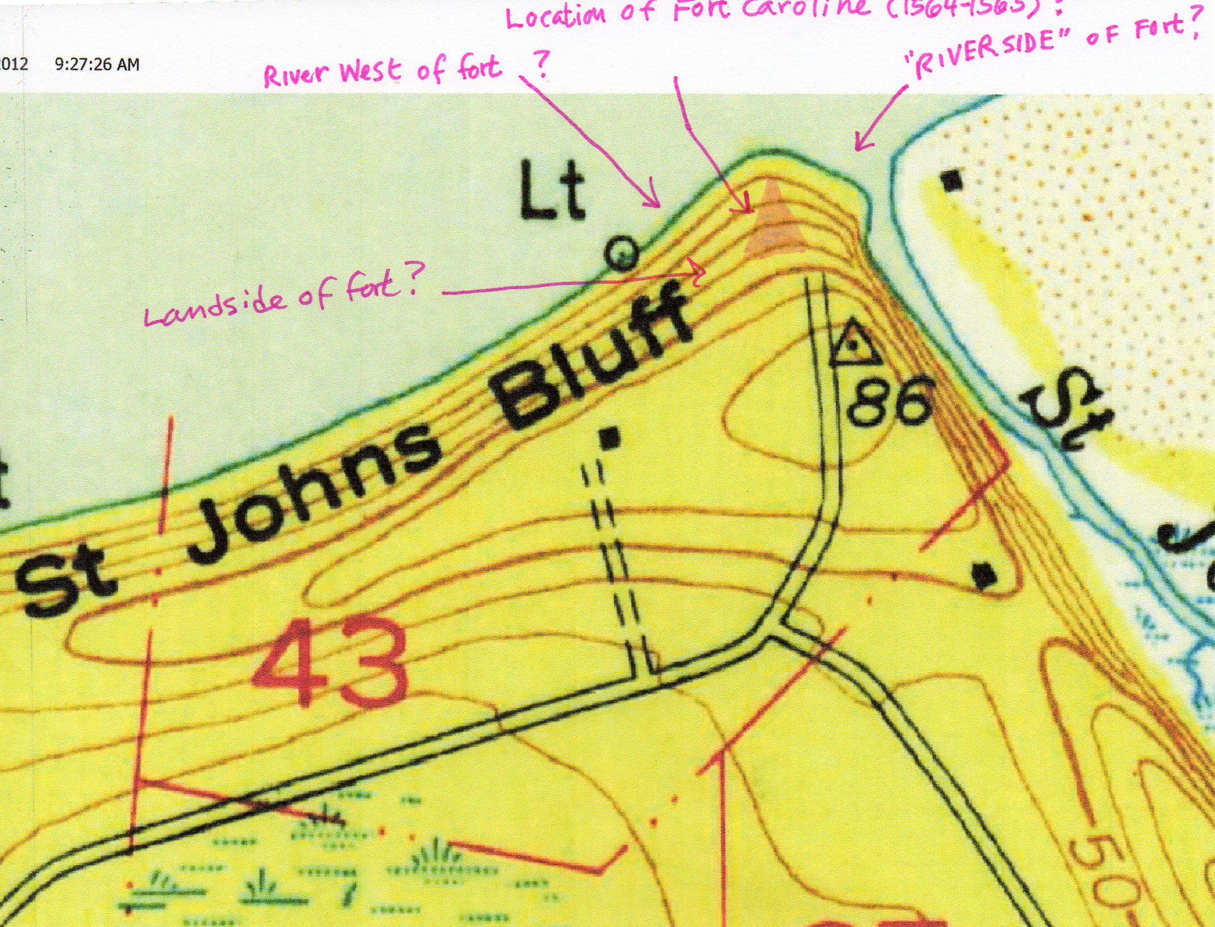
Below, a topographical map of St. Johns Bluff made by the United States Geological Survey, Map titled
Mayport. 1950 1:24,000 scale, I have in pink ink marked off my proposals for features associated with Fort Caroline in the French accounts of 1564-1565. Earlier, I had thought the fort might be at this promontory, I suspect now (20 April 2013) I was wrong, its probably further west of the promontory and at the river's edge above the number 43 on the below map. Today's Ribault Pillar Monument is located near the triangle on the below map marked as 86 (86 feet?). The problem? The map shows the contour line the triangle sits within to be 70 feet, not 80 feet. Thus the elevation could be 76 feet? However, the 1917 Topographical map shows an 80 foot contour line here and no road at this site. Was 86 feet the height in 1917? If so, then 17 feet have been bulldozed away since 1950 to make the road and later parking lot for the Ribault Pillar Monument?
Below, Fairbanks' map showing Fort Caroline at the northern tip of the St. Johns Bluff Promontory, the map says "Supposed site of Ft. Caroine" the dotted line is the road from the bluff and Fort Caroline to St. Augustine (cf. map between pp. 50 and 51 in George R. Fairbanks. The History and Antiquities of St. Augustine, Florida. 1858). This book is available on the internet under Google, free books search engine. Fairbanks opined that the fort had been built a wide sandy shoreline of the bluff which had washed away over 300 years. The fort was built at the base of a wooded hill, on the river May's bank, with a small open plain one bowshot in width between the Fort and woods. This suggests the fort is at the base of the open plain slope of the western hill-ridge, west of St. Johns Bluff promontory, see the 1791 map (above) for this open plain. The below map (1858) suggests St. Johns Bluff is encircled by two creeks, Shipyard on the west and St Johns on the east, perhaps this is being portrayed by streams encircling Fort Caroline on the engraving by LeMoyne (1565)?
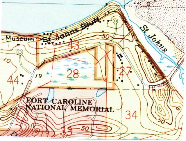
Below, a topographical map titled Mayport, 1:24,000 scale, 1994, showing private dwellings on the slope north of and below the Ribault Pillar Monument, the road ending in a cul-de-sac, at an elevation of 70 feet. Marsh exists on the banks of the St. Johns Creek, east of the Bluff's east face or escarpment. I understand the steep east bluff-face or escarpment facing St. Johns Creek is the "brow of the mountain" the French refugees descended at the peril of their lives after the Spanish had captured Fort Caroline (cf. the Fort's French Carpenter Le Challeux's account for the details). Fort Caroline is probably above the number 43 on the map, near the shore. This scenario would have the French survivors fleeing east from the Fort to the "brow of the mountain," the steep face (east of number 27 ) of St. Johns Bluff facing St. Johns Creek on the below map. Perhaps the cluster of private homes east of the Museum is where Fort Caroline is, just nearer the river's shores. They lie closest to the freshwater ponds (Fort Caroline's water source?)
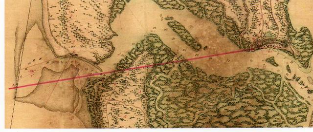
Below, I have drawn a red line atop a modern (2013) map of the St. Johns River showing the view from St. Johns Bluff (the Ribault Pillar Monument at an elevation of 70 feet) to the mouth of the river. French accounts state that from this "small hill" they could see sails in the harbor or anchorage at the mouth of the river. When a tree was climbed at this point, ships' sails could be seen beyond the bar (sandbars) outside the river's mouth. As telescopes were not invented until the 1600s the sighting of ships and their sails at the mouth of St. Johns River from St. Johns Bluff (the modern Ribault Monument) was by naked eye. The river's mouth is about 5 miles east of the Bluff, Laudonniere's 2 leagues (one league is about 2.6 miles). Today, 2013, one cannot see the mouth of the St. Johns River nor its Bar from this elevation, the Ribault Pillar Monument parking lot and viewing platform. Why? It seems that bulldozers in creating a road and parking lot there have reduced the elevation from 86 feet (1917/1950 maps) to 70 feet.
James Craig Morris, a Park Ranger at the Fort Caroline Memorial Reserve (He died, aged 58 years shortly after retirement, in September of 2020) had proposed that Fort Caroline is near Fulton Point, a location west of St. Johns Bluff. The problem? The nearest elevation is only 40 feet high according to modern topographical maps (1950) and its view of the river's mouth is blocked by the 80-90 feet high St. Johns Bluff. Only if the French hiked from Fulton Point to St. Johns Bluff would they be able to see the mouth of the river and ships' sails.
Modern topographical maps (1950) reveal that no elevation east of St. Johns Bluff is higher than 20 feet and most are no higher than 10 feet, so the mouth of the river should be viewable from the Ribault Pillar Monument, especially if one climbed a 20 ft. high tree on this spot to see the bar at the river's mouth and ships' sails as is stated in the French account. I understand the "small hill very near the fort" where French sentries looked for ships' sails is the small hill or knoll that the Ribault Pillar Monument sits atop. Another "hill" mentioned is between Spanish Pond and the Fort and is the western hill ridge from the Monument to Calypso Island.
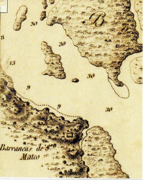
Below, a map of the St. Johns River made in Madrid, Spain in 1809. It shows St. Johns Bluff as Barrancas de San Mateo "Bluffs of San Mateo," and a rectangular building atop the bluff which might be Fort San Mateo in 1809? The map's importance is that in 1565 the Spanish conqueror of Fort Caroline renamed the French fort San Mateo and the river May, Rio de San Mateo and in 1565 the Spanish said Fort Caroline was near a barranca alta, "high bluff." Evidently as late as 1809 the name San Matheo and its Barranca still lingered at today's St. Johns Bluff, which is but an American rendering of England's St. John's River (leaving out the apostrophe) a translation of Spanish Rio de San Juan. Some English and French maps of the 1764 label the river as San Matheo or San Juan/St. Jean. The dotted line is shallow water, could this be a former shoreline on which the fort was built? If so, then the fort may be under the river today (2020)? On this map the river is called Rio de San Juan and it is available on the internet Title: Boca y Barra Del Rio San Juan.
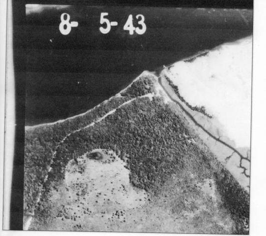
Below, an aerial photograph of Aug. 5, 1943 of St. Johns Bluff showing forest up to the banks of the St. Johns River. Spanish Pond appears as a dark spot near the top edge of a somewhat treeless depression south of the road ascending the bluff. I understand the 1565 accounts speak of a spring and marsh south of the fort. The below photo shows the spring (?) or pond as a dark spot, the marsh as the lighter treeless area about the spring. Available on the internet as "Aerial photographs of Duval County, Flight 6 C (1943)." St. Johns Creek is east of the bluff, east of it is Buck island shown to be mostly sand.
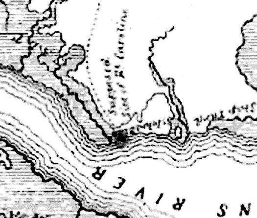
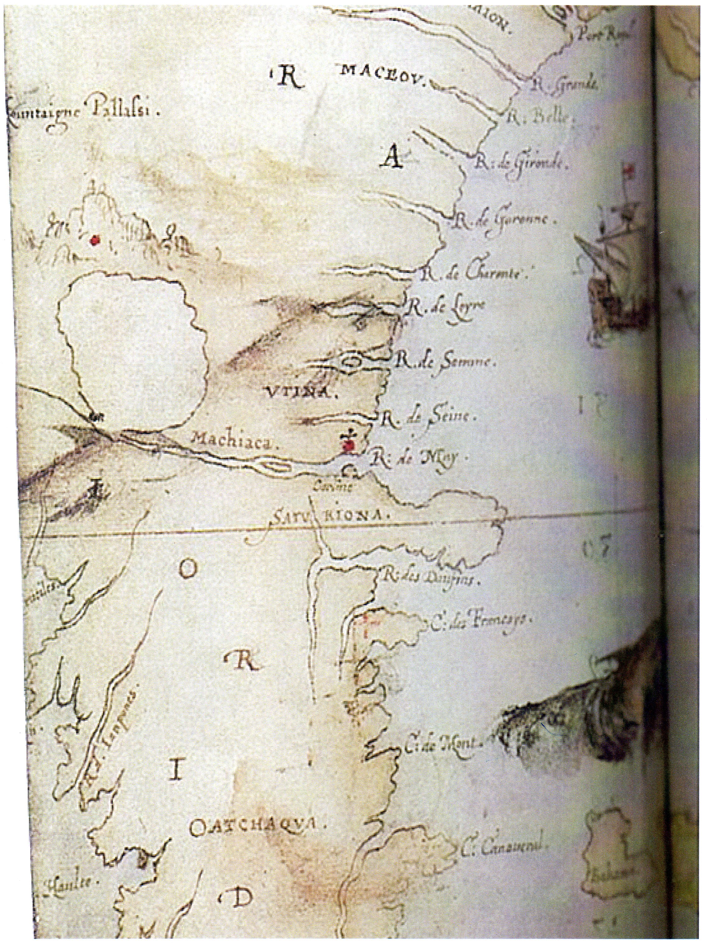
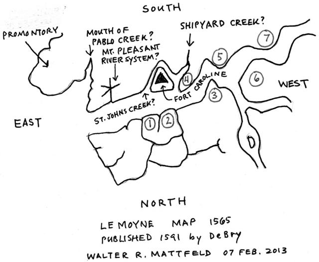
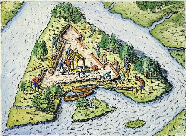
Below, Fort Caroline (Carolina) appears on the southside of the May River (Latin: Fluvius Maii) in
the 1565 Map attributed to Le Moyne (published 1591 by DeBry). Strangely the fort is shown as surrounded on all three sides by a stream or moat. Laudonniere said the west side of the fort faced land, the other faced the river and the map shows the May river as "east of the fort," or perpendicular to the fort's east wall, descending from WNW to ESE. Laudonniere described Fort Caroline as being a triangle and the map shows it thusly. Could the streams on the map east and west of the fort be St. Johns Creek and Shipyard Creek? Or is the fort on Calypso Island, which is surrounded on three sides by rivlets draining into Shipyard Creek (see Google Earth satellite photo of 2013)? Strangely missing on this map is the island that divides the May River into two arms in the DeBry engraving of men in ships at the mouth of the river (which I have proposed might be Great Marsh Island).
Below, John White's Map (1585) showing Carline (Fort Caroline) to be associated with a promontory on the south side of the May River (R. de May) jutting out into the river. North of the promontory is a red dot surmounted by a cross which may refer to Fort Caroline? Why locate the fort on the north shore? A map allegedly from a Frenchman at Fort Caroline, accompanying his letter to France, shows the fort on the north bank of the May River. It is further stated the fort is 6 leagues upstream from the river's mouth (cf. pp. 68-69. Charles E. Bennett. Laudonniere and Fort Caroline, History and Documents. University of Alabama Press. 2001, reprint of 1964). Other accounts say the fort is on the south bank and 2 leagues from the river's mouth. Why the confusion? it might be deliberate? Maps were guarded as secret knowledge to be denied others. By giving false degree readings, false locations and false distances your enemies could become confused in attempting to find your settlement and destroy it? In other words the maps (depositions and accounts) may have been falsified as a means of self-preservation? Maybe this accounts for the greatly exaggerated promontory (shown split in half by the 30 degreees north latitude line) between the May River to its north and the River of the Dolphins to its south? For the map see p. 96. "La Virgenia Pars in Kim Sloan. A New World, England's view of America. London.. Trustees of the British Museum. 2007)
The map does not show an island east of Fort Caroline (Great Marsh Island?) dividing the river into two arms. The island is west of the fort (Carline on the map), and may be the 1856 map's "Long Island"? The map is inaccurate by showing the River May flowing from a lake near the Apalatchy Mountains to the north. The French Parreus Map of 1562 and the Lemoyne Map of 1565 correctly show this lake to be southwest of the river's mouth. Obviously White had no knowledge of the 1562 and 1565 French Maps, for he would have located the lake (today's Lake George) southwest of the river's mouth.
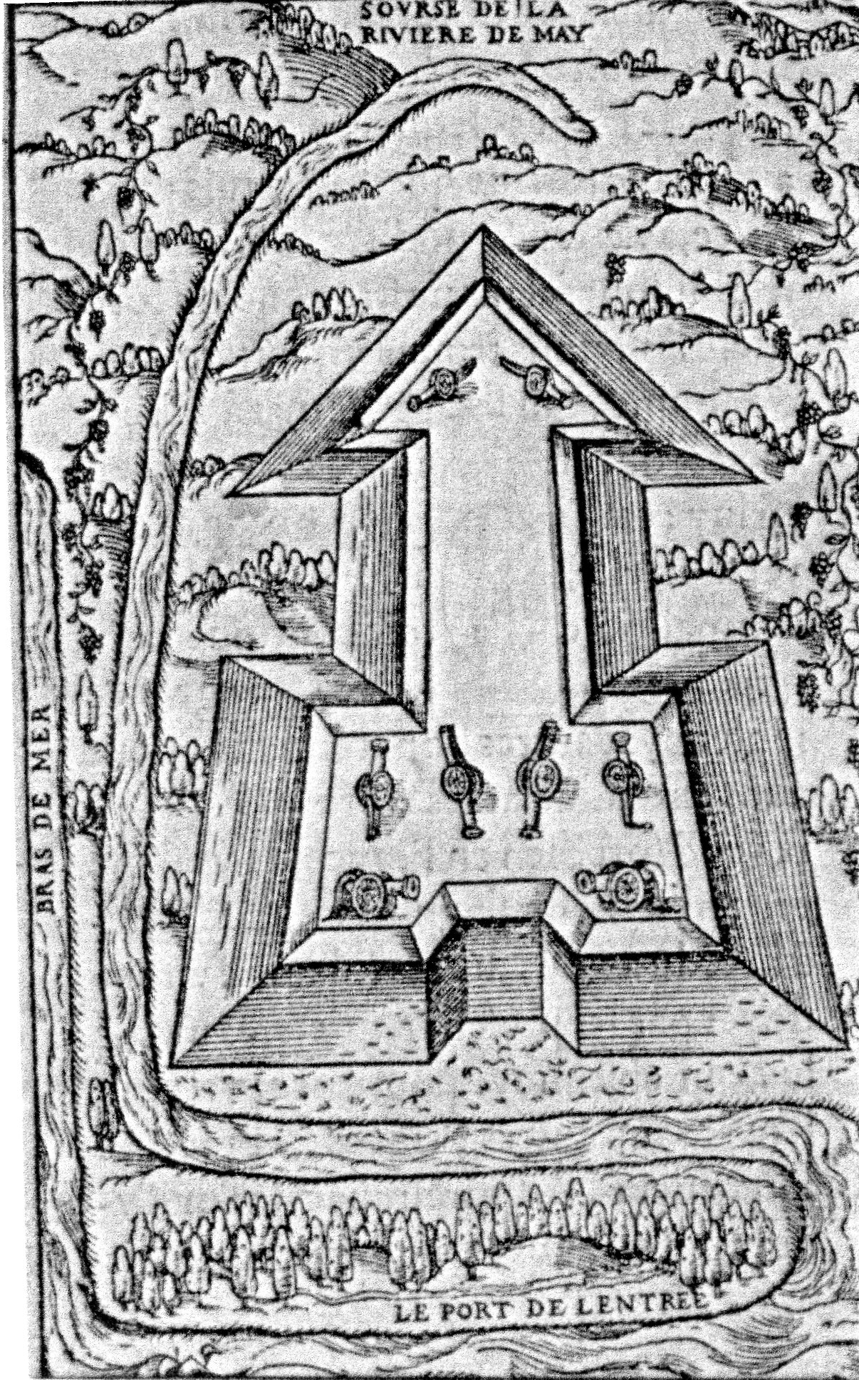
Below, a copy of a map supposedly accompanying a letter from Fort Caroline (1564), showing the fort to be on the north side of the May River. To the viewer's left, a portion of the Atlantic Ocean is shown and labeled Bras de Mer, "arm of the sea." At the river's mouth the May Port peninsula is labeled as Le Port de L'Entree, "The Port of Entry,"revealing that entry from the Sea, The Bra de Mer, is at this point is fiction, modern maps reveal the Bra de Mer is the Atlantic Ocean (early maps of the 16th century show incorrectly today's May Port Peninsula to a promontory jutting out into the sea. I have doubts about the accuracy of this map. Other maps show the fort to be on the south bank of the river. The letter accompanying the map says the fort is 6 leagues from the river's mouth but other accounts state it is no more than 2 leagues from the river's mouth. Perhaps this information was deliberately falsified by the French letter writer to protect the fort from being found and destroyed by enemies? The fort is not a Triangle but rather like an arrow with feathers at its tip (cf. De Bry's Le Moyne Triangle fort). The fort's east and west sides in other accounts face the river. This map shows the fort bounded by the May River on three sides, east, south, and west, suggesting to me a promontory on the north side of the river. The letter claims a moat is being built to be filled with water from the river upon its completion, yet the drawing does not show such a moat (cf. pp. 68-69. Charles E. Bennett. Laudonniere and Fort Caroline, History and Documents. University of Alabama Press. Tuscaloosa and London. 2001. Reprint of University of Florida Press, 1964). If a moat was indeed built later, and filled by river water, then the fort was near the shore of the river and not atop the Bluff. The problem? Other accounts suggest the moat was only an open dry defensive ditch, not filled with water.
"The fort is in the said River May, about six leagues up the river from the sea, which we will shortly have so well fortified as to have it defense-worthy, with good conveniences and the water coming into the moat of the fort." (p. 68. Charles E. Bennett. Laudonniere and Fort Caroline, History and Documents)
Could the below map be showing May Island (Parreus 1562 map), later called Isla de San Juan (1702 Colonel Moore map), Baffin Island (1856 U.S. Coastal Survey map), today's Fort George Island (DeLorme Atlas)? If so, then the "Source of the May River" being shown is today's Sister's Creek, known to the Spanish as one of the Bocas de Santa Cruz, "mouths of Santa Cruz" (Sister's Creek being one of the mouths or bocas, see the 1702 Colonel Moore map and the Boca del Rio de San Juan 1809 map). Some Frenchmen might have considered Fort George Island to be an ideal location to deny enemy entry into the May River (today's St. Johns River)? Pedro Menendez de Aviles was told by French Mutineers from Fort Caroline who were captured and sent to him (while he was still in Spain) from Havana, Cuba, that he could control entry into the May River by fortifying an island that was near the river's mouth. When he got to the May he related that the French had already fortified this island so he abandoned the enterprise and returned to St. Augustine. Is the below map of a proposed French fort on Fort George Island? Were there two French Forts? Fort Caroline at St. Johns Bluff and a smaller fortification at the river's mouth, perhaps in the vicinity of Pilots' Town? Between 1565 and 1568, after the fall of Fort Caroline, the Spanish did follow-up on the French mutineer's suggestion and a blockhouse fort was constructed on both sides of the mouth of the river to deny entry by enemy ships. These two forts were one league downstream from Fort Caroline. They were destroyed by the French in 1568 along with Fuerte de San Matheo, the former Fort Caroline.
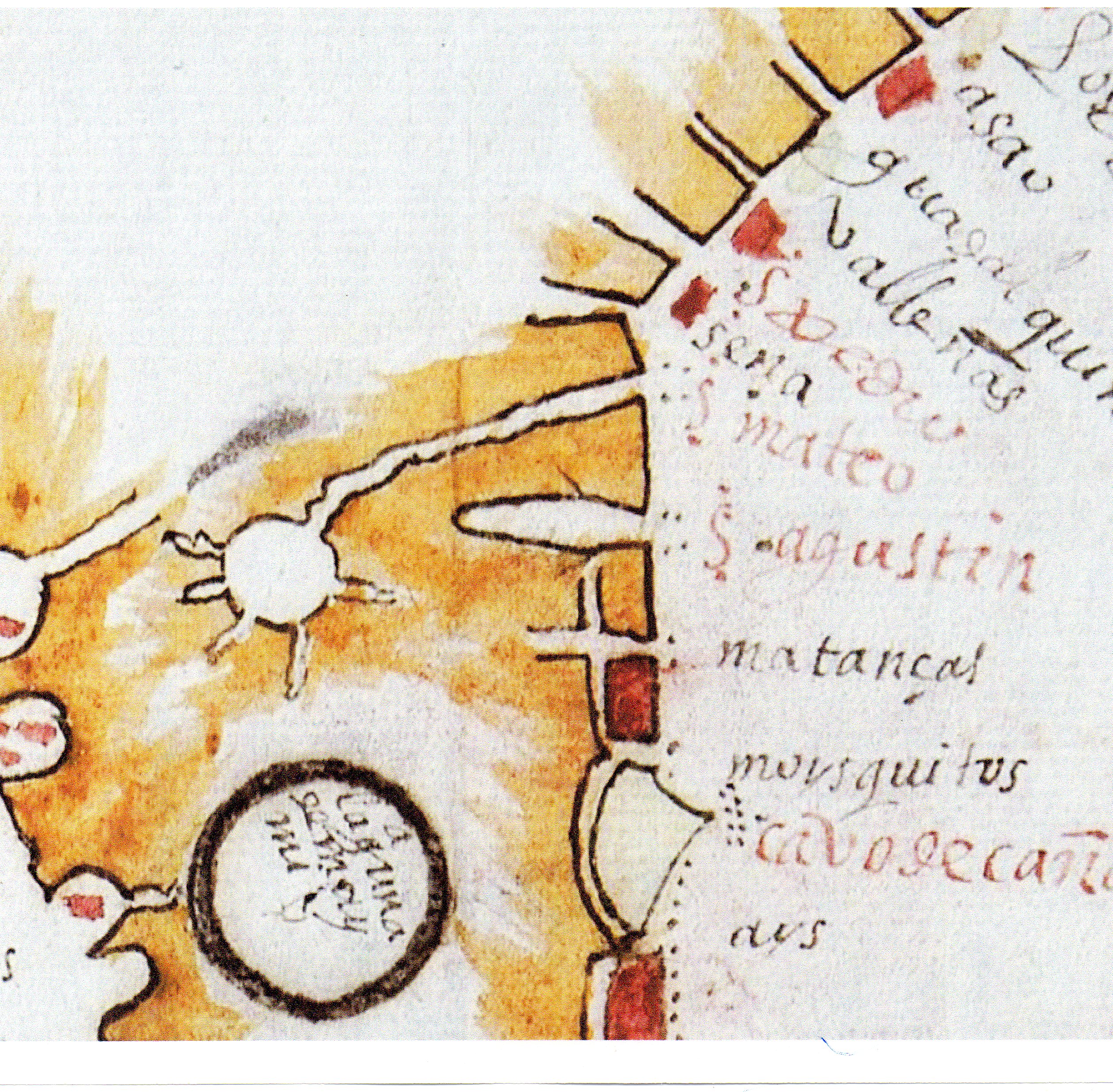
Below, a Spanish map, circa 1601, showing the San Mateo River (S. mateo in red ink) to be north of San Augustine (S. agustin in red ink) and its source a large lake to its southwest. The source of the St. Johns River are lakes (today's Lake George) to its southwest. The black ring circle says Laguna de Miami. Below S. agustine is matancas (Matanzas River's south inlet), mousquitos (Mosquito Bay) and Cape of Canaveral (cavo de canaveral in red ink). Available on the internet at the Spanish Archivo General de Indias, Mapa de la Florida y laguna de Miami, mp_Florida_Luisiana, 7.This map supports Pedro Menendez de Aviles' statement that the Rio de San Mateo (French May River) running past Fort San Mateo (French Fort Carolina) connects with the Bay of Juan Ponce (which lies on the southwest shore of Florida near Port Charlotte). He was wrong, it doesn't connect with the bay. Richard Thornton's notion, based on some maps of circa 1590-1790, showing that the May River is Georgia's Altahamah River and Fort Caroline is near Darien, Georgia, doesn't align with de Aviles' statement (1565) that the San Mateo river goes south to the Bay of Juan Ponce, as the Altahamha flows to the ESE from the Applachian Mountains. This map correctly shows the source of the San Mateo river to be a lake to the southwest of its ' mouth in that its mouth is like the Le Moynes' map of 1564 published in 1591 by DeBry. It is even superior to DeBry's (Le Moynes) map in that it shows no river descending from the northwestern Appalchian mountains in Georgia like so many other, later, maps.
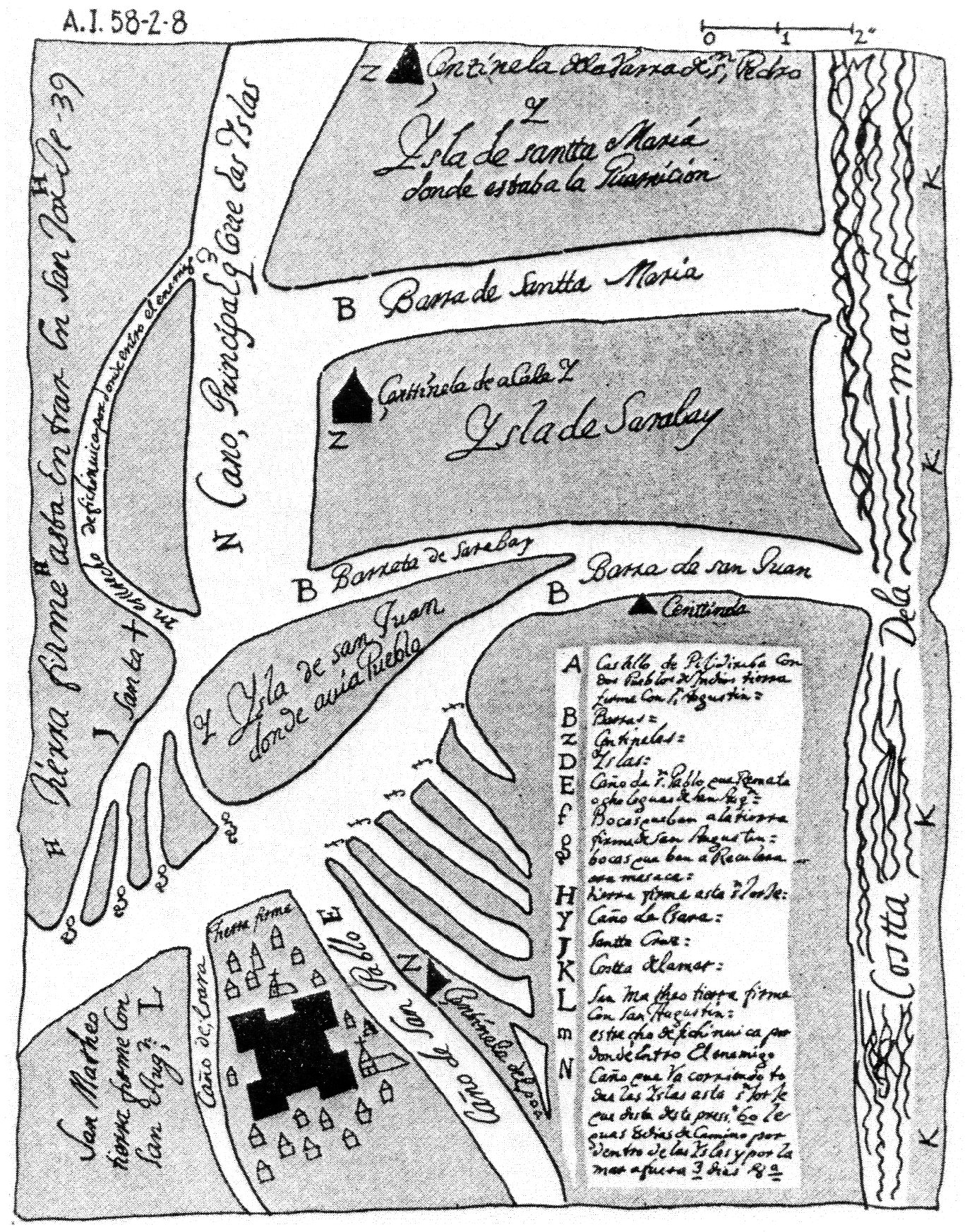
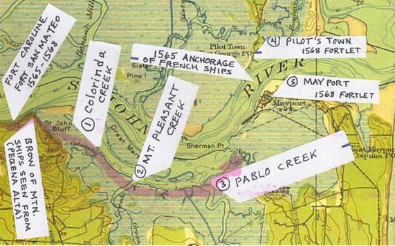
Below, a map circa 1702, in Spanish, showing sites near today's St. Johns River, attacked by Colonel James Moore's army in its advance on St. Augustine. San Mateo appears at the promontory on the southside of the Rio de San Juan who's mouth is given as Barra de San Juan. The inscription reads: San Matheo tierra firme con San Augs[tine], "San Mateo, firm land with San Augustine." Today's St. Johns Creek at the east of St. Johns Bluff is labeled Cano de Crara, its lower reaches are Pleasant Creek. East of San Mateo is San Pablo Creek and a Spanish fort, Castillo Piribiriba, with 2 Indian villages with two mission churches. The text says it is 8 leagues from San Pablo to St. Augustine (cf. p.179. Jerald T. Milanich. Laboring in the Fields of the Lord, Spanish Missions and Southeastern Indians. University Press of Florida. Gainesville. 2006). I note that Pedro Menendez said it was 8, 10, or 15 leagues between St. Augustine and Fort Caroline which he renamed San Mateo in 1565.
The black triangles are labeled Centinela, meaning "Sentinal outposts." This map is also available on the internet in color. Three islands (Spanish Isla) north of the Rio de San Juan (St. Johns River) are Isla de Santa Maria, Isla de Sarabay, and Isla de San Juan "where existed a Pueblo" (village). The Mateo River's name changed to San Juan, after the Spanish Mission on San Juan Isla, called San Juan de la Puerta, (puerta meaning portal or gateway). Opposite San Matheo (to the north) is Santa +, or Santa Cruz River and its bocas or mouths that creates a swamp or marsh extending east to Isla de San Juan or today's Fort George Island.
Below, a Spanish map made in 1737 showing San Mateo as a fortress on the St. Johns River, Spanish: Barra de San Juan. To its south is the fortress at San Augustine on the Matanzas River, Spanish Barra de Matansas, further south is another fortress at the southern inlet of the Matanzas River at the south end of Anastasia Island. So 3 Spanish forts appear on this map. The importance of this map is that as late as 1737 San Mateo existed as a fortified site despite some scholars' claims that fort San Mateo had been abandoned by the Spanish by 1570. Map titled Descriptio Geographica, de la part que los Espanoles poseen Actualmente en el Continente de la Florida. Cartographer: Antonio de Arredondo. Available on the internet. The problem? Another more highly detailed Spanish map by Antonio de Arredondo of 1737 shows a road from St. Augustine to the site named Barrancas de San Matheo and states it _had been_ a populated site. No buildings or fort are shown. But Fort George is shown on Isla de San Juan (today's Fort George Island) and Fort San Marcos is shown at St. Augustine. This aligns with the 1702 Colonel Moore map showing no buildings at San Matheo.
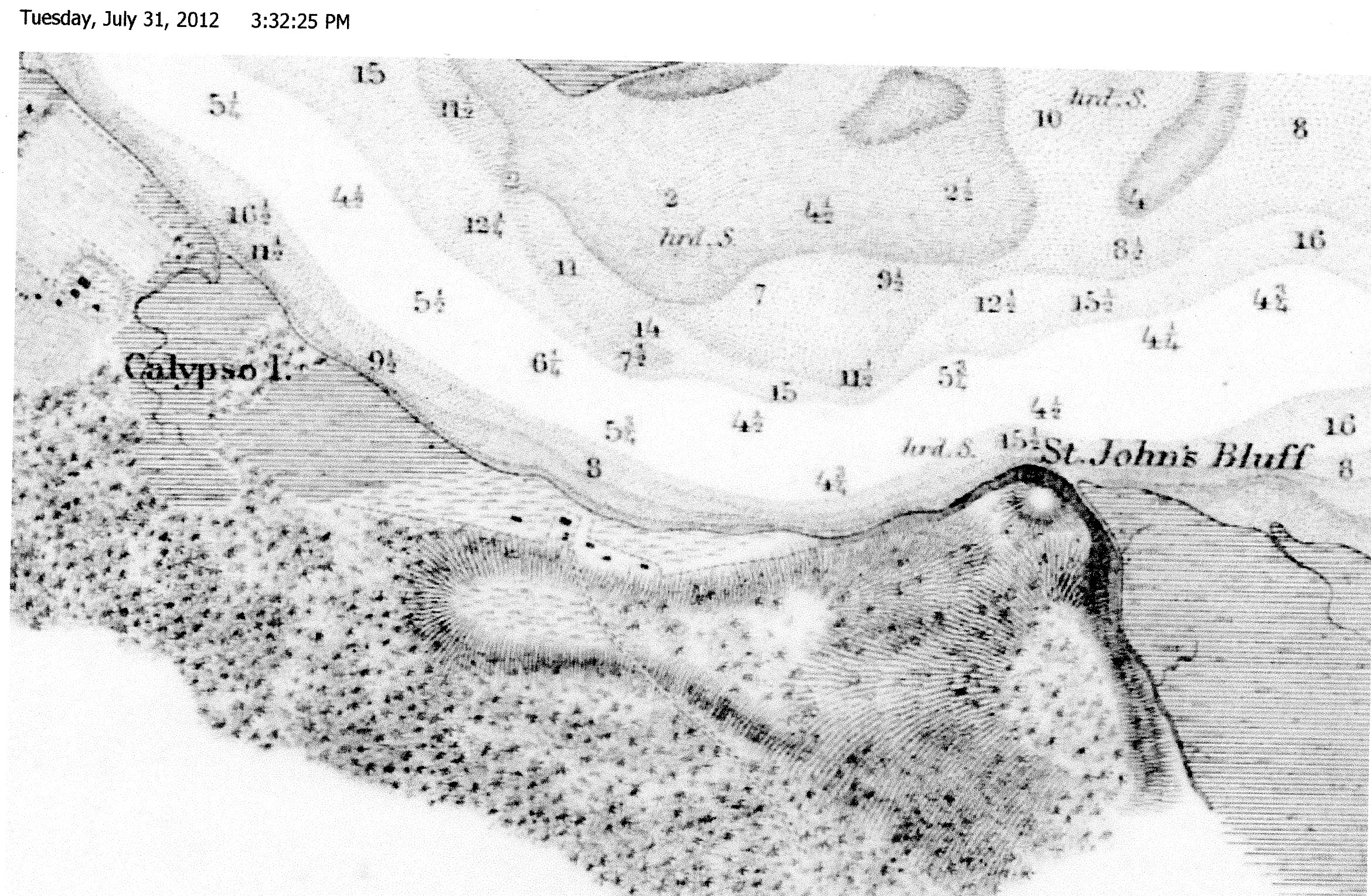
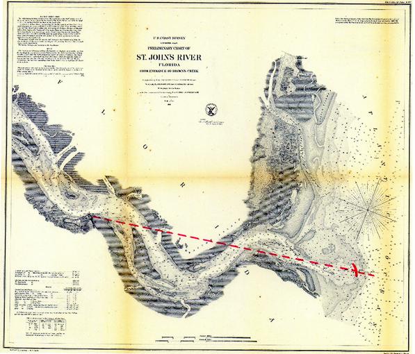
Below, 1856 Survey Map of depths of the St. Johns River from Brown's Creek to the river's mouth. Fort Caroline was "below a small hill, on the bank of the river, with an open plain one bowshot in length from the fort to the woods at the hill's top, there was a path from the fort ascending the hill to a spring in the woods." This map reveals that an open plain exists west of St. Johns Bluff promontory and shows a path or road ascending from the open plain to the woods where today exists Spanish Pond. Is the pond "the spring" mentioned by Laudonniere? All this suggests the fort is west of the promontory and bordered on its south side by an open plain terminating in wooded hill slope. Perhaps the houses on this map overlie, in part, the remains of Fort Caroline (Fort San Mateo)?
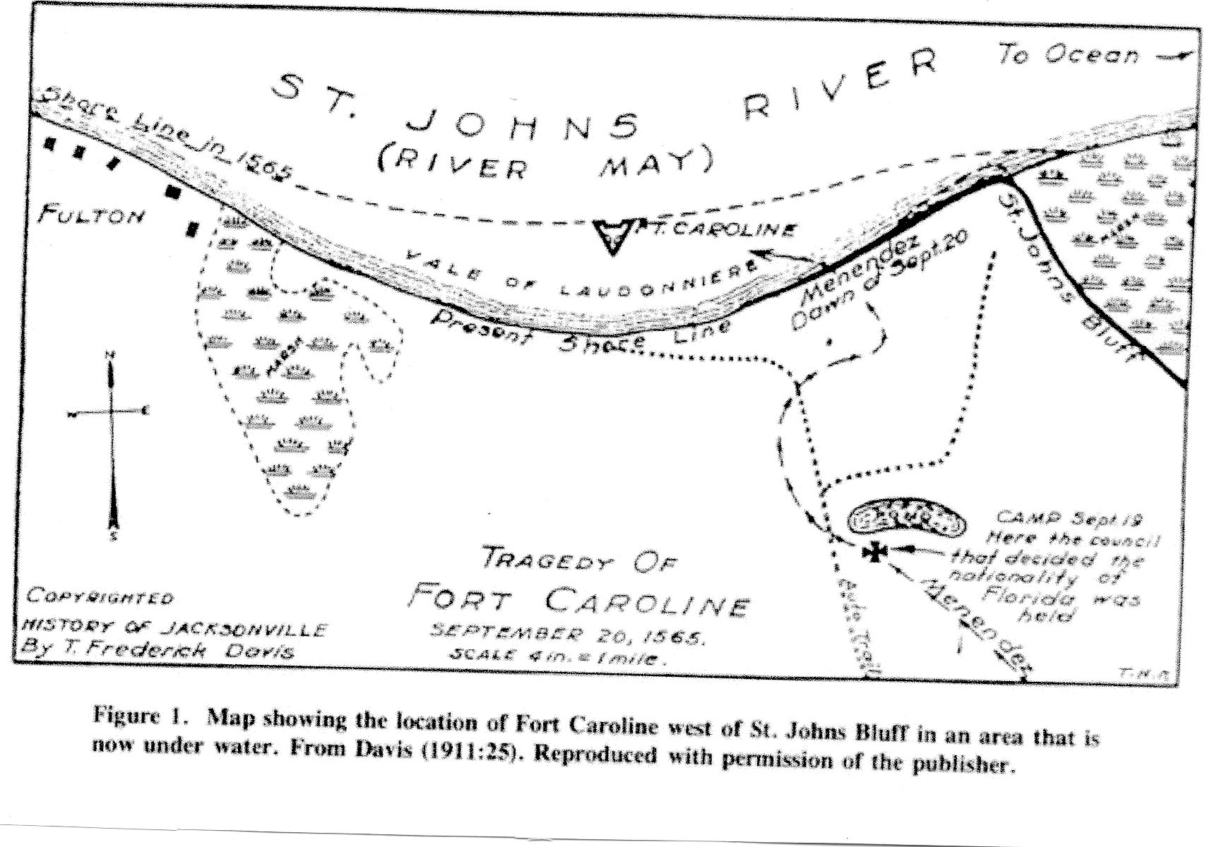
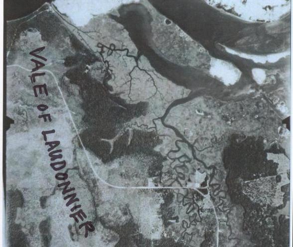
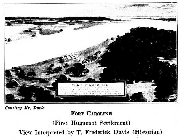
Below, map after Davis (p. 12 figure b. T. Frederick Davis. History of Jacksonville, Florida and Vicinity, 1513-1924. Press of the Record Company. St. Augustine, Florida. 1925), showing Fort Caroline on an (imagined) washed away shoreline. In 1858 Fairbanks opined that the fort was on a washed away shorleine and located the fort west of the St.Johns Bluff promontory. Apparently Davis accepted Fairbanks' proposal. Spanish Pond is probably the marsh that the Spanish spent the night in before attacking Fort Caroline. Davis has the "Vale of Laudonniere" being the north shore of St. Johns Bluff. Apparently Bennett (1975) agreed with Davis (1925) as he says the reconstructed fort (1964) is in the Vale of Laudonniere:
"62. A portion of the Vale of Laudonniere has not been eroded by the St. Johns River, and in it Fort Caroline has been reconstructed." (p. 221. Charles E. Bennet. Three Voyages, Rene Laudonniere. University of Alabama Press. Tuscaloosa and London. 2001. 1975, University Presses of Florida)
I disagree about their proposal for the location of the Vale of Laudonniere being the shoreline of St. Johns Bluff. Why? The account portrays his party of men as having left the shore of the river and they are exploring the woods or forests to the south of the hill-ridge. They come to a small hill and from its height they see a broad vale, described as flat, with green grass fit for cattle and interlaced by numerous brooks of fresh water They call it the Vale of Laudonniere. The problem? Fort Caroline lies at the end of a slope (slopes aren't flat) at a river's edge. There are _no_ "numerous brooks of fresh water "crisscrossing the north slope and shore of St. Johns Bluff. Enroute back to their camp at St. Johns Bluff they meet an Indian woman who provides them with water. Laudonniere said that refreshment gave them the strength to carry on in their march back to the banks of the May River and camp on its shore that night (cf. pp. 69-70. Bennett. Three Voyages. 2001). The Vale of Laudonniere thus cannot be the bank of the St. Johns River. For me, it could be one of two sites: (1) If the vale is south of St. Johns Bluff, perhaps it is the area shown with marsh-laced freshwater streams on the 1917 topographical map (scroll down for the map) or (2) The marshes of Chicopet Bay to the east of St. Johns Bluff are "flat," "green," and interlaced by numerous creeks and "brooks" of fresh water. Buckingham Smith (1868) speaks of Mayport Mills being in the Vale Of Laudonniere, so evidently the marshes east of St. Johns Bluff were for him the Vale's location. He was a U.S. Consul to Spain and did research on Fort Caroline and Fort San Mateo in the Spanish Archives which he shared with George R. Fairbanks of St. Augustine, Florida.
Laudonniere suggests the fort's river-facing wall is on the bank of the St. Johns River, not atop the Bluff's promontory where Confederate cannon were positioned in 1862:
"We began to repair and refortify what had been demolished, principally on the river bank where I ordered sixty feet of timber to be replaced in order to re-establish the palisades. The planks for this came from the ship which I had built. Notwithstanding all our diligence and work, it was not possible to rebuild the fort completely because of the bad weather and the winds." (p. 162. Charles E. Bennett. Three Voyages, Rene Laudonniere. Tuscaloosa and London. University of Alabama Press. 2001. Reprint of 1975, University Presses of Florida)
If an open plain exists between the fort and the wooded hill top behind it, the 1791 and 1856 maps suggest the open plain is west of the Bluff promontory, not the promontory itself (especially the 1856 map which shows no open plain atop the promontory).
"Against" Fort Caroline being underneath the 1791 fortress is that the eyewitness account says that the Spanish spies when they got to the top of the hill ridge all they saw was the river and a house, not the fort. The 1791 fort is at the top of the hill ridge, if Fort Caroline was atop this hill ridge they should have seen it! The spies continued further down the path and then saw the fort. The Frenchman who brought them to the area as a prisoner said the fort was beyond the hill (by 3 bowshots) and near the river. A fort atop the hill ridge (the 1791 Fort) doesn't match the eyewitness statements!
The map key written in Spanish, accompanying the 1791 map under the heading of the alphabetcal letter V, which is east of and adjacent to a small mound or hill, says: Pequena altura que descubre hasta la Barra, roughly translated as "A small height, [from] it you can discover [view or discern the area?] up to the Barra." Barra in Spanish is English Bar and it usually refers in both Spanish and English of the 1500s to sandbars at the mouths of rivers that ships must navigate past to enter the river's mouth for an anchorage or harbor. I note that Laudonniere said that from a small hill he could see ships' sails at the river's mouth and sent a man up a tree atop the small hill who said he could see ships at anchor outside "the Bar" and seven row boats crossing the Bar! I am proposing that Laudoniere's "small hill" is the Spanish 1791 map's Pequena Altura ("small height") from which he could not only see as far as the Bar, but also look down and see his men in Fort Caroline leaping for joy and dancing about when his messenger told them the news that ships had been sighted. Fort Caroline has to be very near this small hill, which I understand today's Ribault Pillar Monument sits atop. Laudonniere said the Fort was _"very near_this small hill."
The below 1791 map shows the Pequena Altura (Capital Letter V to the hill's east) by todays' St. Johns Creek and Buck Island. Note, a plain appears to be in existence north of and below the small hill and a house (Captial Letter R "casa") is just west of the hill on the promontory plain. Z is the road to Fort San Diego, U the Pueblo or village S the Hill ridge is called Monte or "Mountain." The Hill ridge on its east side is 80 feet high and at it western end 40-30 feet high on modern topographical maps (1950). Red lines from the fort are of 8 cannon trajectories The plain is shown devoid of trees except the slopes of the hill ridge where lies the fortress. Fort Caroline had an open treeless plain about "one bow shot in length," terminating in forest "above the fort." When le Challeux reached this elevation he looked back and saw the interior of the fort, its three walls bearing Spanish military standards or flags showing the fort was now in Spanish hands and the corpses of Frenchmen piled up near the river by De Aviles' men. If under water, could Fort Caroline be on the submerged promontory at the mouth of Shipyard Creek?
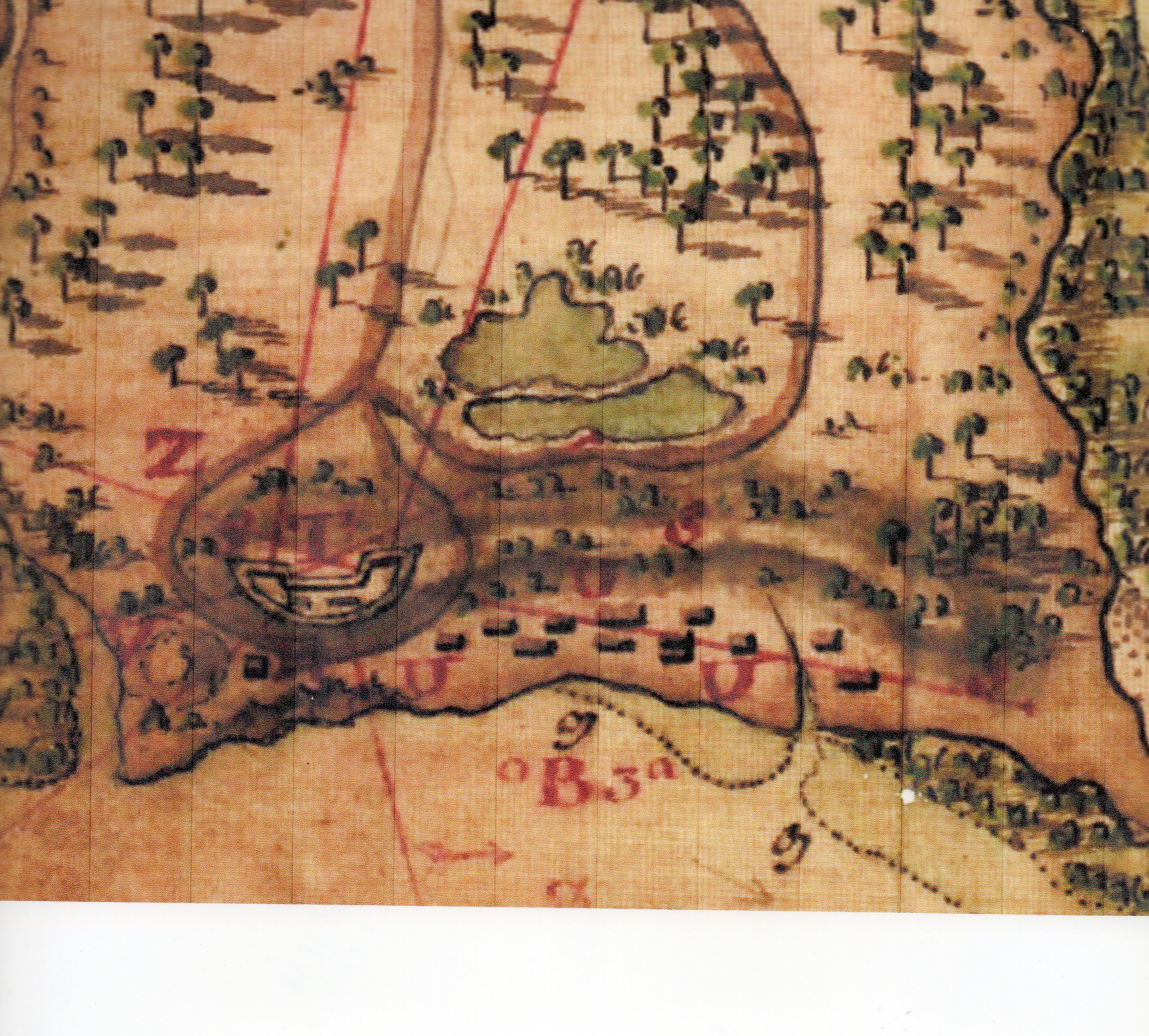
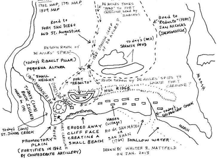
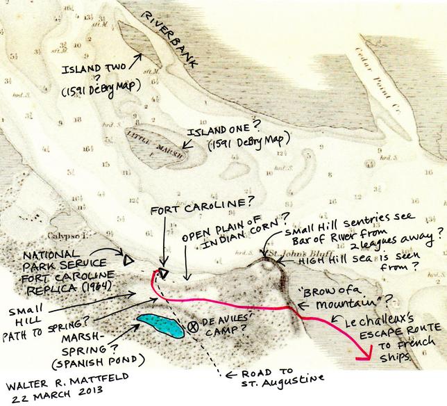
Below, "my redrawing" (04 January 2013) of the above 1791 map showing my proposal for Pedro Menendez de Aviles' march from St. Augustine to Fort Caroline in 1565 via a road, used by Indian guides, who brought him to a marsh at night to attack the Fort on 20 September 1565 at dawn. He sent two men from this marsh "up a hill" to locate the fort. They saw the river and a house only. Descending on the hill-path, they then saw the fort. They came back to camp via another path. Laudonniere said the fort was "very near" a small hill from which ships' sails at the Bar (the sandbars at the river's mouth) could be seen if one climbed a tree. The 1791 map says the Pequena Atura "small height" provides a view all the way to the Barra, (the sand bars at the mouth of the St. Johns River). Three maps were consulted (1) 1702 showing San Mateo as a promontory west of San Pablo Creek, (2) 1791 Map (above), and (3) 1809 map showing St. Johns Bluff by today's St. Johns Creek to be labeled as Barrancas de San Mateo with a building atop it (a fort?). Shipbuilder's Creek on the below map should read Shipyard Creek. Update of 06 March 2013: The 1791 map suggests a plain exists adjacent to the pequena altura, but the 1856 map disagrees, the open plain is further west. The 1856 map appears to be more accurate when compared with modern topographical maps (1950 scale: 1:24,000), so I will have to give up my earlier notion that Fort Caroline is below the St. Johns Bluff promontory, its more probably west of the promontory, near the river bank, and perhaps , in part, under the houses on the 1856 map?
Below, a Google Earth sattelite image of St. Johns Bluff . I have with a razor blade cut out the image of today's scaled down model of Fort Caroline erected by the National Park Service and glued it over the Promontory of St. Johns Bluff, north of, and below, today's Ribault Pillar Monument to show how large an outline the fort would leave in the earth of its triangular dimensions. The small gray opening below the fort is the parking lot for the Ribault Pillar Monument, which I have argued, is the 1791 map's Pequena Altura "small height" from which the Bar at the mouth of the St. Johns could be seen. Laudonniere (1565) said the fort was very near a small hill from which if a tree was climbed, the Bar at the mouth of the May river could be seen and ships sails at anchor beyond the Bar. He also could look down from this small hill and see his men inside the fort, leaping about and their cries of joy that the ships had been sighted from the small hill. The spring which provided frersh water to the French is shown as a dark spot in a clearing which becomes a marsh at times of high water from rains. A spring and marsh appear in the 1565 accounts south of the fort.
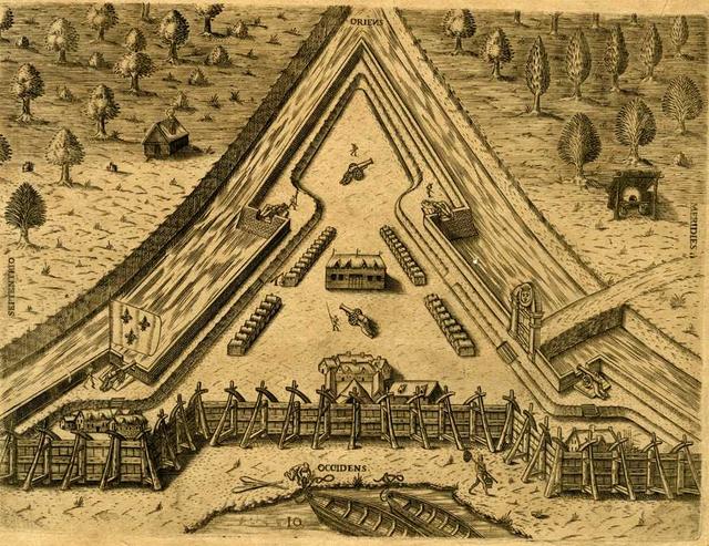
Below, the 1591 DeBry's engraving has Fort Caroline's gate face the south (Latin: Meridies) the viewer's right. Small row boats are beached near the west (Latin: Occidens) side of the fort, viewer's bottom. North (Latin: Septentrio) is to the viewer's left. The problems? Another engraving by DeBry (1591) shows the fort being erected on an island surrounded by a stream on all three of its sides and the arcing-shoreline with two small beached boats is labeled F. Maii in small print. The below map shows the fort's arcing-shoreline to be west of the fort, not north of the fort, where today (2013) one finds the arcing-shoreline of the St. Johns River from St. Johns Bluff to Fulton. Ergo, I understand that DeBry is in error in labling the arcing-shoreline as west of the fort, it is north of the fort. This means the fort's gate and defensive ditch or moat should be on the westside.
My scenario has the Spaniards attacking from the south, from Spanish Pond, crossing the St. Johns Bluff western hillridge (which is 40-50 feet high) and engaging the French first at the fort's southwestern wall, then its western gate. The fort's western wall and its moat was only a defensive dry ditch about 9 feet deep according to Laudonniere. Perhaps rainwater filled this dry moat at times when hurricanes struck?
The notion that the fort had a water-filled moat is from what I regard as a "spurious letter" saying a soon to be made moat is to be filled with river water, and that the fort is 6 leagues from the river's mouth, and it is shown on the north side of the May River. I suspect the French letter writer was providing false information to protect the fort's whereabouts. It lies on the south side of the May River and it is said by Laudonniere and Hawkins to lie "not more than 2 leagues from the river's mouth."
Some scholars are of the opinion that Fort Caroline was built on the bank of the May River which has since been washed away. What are the clues for this understanding?
Pedro Menendez de Aviles in a letter (1565) to the King of Spain, mentioned finding 3 boats _in_ the fort which the French were in the act of repairing apparently. This would suggest the fort is on the shore and not on the Bluff as it is unlikely boats would be placed atop a 70 foot high bluff for repairs:
"...the others escaped by swimming out to the two boats of the three vessels that were opposite the Fort...I sent them a cannonade and call of the trumpet to surrender themselves, vessels and arms. They refused, so with artillery found in the Fort we sank one vessel; the others taking up the men went down the river where they had two other vessels anchored laden with provisions, being of the seven sent from France, and which had not yet been unloaded. It did not seem to me right to leave the Fort and pursue them until I had repaired three boats we found in the Fort." (p. 132. Bennett. Laudonniere and Fort Caroline, History and Documents.)
French accounts state that experienced ships' carpenters did create small craft to explore the May River with.
A Frenchman's deposition on the location of Fort Caroline apparently _in_ a marsh rather than atop a bluff:
"..the entrance to the port where they were located was through a river...in the said river there was a marsh on which they had built a tower of stone and wood which was very strong and on which they had mounted twenty pieces of artillery..." (p. 104. Bennett. Laudonniere and Fort Caroline, History and Documents)
How are we to understand this fort in a marsh? One possibility is that St. Johns Bluff is bordered by marsh on its west and east sides. West is the marshes of Mill Cove Bay, east is the marshes of Chicopet Bay. Alternately, west of the St. Johns Bluff is the marsh of Shipyard Creek and east is the marsh of St. Johns Creek.
A Frenchman has the fort 2 leagues from the river's mouth at a high hill above the arm of the river on the southwest bank. Possibly suggesting the fort is on a rover bank, near a high hill:
"Questioned as to in what parts of the said port the site and fort are established, he said that it may be two leagues from the mouth of the river, at a high hill, which is above one arm of the said river on the southwest bank." (p. 97. Bennett. Laudonniere and Fort Caroline, History and Documents)
How to understand one arm of the river at a southwest bank? Is this the St. Johns as it turns ESE at the Blluff headed for Chicopet Bay and Pablo Creek? Or is today's St. Johns Creek that is being alluded to east of the Bluff?
The fort is 4 or 5 leagues up river past sand bars and at 29 l/2 degrees, which, surprisingly, is the reading de Aviles gave for St. Augustine!
"...they came to Florida. The first land they came to was at 30 degrees, and then they went down to 29 1/2 degrees where they found a river...four or five leagues up the river, at which point the people of this armada established a village. From here on up, the river is more soundable and all fresh water, and so wide in some places that one cannot see across from one shore to another...They built a fort of timber and faggots, four or five leagues in the mouth of the river past the banks above mentioned before...fifty Africans...four French housewives. Into the fort they put four medium-sized cannon, and eighteen culverins, and great quantities of all kinds of ammunition...Where they built this fort the river is narrow, and they settled there in order to defend the passage with artillery against those who might want to pass ahead; because of this the fort is on the river bank and the range of the artillery easily covers from one bank to the other." (pp.89-90. Bennett. Laudonniere and Fort Caroline, History and Documents)
Laudonniere on a river to the east of the fort and the west wall having a moat. If this moat was fed by water from the St. Johns River, then the fort was near the shore.
"Our fort was built in a triangle. The side to the west, the land side, was enclosed by a little moat under turfs turned up into the form of a parapet about 9 feet high. The other side, which was toward the river, was enclosed with a palisade of planks of timber in the manner in which dikes are made." (p. 72. Charles E. Bennett. Three Voyages, Rene Laudonniere. University of Alabama Press. Tuscaloosa and London. 2001. Reprint of 1975 The University Presses of Florida)
Later Laudonniere states there is a river west of the fort that the wall is made higher to from the gate (the DeBry engraving has the gate on the South side of the fort). What river is west of the gate? The St. Johns River if the fort is on a promontory? The small promontory on the east side of Shipbuilder's Creek? The river to the west being Shipbuilder's creek? Or is the moat on the fort's west side being called a river assuming it is filled with water from the St. Johns River?
The Frenchman accompanying de Aviles said that the fort was on the other side of the hill, but lower down, nearer the water, and 3 bow shots away. If he meant 3 bowshots from the hill's crest or top the distance to the fort was roughly 90 yards as an average hunting distance or bowshot for deer by archers today is around 30 yards. He could have meant, alternately, 3 bowshots from the marsh (Spanish Pond) the Spanish were standing in.
Apparently the Spanish left the marsh (today's Spanish Pond?) by way of a path to ascend the hill and then took this path to the fort. Might this be the path Laudonniere's men used in 1564 that took them to a forested hill and a marsh where they found Indians? Was the Frenchman one of the party in 1564 who came across this path and marsh in 1564, he had been in the fort for one year (1564-1565)? Thus the reason he recognized the place (the marsh they were in) and the hill and path? Apparently the fort 3 bowshots from the crest of the hill. Le Challeux said it was one bowshot from the fort , across an open plain, to the woods "edge" he hid in. If the fort is near the river were the 3 boats brought into the fort via Shipbuilder's Creek and the fort's river-fed moat on the west side?
"Their French prisoner was placed in the advances; but the darkness of the night and the severity of the storm rendered it impossible to proceed, and they halted in a marsh, with water up to their knees, to await daylight. At dawn, the Frenchman recognized the country, and the place where they were, and where stood the fort; upon which the Adelantado ordered them to march...coming to a small hill, the Frenchman said that behind that stood the fort, about three bowshots distant, but lower down, near the river. The General put the Frenchman into the custody of Castaneda. He went up a little higher, and saw the river and one of the houses, but he was not able to discover the fort, although it was adjoining them...he wished to go lower down, near the houses which stood behind the hill, to see the fortress and the garrison, for, the sun was now up, they could not attack the fort without a reconnaisance...he went alone with Ochoa near to the houses, from whence they discovered the fort; and returning with their information, they came to two paths, and leaving the one by which they came, they took the other." (pp. 30-31. Fairbanks. 1858)
De Aviles signs off his letter to his King as from the St. Augustine fort on" the banks" of the San Pelayo and there is no bluff at St. Augustine, only a river shoreline that could and did flood St. Augustine at times:
"From these Provinces of Florida, from the banks of San Pelayo and Fort of St. Augustine, October 15th, 1565."
(p. 139. Bennett. Laudonniere and Fort Caroline, History and Documents)
If the fort was at the bank of the St. Johns River, where. along this bank was it?
(1) If the fort was at Calypso Island, Shipyard Creek could have been used to bring in small boats for repairs and to launch them back into the St. Johns River? Calypso Island is in a marsh and surrounded on three sides by water as shown by the DeBrys map.
(2) If the fort was further east of Calypso Island and Shipyard Creek, on a promontory that has since washed away over 450 years (1565-2013) access of boats for repair within the fort would perhaps have been via the river-fed moat on the fort's west side?
If Fort Caroline was on a river bank below today's St. Johns Bluff's promontory, then it lmay not recoverable as French accounts mention a nearby "small hill" that sentinels looked for ships' sails from at the mouth of the river, this suggests to me that the 1791 map's pequena altura "small height from which one can see the Barra" (mouth of the St. Johns River) is today's parking lot for the Ribault Pillar Monument and the fort was near it at the shore.
If, on the other hand, Laudonniere's "small hill" was referring the hill ridge beginning near Shipyard Creek and terminating at the Pequena Altura (The Ribault Pillar Monument), then the fort, if anything remains of it, might be at or near Calypso Island and Shipyard Creek?
Update: 26 Jan. 2013:
The below 1856 map shows a road crossing a hill ridge, is this the path from the Fort to the Spanish camp of de Aviles (1565)? The French carpenter le Challeux said he leaped a 9 ft. high turf-parapet wall to escape the Spaniards. The west wall was described as being a 9 ft. high parapet wall of turf with a small moat or defensive ditch. I have with a pink marker shown le Challeux's possible route of escape, across an open plain/slope to the woods at a higher elevation from which he paused (one bowshot away from the fort), looked down (from the 40/50 foot elevation) and saw Frenchmen being slain inside of the fort and their bodies being piled up by the river bank, then he hiked east to the "brow of a mountain" (80 foot elevation) from which he saw the French ships at the mouth of the river. He descended this steep face at the peril of his life, hanging on to bushes, to then cross marshes to the ships. I understand the "brow of the mountain" and its steep slope is the east face of St. Johns Bluff above the marshes of Chicopet Bay and Pablo Creek. The "small hill" French sentries saw French ships from at the Bar is for me, today's Ribault Pillar Monument Parking Lot atop the small knoll at St. Johns Bluff. This knoll appears on the 1791 Map as Pequena Altura, " a small height from which the Barra is seen," apparently the same Bar (?) that French sentinels saw their ships from in 1565.
Below, the 1791 map showing the "line of sight" from St. Johns Bluff and its highest point, the Spanish Pequena Altura or "little height from which is seen the Barra" (today's Ribault Pillar Parking Lot) to the Entrada de Barra ("entrance to the Bar") which is marked capital letter A in red ink. This map's bottom is north, top is south. Laudonniere said that he sent a man up a tree atop a small hill and from this elevation ships at anchor _outside the Bar_ could be seen with the naked eye (telescopes not being invented until the 1600s). The anchorage outside the Barre/Barra/Bar was called the Road, a term meaning an unprotected anchorage near land.
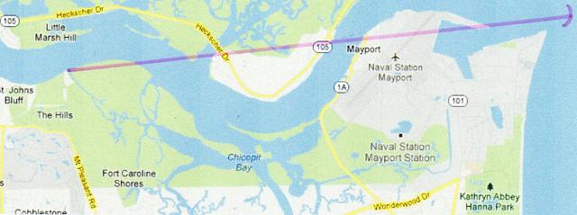
Below, the "line of sight" from St. Johns Bluff's highest elevation (today's Parking lot for the Ribault Pillar Monument) to the Bar (Spanish Barra, olde English Barre of Hakylut), the entrance into the St. Johns River in 1856. Laudonniere (1565) said that the French relief fleet had anchored outside the Bar and one of his men atop a tree on a "small hill" could see seven smaller boats crossing the Bar. I have rendered the Bar Entrance with a red slash mark.
Below, an aerial photo of St. Johns Bluff in 1943. I have in black marker labeled the valley ringed by forested hills where I suspect the "Vale of Laudonniere" existed, a flat area possessing "meadows of grass and streams, excellent for raising cattle" according to Laudonniere.
"...wee discovered a little hill adjoyning unto a great vale very greene and in form flat; wherein were the fairest meadows of the world and grass to feede cattel. Moreover it is invironed with a great number of brookes of freshwater, and high woods, which make the vale more delectable to the eye...I named it at the request of our souldiers, the Vale of Laudonniere..." (pp. 15-16. Richard Hakluyt. The Principal Navigations, Voyages and Discoveries of the English Nation. Vol. IX. Glascow. James MacLehose and Sons. Publishers to the University. MCMIV [1904])
Today's Fort Caroline is suppossed to be a scaled down model of the orignal fort. The problem? The fort's dimensions are not given. However the French did construct another triangular fort at Port Royal (later called by the Spanish St. Elena) in South Carolina and its dimensions were preserved, 66 paces or 130 feet, so perhaps Fort Caroline was of a similar dimension?
"...Nicolas Strozzi sailed in Le Prince in the spring of 1576...There is little doubt that Le Prince's presence off the La Florida coast was part of a larger design resembling the French colonial ventures of the early 1500s...Whatever Strozzi's objective, his shipwreck at Port Royal Sound led him and his crew to construct a triangular fort of earth and faggots, with corner bastions. They erected five buildings inside the enclosure, which was about 130 feet on a side (sixty-six paces). The Spaniards found one piece of bronze artillery weighing 1200 pounds. An early report said that 280 men had been in Le Prince's crew, of whom the Indians killed two hundred when they attacked the fort..." (p. 278. "The Contest for Empire in the Southeast." Paul E. Hoffman. A New Andalucia and a Way to the Orient: The American Southeast During the Sixteenth Century. Reprint of 2004. Louisiana State University Press. 1990)
Below, my rendering (tracing) of Le Moyne's 1565 Map (published 1591 by DeBry) overlaid with my annotations and tentative proposals for sites. Of importance to me is landforms 1 through 7, which when aligned with simialr landforms on the 1791 Map reveal that the location of Fort Caroline is at today's St. Johns Bluff between St. Johns Creek and Shipyard Creek.
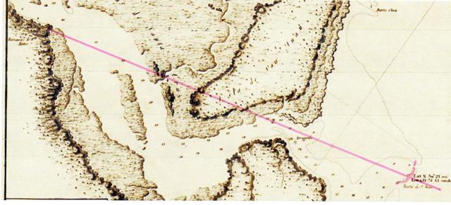
Below, line of sight (pink marker) from St. Johns Bluff (1737 and 1809 Spanish Maps: Barrancas de San Mateo, "Bluffs of San Matheo") to the Barra de San Juan, which is shown as being at 30 degrees 21 minutes North Latitude (Map of 1809, made in Madrid, Spain. Titled Boca y Barra Rio de San Juan). Hakylut's olde English rendered todays Bar as Barre, with two r's, like the Spanish Barra. Outside the Barra French ships anchored whose draft was too deep to enter the shallow waters of the St. Johns River. Fortunately, some ships (three) were of a shallow draft and were able to anchor across from Fort Caroline at St. Johns Bluff. The unprotected anchorage outside the Barre/Barra was called in English "the Road." The 1856 map shows the Bar to be at 30 degrees 20 minutes (in alignment with the lighthouse). In 1565 Pedro Menendez de Aviles, the Spanish conqueror of Fort Caroline, ordered his men to fix the location of the fort via a reading of the sun's height, and he said the fort was located in 30 and a quarter degrees (Bennett, 1964, in error, mistranslated the Spanish as 31 degrees). One degree is 60 minutes, half a degree is 30 minutes, a quarter degree is 15 minutes, so De Aviles' 30 and a quarter degrees works out to 30 degrees 15 minutes (30.15 North) for the location of Fort Caroline (Spanish Fuerte de San Mateo). The English sea captain who visited the fort in 1565 said "...the Frenchmen abode at 30 and a half degrees,..." which would place Fort Caroline at 30 degrees and 30 minutes (today's 30.30 North). Today (14 October 2020) the National Park Service's Fort Caroline and Timuacan Preserve is listed by Google on the internet as being at 30.3854 North. I note that Hawkins said the fort was at 30 degrees 30 minutes, which just a few fractions of a degree off from the present (2020) degree reading for Fort Caroline, almost spot-on! At 30 degrees 15 minutes (today's 30.15 North) Fort Caroline would be on a parallel with Ponte Vedra Beach in Florida (see Map 58. Florida Atlas & Gazetter. Delorme. Freeport, Maine. 1997). I admit to being "stunned" by Hawkin's 1565 accuracy for the Frenchmen's "abode" (Fort Caroline) being at 30.30 North and today's Fort Caroline Park being at 30.3854 North)!
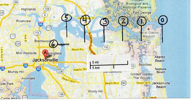
Below, a Google map (5 mile scale). I have divided in half the scale to 2 1/2 miles to approximate one league being 2.6 miles with calipers. Within circles I have counted off the number of leagues from the mouth of the St. Johns River (The May River of 1564-1565). Each number in its circle represents the leagues from the Sea and mouth of the river to Fort Caroline according to different depositions of the period 1564-1565. This was done to give the viewer some idea of where Fort Caroline might be located according to different witnesses. At (1) one league we are 2 1/2 miles from the river's mouth, (2) two leagues or five miles from the river's mouth we are at St. Johns Bluff, (3) three leagues or 7.8 miles from the river's mouth we are just above Mill Cove Bay, (4) four leagues or 10.4 miles from the river's mouth we are at the Arlington Heights area, (5) five leagues or 13 miles from the river's mouth we are at Arlington, (6) six leagues or 15.6 miles from the river's mouth, we are at Brentwood and Arlington, just north of Jacksonville.
One League:
No one states that Fort Caroline is one league from the mouth of the river.
Two Leagues:
Rene Laudonniere (p. 522. "The Voyage of Rene Laudonniere to Florida." Barnard Shipp. The History of Hernando, Desoto, and Florida, or Record of the Events of Fifty-six Years from 1512 to 1568. Philadelphia. Robert M. Lindsay. 1881) "The brigatine, oppressed with famine, came to anchor at the mouth of the river May...Now they were not more than two leagues distance from the mouth of the river, where they cast anchor, to the fortress."
Stefano de Rojomonte (p. 97. Charles E. Bennett. Laudonniere & Fort Caroline, History & Documents. 1964. 2001)
"Questioned as to in what parts of the said port the site and fort are established, he said that it may be two leagues from the mouth of the said river, at a high hill, which is above one arm of the said river on the southwest bank."
Note: "high hill" in Spanish is rendered barranca alta. A barranca can be a hill, precipce, ravine, or bluff.
John Hawkins (p. 122. cited from John Sparke. The Voyage made by M. John Hawkins Esquire, 1565. Henry S. Burage, editor. Original Narratives of Early American History: English and French Voyages, Chiefly from Hakluyt, 1534-1608. Charles Scribner. New York. 1906). "In this river of May aforesaid, the captain entering with his pinnesse, found a French ship of fourscore ton and two pinnesses of fifteen ton a piece, by her, and speaking with the keepers thereof, they told him of a fort two leagues up, which they had built..."
Nicholas Le Challeux, French survivor of the 1565 Spanish massacre at Fort Caroline, stated the fort was two leagues from the mouth of the May River where additional French ships were anchored:
"The Spaniards...dispatched a messenger to our ships...The lives of the French would be spared if they would abandon their ships and make their way...in small boats to the other ships that were lower in the mouth of the river, about two leagues distant from the fort." (p. 104. "Le Challeux." Stefan Lorant, editor & annotator. The New World, The First Pictures of America Made by John White and Jacques Le Moyne and Engraved by Theodore De Bryy, with contemory narratives of the Huguenot settlement in Florida 1562-1565 and the Virginia Colony 1585-1590. New York. Duell, Sloan & Pearce. 1946. First Edition)
Three Leagues:
Rene Laudonniere (pp. 62, 65. Charles E. Bennett. Three Voyages, Rene Laudonniere. 1975. 2001)
"I had not sailed more than three leagues up the river...when I discovered a mountain of modest height...the sea may be seen clearly and openly from it..."(The fort is later built near this mountain)
Four Leagues:
Robert Meleneche (p. 89. Charles E. Bennett. Laudonniere & Fort Caroline, History & Documents. 1964. 2001)
"They built a fort of timber and faggots, four or five leagues in the mouth of the river past the banks mentioned before..."
Five Leagues:
Robert Meleneche (p. 89. Charles E. Bennett. Laudonniere & Fort Caroline, History & Documents. 1964. 2001)
"They built a fort of timber and faggots, four or five leagues in the mouth of the river past the banks mentioned before..."
Six Leagues:
Stated in an anonymous letter of 1564 from Fort Caroline to a Frenchman's family in France (p. 68. Charles E. Bennett. Laudonniere & Fort Caroline, History & Documents. 1964, 2001)
"The fort is in the said River May, about six leagues up the river from the sea..."
Lowery (1905) on Fort Caroline's location:
"Some confusion exists in the above descriptions, but four of the authorities agree in placing the fort on or near a high hill, and it was unquestionably situated on a river, probably where a small stream flowed into it. It is not at all unlikely that it was at the head of sandbars in the river..."As Dr. Shea has observed, the location at St. Johns Bluff does not altogether satisfy the requirements; but in the course of years the topography of the river may have greatly changed, and St. Johns Bluff cannot be far out of the way..." (pp. 405, 407. Woodbury Lowery. Spanish Settlements Within the Present Limits of the United States, Florida. G. P. Putnam's Sons. New York. 1905)
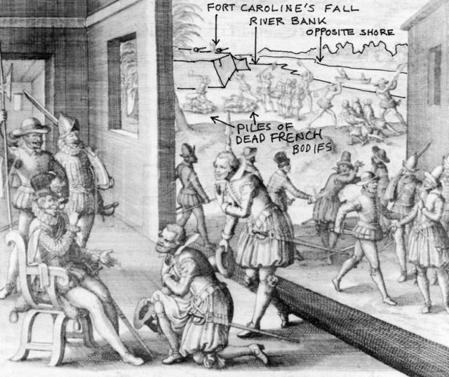
Below, a drawing by Theodore DeBry (published 1591), illustrating "The Fall of Fort Caroline to the Spanish." The King of Spain, Phillip II, is portrayed in his palace, in Spain, receiving an account of the fall of Fort Caroline from his Courtiers. In the background, the fort's wall is shown as near the south shore of the May River (today's St. Johns River) with cannons atop its walls aimed at the river. In the distance, beyond the river is the opposite shore with trees. A small boat with two people in it, is in the river. The Spanish are shown slaying the French, and two piles exist of dead Frenchmen on the river bank as stated in Le Challeux's account. In the foreground is a small hill with a tree atop it. Assuming we are looking west at the fort, perhaps the artist intended the small hill and its tree to be those described in the French account of a "very nearby small hill" being climbed daily to look for ships' sails at the mouth of the river? One account has a tree climbed atop the hill which allows ships at anchor outside the Bar, in the Road, to be seen. A "peculiar arc" is preserved in the shoreline by the fort, is this today's shoreline arc of St. Johns Bluff, from St. Johns Creek to Shipyard Creek? If accurate, the drawing suggests the fort is west of St. Johns Bluff Promontory, on or very near the shore and opposite the shoreline arc. St. Johns Bluff Promonontory might be the small hill and its tree in the foreground, the promontory (in shadow) extending out toward the river's bank in the drawing.
Below, a drawing of Fort Caroline as a White Triangle at the edge of the St. Johns River as imagined by T. Frederick Davis who provided the drawing to Fairlie (cf. p. 84. Margaret Carrick Fairlie. History of Florida. Privately Published. Jacksonville, Florida. 1935). Fairlie was a Principal at Norwood School, in Jacksonville and wrote this book as a teacher's resource in teaching students about Florida history.
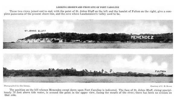
Below, a panorama view in two sections showing the coastline from St. Johns Bluff to Fulton. Davis believed that the fort was west of the area marked Menendez, which is the general area of Spanish Pond. This photo is important in showing the cliff-face of St. Johns Bluff from the river. Most likely Fort Caroline lies near the flatter shoreline, the area west of Menendez in white letters (p. 12. T. Frederick Davis. History of Jacksonville, Florida and Vicinity, 1513-1924. Press of the Record Company. St. Augustine, Florida. 1925. 513 pages).
Below, my map proposal showing LeChalleux's escape route from Fort Caroline to where he was picked up after crossing three large, swift streams in the marshes in 1565, superimposed on a 1917 Topographical map.
Below, note how Saint Johns Creek (viewer's left) encircles St. Johns Bluff on the east and Shipyard Creek encircles the Bluff (the viewer's right) on the west. I suspect that these two creeks are what appear on the above Le Moyne map of 1565 printed in 1591 by De Bry.
Below, engraving showing Fort Caroline being built on what appears to be an island (after LeMoyne 1565, published 1591 by De Bry). This engraving contradicts eyewitness Spanish account of their attack on Fort Caroline. The Spanish said that from a hill they descended upon the fort at the river's edge. No mention of having to cross a stream, creek, river, or a water filled moat. Perhaps the two streams are intended to represent today's St. Johns Creek on the east and Shipyard Creek on the west, of St. Johns Bluff? The island opposite the fort is perhaps today's Little Marsh Island of the 1853 U. S. Coastal Survey Map of the St. Johns River?