Fort Caroline and the Barra
(Viewing the Mouth of the St. Johns River)
Walter R. Mattfeld, M.A. Ed.
Orange Park, Florida 32073
26 June 2013, revisions through 15 August 2014
I welcome comments/corrections on this article via
the following email link:
The 1791 map (drawn up in St. Augustine) showing the area of St. Johns Bluff noted in Spanish the existence of a pequena altura, a "small height" from which one could "see as far as the Barra." Spanish Barra (1791) is olde English Barre (1500s) and modern English's Bar, alluding to the mouth of a river where it meets the sea, said entrance usually flanked by sand bars which must be navigated through, hence: barra, barre, bar.
A few months ago (February of 2013) I stood at this location, which I have identified as today's Ribault Monument parking lot and its viewing platform of the river, and was dissappointed in not being able to see the mouth of the St. Johns River. This anomaly troubled me, "Was this the correct location" as noted on the 1791 map?"
Reflecting upon this anomaly over the past few months (February-June 2013) it finally dawned on me that I had been at the correct location. I now know why I could not see the river's mouth.
A 1917 topographical map shows the area to be 80 feet high at St. Johns Bluff (scale: 1:62,500).
A 1950 topographical map shows the highest point of the bluff to be 86 feet, marked by a triangle (scale: 1:24,000), yet, "strangely," the contour line for this elevation is 70 feet, not 80 feet. Is it possible that the 86 feet is a "typo-error"? Was 76 feet intended as there is no 80 foot contour line?
A 1964 topographical map, showing the circular Ribault Monument parking lot, renders this area as being 70 feet in height according to the contour line (scale: 1:24,000).
Apparently the building of the parking lot required bulldozers to level this area in preparation for the laying down of asphalt, stripping away roughly 16 feet of elevation?
Wouldn't it be nice if the Park Service would erect a viewing tower some 16 feet in height at the parking lot to enable viewer's to see what Fort Caroline's French sentinels could see 1564-1565, and Spanish sentinels saw in 1791, the mouth of the St. Johns River and its Barra/Bar entrance? This tower could be erected in commemoration of the 450th anniversary (2014) of the founding of Fort Caroline in 1564 by the French and a plaque could be made to adhere to the tower explaining the view from this site from 1564 to 1791.
One French account (1565) stated that a French sentinel was ordered to climb a tall tree to get a better view of the French ships that had anchored outside the Bar. He climbed the tree and said he could see small boats crossing the Bar while the larger ships remained at anchor, their drafts being too deep for the shallow waters of the St. Johns River. Telescopes were not invented until the 1600s so what he saw was via the naked eye. Assuming the tree was 20-30 feet in height, perhaps the proposed tower should be 36/46 feet in height for a truly stunning view of the St. Johns River's Bar?
All this is to say, dear reader, that today, one cannot see the mouth of the St. Johns River and its Bar/Barra/Barre as was possible in 1565 and 1791 (and 1950?).
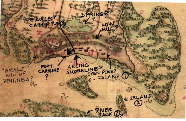
Below, the 1791 map showing St. Johns Bluff area. I have added in black marker my comments which are proposals for the location of Fort Caroline of 1564-1565.
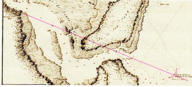
Below, A Spanish map of 1809 showing the St. Johns River (Rio de San Juan) from the area of St. Johns Bluff (Barrancas de San Mateo on the map) to the Barra marked in pink marker whose mouth is shown on the map to be North 30 degrees and 21 minutes (the 1998 Delorme Florida Atlas & Gazetteer gives this location as being at North 30 degrees and 24 minutes)
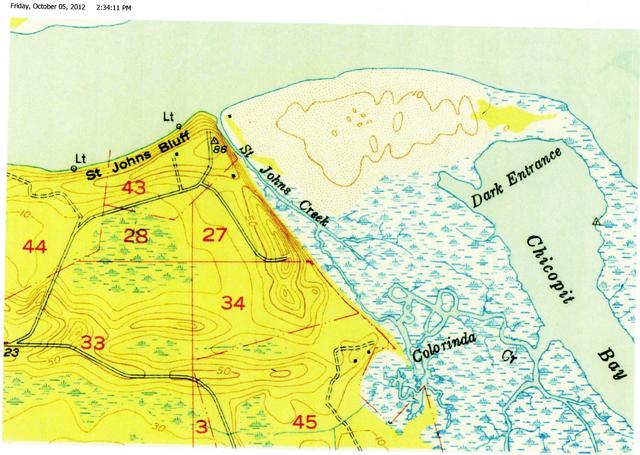
Below, a 1917 (1;62,500 scale) Topographical map titled Mayport, showing St. Johns Bluff to be 80 feet in elevation. This map shows to left of the number 28 a depression or hollow, perhaps this is the "spring" of freshwater for Fort Caroline (Spanish Fort San Mateo) appearing in French and Spanish accounts? The water of the St. Johns River was undrinkable, being brackish, a mix of saltwater from the Ocean and of freshwater from the river. This brackish water extends all the way to Lake George, south of Palatka. The French settlement of Fort Caroline would need access to drinking water, and thus the importance of the "Spring" they found in the woods atop the hill opposite the fort. Later, they could use rain barrels to catch rain water in or dig cisterns to collect rain water.
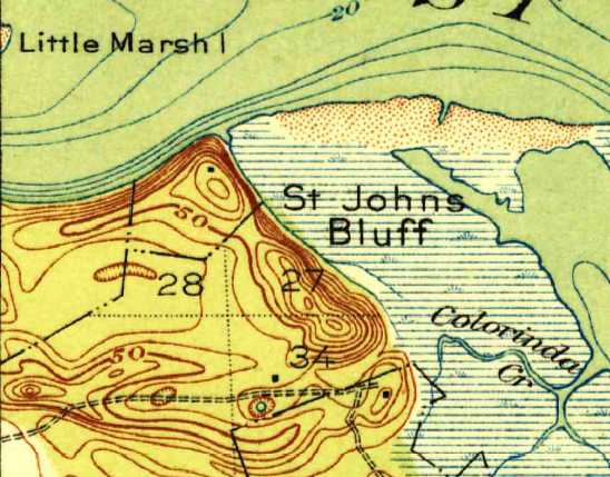
Below, a 1950 Topographical map (1:24,000 scale) titled Mayport, showing St. Johns Bluff to be 86 feet high (the triangle), but "strangely," the contour line is 70 feet, not 80 feet for this elevation. Is this a "typo-error," was 76 feet intended, _not_ 86 feet? Could the prescence of the road indicate that the area was bulldozed down to 70 feet to accomodate the road from the above 1917 map's contour line of 80 feet? As the 1917 map does not have a 90 foot contour line did the surveyors make a note that the highest elevation, under, 90 feet, was 86 feet, come to be not noted on the 1917 map but added, in error, to the 1950 map which preserves a contour of 70 feet instead of 80 feet? In other words, the 86 feet should have been on the 1917 map not the 1950 map? The 1917 map's hollow west of number 28 is not preserved on this map, instead a much larger area is shown as a marsh. Perhaps this anomaly explains why the French accounts of 1565 alternately call this a "spring" and a "marsh"? That is to say at times of low water the 1917 hollow is a spring, but after hurricane rains it overflows to become a marsh-area, the marsh Menendez's soldiers waited in overnight before crossing a hill ridge to attack the French Fort in 1565? This map also shows two areas of marsh at numbers 28 and 33. Perhaps these two marshes are what appear on the 1791 map?
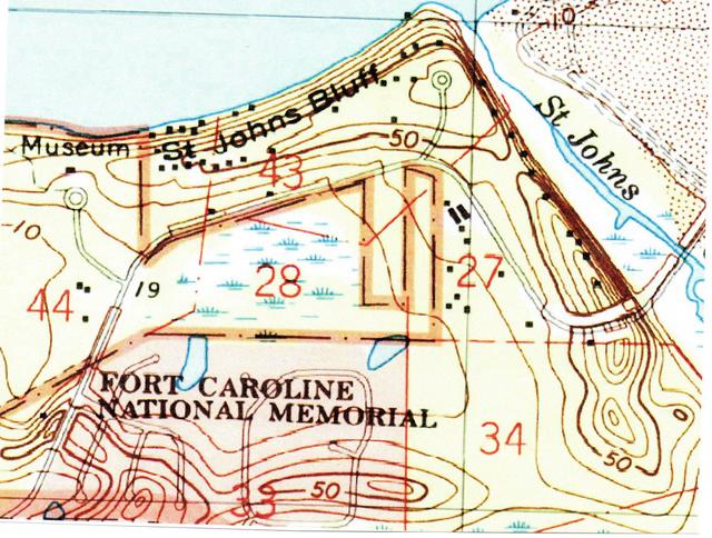
Below, a 1964 Topographical map (1:24,000 scale) titled Mayport, showing the Ribault Monument Parking Lot (shown as a cul-de-sac) to be within a 70 foot contour line, not an 80 foot contour line.
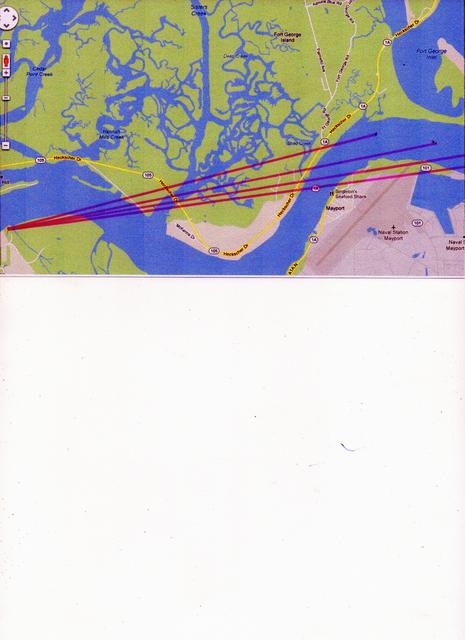
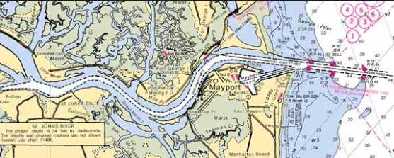
Below, Today's St. Johns River from St. Johns Bluff to Mayport Naval Station, my red marker showing possible line of sight views in 1565 and 1791.
Below are links to four additional articles I have written on the whereabouts of Fort Caroline:
Below, a map (2014) showing the dredged-out ship's channel (in white) from the Atlantic Ocean to the St. Johns Bluff area (the mouth of the St. Johns River is given as being N.30.39691 degrees). The 8 French ships which sunk in 1565 could have been destroyed and removed by such dredging and may lie in pieces today as land fill aong the banks of the St. Johns River? One ship was sunk by cannon fire from Spanish captured Fort Caroline, the others sunk in the mouth of the river where they were at anchorage. Four were destroyed in a hurricane, three were scuttled by the French to avoid their falling into Spanish hands.