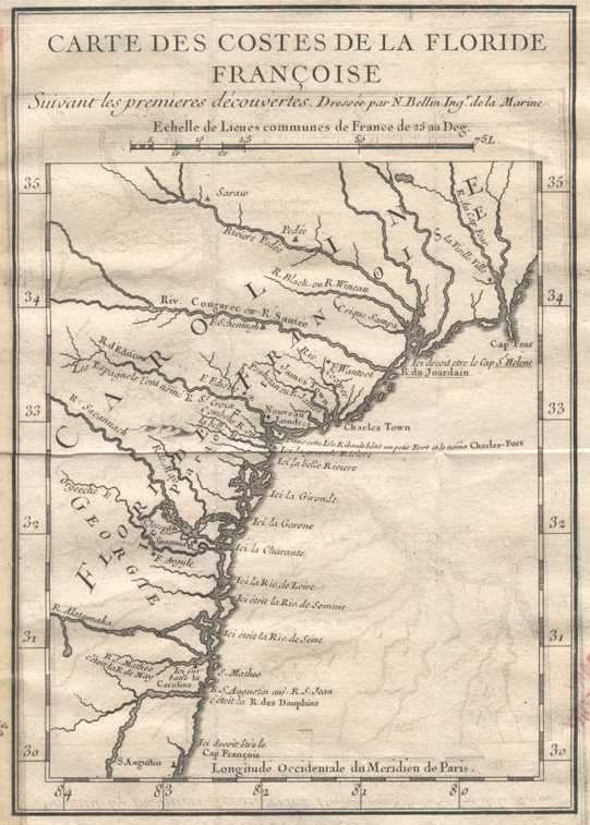
Below, a map by Jacques N. Bellin, circa 1744, "Map of the Coasts of French Florida," showing today's (2013) St. Johns River is labeled R. S. Augustin or R. S. Juan, or R. des Dauphins. The port of St. Augustine is south of this river. North of this river is the R. S. Matheo/ R. May (today's St. Marys River), north of it is the Alatahama River (in Georgia). Fort Caroline (Ici le Caroline) is shown as being on the southside of the R. S. Matheo (River of San Mateo) and north of the mouth of today's St. Johns River. On this map the San Matheo/Mateo River is at approximately 31 degrees north. The San Juan (St. Jean) River is just south of the map's S. Mateo and Fort Caroline and is shown at about 30 1/2 degrees (30 degrees 30 minutes) north (today it is at 30 degrees and 24 minutes North). San Augustine is incorrectly shown at just under 30 degrees north (Today it is at 29 degrees 55 minutes North).
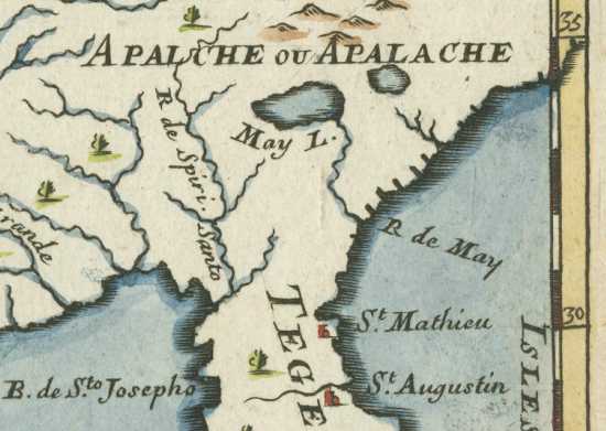
Below, a 17th century map showing the settlement of St. Mathieu, Spanish San Mateo (but not the San Matheo River) north of St. Augustine, is south of the R de May (May River) which is shown flowing from Lake May (May L.) in the Apalche or Apalache mountains of present-day Georgia. St. Mathieu (Spanish: Fuerte de San Matheo) is correctly shown at approximately 30 degrees north. St. Augustine is correctly shown at approximatedly 29 degrees north. The River May is at approximately 32 degrees north on this map, (de Aviles' 1565 statement said it was 30 and 1/4 degrees north). Errors: The River of May (Spanish: Rio de San Matheo, later Rio de San Juan) drains from lakes in the south of Florida, not a lake in Georgia's Appalachian Mountains.
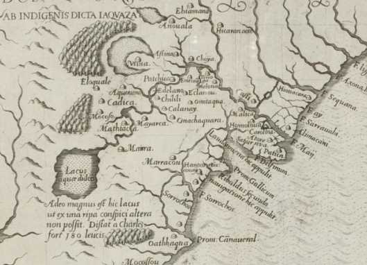
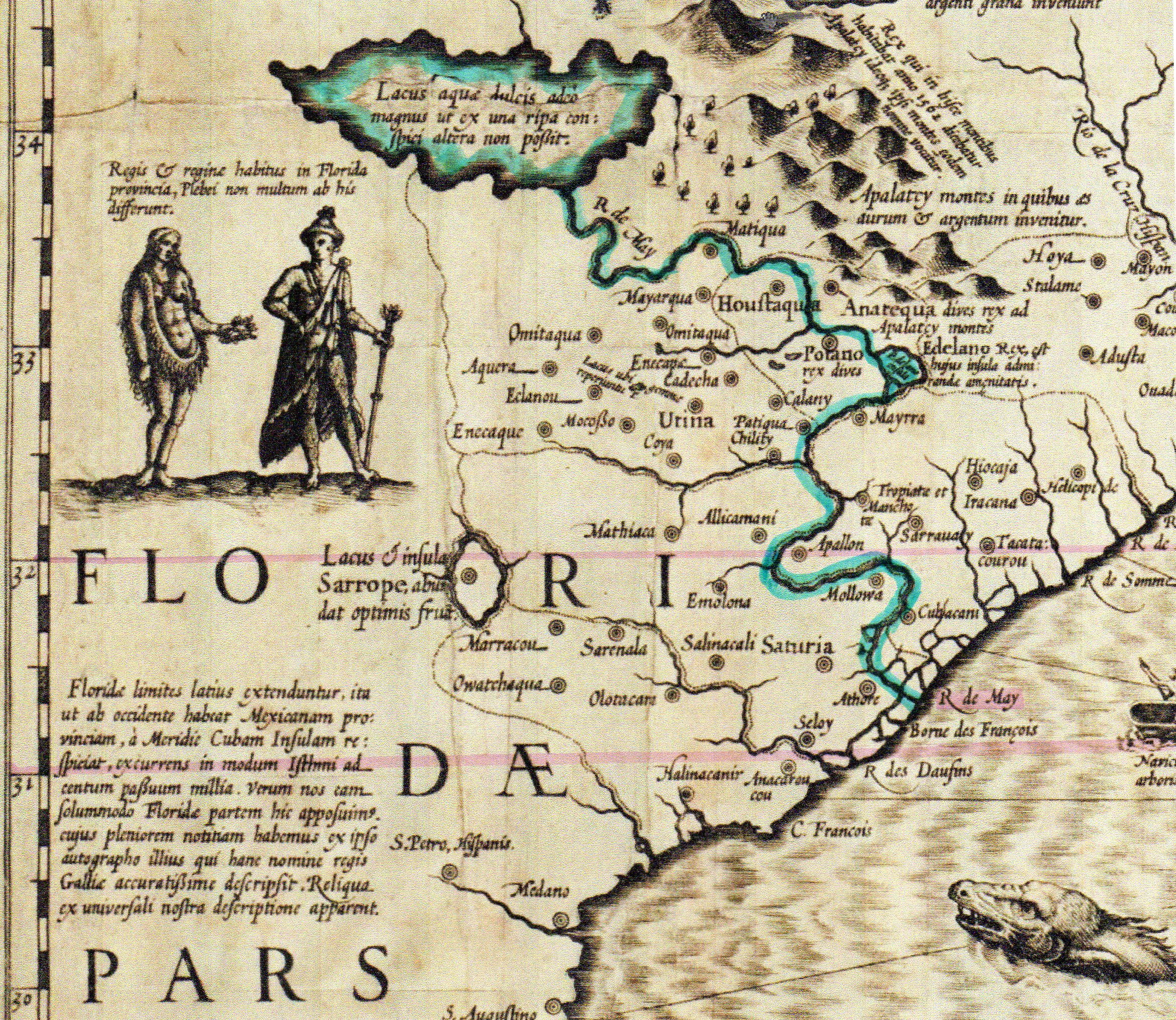
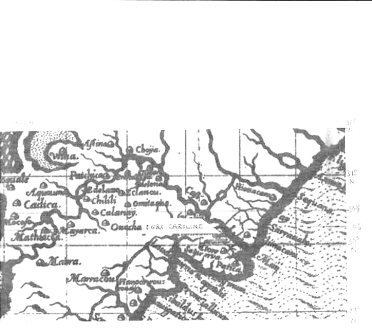
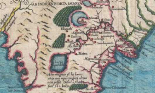
Below, a map made circa 1575, by Juan Lopez de Velasco, Spanish Cartographer and Historian under Philip 2 of Spain. Map title: Demarcacion y Diuision de las Yndias. The above map was copied from the 1575 map by Antonio de Herrera y Tordesillas in his Historia general, Madrid, 1601. The mouth of Rio de San Mateo is north of Rio de Mosquito (an Inlet south of St. Augustine which is not on this map), south of Mosquito is Rio de Matanzas (another Inlet), further south is Cape Canaveral (not on this clipped version of the map). An error exists: Where Mosquito Inlet exists it should read either San Augustine or Rio de Florida. This error is reproduced on the above 1601 map, that is to say Mosquito should be south of Matanzas, not north of it, according to later maps. In 1565 French Fort Caroline on the May River fell to the Spanish who renamed it Fuerte de San Matheo. The French river May was renamed Rio de San Matheo, and still later Rio de San Juan, then St. Johns. In 1568 the fort was burned down by the French in reprisal for the Spanish capture of it in 1565. The Spanish rebuilt the fort, but are believed to have abandoned it by 1570. However when Sir Francis Drake attacked St. Augustine in 1586 some of the inabitants fled to San Matheo. This suggests for me that the settlement of San Matheo may have existed as late as 1586. So this map, made in 1575, was created 11 years before Drake destroyed St. Augustine! My thanks to Dr. Fletcher Crowe for a copy of the 1575 map. The below map shows Rio de San Matheo to emerge from a lake (today's Lake George) west of Rio de Matanzas, it then flows north, to the west of Mosquito, before entering the Atlantic Ocean. Only today's St. Johns River matches this map's configurations of a river arising from a lake west of Mosquito and Matanzas. This map refutes the notion that the Altahamah in Georgia or the St. Marys on the Georgia-Florida border is the river May/San Matheo.
Below, a map circa 1764, by Jacques Nicolas Bellin, showing today's St. Johns River is labeled in French as the River of St. Mathieu or Saint Jean (French St. Mathieu is Spanish San Mateo, French St. Jean is Spanish San Juan). Fort San Mateo doesn't appear on the map. Bellin has _removed_ the May River between the St. Johns (R. de San Augustin) and the Alatahama River (Riv. George) which appeared on the earlier, above map and _corrected his earlier error_, now showing the May/San Mateo River to be where is today the St. Johns River. Bellin's below map shows the mouth of the San Juan (St. Jean) River to be 30 degrees 35 minutes. The reading on a Spanish map of 1809 was 30 degrees 21 minutes.
Maps showing the French Huguenot Fort Caroline of 1564-1565 and the May River it was on as being between 31 and 32 Degrees North in Present day Georgia.
Walter R. Mattfeld, M.A. Ed.
Orange Park, Florida 32073
Corrections and comments are welcomed via email contact: wrmattfeld411@gmail.com
07 January 2013, Revisions through 28 August 2016
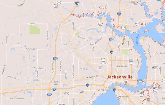
These maps accompany my research on establishing the location of Fort Caroline (1564-1565) at today's St. Johns River west of the Ribault Pillar Monument on St. Johns Bluff. Please click here for that article.
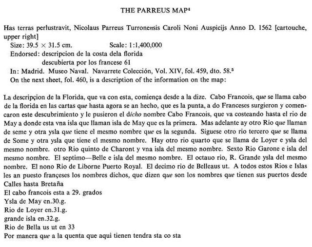
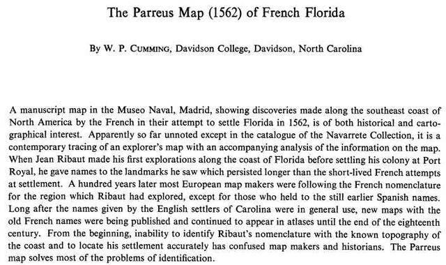
The earliest known and detailed map of the May River is called by scholars "The Parreus Map of French Florida (1562)," (Scroll to the bottom of this page for the map) believed to be made in that year by a Frenchman, a pilot called Nicholaus Barre, who was part of the 1562 expedition (Cumming assumes Parreus is a Spanish misspelling. See W. P. Cumming. Davidson College, Davidson, North Carolina. "The Parreus Map 1562 of French Florida." Imago Mundi. Vol. 17, 1963. pp. 27-40. Available for downloading via subscribing institutions, at the online JSTOR archive). This map is understood to be a Spanish copy of a French map. It resides in the Naval Museum Archives at Madrid Spain. It shows French Florida to be an area from 29 degrees to 34 degrees north. Across the map's bottom degrees are written starting at the viewer's left: 30, 31, 32, and 33. The map's bottom is east, its top is west, its left side is south, and its right side is north.
The Lemoyne map (1565) published in 1591 by DeBry, shows the May River's mouth at the Ocean to be bisected at 30 degrees north latitude and it is shown as flowing from a lake in the south of Florida (probably today's Lake George). As noted, the 30 degree line passes slightly above the mouth of the May River where it meets the Atlantic Ocean, and this line then passes under Caroline (Fort Caroline) which appears on the south bank of the May River.
In 1565 after the fall of Fort Caroline to Pedro Menendez de Aviles, he ordered his men to take a reading of the fort's position on land by the sun. They reported that the fort lay at 30 and one quarter degrees. I drew parallel lines in red marker on the 1562 Parreus map at 30 degrees and then at 30 l/4 and 30 1/2 degrees. To my surprise the 30 1/4 degree parallel line intersected the May River at its south bank, aligning with de Aviles' comment that the fort was at 30 1/4 degrees! (Scroll down to the bottom of this page for the map)
The Parreus 1562 map like the 1565 Le Moyne Map not only shows the May River to be near the 30 degree parallel, both also agree in showing the May River flowing from a lake, to the south west of the river's mouth. On the 1562 map this lake is west of Cabo Francois (Cape Francis) while on the 1565 map the lake is west of Cabo/Cape Canaveral. Pedro Menendez de Aviles stated that the May River which he renamed the San Mateo River, flowed from the south west, his statement aligns May River appearing on the 1562 and 1565 maps. These two maps also show a second river from the north west joining the May where it turns to the south west. Cumming (1963) understands this is today's Trout River (at Jacksonville), I had independently come to the same conclusion from my 2014 study of the 1565 map.
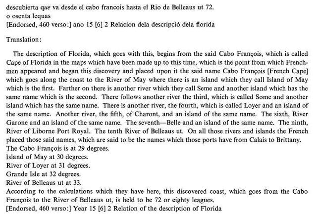
The Parreus map has a second sheet accompanying it, written in Spanish, explaining the map's features in some detail. The "May island" on the map (today's Amelia Island according to Cumming, but I would suggest it is today's Fort George island (Baffin Island on the 1853/1856 St. Johns River of the U. S. Coastal Survey Map, on the 1702 Colonel Moore map it is called Isla de San Juan, the May being called Rio de San Juan) is stated to be "in or at 30 degrees." The LeMoyne map of 1565 shows an island in the midst of the May River near its mouth, could this be the submerged sand bar on the 1853 U.S. Coastal Survey Map of the St. Johns River, assuming it was eroded away after 400 years, or is it alluding to Great Marsh Island? The Parreus Map shows the Rio de Loyer (French: Loire Riviere) "in 31 degrees." Of interest here, is that several individuals of late (2012-2014), have proposed Fort Caroline and its May River are the Altahamah River in Georgia, located at 31 degrees 19 minutes north. The 1562 and 1565 maps clearly show the May to be at 30 degrees not 31 degrees, and the Spanish explanation sheet says that May Island (today's Fort George Island?) is in (en) 30 degrees while the Rio de Loyer/Loire River is in (en) 31 degrees. The 1562 Map's Spanish notations would seem to discredit the claim that the May River and Fort Caroline are in Georgia and in the Altahamah River area (said claims being made by Richard Thornton, 2012-2014 on the internet, and Drs. Fletcher Crowe and Anita Spring in 2014 at Tallahassee).
Yet, for some 200 years Fort Caroline and the May River, were, in error, frequently shown on maps to be between 32 and 31 degrees north in today's state of Georgia on what is today the Altahamah River. It was these later maps' errors that caused some to believe that Fort Caroline and the May River were in Georgia.
I understand that the captured Frenchman Stefano de Rojomonte (28 January 1565) gave Fort Caroline's location to Spanish authorities at Havana as being 31 degrees north when it fact it was nearer 30 degrees north, to protect the settlement from being attacked and destroyed by Spanish who would seek it at the wrong location (one degree of latitude being 60 nautical miles today).
Both the French survivors of the Fort Caroline massacre of 1565 and the Spanish who slew them, knew that the May river did not descend from the Appalchian mountains of Georgia, its headwaters were a south Florida lake, today's Lake George (as noted in their accounts). For example Pedro Menendez de Aviles who captured Fort Caroline said the river it was on flowed from the vicinity of the Bay of Juan Ponce. Spanish maps locate this bay near today's Port Charlotte, in southwest Florida.
In 1565 the French fort fell to Pedro Menendez de Aviles of Spain, who, after its fall to him, had one of his men establish its location from a reading of the sun by a sextant at 30 and one quarter degrees north. The contemporary (1565) accounts state that the distance from St. Augustine to Fort Caroline was estimated at either 5, 8, 10, or 15 leagues. A league is the distance a man can walk in one hour, roughly 2.6 miles. At 15 leagues Fort Caroline and its May River would be 39 miles north of St. Augustine. Today (2013) it is 39 miles from Mayport at the mouth of the St. Johns River, to St. Augustine. So it is impossible that Fort Caroline and the May River were at Rojomonte's 31 degrees north, which would be today's St. Andrews Sound south of Brunswick, Georgia, 100 miles away from St. Augustine
Menendez in a 1565 letter to King Phillip II of Spain, which Bennett, _in error_, translates as 31 degrees, states Fort San Mateo (French Fort Caroline) was 30 and a quarter degrees (brackets [ ] are mine). Note: St. Augustine is today (2013) at 29 degrees 55 minutes North Latitude. A half degree is 30 minutes, so Menendez is saying St. Augustine is 29 degrees 30 minutes. The instruments available in the 1500s to reckon minutes and degrees of latitude were inaccurate by today's standards. Today at 29 degrees 30 minutes St. Augustine would be near Flagler Beach (north of Daytona Beach).
"This port [Saint Augustine] is 29 1/2 degrees, and the San Mateo which we captured is 31 degrees. The French and their pilots were mistaken. I have had it taken by the sun on land." (p. 137. Charles E. Bennett. Laudonniere and Fort Caroline, History and Documents. University of Alabama Press. Tuscaloosa and London. 2001. 1964, University of Florida Press)
Lowery (1905) quotes Menendez in Spanish and Menendez said the fort was in 30 and a quarter degrees, _not_ 31 degrees as related, above, in error, by Bennett (1964). At 30 and a quarter degrees or 30 degrees 15 minutes Fort Caroline would be at today's Ponte Vedra Beach. The mouth of the St. Johns river is today just below 30 degrees 25 minutes. Note: My brackets [ ] which translate into English the Spanish reading:
"El [puerto] del fuerte de Sant Mateo que ganamos esta en [in] treynta [thirty] y [and] un [a] quarto [quarter]; porque los franceses y sus pilotos se enganavan, e yo he hecho tomar el sol en tierra y averiguario." (p. 390. Woodbury Lowery. The Spanish Settlements Within the Present Limits of the United States, Florida, 1562-1574. G. P. Putnam's Sons. New York and London. 1905)
The Spanish historian Juan Lopez de Velasco (circa 1530-1598) apparently repeated Menendez's degree reading for Fort Caroline (Fuerte San Mateo) and the River of San Mateo (French: May River):
"Desde la dicha punta al rio de San Mateo va la costa al nornorueste, declinando algo al norte, hasta el rio de San Mateo, que esta en 30 grados y 1/4..." (p. 168. Juan Lopez de Velasco, Geografia Y Descripcion Universal de las Indias. Desde el Ano de 1571 al de 1574. Editor: Don Justo Zaragoza. Madrid 1894. La Real Academia de la Historia)
Juan Lopez de Velasco (1530-1598) understands Saint Augustine (San Agustin) lies in 29 and three quarter degrees (29 degrees 45 minutes):
"La punta de San Agustin, que es donde esta el fuerte de los espanoles arriha descrito, esta en 29 grados y 3/4, veinte y dos leguas del rio de Mosquitos..." (p. 167. Juan Lopez de Velasco. Geografia y Descripcion Universal de las Indias, Desde el Ano 1571 al de 1574. Editor: Don Justo Zaragoza. Madrid. La Real Academia de la Historia. 1894)
Antonio de Herrera y Tordesillas (1600) locates Saint Augustine at 29 and three quarters degrees (29 degrees 45 minutes and the river of San Mateo is 10 leagues from St. Augustine):
"...el rio los Mosquitos, antes del rio de la Matanza, que se llama asi por la que hizo Pedro Melendez en el capitan Juan Ribao y sus francesceses, y la punta de San Austin, en veintinueve grados y tres cuartos; y de alli diez leguas el rio de San Mateo..." (p. 52. Antonio de Herrera y Tordesillas. Descripcion de las Indias Occidentales. 1600. Madrid)
The English Privater, Master John Hawkins visited Fort Caroline in 1565 shortly before its fall to the Spanish and Menendez. His pilots reckoned the mouth of the May River to be in 30 degrees and better, and in 30 and a half degrees, not very far off the mark from Menendez's 30 and a quarter degrees!
Hawkins (1565):
"...he found them, who inhabited in a river called May, standing in 30 degrees and better." (p. 120. Cited from John Sparke. The Voyage made by M. John Hawkins Esquire, 1565, in Henry S. Burrage, editor. Original Narratives of Early American History. English and French Voyages, Chiefly from Hakluyt, 1534-1608. Charles Scribner. New York. 1906)
"...they kept on their way along the coast of Florida, and on the 15th day came to anchor, and so from 6 and 20 degrees to 30 and 1/2 degrees, where the Frenchmen abode." (p. 119. cited from John Sparke. The Voyage made by M. John Hawkins Esquire, 1565, in Henry S. Burrage, editor. Original Narratives of Early American History, English and French Voyages, chiefly from Hakluyt, 1534-1608. Charles Scribner. New York. 1906)
Today (2013) one degree of Latitude is reckoned as 60 nautical miles, so 1/2 a degree would be 30 nautical miles and a quarter degree would be 15 nautical miles (cf. Coastal Navigation.com, accessed 02 March 2013). Today Saint Augustine is at 29 Degrees 53 Minutes, while the U.S. Navy's Mayport at the mouth of the St. Johns River is at 30 Degrees 24 Minutes.
For unknown reasons, _later_ (after 1562 and 1565) French cartographers portrayed their country's claims as lying between the 31 and 32 degrees north, placing the area in today's state of Georgia. As will be seen below, the maps vary wildly amongst themselves as to where the May River was to be sited and its Fort Caroline. Thankfully, most maps while misslocating the May River in Georgia, did often-times correctly preserve the San Mateo River as just north of St. Augustine at approximately 30 degrees north. The Spanish conqueror of Fort Caroline renamed the fort and river San Mateo as he captured it on the Catholic feast day of St. Matthew. Later the San Mateo River would be called the San Juan River after the Spanish mission of San Juan de la Puerta at the mouth of the river on its north side. The English would call it the St. John's River, the Americans would drop the apostrophe and call it the St. Johns.
To sum up this research in a nutshell, I came to conclude that several confusions were behind the mistaken belief that Georgia was where Fort Caroline and the May River were at on some maps.
Confusion 1)
The captured Frenchman Rojomonte may have deliberately given false information about the whereabouts of Fort Caroline and its May river in order that their Spanish enemies would not be able to find the settlement and destroy it.
Confusion 2)
In a letter to the King of Spain, Philip II, Pedro Menendez de Aviles, the Spanish conqueror of Fort Caroline in 1565, stated that he had his men record the fort's latitude after its fall to him and it was 30 and a quarter degrees (north) (cf. p. 390. Woodbury Lowery. The Spanish Settlements Within the Present Limits of the United States, Florida, 1562-1574. G. P. Putnam's Sons, New York and London. 1911), declaring that the French were "wrong" in their latitude reckoning for this site. He did not state in his letter what the French reckoning was, but a captured Frenchman, Stefano de Rojomonte (a mutineer from Fort Caroline) at Havana, Cuba in a deposition sworn to before Spanish authorities said the French fort was at 31 degrees north. This deposition is dated 28 January 1565. Pedro Menendez de Aviles captured the fort on 20 September 1565, eight months after Rojomonte's sworn deposition. I suspect Menendez's statement about the French pilots being "wrong" about the degree reading for Fort Caroline and its May River is probably referring to Rojomonte's deposition which might have been passed on to him before he left Spain by the Spanish authorities in Havana. It may be that Rojomonte deliberately gave false information about the true location of Fort Caroline to protect his French comrades from a later Spanish attack. Of interest here is that a number of later maps produced by French cartographers located the French-American border at 31 degrees north (thereby placing it in today's state of Georgia).
Not all Frenchmen located the May River and Fort Caroline at 31 degrees north like Rojomonte,
Ribault (1562) said that the May River was _in_ 30 degrees north:
"The next morning we returned to land again...carrying with us a pillar or column of hard stone, with the king's arms engraved thereon, to plant and set the same at the entry of the port, in some high place, where it might be easily seen...The situation is in thirty degrees north latitude...The next day, being the 3rd of May (1562), being desirous to find out harbors to anchor in, we hoisted sail again, and after we had ranged the coast as near shore as we could, there appeared to us about seven leagues on this side of the river May, a great opening or bay of some river, whither we sent one of our boats and found one entry almost like the river May..."
(pp. 176, 179. B. F. French. Historical Collections, Louisiana and Florida, including translations of original manuscripts relating to their discovery and settlement with numerous historical and geographical notes. Historical Memoirs and Narratives, 1527-1702. Albert Mason, Publisher. New York. 1875)
Le Moynes' 1565 map published in 1591 by DeBry shows the May River to be at approximately 30 degrees North Latitude (it lies just north of the 30 degrees latitude line).
The mouth of the St. Johns is today (2013) calculated at 30 degrees 24 minutes north. The English Privateer John Hawkins visited Fort Caroline in 1565 and calculated it to be at 30 and 1/2 degrees north. Pedro Menendez de Aviles upon capturing it on 20 September 1565 said it was 30 and a quarter (degrees north).
Rojomonte's 31 degrees:
"Questioned as to when they had arrived in Florida...he said that they had departed France two months ago, had arrived at the coast of Florida without touching any other land, and had entered a stream which they call the River of May which is, according to what they say, at 31 degrees latitude, and that they jumped on land there and built a fort of earth and faggots...in it they had put seven pieces of artillery and the ammunition and provisions...with roughly 200 men." (p. 95. Charles E. Bennet. Laudonniere and Fort Caroline, History and Documents. Reprint of 2001)
Menendez, who captured Fort Caroline, said it lay at 30 and a quarter degrees north. In error, Bennett misread 31 degrees!
Bennett (1964), in error, having Menendez claim Fort Caroline is at 31 degrees north latitude (brackets [ ] are mine, to show the letter was written at St. Augustine):
"This port [San Augustine] is 29 1/2 degrees, and the San Mateo which we captured is 31 degrees. The French and their pilots were mistaken. I have had it taken by the sun on land." (p. 137. Charles E. Bennett. Laudonniere and Fort Caroline, History and Documents. University of Alabama Press. Tuscaloosa and London. 2001. 1964, University of Florida Press)
Lowery (1905), citing from Spanish documents:
"Menendez, in his "Carta al Rey, 15 de Octubre de 1565" (Ruidias, La Florida, tomo ii., p. 92), says..."El [puerto] del fuerte de Sant Mateo que ganamos esta en tryenta y un quarto; porque los franceses y sus pilotos se enganavan, e yo hecho tomar el sol en tierra y averiguarlo." (p. 390. Woodbury Lowery. The Spanish Settlements Within the Present Limits of the United States, Florida, 1562-1574. G. P. Putnam's Sons. The Knickerbocker Press. New York and London. 1905)
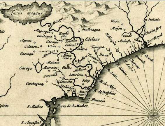
Below, the 1565 Jacques Le Moyne map, written in Latin, published circa 1591 by DeBry, correctly shows the source of the May River R. de Maii (today's St. Johns River) to be a lake, Lacus Aquae Dulcis "Lake of Sweet Water," probably today's Lake George, to the SW of the river's mouth; the May River and Fort Caroline (Carolina) are correctly located at just a little bit north ( or, as the French said it lies _in_ 30 degrees) of 30 degrees north.
Below, a French map circa 1683, by A. M. Mallett, showing the May River (at 32 degrees North) to drain from a lake (May L.) in the Appalachian mountains of Georgia. St. Mathieu (Spanish San Mateo) is correctly shown at approximately 30 degrees north (Today it lies at 30 degrees 24 minutes North). The Bay of (de) Juan Ponce appears on the SW coast of Florida.
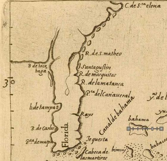
Below, a Spanish made map published in 1601 showing today's St. Johns River as Rio de San Matheo, appearing in author Antonio de Herrera y Tordesillas (died 1625) in his book titled Historia General de los hechos de los Castellanos en las islas I Tierra Firme de Mar Oceano. Map title: Descripcion del Destricto del Audiencia de la Espanola. The river San Matheo flows north from a lake (today's Lake George). Map is found after decade 5, page 6 and is a foldout map. Note: the map errs in showing R. de Mosquitos north of R. de la Matanca (Matanzas), on other, later, maps, Mosquito is south of Matanzas. St. Augustine appears as Santagustin on the map. Cabo de Santa Elena is modern Helena Island near Beaufort, South Carolina.
Below, map circa 1630 by Joannes de Laet, showing the May river descending Georgia's Appalachian Mountains. The Spanish settlement of San Matheo (S. Matheo) and its Barra de San Matheo (the sand bars at the mouth of the San Mateo River) are correctly shown as just north of St. Augustine.
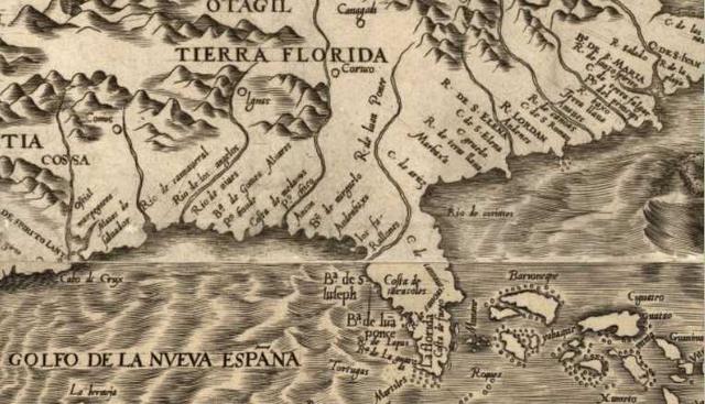
Below, a map of circa 1584 showing the location of the Bay of Juan Ponce (at the Arrow's point) on the southwest coast of Florida, today's Port Charlotte (Frontispice de la Premiere Partie: Indiens d'Amerique, personnifications de la Force et de la Connaissance, putti encadrant des armoiries). Pedro Menendez de Aviles (1565), in error, thought the May River, his Rio de San Mateo, was, at its source,very near the Bay of Juan Ponce, the map's G. (Golfo) de Juan Ponce. This map does not show the San Matheo River of 1565 named in that year by the Spanish conqueror, Pedro Menendez de Aviles.
Below, a 17th century map (1606 Mercator-Hondius) showing the May River (in Blue marker) to be between 31 and 32 Degrees North (pink marker lines). Also shown between 31-32 Degrees North are Cape Francis, and the River of Dolphins, said river understood to be at St. Augustine according to accounts of 1565. St. Augustine, however, is shown at the bottom corner of the map, at just under 30 Degrees North. Pedro Menendez de Aviles (1565) said St. Augustine was at 29 1/2 degrees North and Fort Caroline (Fort San Mateo) was at 30 and a quarter Degrees North. The Spanish San Matheo River does not appear on this map.
Eyewitness accounts regarding Fort Caroline:
Menendez's letter which described the May River as being 30 and one quarter degrees also describes the river's flow and he understands that by sailing upstream he can reach the bay of Juan Ponce, which lies on the southwest coast of Florida. The St. Johns does turn to the southwest, but not to Juan Ponce Bay, rather it is to lakes in the midst of central Florida, but the Spanish had not explored this river yet to realize they were in error. This statement by Menendez, implying that the Bay of Juan Ponce can be reached by sailing upstream to the southwest (Spanish: sudueste) via the May River, or Rio de San Mateo, as he called it, clearly identifies the St. Johns River as being the May River as none of Georgia's rivers flow from the southwest to the Atlantic Ocean.
Menendez:
"...your majesty can send a hundred mariners and their equipment and let them bring everything necessary to found a town in the Bay of Juan Ponce, as this river is part of San Mateo, which we captured from the enemy." (p. 138. Charles E. Bennett. Laudonniere and Fort Caroline, History and Documents. University of Alabama Press. Tuscaloosa and London. 2001. Reprint of 1964, University of Florida Press)
Three errors exist in Menendez's above account: (1) Bennett (1964) has mistranslated Spanish sesenta, meaning sixty as seventy (Spanish: setenta), (2) Bennett has mistranslated Spanish: sudueste meaning "southwest" as "southeast" (Spanish: sudeste), (3) Menendez errs, as the St. Johns does not flow into Juan Ponce Bay (today's Port Charlotte on the southwest coast of Florida), it flows from today's Lake George. New Spain is today's Mexico:
"The River San Mateo, running by the fort we captured, goes seventy leagues inland and turns to the southeast emptying into the bay of Juan Ponce, and from there to New Spain..." Pedro Menendez de Aviles [15 Oct. 1565, St. Augustine] (p. 136., Charles E. Bennet. Laudonniere and Fort Caroline, History and Documents)
Dr. Murray's translation (December 15, 2013) reveals Bennett's errors, sesenta meaning sixty not seventy (setenta) and that the river flows from the southwest (sudueste) not southeast (sudeste). Apparently Bennett (1964), being a non-native speaker of Spanish, confused Spanish sesenta (60) with setenta (70) and este "east" with Spanish ueste "west"? Murray's translation reveals another error by Bennett, Menendez did _not_ say the river flowed from the Bay of Juan Ponce, he said "its end will turn out to be _almost_ at the Bay of Juan Ponce."
"El rio que esta en el fuerte de San Mateo, que tomamos de los franceses, va sesenta leguas para la tierra dentro y no llego al cabo del, la vuelta del sudueste, a salir casi a la Bahia de Juan Ponce."
"The river goes by the fort of San Mateo, which we captured from the French, goes inland, in a southwesterly direction, sixty leagues (about 225 miles) and one still did not reach its end, which will turn out to be almost at the Bay of Juan Ponce." (Dr. Gerald Murray, PhD. Dept. of Anthropology, University of Florida, Gainesville, Florida. The Location of Fort Caroline: Documentary evidence in favor of the St. Johns River hypothesis. An unpublished report dated 15 December 2013. My thanks to Dr. Murray for sharing this info with me. Murray errs in equating 60 leagues with 225 miles, a league was 2.6 miles, so 60 leagues was about 156 miles)
Hawkins learns from the French ships at anchor in the mouth of the May River that their fort is two leagues upstream. A league is the distance a man can walk in an hour, roughly 2.6 miles:
"In this river of May aforesaid, the captain entering with his pinnesse, found a French ship of fourscore ton and two pinnesses of fifteen ton a piece, by her, and speaking with the keepers thereof, they told him of a fort two leagues up, which they had built..." (p. 122, cited from John Sparke, The Voyage made by M. John Hawkins Esquire, 1565, Henry S. Burrage, editor. Original Narratives of Early American History. English and French Voyages, Chiefly from Hakluyt, 1534-1608. Charles Scribner. New York. 1906)
Menendez on the distance from St. Augustine to Fort Caroline:
"Not knowing the way, we hoped to get there in two days, it being distant about eight leagues or so, as we were told by two Indians who went with us as guides. Leaving this Fort St. Augustine...we found the rivers so swollen from the copious rains that it was impossible to ford them and we were obliged to take a circuitous route which had never been used before through swamp and unknown roads to avoid the rivers." (p. 131. Charles E. Bennet. Laudonniere and Fort Caroline, History and Documents. )
Francisco Lopez de Mendoza Grajales' ( a Spanish priest at St. Augustine in 1565) account differs on the distance, it is 5 leagues instead of 8 or 10 leagues:
"According to the practice of those Indians and by the signs they made, we understood that it was five leagues to the fort of the enemies, but on the road it appeared to be more than fifteen.."
(p. 156. Charles E. Bennet. Laudonniere and Fort Caroline, History and Documents. )
"Our fort [St. Augustine] is about fifteen leagues from that of the enemy." (p. 154. Charles E. Bennet. Laudonniere and Fort Caroline, History and Documents)
Fifteen leagues by sea is the distance from Fort Caroline and St. Augustine:
"These, seeing the said six French ships bearing down straight upon them, took to their heels so that they were lost from sight, for they entered a stream fifteen leagues distant from the fort. And the French ships returned to the said harbor of the said fort..." (p.100. Charles E. Bennet. Laudonniere and Fort Caroline, History and Documents)
Another account states it is 8 or 10 leagues by sea from St. Augustine to Fort Caroline:
"Then the Spaniards, apparently thinking that they could not capture our ships...and not wanting to leave the coast, pulled back and went ashore on the Seloy River, which we had named the River of Dolphins. It was some eight or ten leagues from our place." (p. 158. Charles E. Bennett. Three Voyages, Rene Laudonniere. University of Alabama Press. Tuscaloosa and London.2001. Reprint of 1975 University of Florida Presses)
A Frenchman, Stefano de Rojomonte, who was of Fort Caroline in a deposition to Spanish authorities mentions the location of the fort:
"The site of the fort: Questioned as to what parts of the said port the site and fort are established, he said that it may be two leagues from the mouth of the said river, at a high hill, which is above one arm of the said river on the southwest bank." Charles E. Bennet. Laudonniere and Fort Caroline, History and Documents)
Lowery (1905) on early maps, in error, showing the May River and Fort Caroline in Georgia (between lattitudes 31-32 Degrees North):
"Other Identifications: Jean de Laet, in his Histoire du Nouveau Monde, Leyde, 1640...identifies it with the river of St. Augustine.
The Altamaha: Guillaume De l'Isle, in his Carte et Cours du Mississippi...Paris...1718, identifies it with the Riviere des Cavuitas," the Altamaha, as does Io. Bapt. Homann in his map: Amplissima regionis Mississippi seu Provinciae Ludovicianae... (1763).
Mr. George F. Becker, in a carefully prepared note to his "Reconnaissance of the Gold Fields of the Southern Applachians," p. 8 (extract from the Sixteenth Annual Report, U. S. Geological Survey, 1894-95, Part II) argues that the "Riviere de Mai" is the Altamaha, because "Lemoyne's map shows it as the largest river of the South, its main branch extending to the north-west into the Montes Apalatci and placed much further north than one would expect to find the St. Johns. Laudonniere also speaks of the Mai as one of the three great rivers rising in the Appalachian mountains and as being navigable for small boats from the mountains to the sea." Mr. Becker cites the De l'Isle map above referred to in which the mouth of the "Caouitas or May...is shown at a distance north of St. Augustine almost exactly corresponding to the real position of the Altamaha"; he also cites "A new and accurate map of the province of Georgia in North America of 1760 (?) (no. 92, Col. of American Maps made in England. Lib. U. S. Geological Survey), in which the river is labeled, "Formerly river May, now Altamaha or St. George's River."
Mr. Becker's error lies in placing too great confidence in Le Moyne's map, which can be accurate only in respect to the country which the French actually explored, the balance being put in from Indian reports imperfectly understood, if not copied from other and equally unreliable sources. The French at no time went farther up the river than Lake George. They ascended no northerly arm to the mountains, and Laudonniere may well have thought that in a vague Indian account of the Altamaha he recognised a description of a northerly branch of the River May." (pp. 390-391. Woodbury Lowery. The Spanish Settlements Within the Present Limits of the United States, Florida, 1562-1574. G. P. Putnam's Sons. New York and London. 1905)
The reader is advised that modern scholarship understands that almost _all_ of the Latitude readings of the early explorers of America, from the 1500s through mid 1700s are _wrong_ or inaccurate. For the reasons "why" please click on the following title which explains in depth that these explorers were using crude, inaccurate, instruments which were incapable of rendering accurately minutes of latitude: Edmund Farwell Slafter. "History and Causes of Incorrect Latitudes, etc. as Recorded in the Journals of the Early Writers, Navigators, and Explorers Relating to the Atlantic Coast of North America 1535-1740." The New England Historical and Genealogical Register. April 1, 1882.
Slafter sums up his research:
"The result of these investigations leads us to three important conclusions, which we may state as follows:
(1) The early latitudes are generally trustworthy to within a single degree.
(2) The minutes or fractions of degrees, as set down by writers anterior to the middle of the eighteenth century, are never to be relied upon, and are never correct except by accident.
(3) The annotations of the learned comentators upon the latitudes recorded in the journals of our early navigators and explorers, in all cases in which they attempt to identify places, within the limit of one degree, by latitude alone, cannot properly be cited as authority."
(pp. 18-19. Slafter)
Listing of Latitudes found in Early Explorer's journals and accounts (1565) for Fort Caroline and the May River compared to modern degree readings:
Note: Today (2013) this part of the May River (St. Johns River), and St. Johns Bluff (Fort Caroline area) lies in 30 degrees 24 minutes.
May River lies _in_ 30 degrees North Latitude, so, Rene Laudonniere,
placing it on a parallel today with South Ponte Vedra Beach, Florida.
May River lies __in_ 30 degrees plus, so, John Hawkins
placing it on a parallel today with the Guana River State Park, Florida.
May River lies _in_ 30 and a half (30 degrees 30 minutes) degrees, so, John Hawkins,
placing it on a parallel today with Nassau Sound, Florida.
May River lies _in_ 29 and half (29 degrees 30 minutes) degrees, so, Robert Meleneche,
placing it on a parallel with Flagler Beach, Florida.
St. Augustine lies _in_ 29 degrees and a half (29 degrees 30 minutes), so, Pedro Menendez Aviles, placing it on a parallel with Flagler Beach, Florida.
May River (Fort Caroline) lies _in_ 30 and a quarter degrees (30 degrees 15 minutes), so, Pedro Menendez de Aviles, placing it on a parallel today with Ponte Vedra Beach, Florida.
May River lies _in_ 31 degrees, so, Stefano de Rojomonte,
placing it on a parallel today with St. Andrews Sound, south of Brunswick, Georgia.
On 21 Feb. 2014 Drs. Anita Spring and Fletcher Crowe presented a paper arguing that Fort Caroline was not in Florida, but in Georgia. They cited Pedro Menendez de Aviles' 1565 statement in a letter to the king of Spain that he had the reading by the sun done of the fort's location after its capture and the reading was a north latitude of 31 degrees. Spring and Crowe noted that 31 degrees was in Georgia, south of Brunswick and proposed Rhett Island was where Fort Caroline might lay. As noted above, Charles Bennett (1964, Laudonniere and Fort Caroline) had mistranslated the Spanish, de Aviles had said 30 and a quarter degrees, not 31 degrees, placing it nearer to the St. Johns River, than Brunswick, Georgia. If one Googles "Anita Spring, Fletcher Crowe and Fort Caroline" one can find the press release details of their proposals. Apparently they had accepted Bennett's mistranslation? The observant reader will have noted that Woodbury Lowery was aware that in his day, 1905, some had argued that the May River was the Altahamah River of Gerogia, but he had dismissed that proposal.
Why the dismissal? Lowery cited several items, (1) Menendez's statement that Fort Caroline was at 30 and a quarter degrees north which did not put it at the Altahamah River, (2) Menendez said the river the fort was on flowed from the southwest and via it one could arrive in the vicinity of the Bay of Juan Ponce (today's Port Charlotte on the southwest coast of Florida).
I have noted that Le Moyne's 1565 map (published 1591 by DeBry) shows the Bay of Juan Ponce to be very near (just southwest of) the lake (today's Lake George) he has the May River flowing from, this map showing the bay of Juan Ponce (the map's Latin rendering being Sinus Ioan-nis Ponce) to be nearly parallel with Cape Canaveral. I have also noted that Menendez said he renamed Fort Caroline Fuerte San Mateo and the May River was renamed Rio de San Mateo. The 1565 Lemoyne map places Fort Caroline just a tad north of the 30 degrees north parallel and _later_ maps (1600s-1700s) place at this same parallel a settlement called San Mateo, that is to say, San Mateo, like Fort Caroline, are both at the same location, a tad north of the 30 degree parallel. The later maps also show the Rio de San Mateo to be at this same parallel area too, it being listed as Barra de San Mateo (the offshore sand bar entrance to the river) and, as the "River San Matthieu or River St. Jean" (Bellin's map of 1764).
A note of interest: Bennett was not alone in mistranslating Spanish documents, an earlier researcher (1909?) had done the same, misreading Spanish treyenta y un quarto (thirty and a quarter) as treyenta uno (thirty one):
"This Port is 29 1/2 degrees, and the San Mateo which we captured is 31 degrees. The French and their pilots were mistaken. I have had it taken by the sun on land." (p. 23.The Unwritten History of Old St. Augustine copied from the Spanish Archives in Seville, Spain, by Miss A. M. Brooks and Translated by Mrs. Annie Averette. No Publisher or date of publication, but a Library accession stamp says F 20 '09, probably February 20, 1909?). Today (2015) St. Augustine is located at 29 degrees 54 minutes versus Menendez's 29 degrees 30 minutes. The difference being 54 minutes. Add 10 minutes to Menendez's 30 degrees and 15 minutes for Fort Caroline and it is at 30 degrees and 25 minutes and today's Fort George Island, formerly, in Spanish, Isla de San Juan, near the north side of the St. Joihns River (Spanish Boca de San Juan).
Below, "The Parreus Map of French Florida (1562)". See: W. P. Cumming. Davidson College, Davidson, North Carolina. An article in Imago Mundi. Vol. 17. 1963. pp. 27-40. Available for download via the online JSTOR Archive for subscribing institutions:
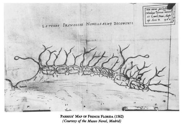
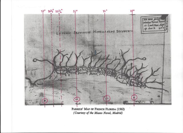
Below, The Parreus Map of French Florida, 1562, upon which I have drawn in red marker, lines of parallel, using the degree markings (in red circles) on the bottom edge of the map: 30, 30 1/4, 30 1/2, and 31 degrees. The 30 1/4 degree parallel matches Pedro Menedez de Aviles' statement that after the fall of fort Caroline he had his men taking its reading by the sun and it was 30 1/4 degrees. At 30 1/2 degrees the first island called May (Amelia Island according to Cumming, 1936) is intersected. To the left of 30 degrees is Cabo Francios, Cape Francis, associated on the 1565 Le Moyne Map with the River of the Dauphin (Dolphins River), where, in 1565 St. Augustine was founded by Pedro Menendez de Aviles. By the way this year, 2015, is the 450th anniversary of the founding of St. Augustine. A special thanks to Dr. Keith Ashley of the University of North Florida (Jacksonville) in directing me to the published research on the Parreus Map.
I must say that I am somewhat disturbed by the 1562 date given this map in its upper corner cartouche. So, what's the problem? The problem for me is that the French account of the discovery of the May River in 1562 says nothing about the French explorers ascending the river to its point of origin in Lake George south of today's town of Palatka. The narrative suggests they were only a few days at the mouth of the May River and had gone no further up it than three leagues, when they saw a "mountain" (today's St. Johns Bluff, 80 feet high) with a nearby field of Indian corn, which they thought would be a good site to build a fort at later. I would think that several days or weeks would be needed to get to Lake George. This suggests for me that the Parreus Map was not drawn up in 1562, it was drawn some time after 1564 and the founding of Fort Caroline, a period when the French would have the time, a whole year (1564-1565), to explore the May and chart its south western origin in today's Lake George. This lake appears in the 29 degree quadrant on the below Parreus map and today Lake George is in the 29 degree quadrant, revealing the amazing accuracy of the map! The 1565 Le Moyne map of French Florida (published 1591 by DeBry) agrees with the Parreus Map in locating this lake in the 29 degree north quadrant too! Cumming (1963, p.28) understands that the Parreus map was "...apparently drawn in 1562 at Charlesfort..." If Cumming is correct, this means that the French left behind at Charlesfort (Port Royal area of South Carolina) in 1562-1563, explored the May River to its southern origin in today's Lake George. This would explain why Fort Caroline doesn't appear on this map, it being built in 1564. Charlesfort's crew left for France in 1563 in a small craft they built. So they had about a year for conducting a series of explorations.
Below, the 1565 Le Moyne Map of French Florida, showing the mouth of the May River to be intersected by the 30 degree Parallel line. Caroline (Fort Caroline) is shown on the south bank of the May River and just above, north of, the 30 degree Parallel line, a matchup with the 30 1/4 degrees parallel on the 1562 Parreus Map, and a match up with Pedro Menendez de Aviles' statement Fort Caroline (renamed by him Fuerte San Mateo) the fort is at 30 1/4 degrees. Lake George is correctly shown in the 29 degree quadrant to be the source of the May River.
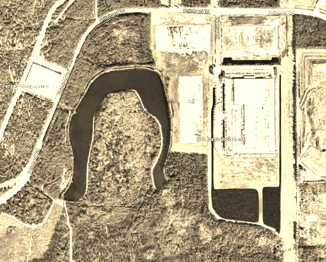
The crescent shaped lake on the above 1565 Le Moyne map might allude to a crescent shaped lake west of Jacksonville (assuming it is not a recently made man-made lake?). It lies near the western terminus of Six Mile Creek, which becomes the Ribault River in Jacksonville before emptying into the Trout River. See the below Google maps of Jacksonville for this lake:
The below 1562 map of Florida by the Spanish cartographer Gutierrez (El Mapa de America de 1562 por Diego Gutierrez) reveals that in this year, 1562, that Spanish cartographers had no knowledge of the origins of the May River as flowing north from Lake George, then turning east ,in the vicinity of today's Jacksonville, to enter the Atlantic Ocean. Apparently, it was the French who charted the May River to its origin in today's Lake George in the 29 degree north quadrant, not the Spanish. The Spanish did know of a river called the Rio de Corrientes, "river of currents" in 30 degrees, and this is assumed to have been renamed by the French as the May River. The only major river traversing Florida, known to the Spanish in this 1562 map is called the Rio de Juan Ponce, flowing from the Appalachian Mountains to the west side of Florida and the Gulf of Mexico (Golfo de la Nueva Espana, "Gulf of New Spain"), said river not to be confused with the Bay of Juan Ponce (Bahia de Juan Ponce, further south of the river's mouth). In 1565, after the fall of Fort Caroline on the May River, to the Spanish Commander, Pedro Menendez de Aviles, he wrote the King of Spain that the river (which he renamed Rio de San Mateo) flowed from the southwest, and via it the Bay of Juan Ponce could be reached (today's Port Charlotte). It is possible that Menendez consulted Spanish maps of Florida before embarking for Florida and that he confused the 1562 Gutierrez map's Rio de Juan Ponce emptying in to the Gulf of New Spain with Bahia de Juan Ponce and assumed that the May River/San Mateo was part of this system?
Fred Cook's (an archaeologist of Brunswick, Georgia) notion (2014) that the Okefinokee Swamp is the great lake that the May river descends from north west to south east on 150 years of maps, was proposed as early as 1913, by Professor Albert H. Wright and Francis Harper in the journal called The Auk. Vol. XXX. Oct. 1913. No. 4 A Quarterly Journal of Ornithology. p. 477. "A Biological Reconnaissance of Okefinokee Swamp: The Birds." Said proposal identifying the St. Marys River as the May River, as quoted:
"A volume might be written concerning the history of the Okefinokee, of which we shall give here only the briefest abstract. From very early times this swamp has been the subject of strange legends and fanciful speculation. As long ago as 1682 it appeared on a map as a Lacus Mag[nus]' at the source of the St. Mary's River (Rio de May..."
Professor Cumming of Davidson, North Carolina (an expert on maps of the south east from earliest times to 1775, notes Professor Lowery (1905) noting dissenters to the May being the St. Johns and Lowery mentions Albert Wright's article of 1945 identifying the May with the St. Mary's and the Okefinokee Swamp being the large lake and waterfall on maps of the 1600s and early 1700s:
"Lowery (pp. 389-93, Appendix B: The Rivere de May") who identifies May with the St. Johns, gives a list of theories advanced by other writers. See also references in Cumming, pp. 68-69. The Parreus map places the May at 30 degrees 15 minutes, which is very close to its actual latitude of 30 degrees 24 minutes...Le Moyne's map places May at 29 degrees 50 minutes, too low, but the Mercator map of 1606, from which most subsequent maps of the seventeenth century derive, puts it at 31 degrees 20 minutes, the latitude of the Altamaha River. This, together with the great lake with the invisible shores in the Appalachian Mountains, led to its identification with the Altahamah, which is the first river north of the Cape of Florida to rise in the Appalachians: cf. Bellin's 1744 map, "La Floride Francoise", and George F. Baker "Reconnaissance of the Gold Fields of the Southern Appalachians", Sixteenth Annual Report, U. S Geological Survey, 1894-5, Part II, p. 8. Albert H. Wright, "French and English Settlements. Rio de Mai." Our Georgia-Florida Frontier: The Okefinokee Swamp, Its History and Cartography (Studies in History, No. 11), Ithaca, New York, 1945, Part III, pp. 1-16, identifies the May with the St. Mary's and argues that the great lake on the River May is the Okefinokke Swamp. He locates Fort Carolina on Reid's or Rose's Bluff on the St. Mary's. Like George F. Becker, Wright disregards the provenance and chronology of the maps and documents he cites; he vitiates his arguments by not differentiating between contemporary eyewitnesses and seventeenth century closet geographers."
(p. 34. W.P. Cumming. "The Parreus Map (1562) of French Florida." Imago Mundi. Vol. 17 (1963). pp. 27-40)
Cumming's study (1938-1962) of the earliest maps reveals errors and when they occurred. He noted that the Le Moynes' Map of 1565, published by DeBry in 1591, shows the mouth of the May River at 29 degrees 50 minutes, it is today at 30 degrees 25 minutes. He noted that in 1606 the Mercator Hondius map moved the lake from south west of the May's mouth (1565 Le Moyne map) to the north west and the Appalachian Mountains to the position of 31 degrees 20 minutes. Thereafter, almost all maps showed the May at Mercator's location. Mercator in 1606 had erased the May's source in the lake (today's Lake George) south west of the May's (St. Johns) mouth on the 1565 LeMoyne map and moved the lake as the May's source from 29 degrees to 31 degrees 20 minutes and the Altamaha River!
So, according to Professor Cumming, for the next 150 years 1606-1750, the May's source at 29 degrees in 1562 (Parreus) and 1565 (LeMoyne) was made to be 31 degrees 20 minutes and the Altahamah River.
The Lake source for the May in 1562 (Parreus Map) and 1565 (Le Moyne) was in the 29 degree quadrant, SW of the river's mouth at 30 degrees 25 minutes today. My study of the early maps 1562 to 1760, reveals that Lake George, source of the St. Johns (May River), appears on Spanish maps of 1575, 1601 and 1683. For the 1683 map which labels it the Rio de San Juan (see Map 94, Plate 40A, "Mapa de la Ysla de la Florida," and commentary on page 176, map no. 94) in William P. Cumming. Revised and Enlarged by Louis De Vorsey, Jr. The Southeast in Early Maps. 3rd edition. 2014. University of North Carolina Press. Chapel Hill and London). The 1575 and 1601 Spanish maps show the river exiting a lake west of Cape Canaveral as the Rio de San Mateo.
An early map sent me by Fred Cook in an email attachment (2015) turned out to be of the May-Altamaha at 31 degrees, not the St. Mary's at 30 degrees 43 minutes.
Professor Cumming on the 1606 Mercator-Hondius Map moving the May's Lake source from 29 degrees to 31 degrees and how his cartographic successors followed his lead for 150 years:
(p.129, Map No. 26. Mercator 1606. William P. Cumming. The Southeast in Early Maps. University of North Carolina Press. Chapel Hill, North Carolina. 2nd edition, 1962 [1st edition was 1958]):
"That part of the territory settled by the French in 1562-1565 depends chiefly upon Le Moyne's map. The gold-bearing mountains of Apaltcy, the lake fed by the great waterfall, the lake with the unseen shore, Lake Sarrope, the French names for the rivers, the location of the French fort at Port Royal; these and many other details are based on Le Moyne. However, there are important changes. The great lake with the opposite shore invisible, which in Le Moyne lies in a southwesterly direction from the mouth of the river May, into which it empties, has been moved northward to the foothills of the Apaltcy Montes. This makes the river May flow in a southeasterly direction instead of the v-shaped course given by Le Moyne...However, the river May is Le Moyne's name for St. Johns River in Florida, on which Fort Caroline was built and which flows in a northerly direction from its sources and lakes in Florida until near its mouth, when it turns eastward toward the sea. By putting the great lake and the direction of the flow of the river May to the northwest of its mouth and changing the accompanying topographical features and Indian settlements, Hondius created geographical misconceptions of the region which lasted for nearly a century and a half. Also he moved the latitude of the mouth of the river May from 29 degrees 30 minutes north latitude (St. Johns is 30 degrees 25 minutes) to 31 degrees 20 minutes. This is actually the latitude of the Altamaha in Georgia, the first river above Florida which has its source in the Appalachian range. These factors undoubtedly encouraged the continuance of erroneous beliefs in the minds of subsequent explorers and cartographers."
In re-reading Le Moyne's account I came across a strange statement made by him that I had somehow overlooked or missed in previous readings. He claims to have shown the King of France maps he made of New France, upon his return from Florida. This suggests, if true, that somewhere in French Archives should be Le Moyne's maps of Fort Caroline and area that would be different from the De Bry examples printed in 1591 because the 1591 engravings do not show the depths of rivers and harbors. Presumably a Department of Hydrology in France would have this data, if it was shown to the King by Le Moyne upon his return from Florida. Le Moyne eventually settled in London, England and his
widow sold his papers to De Bry. So, if the King of France saw these documents, then Le Moyne made a copy which he took to England.
See below:
"...the king...informed me that my special duty, when we should reach the Indies, would be to map the seacoast, and lay down the position of towns, the depth and course of rivers and the harbors; and to represent the dwellings of the natives, and whatever in the province might seem worthy of observation; all of which I performed to the best of my ability, as I showed his majesty, when, after having escaped from the remarkable perfidies and atrocious cruelties of the Spaniards, I returned to France." (p. 2. William Appleton. Narrative of Le Moyne: An Artist who accompanied the French Expedition to Florida under Laudonniere, 1564. Boston. Rand, Avery and Company. 1875, translated from De Bry's Latin Edition)
Below, a map of Florida showing a river running along the east coast, lying on a table next to the hand of Pedro Menendez de Aviles, the conqueror in 1565 of Fort Caroline (the engraving is after a painting of de Aviles about 1575). The river is shown running parallel to Florida's east shore, and extending to the south west of Cape Canaveral (viewer's right). To the southwest of this river (viewer's left) another river appears almost connecting to the coastal river, apparently emptying into the Bahia de Juan Ponce (Bay of Juan Ponce, today's Port Charlotte). This engraving is found in Eugenio Ruidiaz y Caravia, La Florida su Conquista Y Colonization por Pedro Menendez de Aviles. Tomo 1. Madrid. 1893. What is shocking is that this map does not show the May/San Mateo River of the LeMoyne map (1565), it shows the coastal inlets instead, as appear on the below French Map by LeMoyne (1565) published 1591 by De Bry.
Compare the position of the eastern coastal river of the above map with the coastal river on the below map of Le Moyne (1565) published 1591 by De Bry. Quite clearly, the French May River (today's St. Johns River) does NOT appear on the Spanish map by Pedro Menendez de Aviles' hand!
Below, an engraving of Pedro Menendez de Aviles, with a map of Florida on a table near his hand (after an oil painting of circa 1575). Pedro wears on his tunic the cross of Santiago (St. James, an elite Spanish Military Order).