Proposals for the location of Fort Caroline, based on topographical features mentioned in narratives of circa 1562-1570.
Walter R. Mattfeld
Orange Park, Florida 32073
Corrections and comments are welcome at the following
email contact: wrmattfeld411@gmail.com
28 Feb. 2013, Revisions through 31 July 2021
Please click here and also here for additional maps on Fort Caroline and its possible other locations.
A prominent feature appearing in several renderings of Fort Caroline is an "arc-like" shoreline abutting a river.
I suspect this arc-like shoreline, although never specifically mentioned in any narrative, is probably recalling a real and somewhat remarkable topographical feature, today's arc-like shoreline extending from St. Johns Creek to Shipyard Creek, embracing today's (2013) St. Johns Bluff area.
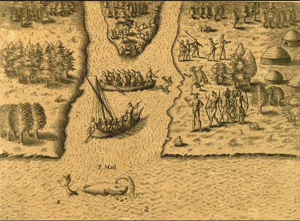
The Le Moyne map of circa 1565 published by DeBry in 1591 shows Fort Caroline to be a triangle type of fort on the south side of the May River (Today's St. Johns River). What is most remarkable is that this map shows the river descending from WNW to ESE, in essence, showing the river to be "east of" the fort, and the fort to be "west of" the river.
I note that one of the engravings of Fort Caroline shows a prominent arcing-shoreline labeled as the Mai F. (Latin for May River or Fluvius). What is strange is that another engraving labels the arc-like shoreline as Occidens, Latin for "west." As the 1591 map by DeBry shows the Fort to be "west" of the May River, perhaps Occidens ("west" in Latin) was intended to mean the fort lay on the west side of the May River, and via some confusion, the engraving showed the arc-like shoreline as to the west of the fort in error? I say this because another engraving labels the stream along the arc-shoreline as "Mai F." (the May River), and this "fits" the arc-like shoreline of St. Johns Bluff from St. Johns Creek on the east to Shipyard Creek on the west. So, via an "error" the fort, laying on the west bank of the St. Johns River was "mislabeled" as facing a river to the west of the fort.
If my proposal is correct, then the arc-like shoreline appearing in the DeBry engravings seems to faithfully preserve today's arc-shoreline at St. Johns Bluff.
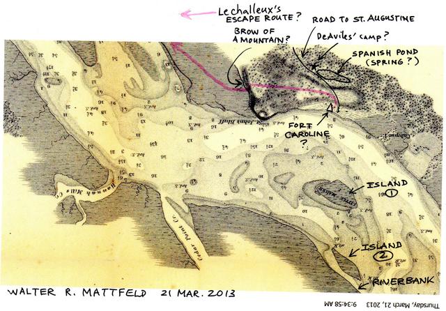
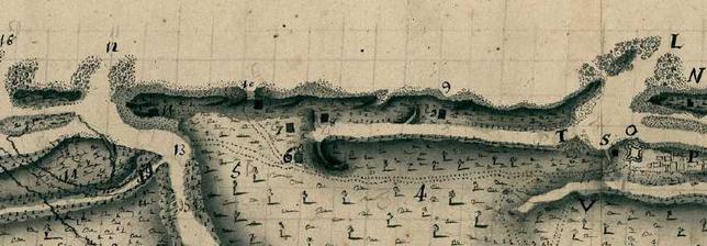
Below, a map of St. Johns Bluff circa 1791 made in St. Augustine, Florida by the Spanish, showing the prominent arcing-shoreline from today's St. Johns Creek on the east to Shipyard Creek on the west. One account mentions the fort's wall being "heightened from the gate to the river on the west." Is there a river west of St. Johns Bluff promontory? Yes, today's Shipyard Creek. If this is the river "west of the gate" then the fort is perhaps east of Shipyard Creek? Some scholars opine that as the fort was built near the river's bank this bank has washed away over some 450 years and the fort isn't recoverable. If this is so, could the "underwater promontory" to the east of Shipyard Creek be where the fort was (shown on the below 1791 map as shallow water)? Alternately, the fort could lie further back from the edge of the river, in which case part of it might still be recoverable? A broad open plain used by the Indians to raise corn is mentioned as the site of the fort, which was "joining a small mountain," The Spanish in 1565 said some Frenchmen fled Fort Caroline to a Monte and its forest, and were later captured on the Monte and slain. Monte is Spanish for "mountain." The below 1791 map legend under the red letter S says "demarcation of the top of the MONTE." There are 3 S's indicating the Monte ridge or top is the whole of St. Johns Bluff, from St. Johns Creek to Shipyard Creek, including Fulton, west of Shipyard Creek. No other place on the below 1791 map is designated as MONTE.
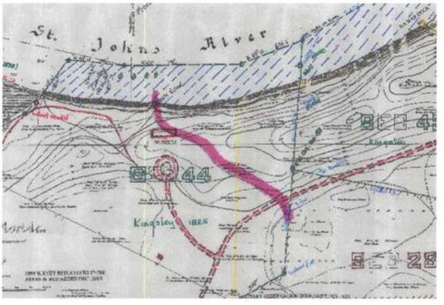
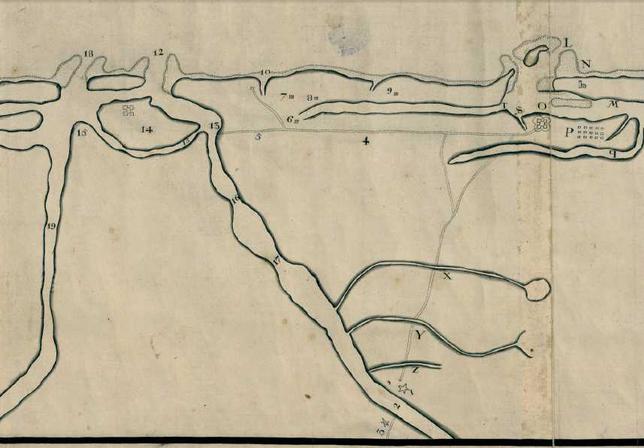
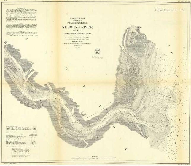
Below, an 1856 Map showing the St. Johns River and its depths. The prominent arcing-shoreline is preserved. I have added in marker, a possible site for Fort Caroline. Little Marsh Island might be the island appearing in the 1591 Debry engraving as opposite Fort Caroline's arcing-shoreline. The French Carpenter, Le Challelux said he leaped a 9 foot high parapet wall (elsewhere described as being the west wall) to escape the Spanish and fled acrosss an open plain, a bowshot in width, to the edge of a wood, where, looking down from this height, he could see inside the fort Frenchmen being slain and their bodies being piled on the river's bank. He then said he proceeded eastward on a path, till he came to "the brow of a mountain" from which he could see the sea and the French ships at the mouth of the river. He descended this steep cliff face by hanging on for dear life to bushes, to descend into the marshes below. I understand this "brow of a mountain" or "rump of a mountain," to be today's St. Johns Bluff Promontory, its steep east-cliff-face being above today's Buck Island. A 1917 topographical map titled Mayport shows this elevation to be 90 feet high as opposed to the small knoll at the river's edge which was 80 feet high in 1917, but is now only 70 feet high on maps since 1950.
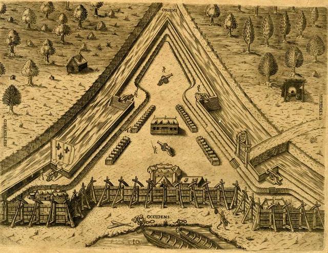
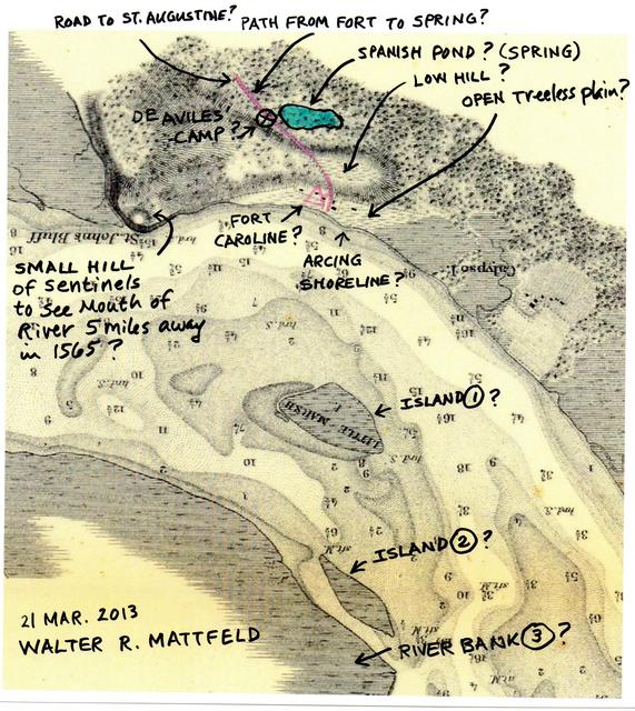
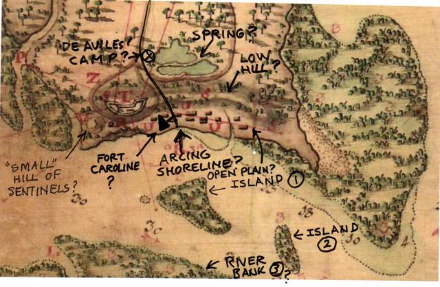
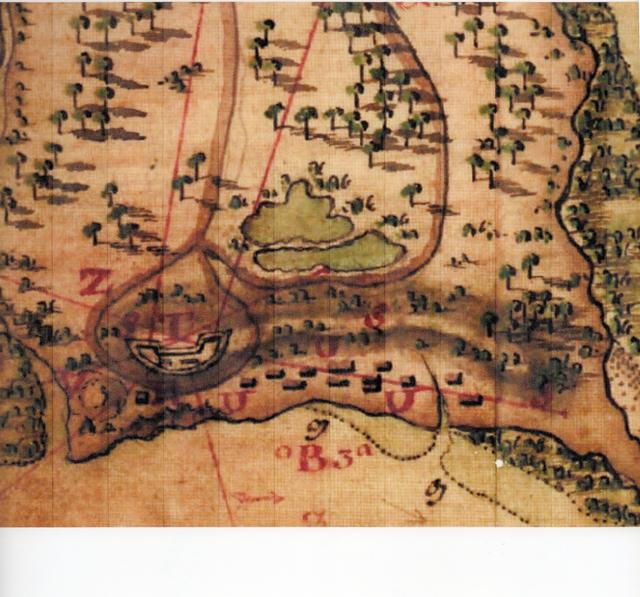
Below, an engraving showing Fort Caroline to be on an arcing-shoreline labeled Occidens (Latin for "west") showing two boats. I understand that this arcing-shoreline is the St. Johns Bluff arcing-shoreline and that the artist, in error, labled this river as west of the fort instead of north (Latin: Septentrio) of the fort. Please scroll above to see this arcing shoreline and its two boats as labeled (correctly) F. Maii (Latin: Fluvium Maii, "River of May"), the French being shown erecting fort Caroline by DeBry in 1591. If I am correct, then the gate in the below engraving should be facing the west (Latin: Occidens). Perhaps the path from the fort to a spring in the woods above the fort is the 1856 map's road to St. Augustine skirting the east side of Spanish Pond (Laudonniere's "spring"?). In which case, the fort's gate, on the west side of the path (?) places the fort east of the 1856 map's road to St. Augustine?
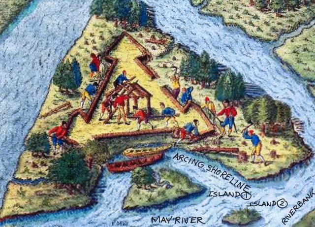
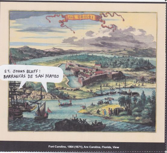
Below, an engraving by DeBry showing the building of Fort Caroline by the French on the banks of the F. Maii (Latin: Fluvium Maii, "River May") on what appears to be an island surrounded by water on three sides. Note that the May River is shown as having created a prominent arcing-shoreline opposite the fort (the Latin word F. Maii appears in small print just to the viewer's left of the two islands). I understand this arcing-shoreline is today's arcing-shoreline from St. Johns Creek to Shipyard Creek. The nearest island below the two boats might be Little Marsh Island appearing on the 1856 Survey map of the St. Johns River. The streams to the east and west of the fort, emptying into the May River might be St. Johns Creek on the east and Shipyard Creek on the west. Alternately, the two streams could be a continuation of the St. Johns River, the eastern stream (viewer's left) being Chicopet Bay, the western stream (viewer's right) being Mill Cove Bay? This engraving clearly labels the May River and its peculiar arching-shoreline to be today's St. Johns River and its St.Johns Bluff arcing-shoreline. Another engraving, scroll down below, in error (?) labeled the fort's west side as facing an arcing-shoreline. It was the fort's north side that faced the May River(St. Johns River) as shown in the below drawing.
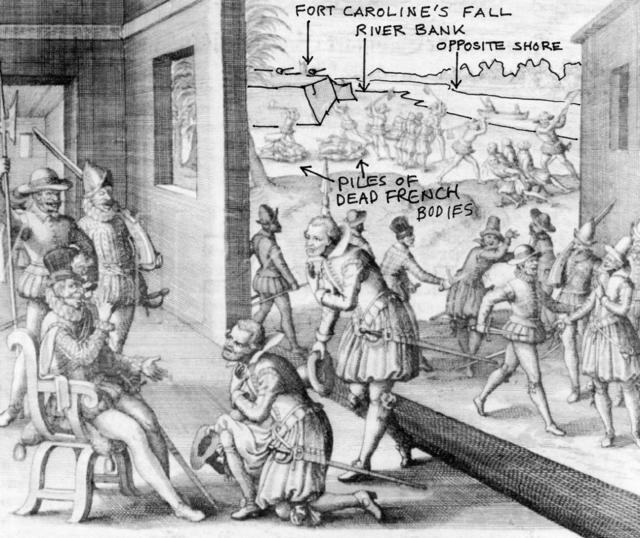
Below, an engraving showing the fall of Fort Caroline to the Spanish in 1565. In the background the fort is shown on the south bank of the river May (Spanish renamed Rio de San Mateo), with two piles of dead French bodies. In the river is a boat with two men. On the oppostite shore, trees. The fort's wall is shown to be on the river bank. In the foreground a small hill (in shadow) with a tree, is perhaps an allusion to the small hill (today's Parking lot atop a small hill/knoll at the Ribault Pillar Monument?) French sentries climbed this knoll or pequena alta to get a view of their ships at the mouth of the May River? The King of Spain, Philip II, in his palace, in Spain, is apparently being told by his men of the fall of the Fort to the Spanish. Engraving circa 1591 by DeBry. Note the arcing-shoreline in front of the fort, perhaps this is today's arcing-shoreline associated with St. Johns Bluff?
Below, a Google Earth Sattelite view showing the arcing-shoreline of St. Johns Bluff. St. Johns Creek (a marshy area) is east of St. Johns Bluff, Shipyard Creek (another marshy area) is west of the bluff. Note the two ponds on the south side of St. Johns Bluff appearing as dark spots. The bigger pond is on the viewer's left, the smaller pond the viewer's right. Both ponds lie with a deforested semi-circular basin, which floods and becomes a marsh with heavy rains. The 1565 French and Spanish accounts speak of a marsh or spring on the other side of the mountain (Spanish: Monte), reached by two paths from the fort at the river's shore.
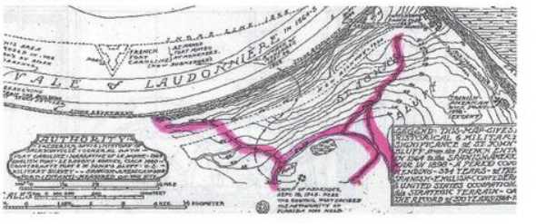
Below, the 1791 map of the St. Johns River, in Spanish, drawn up at St. Augustine. Note the two islands opposite the arcing-shoreline of St. Johns Bluff, which may be DeBry's two islands in his engraving showing Fort Caroline being built on a arcing-shoreline of the May River. DeBry's two rivers on his engraving of the erection of Fort Caroline (see above) might be an allusion to St. Johns Creek, east of St. Johns Bluff, and Shipyard Creek west of the Bluff? The map key, three red S letters, shows that today's (2013) hill ridge extending from St. Johns Bluff on the east to Fulton Point on the west is labeled as Monte, Spanish for "Mountain or Mount." The Frenchman Le Challeux (a carpenter) who escaped the Spanish massacre stated that a mountain existed near the fort from which he could see French ships at the mouth of the May River. The red letter V on the below map says this is "a small height," pequena altura, from which one can see all the way to the Barra," (the mouth of the river) supporting Le Challeux's 1565 account. Could the below two high-land promontories of St. Johns Bluff, flanked by marshes, be the Barrancas de San Matheo, "Bluffs of San Matheo" appearing on the Antonio de Arredondo map of 1737 (scroll down to see this map)?
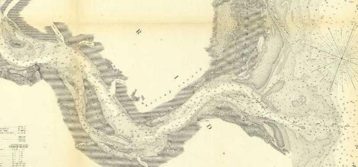
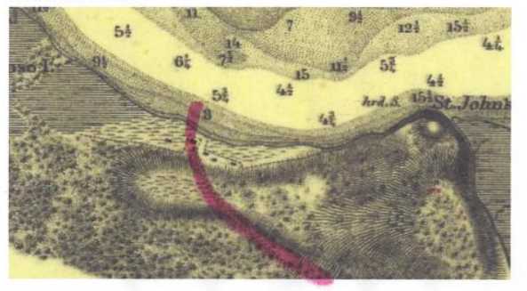
Below, the 1856 survey of the St. Johns River showing two islands opposite St. Johns Bluff which appear to be in about the same position as the two islands appearing in the above engraving by DeBry (1591) of Fort Caroline being erected on a arcing-river-shoreline. Perhaps these two islands are DeBry's two islands? Island No.1 seems to have a small river on its south side in the DeBry engraving and I note that Island No. 1 on the 1856 map also has a small river on its south side. If islands No. 1 and 2 of the 1856 map are preserved in the 1591 DeBry map then Fort Caroline should be on the arcing shoreline of the St. Johns River opposite these islands. St. Johns Bluff (70 ft. high) appears in the narratives under conflicting descriptions: as a hill of some height and as a small mountain or mountain. Atop the bluff is a knoll, today's Ribault Pillar Monument parking lot (2013), from which, the 1791 map said the Bar at the mouth of the river could be seen. The French account says from this small hill sentinels could see French ships outside the Bar, in the Road, at the mouth of the river in 1565, two leagues away (5 miles). Update of 12 Feb. 2014: In a deposition to Spanish authorities a Frenchman said Fort Caroline was "at a high bluff (Spanish: barranca alta) by the southwest arm of the river, two leagues from the river's mouth." Perhaps the high bluff is St. Johns Bluff promontory (70 feet today, earlier 80 feet) and the southwest arm of the river is the river channel south of Great Marsh Island on the 1856 map?
How to find Fort Caroline:
The fort is beleived to have been burned to the ground in 1568 by the French in reprisal for the slaughter of its French defenders by Pedro Menendez de Aviles in 1565.
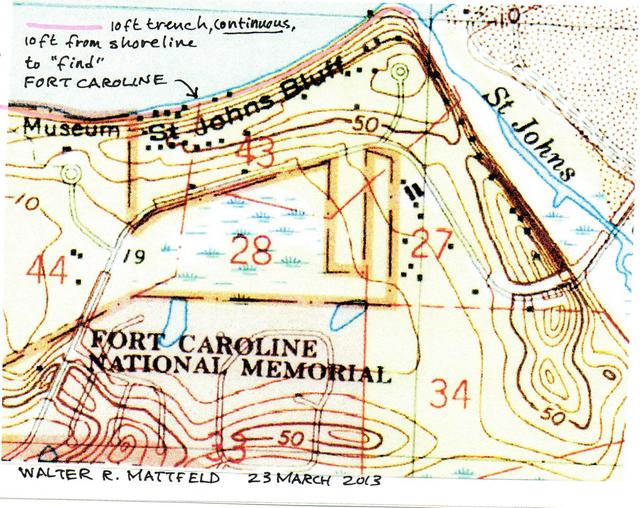
Assuming that a line of charcoal may remain of the burned walls, It is my proposal that a continuous trench 10 feet deep, and 10 feet wide be dug within 10 feet of the present shoreline (said fort being built on the river's bank according to witnesses of 1565), from St. Johns Bluff Promontory to Fulton Point.
A continuous trench is to be favored over a hit and miss test trench with open areas, as the open areas may hide the very wall outline being searched for.
When Dame Kathleen Kenyon sought Jerusalem's ancient wall, she dug a continuous trench from the top of the hill to the bottom of the valley below. She found not only what she was seeking, the ancient wall, she found a second wall, paralleling the older wall (an expansion of the city in antiquity).
Kenyon's methodology, in my opinion, should be applied here to find the charcoal outline of the fort, if such exists (hoping such an outline has not been destroyed by later build-overs during the past 450 years, or that the shore it sat upon has not been washed away).
Fort Caroline's degree readings according to witnesses in 1565
(1) Pedro Menendez de Aviles after the fall of Fort Caroline to his troops in September of 1565 had its position identified by a sextant reading, claiming it lay in 30 and a quarter degrees North Latitude: "...en treynta y un quarto..." (p. 390. "Appendix B. The Riviere Mai." Woodbury Lowery. The Spanish Settlements Within the Present Limits of the United States, Florida, 1562-1574. G. P. Putnam's Sons. New York. 1905)
(2) Sir John Hawkins, an English Privateer, visited the fort in August of 1565 (Lowery, in error, says May of 1564) and he said the "...Frenchmen abode at 30 and a half degrees..." (see p. 389, "The Riviere Mai," Appendix B. Woodbury Lowery. The Spanish Settlements Within the Present Limits of the United States, Florida, 1562-1574. G. P. Putnam's Sons. New York. 1905): "Hawkins, who visited Laudonniere's settlement on the river May in 1564, found the river standing in 30 degrees and better.." My note: Hawkins gave _two_ readings: 30 degrees and better, then later 30 and a half degrees.
Today one degree is 60 minutes, half a degree is 30 minutes, a quarter degree is 15 minutes. Thus:
Aviles' 30 and a quarter equals 30 degrees and 15 minutes.
Hawkins' 30 and a half equals 30 degrees and 30 minutes.
Today's National Park Service Museum for Fort Caroline is at 30 degrees 22 minutes, computed from its Fort Caroline Road address, but the south shore of the St. Johns River lies in 30 degrees 23 minutes and this is where Fort Caroline should be.
The problems?
Aviles' reading of 30 degrees 15 minutes locates Fort Caroline south of the Museum, on a parallel with Ponte Vedra Beach
Hawkins' 30 degrees 30 minutes locates the fort north of the Museum, and far beyond the St. Johns River, on a parallel with Nassau Sound.
Some scholars, however, have determined that these readings, of 1565, are inaccurate by modern standards, as noted in Fraser's 28 page monograph (see Walter B. Fraser. The First Landing Place of Juan Ponce de Leon on the North American Continent in the Year 1513. Privately printed by Walter B. Fraser. St. Augustine, Florida. 1956. Cf. especially pp. 1-6). I got my copy at the Fountain of Youth souvineer store in Saint Augustine.
According to Fraser, the Spanish reading for Juan Ponce de Leon's siting of Florida on 02 April 1513 at 30 degrees 8 minutes is off by -9 minutes:
"For a correct determination of a latitude, by observation of the Sun, as practiced in Ponce de Leon's time, it was neccessary not only to measure the angle of the Sun's height, but also to have a table giving the Sun's declination (its angular distance north or south of the Equator), for that particular day. The Regiomontanus Table, in use at that time, was not correct. The error in this table, for April 2, 1513, has been calculated. By correction of this error, the actual position of Ponce de Leon's ships is shown to be at latitude 29 degrees 59 minutes. This is five nautical miles north of St. Augustine Inlet. The Inlet, and St. Augustine Harbor would be in plain sight of a look-out in the "crow's nest" of Ponce de Leon's ship." (p. 2. Fraser. 1956)
Fraser, citing William J. Peters' research of March 6, 1939:
"The error in declination is 9' and as Regiomontanus' value is larger than Newcomb's, the latitude deduced, namely 30 degrees 08 minutes, is too large by this amount due to errors in the ephemeris only."
So, Fraser understands that de Leon's 30 degrees 08 minutes is actually -9 minutes off, its 29 degrees 59 minutes and five nautical miles north of St. Augustine's harbor (p. 2. Fraser).
Assuming de Aviles' readings are also -9 minutes off as well, his 30 and a quarter degrees or 30 degrees 15 minutes becomes 30 degrees 06 minutes? This is unacceptable as it locates Fort Caroline on a Parallel with the Guana River State Park on the Atlantic Coast, south of Ponte Vedra. If, however the error is +9 minutes then Fort Caroline lay at 30 degrees 24 minutes, the vicinity of St. Johns Bluff and the St. Johns River today (2015).
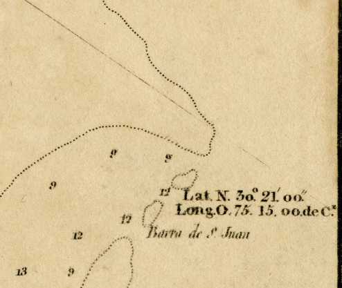
Hawkins' 30 and half (30 degrees 30 minutes) becomes 30 degrees 21 minutes if a -9 minute error of declination is factored in. I note that the 1809 map of the San Juan Rio made in Madrid, Spain, shows the Barra de San Juan as lying in 30 degrees 21 minutes which is a match to Hawkins' adjusted reading of 30 degrees 21 minutes. In other words, Hawkins 'reading may have been done at the Bar or Spanish Barra, the sandbar entrance to the St. Johns River as the narratives state his ships were of too deep a draft to sail into the shallow waters of the St. Johns (French: May) River.
Stefano de Rojomonte, a captured French mutineer from Fort Caroline, told the Spanish authorities at Havana, Cuba that Fort Caroline was at 31 degrees. Today, 31 degrees is the area of St. Andrews Sound south of Brunswick, Georgia. Perhaps Rojomonte was lying to save his comrades from being killed by the Spanish? (see p. 390. "Appendix B. The Riviere Mai" Woodbury Lowery. The Spanish Settlements Withinin the Present Limits of the United States, Florida, 1562-1574...G. P. Putnam's Sons. New York. 1905): "La ribera de Mayo que esta segun dizen en treynta y un grados de altura."
Peters noted that errors in declination were _not_ constant, they could change depending on the season of the year, taking on positive (+) and negative (-) readings:
"If any consideration is to be given these latitude-errors, the declination should also be computed by the Alphonso tables. The two editions of Regiomontanus covering overlapping periods give identical results. They also give the dominical letter and church days. It should be noted that the error produced in the declination by the error of the ephemeria is not constant and may be positive or negative depending upon the time of year." (p. 6. Fraser. citing William J. Peters' research in a letter of 6 March 1939, of the Department of Terrestrial Magnetism, The Carnegie Institution of Washington, D. C.)
By adding 9 minutes as a POSITIVE error rather than subtracting 9 minutes as a negative error, the degree reading of de Aviles in 1565, 30 degrees 15 minutes, corrected to 30 degrees 24 minutes, locates the fort within this Parallel where is today the National Parks Service's Museum for the Timucuan Preserve (also called St. Johns Bluff and the reconstructed model of the 1564-1565 fort (see Florida Atlas and Gazetteer. Delorme Publishers. Freeport, Maine. Fourth Edition, 1997. Map no. 58 Grid A).
The surprise for me in all this, is the realization that De Aviles' men were so correct in fixing the location of Fort Caroline en treynta y un quarto, "in 30 and a quarter" when allowing for a +9 degrees error noted by Peters in 1939 aligns with the Delorme map of 1997, while Hawkins' reading of 30 and a half, or 30 degrees 30 minutes, when adjusted by -9 minutes to 30 degrees 21 minutes, is a spot-on-match to the 1809 Spanish map showing the San Juan River and its Barra de San Juan to be 30 degrees 21 minutes (see the below map titled Boca y Barra del Rio San Juan. Madrid, Spain. Department of Hydrography. 1809)
I have often wondered "why" scholars who have done research on Fort Caroline never saw fit to establish its location via the degree readings of Rojomonte, de Aviles and Hawkins back in 1565. Now I know "why," the readings of Rojomonte and De Aviles were not accurate and too vague to be of any use by today's standards. Hawkins' reading would fall in this same category at 30 degrees 30 minutes, but when a -9 minute declination error is factored in, Hawkins is _spot-on_ for the mouth of the St. Johns River at its Bar entrance (see the below 1809 map)!
For a detailed scholarly account of why the latitude readings which appear in the accounts of America's early explorers are generally not to be taken as accurate (the instruments being used until 1740 were too crude to render minutes of latitude accurately) please click on the following title which covers the subject in depth: Edmund Farwell Slafter. "History and Causes of Incorrect Latitudes, etc. as Recorded in the Journals of the Early Writers, Navigators, and Explorers Relating to the Atlantic Coast of North America 1535-1740" The New England Historical and Genealogical Register. April 1, 1882.
Below, my proposals for the location of Fort Caroline (Spanish: Fuerte de San Mateo) drawn over a satellite map of the St. Johns Bluff area ( 03 August 2014).
Menendez had with him a Frenchman who had lived at Fort Caroline. The indians had lead the 500 Spaniards from St. Augustine to a marsh where they waited the night in knee deep water waiting in a pouring rain for daylight with 20 scaling ladders to breach the forts's walls. The Frenchman recognized the topography of the area with daybreak and told the Spanish beyond a hill lay the fort, about 3 bowshots away, near the river. Menendez also said that the Frenchman had informed him that an open plain existed between the fort and the edge of a forest about 1/4 of a league in width they could reassmble at if their attack on the fort was repulsed. Le Challeux's account (a Frenchman in the fort who escaped the Spanish slaughter) said an open plain existed one bowshot in length from the fort to a forested slope above the fort. From this wood he could see Frenchmen being slaughtered by the Spanish and their bodies piled up at at the river's shore. As the fort's walls were 9 ft. high the slope he saw this from had to be higher than 9 feet. Modern topographical maps reveal the hill ridge opposite Spanish Pond is from 50 to 40 feet in height, high enough to see within the fort's 9 feet high walls and the river bank.
The dimensions of Fort Caroline are not given but in 1576 shipwrecked Frenchmen at Port Royal, South Carolina, under Strozzi, built a triangular fort of 66 paces on each side or 130 feet per wall.
Today's Spanish Pond, I understand was the "spring" of fresh water mentioned in French accounts. The St. Johns River is a tidal river and its water is brackish, from the Atlantic Ocean's salt water, all the way to Lake George, south of Palatka. It was necessary for the French to have drinking water and the spring at Spanish Pond was probably that source. In times of heavy rains the spring apparently expanded covering a much larger area making the area a marsh, as noted in the French and Spanish accounts. Later, the French and Spanish could have dug cisterns to catch rain for drinking water or used wooden barrels to the same purpose instead of having to daily trudge uphill to the spring at Spanish Pond. The 1898 map shows two ponds existing side by side at Spanish Pond and so too do modern satellite images (2015). A third source of water is Shipyard Creek, that seems to be spring fed, as its origin appears to be the slope above Calypso Island.
A year-long settlement, 1564-1565, would be impossible without access to fresh water. While structures made by man might come and go over 450 years (1564-2014), one would expect that the spring of fresh water would remain and perhaps the path leading from the fort to it? That being the case, perhaps by identifying first the spring of fresh water and then a road to it heading for the river's bank, we can locate the Fort on this route?
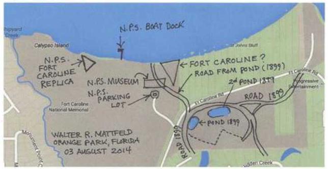
A map created in 1899 shows a pond of freshwater and a road leading off from it to the bank of the St. Johns River. Perhaps this road preserves the footpath the French used to access the spring? If so, then the 1899 map reveals Fort Caroline is on National Park Service property (colored light brown) and is located just ENE of the N.P.S. Museum building (behind the museum, at the river bank).
I have drawn up a map using details from the 1899 map superimposing them upon a 2014 Goggle Sattelite map of the area. My thanks to Cleve Powell of Jacksonville for providing me with a copy of this very important map. Its importance for me being that it shows a road from the pond, crossing over a low hill, and descending to the river's edge, rather as described in the French accounts.
The 1899 map shows two ponds. The first is to the viewer's left and a road leaves this pond heading directly for the river bank where it ends. The map states the ruins of a building exist at the river's bank. Was this building used to bring freshwater to ships docking here for replenishing their water supplies?
A trench needs to be dug in this area, ideally about 10 feet from the river's edge, from just behind the museum all the way to the east border of the NPS property line to see if any archaeological remains exist. A bulldozer or back-hoe used in laying pipe could remove the topsoil at a depth of one foot, then archaeologists would dig down to a depth of about 4 to 5 feet for the fort and its buildings' foundations. Laudonniere did state that he sent his men out daily in a boat to collect riverbank clay a few leagues away suitable for making bricks from to build houses of. Perhaps these bricks were used in building foundations, if so, they ought to still exist. He also mentioned an oven to bake bread in and presumably to cook meals as well which would require clay-fired bricks. He did not build fireplaces in the homes fearing the palmetto leaf roofs might catch fire.
Below, my proposal for the site of Fort Caroline based on the 1856 and 1899 maps' road crossing the western hill ridge and terminating in the open plain of the 1791 and 1856 maps.
Professor Miles Harvey noted that Professors Robert Thunen and Keith Ashley of the University of North Florida, Jacksonville, are of the opinion that the most likely location for Fort Caroline is the area shown on the above map, but permissions from home owners would be needed to explore their yards for the remains of the fort. As some of these homes are valued from one to two million dollars, each, it seems dubious that such permissions would be granted, not wanting their manicured yards dug up. If permissions are denied, the next best resort, I would suggest, would be to have this shoreline area declared State property under Right of Eminent Domain, to protect and preserve the fort's locale as a National Historical Treasure, placing it under the protection and administration of the National Park Service which is located nearby.
Miles Harvey (2008):
"After I left Florida Thunen and his team would search for the fort at two nearby locales, again, in vain. Then the hunt would stall, in part because the most promising places to dig were on private property and getting access to those sites, many of them in upscale subdivisions, would require them to overcome considerable logistical and legal obstacles..." (p. 252. Miles Harvey. Painter in a Savage Land. The Strange Saga of the First European Artist in North America. Random House. 2008)
On 10 July 2013 I received an e-mail from Dr. Keith Ashley, an Anthropologist at the University of North Florida (Jacksonville) advising me that he was successful in getting permissions from some property owners and that an exploration had been done recently of the following areas: (1) The Ribault Pillar Monument area; (2) St. Johns Creek; (3) the shore of the St. Johns River west of the Monument; (4) the Shipbuilder Creek area. In none of these areas were artifacts found of the 16th century of the French and Spanish, nor the Indians. Based on this finding Dr. Ashley has expressed doubts that Fort Caroline is in this area. He noted that even if the fort had eroded away there should be some artifacts, but none were found of this era. He did note that artifacts were found of the Civil War (1861-1865) and of the British occupation of Florida (1763-1783).
The excavations done were of 3 foot by 3 foot squares, 3 feet deep. I have watched the BBC British program called _Time Team_ and believe their system would be much more productive. They first gather journals, old blueprints and drawings and study them for the site they wish to "archaeologically verify." They then get a small backhoe (or small bulldozer) and have its operator remove the topsoil to the depth of about one foot. Then they set their trained diggers to digging out the rest of the area, a trench of about 80 feet by 20 feet and four to five feet deep, looking for building remains such as foundations and possibly walls. Metal detectors also scan periodically the diggings looking for any metal objects. The work crew seems to be small, not more than a dozen or two dozen people, usually students or volunteers, with an on duty archaeologist overseeing the finds. They sometimes have only 3 days to do this work in, surely Fort Caroline can be dug up in three days, via a trench 4 feet deep, if it is near the road going from the riverbank to the freshwater pond?. An alternate location for the fort is further east, at the crest of a hill, a path is shown ascending the hill's top from the river, then descending to the easternmost pond.
Dr. Keith Ashley of the University of North Florida, Jacksonville has informed me that test probes (3 ft. by 3 ft.) were made in the area behind the National Park Service Museum and nothing was found of the 16th century, French or Spanish.
In 1565 Pedro Menendez de Aviles after capturing French Fort Caroline, renamed it Fuerte San Matheo in honor of St. Matthew's day upon which it had fallen. He ordered his men to take the site's location from a siting of the sun and they reported it was located at 30 and a 1/4 degrees (Spanish: "tryenta y un quarto"), which translates today to 30 degrees 15 minutes, on a parallel today (2015) with Ponte Vedra Beach, 12 miles south of today's St. Johns River and Mayport Naval Station. The instruments available in 1565 were very crude not capable of determining minutes of latitude very precisely. Nevertheless the French had made two maps of the May River, one in 1562/3, the other in 1565. Both clearly show today's St. Johns River to be the May River. Spanish made maps of Florida after 1565 should be expected to show this river (the French May) to be labeled the Rio de San Matheo, and such is the case. For example, below is a map made in 1601 showing today's St. Johns River as R. de S. Matheo and it clearly flows from the south west, then turns east to empty into the Atlantic Ocean. The below map shows the river emerging from a lake to its south, apparently today's Lake George, said lake also appears on the two aforementioned French maps or 1562/3 (Parreus Map) and 1565 (Lemoyne Map, published in 1591 by DeBry). The below 1601 Spanish map has degree markings on both its east and west sides and the mouth of the R. de S. Matheo lies in the 30 degrees quadrant, the same quadrant that today's St. Johns River lies in. The map is is attributed to Antonio de Herrera y Tordesillas who died in 1625 in Spain. This map is part of the Ansbacher Map Collection located at the Jacksonville, Florida Main Library, Fourth Floor, North Wall #1, No. 242. This map is important for showing that Spanish Cartographers were still calling today's St. Johns River the San Matheo, some 60 years after receiving its name from Pedro Menendez de Aviles in 1565, upon the fall of French Fort Caroline to his troops. He said this the Rio de San Matheo flowed from the south west and was approximately 60 leagues (150 miles) in length and by sailing its length one would arrive near Bahia de Juan Ponce (today's Port Charlotte on the west coast of Florida).
Below, the May River as Latin F. Maii ("Fluvium May"), shown with a very large island in its midst, dividing the river into two arms or streams. Could this unusual landform be today's Great Marsh Island? A captured French mutineer at Havana, Cuba deposed before Spanish authorities that Fort Caroline was located near a high bluff (Spanish: barranca alta) above the southwest arm of the river. St. Johns Bluff lies to the northwest of the St. Johns River's lower arm, just northwest of Great Marsh Island. The 1809 map labels St. Johns Bluff as Barrancas de San Mateo (Bluffs of San Mateo), and Fort Caroline's name was changed to San Mateo in 1565 by the Spanish. The 1737 map by Arredondo labels a road extending north from St. Augustine to the San Juan River ending at No. 13, Barrancas de San Mateo. The road (No. 5) is called Camino para de Barancas de San Mateo (scroll to bottom of this page for the 1737 map)
Below, Great Marsh Island on the 1856 map, perhaps DeBry's island (1591 publication) in the above engraving? Great Marsh Island in 1856 did split the river into two arms, a north-eastern arm and a south-western arm.
Below, the 1899 map (U. S. Army Corps of Engineers St. Johns Bluff showing Spanish American War 1898-1899 Gun emplacements) shows a road from a pond to the bank of the St. Johns River. Superimposed on this map is the location of the NPS Museum and replica of Fort Caroline at the edge of marsh to the viewer's left. Rock rubble has been laid down by the Corps of Engineers to prevent erosion of the river bank due to the building a jetties in the river. I have marked in red marker the road from the pond to the river's edge in 1899. The contour lines on this map reveal that the least sloping area of the bluff is the area along the road from the Pond. The slope to the east appears to be steeper and less conducive to erecting a fort and out buildings. In other words, the area where the NPS museum is at, is the best site for Fort Caroline, but at the river's edge as noted by the French and Spanish accounts. My thanks to Cleve Powell of Jacksonville for sharing this map with me. He understands Fort Caroline is near Shipyard Creek.
Below , a historical map (after 1933) showing the proposed site, underwater, of Fort Caroline (assuming a washed away shoreline). I have added in marker the road system before 1934. Again, my thanks to Cleve Powell of Jacksonville for this map.
Below, the 1856 Map showing the road crossing over the hill ridge from the riverbank and a settlement of six houses. This 1856 road appears to be the same road appearing in the later 1899 map.
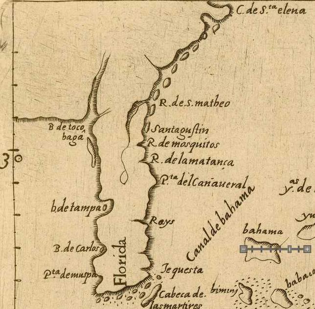
Below, a closeup of the above 1601 map showing the Rio de San Matheo to be in the same location and configuration as today's (2015) St. Johns River. Scholars claim this 1601 map is a later copy of an earlier Spanish map made in 1575. Note: The Spanish cartographer has located St. Augustine (Spanish: Santagustin) and the Matanzas River inlet (Spanish: R. de mosquitos), south of the city, WRONGLY in the 30 degrees quadrant! Today (2015) the city of St. Augustine is situated at 29 degrees and 58 minutes. The mouth of the St.Johns River (Spanish: R. de S. matheo) is at 30 degrees 21 minutes. In other words the below map's 30 degree line should be just north of Sanagustin (St. Augustine) and south of the mouth of the R. de S. matheo.
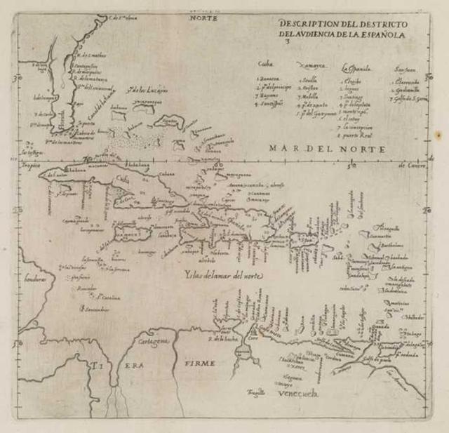
Below, closeups of the 1575 map showing the Rio de San Matheo to be in the same configuration as today's St. Johns River. Cartographer: Juan Lopez de Velasco. Map title: Descripcion de la Audiencia de la Espanola. Book title: Demarcacion y diuision de las Yndias. The Rio de San Matheo exists a lake to the southwest, opposite Rio de la Matancas (Matanzas inlet is south of St. Augustine, Augustine is not on this map). It flows north, to the west of Matanzas and Rio de Mosquitos. Note: the Inlet of Mosquitos on later maps is south of the Matanzas inlet. This is the earliest Spanish map showing the St. Johns to be the Rio de San Matheo based on its general position vis-à-vis Mosquitos, Matanzas, and Lake George to the west of Matanzas. This map was drawn up just 10 years after Fort Caroline fell to Pedro Menendez de Aviles in 1565, who renamed the May River, Rio de San Matheo.
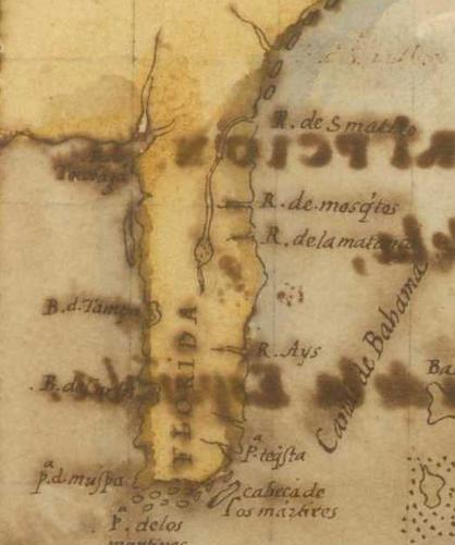
Below an expanded version of the above 1575 map by Velasco. This map was made just 10 years after the French May River had been renamed Rio de San Matheo by Pedro Menendez de Aviles, the founder of St. Augustine in 1565. I find it strange that St. Augustine does not appear on this map and that R. de mosquitos is wrongly located north of the Rio de la matancas.
Below, a map dated 1757 showing the Spanish Rio de San Matheo (English: River of St. Mattheo or St. Matthew) to be also called the Spanish Rio de San Juan (English: St. John's River). Cartographer: John Mitchell. Map title: A Map of the British and French Dominions in North America. 1757. Available at the U. S. Library of Congress. Notice that this river emerges from a lake west of Cape Canaveral and flows north and west of Mosquitos inlet, Matanzas Inlet, and St. Augustine, then turns east to the Atlantic Ocean like the 1575 and 1601 Spanish maps' portrayal of the Rio de San Matheo (the French May River of 1562-1565)
Below, an anonymous cartographer's 1683 Spanish made map of Florida showing the Rio de San Juan emerging from lakes opposite Cape Canaveral. It is titled: Mapa de la Ysla de la Florida. Plate 40A, Map 94, p. 176 in William P. Cumming, enlarged by Louis De Vorsey Jr. 3rd edition. 1998. Chapel Hill & London. The Southeast in Early Maps. Some scholars suggest the cartographer was Alonso Solana the younger, an Adjudant stationed at St. Augustine.
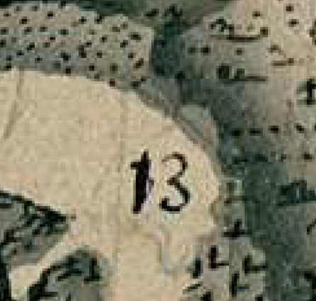
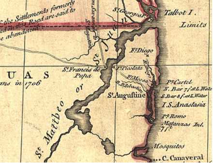
Below, a Spanish map, circa 1737, showing a road extending north from St. Augustine and ending at Barrancas de San Matheo (No. 13). The road is labeled Camino para Barrancas de San Mateo under map key Number 5 (it passes south of number 6 and north of number 5. It ends at number 13 which is labeled in the map legend or key as Barrancas de San Matheo donde hubo poblacion ("Bluffs of San Matheo where was a population)." "Where was a population" suggests Barrancas de San Matheo was an abandoned settlement by circa 1737. St. Augustine and its fortress appears at alphabetical letters S and O, the town being south of the fortress. Another fortress appears at No. 14, on an island north of Barrancas de San Matheo and is described as an "English Fortification on the island of San Juan." The map was made in 1737 by Antonio de Arredondo of Havana, Cuba. He visited the small military outpost at San Matheo and described it as being in poor repair in his report to Spanish authorities. Barrancas in Spanish means "bluffs" in English. The second road leaving St. Augustine takes one due west to the fortlet of San Francisco de Pupa on the San Juan River. This road begins just north of alphabetical letter V.
Below, a close-up of the above 1737 map showing the Camino para Barrancas de San Matheo (shown as two dotted lines opposite No. 13) ending at the south side of the Rio de San Juan (today's St. Johns River) at today's St. Johns Bluff area, said bluffs being at the map's No. 13. I note two half-moon shaped clearings on the east side of the Camino (road) and assume this is the clearing appearing on the 1791 Spanish map produced at St. Augustine? Three projecting ridges appear at the road's end, are these the Barrancas or Bluffs? Apparently Barrancas de San Matheo's small military outpost of 1737, had, by 1791, been replaced by a Reducto or large fort called San Vicente, the village of Barrancas de San Mateo mentioned in 1737 is shown as 12 houses on the map of 1791. The 1737 map is available on the internet at Biblioteca Digital Hispanica, Biblioteca Nacional de Espana as Plano de la costa de la Florida desde el cabo Canaberal salida de la canal de bahama asta la Carolina...
In 1565 a captured French mutineer deposed at Havana that Fort Caroline lay on the May River and was to be found near a barranca alta (high bluff) above the southwest arm of the river. This would describe the highest point of St. Johns Bluff, where is today, the Ribault Pillar monument (80 ft high). The "southwest arm" would refer to the "arm" of the St. Johns River south of today's Great Marsh Island? The French Fort Caroline, renamed by the Spanish as Fuerte de San Matheo and the May River being renamed Rio de San Matheo in 1565, suggests the fort is near today's National Park Service Museum at St. Johns Bluff. It should lie just east of the Museum, near the river's edge. It also might lie near the river bank on the private property (homes) east of the Park's boundary?
Below, another, later map (?) apparently based on the above 1737 Antonio de Arredondo map, but in outline form, using the same numbers and alphabetical letters. The legend keys on the below map are easier to read as they are printed instead of written in cursive. Note the English fortress appears as four rectangles on the island numbered 14, north of and across from No. 13 which on this map is rendered as Barra de San Matheo instead of Barrancas de San Matheo Map on the earlier topographical map with its shading in ink. No.15, north of 13 is Cano de Santa Cruz y puanta de tierra firme. No. 16 says Estrecho de San Nicolas paso ordinario de Ynd (probably San Nicolas reducto, later, Cowford, then Jacksonville). Both maps are available on the internet at the Biblioteca Nacional de Espana. The below Map title: Plano de la Florida desde el cabo Canaveral.
Below, map of the Rio de San Juan (St. Johns River) made in December of 1791 at St. Augustine, Florida. Note and compare the similarities and contrasts between the below map and the above 1737 map.
The Camino (road) para Barrancas de San Matheo (1737) appears in 1791 as the road to Fuerte Diego, said San Diego is also on the 1737 map with a road splitting off from the Barrancas de San Matheo road. The 1791 map has a Reducto or fortress (not named, but called San Vicente according to scholars) atop St. Johns Bluff, which also is not named. Instead this area is called "demarcation of the top of the Monte" (monte meaning "mountain"). In 1565 the Spanish said the French fleeing Fort Caroline fled to a wooded Monte to hide in the forest to avoid being apprehended and slain. A second road goes to San Nicolas, a fortlet, where is today Jacksonville. Pedro Menendez de Aviles' account of the fall of Fort Caroline said the Spanish spies in their return from the fort encountered two paths, they soon realized they were on the wrong path back to the swamp where their troops awaited their reconassaince report. The 1791 map shows two roads, encircling the two ponds, one to Fort San Diego and St. Augustine, the other road is to Fort San Nicolas (today's Jacksonville area). Are these the "two paths" of 1565? That is to say Fort Caroline is at the river's edge below these two path's apex? These two paths or roads "ring" two ponds, said ponds exist even today (2015) in Google satellite views of St. Johns Bluff, and the Spanish waited in a marsh and launched their attack from a marsh utilizing a foot path from the marsh to the fort. When heavy Hurricane rains fall the two ponds eventually enlarge, flood, and become a large marsh. Google satellite photos show the area about the two ponds that becomes a huge marsh (said marsh area is noted by an absence of trees).
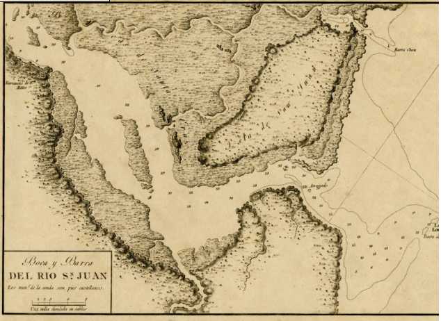
Below, a Spanish map of the Rio de San Juan (St. Johns River), from Barrancas de San Matheo, in the west (viewer's left map edge), to the river's mouth in the east (viewer's right map edge). Opposite, or north of Barrancas de San Matheo, are several river mouths called Bocas de Santa Cruz (mouths of the Santa Cruz in Spanish), flanked on the east by Isla de San Juan (island of San Juan). A small rectangle sits atop a height at Barrancas de San Matheo (Bluffs of San Matheo), perhaps a fortlet? Map title: Boca y Barra del Rio San Juan. 1809. T. Gonzalez, Madrid.
Below map: No. 15 (below No. 13), says Cano de Sta. Cruz y puanta de tierra firme. Perhaps this is the marsh area called Bocas de Santa Cruz (river mouths of Santa Cruz) on the 1809 map titled Boca y Barra del Rio de San Juan? That is to say opposite or north of Barrancas de San Matheo (no. 13) are the river mouths of Santa Cruz?
Below, an old engraving, circa 1671, showing an "imaginary "aerial view of Fort Caroline, based, apparently on eyewitness accounts of 1565? Of particular interest, is what appears to be the BARE ERODED CLIFF-FACE of today's Saint Johns Bluff, called by the Spanish "Barrancas de San Mateo" on maps of the 1700s made at Saint Augustine, Florida. Barrancas is a plural form of Barranca (Spanish for "Bluff"), suggesting more than one Bluff. Modern topographical maps (of a scale of 1:25,000) show TWO BLUFFS, adjacent to each other. A Frenchman who escaped the Spanish slaughter at Fort Caroline in 1565, said he fled eastwards towards French ships anchored at the mouth of the River Mai, when he encountered a high mount, with a very steep face, he clung to bushes growing on this face, hanging on for dear life, as he descended into the marshes below, to get to the French ships. This engraving also shows a range of mounts extending beyond the Bluff, and behind Fort Caroline, this is the high elevation shown on modern topographical maps (1:25,000) extending westward from today's Saint Johns Bluff. The 1565 Spanish account, called this height MONTE, meaning "mountain." (Stating some Frenchmen fled to the height of the adjacent MONTE and hid in the wooded slope). The French 1565 account also called this elevation MONT, again, meaning "mountain." Thus, the below engraving suggests that Fort Caroline is near the shore of the St. Johns River, and west of St. Johns Bluff. Regrettably, recent surveys of this area by the University of North Florida (2013), have so far failed to identify the remains of the fort to this day (2021). After capturing Fort Caroline the Spanish re-named it Fuerte de San Mateo (Fort Saint Matthew in English) and the River it was on, the French Mai, was re-named Rio de San Matheo, and still later Rio de San Juan (English: Saint John's River).
Below, a modern topographical map shows TWO BLUFFS. THE FIRST BLUFF has a parking lot atop it, for a view of the St. Johns River towards the east. At this parking lot a pillar has been erected to honor the French who explored this area 1561-1565. The SECOND BLUFF is just south of the riverside bluff, and has a modern road bisecting it. Extending west of the first bluff is high ground, apparently the mountains shown on the 1671 engraving (see above) which are behind Fort Caroline. A Spanish map made in St. Augustine in 1796 calls this high ground El MONTE. A Spanish map of 1809 calls these two heights Barrancas de San Mateo (scroll down for this map).
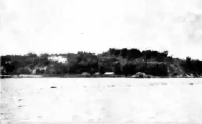
Below, an old photo of Saint Johns Bluff showing its eroded steep face on its east side.
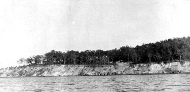
Below, an old photo showing the eroded cliff face of Saint Johns Bluff, which resembles the eroded cliff face on the above 1671 engraving of Fort Caroline.