Bered, Beer-la'hai-roi, Kadesh, Massah and Meribah, Mount Hor, wilderness of Zin, way of the Atharim (Map proposals for)
27 April 2010 (Revisions through 06 May 2014)
I realize that this article is going to be confusing for the reader. I am presenting "conflicting proposals" for locations for those interested in the subject and some of the problems encountered in site identifications (probably not a subject of interest for most casual readers). Perhaps one day someonelse will be able to sort out the conflicting proposals in this article and arrive at the correct sites? I must emphasize that part of the confusion, has been for me, inadvertenly caused by the Exilic author (ca. 562-560 BC) who confusingly presents the Edom's border as west of the Arabah as well as east of the Arabah. This confusion has been noted and commented on by various scholars. Also confusing is that I suspect that three different locations called Seir appear in the accounts: (1) The Judean Hill Country, (2) The "way to Seir" as the Darb es Shair'iah NW of Elath on the Gulf of Aqabah going N to the Hill Country, and (3) Seir/Edom on the E side of the Arabah.
Genesis provides numerous clues to the location of Kadesh in the wilderness of Zin. Most valuable, for me, is Genesis 16:14 RSV:
"Therefore the well was called Beer-la'hai-roi, it lies between Kadesh and Bered."
If Beer-la'hai-roi can be identified, Bered and Kadesh should be nearby.
A clue to Beer-la'hai-roi's (Beerlahairoi) location is that the well is spotted by Hagar while she is wandering in the wilderness of Beersheba:
Genesis 21:14 RSV
"So Abraham rose early in the morning, and took bread and a skin of water, and gave it to Hagar, putting it on her shoulder, along with the child, and sent her away. And she departed, and wandered in the wilderness of Beersheba...God opened her eyes, and she saw a well of water; and she went, and filled the skin with water, and gave the lad a drink."
Isaac dwelt at Beer-la'hai-roi:
Genesis 24: 62
"Now Isaac had come from Beer-la'hai-roi and was dwelling in the Negeb."
For other clues I have consulted Strong's Hebrew and Chaldee Dictionary for the Hebrew pronunciation of
Beer-la'hai-roi:
Strong 883, Be'er la-chay Ro'iy, be-ayr lakh-ah'ee ro-ee, from 2416 Chay, khah'ee, from 2124 Chayah khaw-yaw'; 7203 Ro'eh, ro-eh from 7200 Ra'ah, raw-aw, "to see".
Be'er la-chay Ro'iy might be Khirbet el Lekiyeh, while Ro'iy might be preserved at Khirbet el Ras just east of Lekiyeh (Ras is today on modern Israeli maps rendered as Rosh). If this be so, then Beersheba, south of Lekiyeh (cf. below maps showing a track descending south from Lekiyeh to Beersheba) is the "wilderness of Beersheba" Hagar was wandering in with Ishmael. That is to say perhaps Arabic Lekiyeh preserves the Hebrew pronunciation
la-chay, lakh-ah'ee, while Ras preserves Ro'ee? According to Stewardson (1888) khirbet Lekiyeh in Arabic means "the ruin of the encounter." I wonder if this is an allusion to the angel Hagar and Ishmael "encountered" at Beer-lahai-roi (Ge 16:7, 14)?
Accordingly, Bered might be Khirbet Bureideh north of Lekiyeh and Ras.
The Wilderness of Zin (Massoretic Zinah, Greek Septuaginta and Latin Vulgate Senna) might be preserved at Khashm Zanna, a prominent elevation ESE of Beersheba. I note that a track descends from Lekiyeh-Ras ending at Zanna. So Be'er la-chay Ro'iy is between Bered/ Bureideh to the north and Zanna/Senna//Zinah/Zin to the south. All the sites seem to line up with each other like ducks in a row in a shooting gallery and are near Beersheba (the wilderness of Beersheba extending apparently to Lekiyah-Ras).
Kadesh, in the Wilderness of Zin, might be Khirbet Abu Tellul el Medhbah. I note an Israeli map renders Medhbah as Mizbeh, could this be En Mishpat/Kadesh? Arabic b preserving Hebrew p? The t being lost?
Stewardson (1888) noted that Khirbet Bureideh might be Bered of the Holy Scriptures (he is referring to Vol 3, page 392 of The Survey of Western Palestine and its location on Map sheet 24 at map quadrants H & x):
"Bered, perhaps the ruin of Bureideh, III, 392."
"Kh. Bureideh, Sh. 24, Hx, 396, perhaps represents Bered, III, 392."
(p. 13. Henry C. Stewardson. Compiler. An Index to the Survey of Western Palestine. London. 1888)
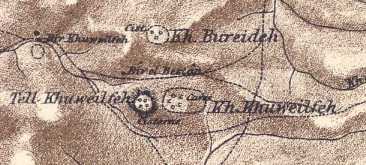
The below maps are of the 1878 Palestine Exploration Fund; khirbets Bureideh and Khuwelifeh, kh. Bureideh showing 3 cisterns (?) within a dotted circle N of kh. Khuwelifeh (Palestine Exploration Fund Map. Sheet XXIV, quadrants i & y. [apparently Stewardson's H & x] London. 1878)
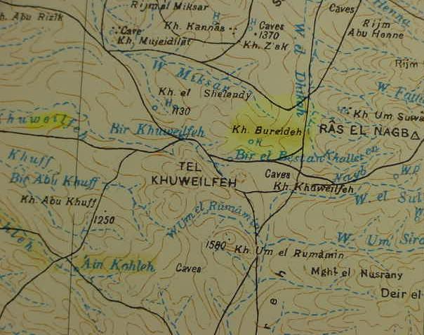
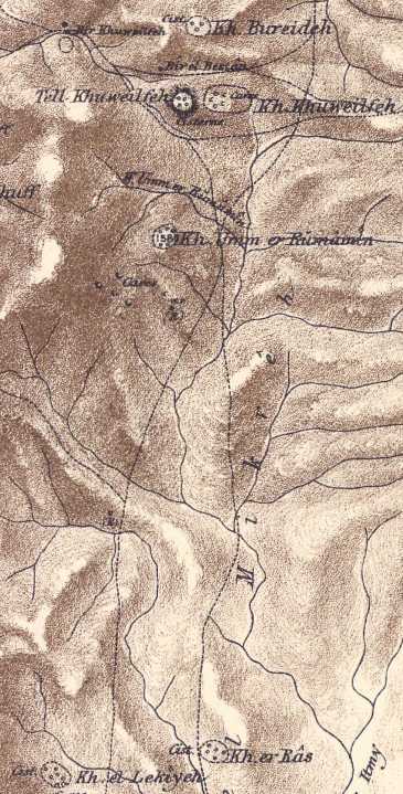
Below, same map, showing that the track going south from Bureideh splits into two tracks, going to khirbet el Lekiyah and khirbet el Ras, two sites preserving Hebrew Beer La-chay-ro'ee (la-chay, lachai), my proposal for Beer La'hai-roi where Hagar and Ishmael found a well. Like Burdeideh, Ras has a blue H and blue circle above it, perhaps the "well" of Hagar and Ishmael on the way from Bered to Kadesh?
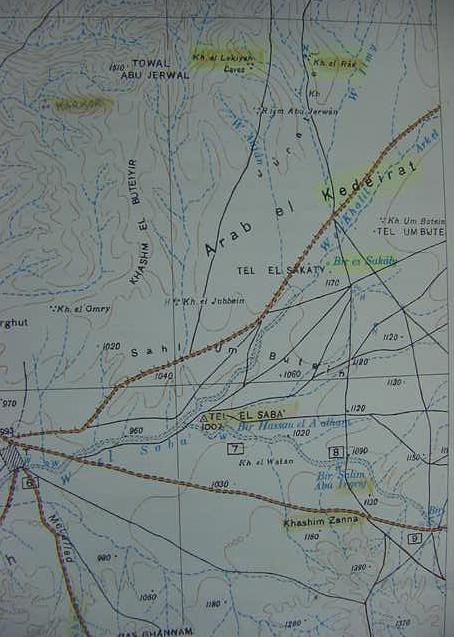
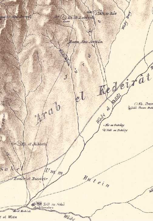
Below, from same above map, the track from khirbet el Ras goes south to Khashim Zanna, my wilderness of Zin/Zinah/ Sina/Senna. Kadesh-Barnea, Kadesh/en-Mishphat, or Meriboth-Kadesh should be nearby. Could Bir es Sakaty and Tel el Sakaty [highlighted] preserve Abraham's son's name, Isaac of nearby Beer La'chay-ro'ee (es-Sakaty is south of khirbet el Ras) or could it be Isaac's well of Esek (Es-Sakty=Esek?)?
Moses informs the king of Edom that Israel is camped _in_ Edom's border at Kadesh (Nu 20:14-16). Locating Edom's border would be a clue to Kadesh's location. I note that some of the below maps show Edom's northern border to be south of Beersheba and Arad and some maps suggest that the vicinity of Khashm Zanna was in Edom's border. If this be so then Kadesh-Barnea is "in" the northern border of Edom/Idumaea, WSW of Arad (Tell Arad) near Khashm Zannah.
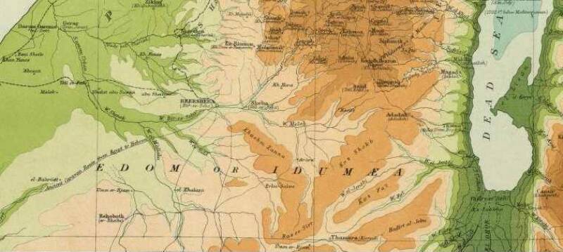
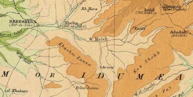
Below, two maps (1922. Palestine. Bartholomew. London. The Times) showing Edom's northern border to be south of Beersheba and Arad, Khashm Zanna (my wilderness of Zin/Zinah/Senna) is at the edge of this border:
Below, another map showing Edom's northern border to be south of Beersheba and Arad (Hormah being the name given the area about Arad in Nu 21:3) and embracing the area of Khashm Zanna (on other maps). Khirbet Abu Tellul el Medbah, Khurbet el Milh, and Jebel Tulul are also in Edom on this map. Edom's border ("toward the border of Edom in the south") is based on Joshua 15:21-32, which lists Beersheba and Hormah.
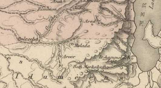
Below, another map showing Edom's northern border as being south of Beersheba and Arad (Arad's area called Hormah) placing Khashm Zanna (the area WNW of Aroer) within Edom's northern border (Molada is Arabic Milh):
Below, Kh. el Lekiyeh (Khirbet el Lekiyeh) north of Beersheba. El Ghurra (Beth Phelet for the cartographer), modern Israeli Tel `Ira (An Iron Age II settlement) is W of el Ghurra which might be Jagur (Joshua 15:21) said to be near Edom's border. It lies just SW of Arad (Palestine. 1901. Edward Stanford. London. scale: 1:684,288).
Below, El Lekiyeh north of Beersheba (Palestine. 1895. The Times. London. Richard Andree). If Khool , the root of Havilah, is preserved in Wadi Khulil, then the way to Shur (alternately called Havilah to Shur) is the track descending the Hill Country to Beersheba, thence on to Egypt and Shur.
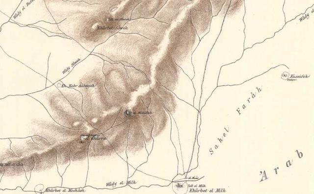
The biblical text confusingly states that Kadesh is in the wilderness of Zin and wilderness of Paran. If Zin be Khashm Zanna might Paran be preserved at Sahel el Farah in the drainage basin southwest of Arad? (For the below map, cf. The Palestine Exploration Fund Map. London 1878. Scale: 1:63,000. Sheet XXV)? If Meshash, meaning "cisterns" is Massah and Meribah (another name for Kadesh) could the five rock hewn cisterns have been recast by storytellers into Moses stricking a rock twice with his rod creating water for Israel's cattle? Cattle bones are documented for Tel Masos (1/3rd were sheep, 1/3rd goats, 1/3rd cattle) with similar ratios at Beersheba (Bir es Seba).
Seely on Zin/Zinah as Senna, brackets [ ] are mine:
"The Wilderness of Zin is not to be confused with the Wilderness of Sin. There is no distinction made in the [Greek] Septuagint or [Latin] Vulgate between Hebrew sin [diacritical dot under s] and sin (but see Num 34:4 and Josh 15:3, where Massoretic sina, "to Zin," is rendered "Senna" in both Septuagint and Vulgate)."
(p. 1096. Vol. VI. David R. Seely. "Zin, Wilderness of." David Noel Freedman. Editor. The Anchor Bible Dictionary. New York. Doubleday. 1992)
Perhaps the Greek Septuagint and Latin Vulgate texts' rendering of Hebrew Zinah into Senna was preserved in Arabic as Khashim Zanna?
Deciding on Kadesh's exact location is difficult. To the degree that some scholars on the basis of archaeological surveys suggest that Iron Age I (circa 1220-1100 BC) preserves best Israel's settling of the land under Joshua in Ramesside times Kadesh might be Tell Masos (khurbet el Meshash on the below map) as excavations reveal it is the largest Iron Age I settlement making it in my opinion the number one contender for Kadesh-barnea (Massah and Meribah).
However another possible site for Kadesh might be Khirbet abu Tellul el Medbah, west of Masos. Unfortunately I am not aware of archaeological excavations at Medbah. Medbah seems to be closer to the track descending south from Bureidah (Bered?) and Lekiyeh-Ras (Beer La'chai-roee?) ending at Khashm Zanna (the wilderness of Zin/Zinah/Senna?).
Masos/Meshash seems a bit further away from the track from Lekiyeh-Ras. However, if Meshash is Kadesh perhaps its location halfway between Sahel Farah to its east and Khashm Zanna to its west is why Kadesh is described alternately as being in the wilderness of Paran (Farah) and Zin (Zanna)?
Flavius Josephus (a Jewish historian of circa 80 AD) said Aaron's sister Miriam was buried at Zin which he said was a mountain. Is the elevation of Khashm Zanna (khashm means "height") Josephus' Mount Zin?
The king of Arad attacked Israel at Mount Hor in the edge of the land of Edom (Nu 33:37). If the above maps are correct in placing Edom's border just south of Beersheba and Arad might Mount Hor be Ras ez-Zuweira (es-Suweira on other maps)? It lies due E of Tel Masos and SE of Arad and is within striking distance of Arad. Israel retaliates and attacks Arad and her satellite villages calling the region/area Hormah. Beersheba, Kadesh, and Hormah do appear in Judah's south border near Edom (Joshua 15:21-29).
Numbers 33:36-37, 40 RSV
"...and encamped in the wilderness of Zin (that is Kadesh). And they set out from Kadesh, and encamped at Mount Hor, on the edge of the land of Edom...the Canaanite, the king of Arad, who dwelt in the Negeb in the land of Canaan, heard of the coming of the people of Israel."
Some may object to Edom's border being south of Beersheba and Arad, however, other scholars have noted that after Judah went into Exile circa 587 BC some of her lands were taken over by the Edomites to later become Idumaea by Hasmonean times (2d century BC). Some scholars understand Genesis-2 Kings was composed circa 562-560 BC in the Exile in Babylonia, this would be about 25 years or one generation in Exile. Perhaps the Exilic narrator of 562-560 BC was presenting to his "younger" Exilic audience (those under the age of 25?) a history of the nation in light of present Exilic realities they were familiar with, and could relate to, of an Edomite border south of Beersheba and Arad, placing Mount Hor, Kadesh, Zin, and Paran in this Edomite northern border?
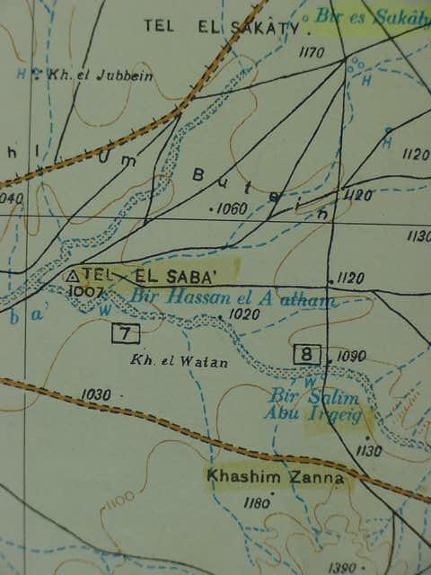
Below, a closeup of Khashm Zanna (Zin, Massoretic: Zinah, rendered by the Greek Septuaginta and Latin Vulgate as Senna) in the northern border of Edom/Idumaea. Note: Ancient Beersheba is usually identified with Tell es-Saba E of Bir es-Seba (Tell es-Seba is an Iron Age II settlement). Does Khirbet Hora preserve the Horites associated with Mount Seir (Ge 14:6)?
The site identifications presented here hinge upon the proper identification of Beer la'hai-roi (Be'er la-chay Ro'iy,
be-ayr lakh-ah'ee ro-ee) in the wilderness of Beersheba.
Apparently by 1888 khirbet Bureideh was recognized by some scholars as possibly being Bered of Holy Scriptures, and I concur. I only discovered this fact recently, today (29 April 2010) when it popped up on a Google seach for "Bureideh Bered" directing me to Stewardson's 1888 index compilation to The Survey of Western Palestine. I did not find in Stewardson Beerlahairoi listed, nor did I find khirbat Lekiyeh and khirbat Ras as preserving that name.
All the aforementioned proposed sites need to be archaeologically investigated to see if they were in existence no later than circa 562-560 BC when the account is believed by some scholars to have been composed in the Exile.
Some might object to my proposals on the basis that these sites are _not_ found on the Way to Shur, the Darb es-Shur, the caravan route from Jerusalem, Hebron, and Beersheba ending near Lake Timsah and Wadi Tumilat (Etham?) in Egypt. These sites lie to the north and south of this route. That is to say the Way to Shur is "flanked" on the north by Bureideh-Lekiyeh-Ras and on the south by Khasm Zanna while Beersheba (Iron Age II Tell es-Seba) is on the route.
From Kadesh Moses requests permission to cross Edom on the King's Highway, identified as the Darb es Sultan, (way of the king) which exends from Meshash to Jebel Madurah then across the Arabah to Edom. Edom refuses, so Israel "turns away to use another route, via Zalmona and Punon, the track from Meshash to Wadi es-Salmana S of the Dead Sea then to Punon (Fenian) on the western edge of Edom. This track, Zalmonah (Wadi es Salamani, near Edom, and just south of the Dead Sea, is called the way to the Red Sea and ends at Ezion Geber. This suggests that the way of the Atharim is the track going E from Tel Masos (Kadesh) to Ras es Suweira (Mount Hor). Just E of the Ras is Wadi Atrura, perhaps Atarim? That is to say the way of Atharim is the track heading in the general direction of Wadi Atrura which drains into the Dead Sea. A ford crossed this sea at Atrura. The way to Atharim then passed to the south of Arad going due east toward Atrura via Tel Masos, and Ras es-Suweira.
If the two khirbets of Lekiyeh and Ras preserve the name Beer la'hai-roi today in Arabic and If Bered is Bureidah N of Lekiyeh-Ras and if the wilderness of Zin (Zina, Senna) is Khasm Zanna, then Kadesh is possibly either Meshash/Masos, Medhbah/Mizbah, or Tell el Mihl, Edom's northern border being just below Arad and Beersheba (Tell es Seba being the ancient Iron Age II site) is correct.
As Israel's border begins at the lower bay of the Dead Sea then passes to the south of the Ascent of Akrabim to Zin
(Nu 34:3-4) perhaps the ascent is the track ascending from the area khirbet el Milh to Rugm el Kurabbeh (Akrabbim?) atop the mountain chain descending S and W of Arad (cf. The Palestine Exploration Fund Map. London 1878. Scale: 1:63,000. Sheet XXV)?
If all of the above is correct then apparently some biblical passages are describing Edom's north border of the 7th and 6th centuries BC, just before Judah went into Exile circa 587 BC under the Babylonians.
If scholars are right that Genesis-2 Kings was composed in its final form circa 562-560 BC in the Exile then perhaps the author presented the history of Israel in light of present realities of 562-560 BC to a younger audience (aged 20-25 years) who had grown up in the Exile who knew of an Edomite border just south of Beersheba and Arad?
He sometimes forgets himself and relates "correctly" at times the Edomite border as originally being east of the Arabah.
His "waffling" on this Edomite border (east of the Arabah vs. west of the Arabah and south of Beersheba-Arad) has lead to centuries of confusion for scholars, myself included, in determing the location of sites near an Edomite border like Mount Hor, Kadesh, Zin, and Paran.
Archaeology suggests Israel's pre-exilic Iron Age II border with Edom was further south if Jebel Halaq is correctly equated with Mount Halak the southernmost point conquered by Joshua. In fact, it ends near modern Quasaima, identified with biblical Azmon by some scholars (Azmon in the Targum being Kesam/Qesem) as two Iron Age II fortresses have been found near Qusaima (N of Ain Qusaima).
So, confusingly, two different borders may be preserved in the Bibe, a pre-exilic Judaean border as far south as perhaps Qusaimeh and the River of Egypt (Wadi el Arish?) and a 7th/6th century BC Edomite border at Khasm Zanna by Arad?
Other scholar's proposals for Bered:
Jewish sages suggested two sites for Bered, Chaghra and Chalutsah, neither of which are convincing for me (too far south of Beersheba to be in the wilderness of Beersheba):
"BERED (2) be'-red (beredh; Barad): A place in the Negeb mentioned in the story of Hagar (Gen 16:14). The well Beer-lahai-roi was "between Kadesh and Bered." The Onkelos Targum renders it Chaghra', which is the usual equivalent of Shur, while the Jerusalem Targum renders it Chalutsah, which is also Shur (Ex 15:22). Chalutsah is clearly the city of Elusu mentioned by Ptolemy and from the 4th to the 7th centuries by various ecclesiastical writers. It was an important town on the road from Israel to Kadesh and Mount Sinai. This is without doubt the very large and important ruin Kh. Khalasa, some 70 miles South of Jerusalem on the road from Beersheba and Rehoboth. "These ruins cover an area of 15 to 20 acres, throughout which the foundations and enclosures of houses are distinctly to be traced...We judged that here there must have been a city with room enough for a population of 15,000 to 20,000 souls" (Robinson, BR, I, 201)."
(E. W. G. Masterman, "BERED (2)." James Orr. General Editor. International Standard Bible Encyclopedia. 1915.)
Herion on Bered (1992) who probably understands Kadesh is either Ain el Qadeis (?) or Ain el Qudeirat (?):
"A place in the Negeb mentioned in connection with the story of Hagar (Gen 16:14). The well of Beer-lahai-roi is said to be located between Kadesh and Bered, but it is unclear in which direction it is located with respect to Kadesh. On the one hand Simons (GTTOT, 217) identifies it with Jebel umm el-Bared, SE of Kadesh. On the other hand, Targum Onqelos here renders Hagra, and the Targum Yerusalmi renders Halusa, each of which are also used respectively for Shur (Exod 15:22). Thus there seems to have been a tradition identifying Bered either with Shur (i.e. NW Sinai) or with the Way to Shur, therefore somewhere N of Kadesh. However, if Halusa refers specifically to Elusa -a town that has been identified with el-Khalasa (M.R. 117056) and that was occupied in Byzantine times (EAEHL, 359)- then there appears to have been a tradition locating Bered ca. 55 km NE of Kadesh (and 20 km SW of Beersheba)."
(p. 676. Vol. I. Gary A. Herion. "Bered." David Noel Freedman. Editor. The Anchor BIble Dictionary. New York. Doubleday. 1992)
Thompson on Beer-lahai-roi (1992):
"A location in S Palestine asociated with the birth of Ishmael (Ge 16:14) and mentioned twice (Gen 24:62; 25:11) as a residence of the patriarch Isaac...The location of Beer-lahai-roi is placed between Kadesh and Bered (Gen 16:14), that is, in the Negeb (so Gen 24:62). The water source which gave rise to the name was located on the way to Shur (Gen 16:7; see Shur, wilderness of)."
(p. 640. Vol. I. Henry O. Thompson. "Beer-lahai-roi." David Noel Freedman. Editor. The Anchor BIble Dictionary. New York. Doubleday. 1992)
The Interpreter's Dictionary of the Bible (1962) on Bered:
"2. A place on the road from Canaan to Egypt, beyond Beer-lahai-roi (Gen 16:14). The site is unknown, but the name may be preserved in the Wadi umm el-Bared."
Bibliography cited:
Martin Noth, Die israelitischen Personennamen (1928), p. 240; L. Kohler & Walter Baumgartner, Lexicon in Veteris Testamenti Libros (1953), p. 149.
(p. 386. Vol. 1. George A. Buttrick. Editor. The Interpreter's Dictionary of the Bible. Nashville & New York. 1962)
The on-line Catholic Encyclopedia Vol. 6 (Charles George Herbermann) states that Bered might be Umm el-Bared SE of Cades (Kadesh) [apparently -?- Jebel Umm el-Bared SE of Kadesh (Ain el Qadeis? or Ain el Qudeirat?].
For me the "problem" of Bered being SE of Ain el Qadeis or Ain el Qudeirat is that this appears to be too far south of Beersheba to qualify Beer-lahi-roi as being _in_ the wilderness of Beersheba and Kadesh being near Edom's border with Israel. The king of Arad attacked Israel at Mount Hor "in the border of Edom" and Moses said Kadesh was
"in Edom's border," suggesting for me that Mount Hor was very _near_ Arad for an attack. Thus I prefer Zin, Paran, Kadesh, and Mount Hor to be near Edom's northern border just south of Arad and Beersheba as portrayed by some of the maps presented here (cf. the above maps).
Below, the map location of Beer-lahai-roi according to two Israeli scholars (1968-1993) Aharoni and Avi-Yonah, perhaps based on Rowland's 19th century AD proposal that Ain Muweileh near Qusaima is the site? (p. 43. Map No. 44. "Abraham and Isaac in the Land of Canaan." Yohanan Aharoni & Michael Avi-Yonah. The Macmillan Bible Atlas. Jerusalem. Carta. 1968-1993)

Below, the same map location (?) for Beer-lahai-roi by Beitzel (p. 83. Map No. 23. "Abraham's Travels in Canaan." Barry J. Beitzel. The Moody Atlas of Bible Lands. Chicago. Moody Press. 1985)
If my proposal for Zin/Senna being Khasm Zanna SW of Arad is correct then the ascent of Akrabim between the Dead Sea and Zin might be the track ascending the mountain spur west of Arad, the name Akrabim perhaps being preserved at Rugm Umm el Kharrubeh?
Numbers 34:3
"...your south side shall be from the wilderness of Zin along the side of Edom, and your southern boundary shall be from the end of the salt sea on the east; and your boundary shall turn south of the ascent of Akrabbim and cross to Zin; and its end shall be south of Kadesh Barnea..."
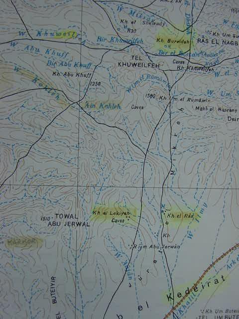
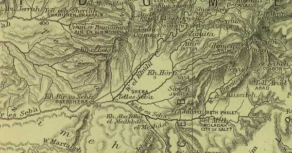
Below, panoramas of the track(s) between Bureideh to the north and Lekiyeh-Ras to the south; the roads meet again in the vicinity of Beersheba where they join the Way to Shur caravan track between Jerusalem, Hebron, and Beersheba, crossing the Sinai to end near Lake Timsah and Wadi Tumilat (Etham?) and Bir Abou Suwayr, perhaps biblical Shur (Hebrew: shuwr) which is on this track on the N side of Wadi Tumilat, a little W of Lake Timsah. Kh. el Lekiyeh and Kh. er Ras on the map to viewer's right are near the top, north of Arab el Kedeirat and Beersheba. Both of the tracks going south from Lekiyeh and Ras intersect and join the great caravan route from Jerusalem to Hebron and Beersheba, "the way to Shur" going to Egypt associated with Hagar and Ishmael's wanderings. The bible speaks of Amalekites being pursued from Havilah to Shur (1 Sa 15:7) that is before Egypt, and some scholars have proposed Havilah's root to be khool. Could Khool be preserved in Arabic as Wadi Khulil which drains to Bir es Seba (ancient Beersheba) from the NE? If so, then the way to Shur begins at Wadi Khulil, in the Hill Country, goes to Beersheba and ends at Shur before Egypt. Hagar's wandering in the wilderness of Beersheba, near the way to Shur, is, then, at Lekiyeh-Ras, which I have proposed as being Beerlahairoi.
The below three map images are from a map titled Beersheba. 1:125,000. Sinai Peninsula. Part of Sheet E. IV, Beersheba. Said map being in the Atlas of Israel. Produced by the Survey of Israel. Jerusalem. 1972. Bureideh, my proposal for Bered. Note: I was unaware that earlier scholars had proposed Bered might be Bureideh. I discovered today on 29 April 2010 that this identification appears in Stewardson's 1888 Index of The Survey of Western Palestine.
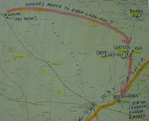
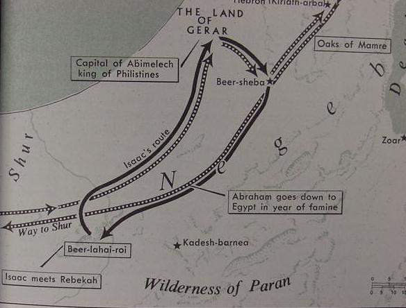
Below, _my proposal_ for the route Hagar may have taken with her young son Ishmael from Abraham's camp at Gerar to Beer-la'hai-roi. Gerar is currently identified with modern Israeli Tel Haror (Arabic Tell Hariera on the map). It is 4 acres in size and occupied since Bronze Age times (a Philistine presence of the Iron Age is documented here). If this site is Gerar then Hagar probably wandered E following Wadi Sharia (modern Israeli Nahl Gerar) then S to khirbets Lekiyeh and Ras (Beer La'hai-roi?) which lies just N of the Way to Shur (a caravan route from Jereusalem to Wadi Tumilat, Egypt via Hebron and Beersheba). Bered might be khirbet Bureideh N of Lekiyeh-Ras (Beer La'hai-roi?) and Kadesh would be in Khasm Zanna (the wilderness of Zin, Zina, Sanna?) SE of Beersheba (Iron Age II Tel es-Saba).
The Revised Standard edition of the Bible, for me, suggests Kadesh and Zin might have been interchangeable terms for the same area, if so, then perhaps Zin/Kadesh is Khasm Zanna (Massoretic Zinah, Septuagint and Vulgate Sanna)?
Numbers 33: 36-37 RSV
"And they set out from Ezion-geber, and encamped in the wilderness of Zin (that is, Kadesh). And they set out from Kadesh, and encamped at Mount Hor, on the edge of the land of Edom."
Another "possibility" for Bered is khirbet Barrata (Abraham's Gerar being Modern Israeli Tel Haror W of Tell es Sharia; Hagar and Ishmael perhaps wandered E of Gerar to the wilderness of Beersheba to Beer-lahai-roi, khirbets Lekiyeh (Lekije) and Roi (Ras), between Bered (Barrata?) and Kadesh, Khashm Zanna (?) S of Iron Age II Tell es Saba through which passes the "way to Shur" the great caravan route from Jerusalem to Hebron, Beersheba ending at Wadi Tumilat (biblical Etham?) in Egypt and Bir es Suwayr ("Shur that is before Egypt"?) on the N side of wadi Tumilat. That is to say the "wilderness of Kadesh" might be El Kaderat. Khasm Zanna, perhaps (?) the Greek Septuaginta and Latin Vulgate's Sanna after the Massoretic Zinah/Zin-ah.
If these proposals be "correct" then the "wilderness of Zin/Kadesh" (Nu 33:36) that Israel camped at with Moses was "back in the old stomping grounds" of the patriarchs: Abraham, Isaac and Israel, the area about Beersheba, the well dug by Abraham's men. That is to say Kadesh/Zin is _not_ at Ain el Qadeis nor Ain el Qudeirat where most scholars assume they are for the past 150 years.
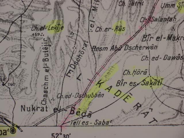
Below, a close-up of Lekiyeh-Ras (Ch. el-Lekije and Ch. er-Ras) my proposal for Beer-lahai-roi. Could Bir es Sakati be the "well of Isaac," Isaac "dwelt" at Beer-lahai-roi or its vicinity and Sakati is somewhat near Lekiyeh-Ras (Beer-lahai-roi)? Is Hormah ch. Hora, a location Israel was routed to from Seir by Hill Country defenders (Nu 14:45)? Seir might be Umm Sire (upper right corner of the below map)?
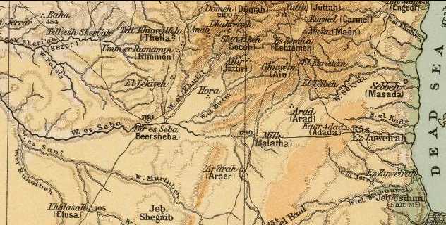
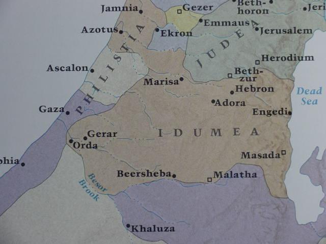
Below, a map showing Post-Exilic Idumea (Edom) of the 2d century BC. Edom seized the Hill Country area with the fall of Jerusalem to the Babylonians circa 587 BC and claimed it in Exilic (ca. 587-539 BC) and Post-Exilic times (after 539 BC).
I "suspect" that the Exilic writer (562-560 BC?) is envisioning Israel's request "to cross Edom" to to get to the Promised Land and Canaan via the King's Way as an Israel camped at Zanna (Zin/Zina/Senna?) on Edom's _north_ border and when access is denied by an armed Edom Israel "turns away" (Nu 20:1, 14, 16--21) and stops at Mount Hor (Ras es-Suweira SE of Arad?) to bury Aaron (Nu 20:22-23) when attacked by the king of Arad (Nu 23:1-4).
After destroying the Arad area in revenge and calling the destroyed area Hormah (Nu 21:3, preserved perhaps at Deirerat el `Araime E of Arad?) Israel continues ESE to the Arabah to connect up with the "way to the Red Sea" and Elath (Arabic: Aila by the port of Aqaba). Here, the narrator picks up again on Edom being on the E side of the Arabah (Nu 21:4). I understand that Israel's route from Mt. Sinai to Kadesh via "the way of Mount Seir to Kadesh-barnea" is alluding to the Darb esh- Shaira, a track going North from the Sinai to the Hill Country via Gebel esh-Shaira which is WNW of modern Israeli Elath. In other words there is more than one place called Seir in the Bible. (1) Seir east of the Arabah, (2) Seir west of the Arabah, enroute from Sinai to the Hill Country, and (3) Seir in the Hill Country.
(for the below map cf. p. 155, Map 73. "Growth of the Maccabean Kingdom." Barry J. Beitzel. The Moody Atlas of Bible Lands. Chicago. Moody Press. 1985)
Another possible candidate -for me- for Kadesh-Barnea is Khirbet el Mihl (modern Israeli Tel Malhata) as it was occupied in the Iron Age from the 10th to the early 6th centuries BC (Mashash/Masos being occupied in the Iron Age from the late 13th to the beginning of the 6th century BC):
"By the Chalcolithic period there was already a settlement...In the Early Bronze Age II a larger settlement...Middle Bronze IIB...the first fortified settlement...an area of some 2.5 a...destroyed...In the Late Bronze Age there was no settlement in the Beersheba-Arad valley...Malhata was rebuilt in the 10th century BCE...This construction is undoubtedly related to the disappearance of the earlier large center at Tel Masos in the heart of the valley. By the 10th century BCE Malhata was the largest Israelite settlement in the valley...it...retained its status as the largest and best-fortified city in the Beersheba Valley until the establishment of the Israelite cities at Tel Ira and Aroer on the hills to the north and south of the valley. The site's last Iron Age settlement which shows signs of Edomite influence...was destroyed at the beginning of the 6th century BCE."
(pp. 934-937. Vol. 3. Moshe Kochavi. "Malhata, Tel." Ephraim Stern, Editor. The New Encyclopedia of Archaeological Excavations in the Holy Land. New York. Simon & Schuster.1993)
Against Milh being Kadesh is that it is Iron Age II. One would expect that if scholars are correct that Iron Age I (1200-1000 BC) is Israel settling in Canaan, then Kadesh ought to be an Iron Age I site. Tell Masos (Meshash) fits that billing and it is also the largest Iron I site as well in this region. It is also near the Hill Country and in view of this area, and near Mount Hor (if Tell Ghurra is Hor ha Har), and near Arad, for retaliatory strikes.
Note: Modern Israeli Tel Ira is the 6 acre Iron Age II settlement of Tell Ghur W of el Ghurra. Beit-Arieh stated Tel Ira (1878 PEF Map's Tell Ghur) had evidence of an occupation in Early Bronze Age III (27th-23rd century BC) and Iron Age II (late 10th to late 7th century BC), several rock-hewn tombs were found on the E slope. Beit-Arieh noted several proposals for its biblical name but concluded its identity is still a mystery (proposals being Kabzeel, Ramah, Eltolad).
"Tel 'Ira (in Arabic, Khirbet Ghara) is situated in the Beersheba valley, in the Negev desert, on a tablelike chalk hill 514 m above sea level...This hill is the south end of a spur of the Hebron Hills. The site...is slightly more than 6 a., covers the entire hill, which is quite steep and isolated. It is surrounded by an Iron Age stone wall whose entire length has been exposed...Aharoni favored the view that Tel 'Ira had been the capital of the Negev province during the Iron Age II."
(pp. 642-646. vol. 2. Itzhaq Beit-Arieh. "Ira, Tel." Ephraim Stern, Editor. The New Encyclopedia of Archaeological Excavations in the Holy Land. New York. Simon & Schuster.1993)
I could find no archaeological report for my 3rd candidate for Kadesh-Barnea, Medhbah (Israeli Horvat Mizbah, S of Mashash/Masos).
I realize that all this must be somewhat "overwhelming" and _confusing_ for the reader.
I am presenting "conflicting proposals" (euphemistically called "brain-storming") for locations for those viewers interested in the subject of Arabic toponyms (place-names) and the problems encountered in biblical site identifications (probably not a subject of interest for most casual readers).
Perhaps one day someonelse will be able to sort out the conflicting proposals and arrive at the correct sites? As is obvious by my proposals at this website I am _not_ in agreement with PhD scholars on the locations of "certain sites" that a scholarly consensus has accepted over the past 100 years.
This all began with an attempt to identify Beer-lahai-roi!
A "spin-off" of this attempt was the realization that "if" Lekiyeh-Ras preserves Beer-Lakhy-Ro'ee (Beer-lahai-roi) then Kadesh is probably nearby, its not at far-off Ain el Qadeis nor Ain el Qudeirat where the scholarly consensus places Kadesh for over 100 years!
To establish Kadesh as near Beersheba's wilderness and Beer-lahai-roi other sites associated with Kadesh and ZIn had to be identified. It is the preponderant weight of other localities whose names are similar as Arabic toponyms that identify Kadesh, Zin, Paran, Hormah and Arad.
Again, I must emphasize that part of the confusion, is, for me, caused by the Exilic author who unintentionally but confusingly presented an Edomite border as being both east and west of the Arabah shortly before Judah's fall to Babylon.
As regards the Edomite border Kadesh/Zin is said to be "in":
(1) After being denied access to the King's Highway to cross Edom from Kadesh to get to Canaan Israel "turns" and heads for the Red Sea, enroute, the king of Arad attacks her at Mount Hor. If Mount Hor is Gebel Madura on the W edge of the Arabah and the "King's Way" is the Darb es Sultani, this is for me, too great a distance for a strike from Arad. If Mt. Hor is Gebel Harun near Petra on the E side of the Arabah, again, for me, the distance is too great for a strike from Arad. For me an ideal striking distance at Mount Hor from Arad would be not more than 20 miles.
(2) After turning away from Edom's border near Khashm Zanna (Zin/Kadesh) and heading eastwards (?) towards Arad, Israel stops at Mount Hor in the edge of Edom's land. The king of Arad, aware of Israel's approach to his area E of Mount Hor/Tell el Ghurra apparently makes a pre-emptive attack. After Israel's retaliation strike on Arad she contuinues on with her eastern trek from Khashm Zanna (Zin/Zina/Senna?) to the Arabah south of the Dead Sea and descends along the Arabah's east side skirting the foothills of pre-Exilic Seir till she reaches Elath (Arabic Aila near the port of Aqaba) where she turns then ENE towards Moab.
If asked to pick between Bureidah or Barrata for Bered, I favor Bureidah.
I favor Zin/Kadesh (Khashm Zanna/Zanne) and nearby Mount Hor (Ras es-Suweira) to be in the vicinity of Arad they being "closer" for an exchange of strikes than a "far-off" Ain el Qadeis and Ain el Qudeirat or a yet farther-away Gebel Harun by Petra.
I favor Kadesh/Zin (El Kaderat/Khashm Zanna) to be in Edom's _south_ border from Beersheba to Arad; the wildernesses of Zin and Paran flank el Ghurra on its SW and E sides: On the SW: the wilderness of
Zin/Zina/Senna= Wadi Khashm Zanna/Zinneh; on the E: the wilderness of Paran = Sahel Farah SW of Arad.
The Israelite camp would be near the "mountain of the Amorites" alternately called the Negeb and the Hill Country of Seir/Edom. Seir being preserved at Umm Sire/Sira SW of Attir and at Umm es-Saiyar S of Attir, also at Ras es-Sira.
To the degree that Iron Age I (1220-1100 BC) best fits the biblical portrayal of the settlement of Canaan under Joshua (even with all the archaeological anomalies like deserted sites and locations not existing until the 8th-6th centuries BC) Tel Masos (khirbet Meshash el Milh) might be Moses' camp as it is the "largest" and earliest Iron Age I settlement in the Negev. If this be so, Hazar-addar might be Iron Age II Ain el Qudeirat on the track descending SW from Masos.
I agree with those PhD scholars who hold that Genesis-2 Kings was composed in the Exile ca. 562-560 BC and thus for me sites can appear in these texts that archaeologically are as late as 562-560 BC.
Not until Sir Flinders Petrie (1890s) and his successors developed pottery chronologies to date sites by did anyone know the "real age" of any site in Egypt, the Sinai, Negeb, Edom, Moab or Canaan.
For the anonymous Exilic composer of Genesis-2 Kings, any site in existence in his day, 562-560 BC, could be a site which existed in Moses' world and Exodus of either 1519, 1446, or 1260 BC (popular dates for the Exodus).
Accordingly, Stone Age, Early Bronze Age, Middle Bronze Age, and Iron Age sites could be _mistakenly_ "assumed" by the Exilic author of Genesis-2 Kings as being in existence at the time of Moses' Exodus and undoubtedly were so identified based on the archaeological findings!
The Exodus -as presented- in the Bible is a myth. Some of the sites mentioned in the Exodus and Conquest of Canaan account were not in existence until the 8th-6th centuries BC, other, earlier sites were abandoned (Early Bronze Age Arad by 2300 BC was deserted when the Exodus occurred (1519, 1446, 1260 BC) a fact neither the Exilic author nor his audience were aware of.
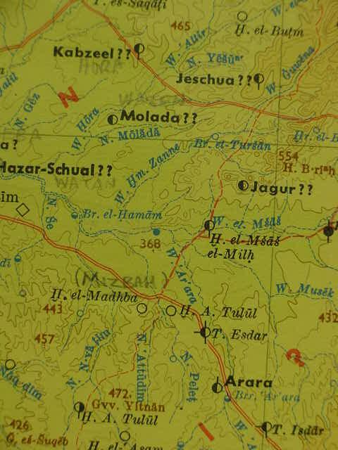
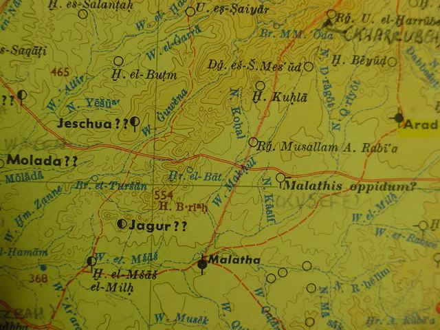
Below (Hohne's Palastina Karte, Sud Blatt 1979), Wadi Hm. Zanne (W of Jagur) might preserve Zin, Zina, Senna, as a water source. Jagur is the German rendering of Tell Ghur (an Iron Age II settlement W of El Ghurra). Note: German "J" is pronounced Yah, similar to Hebrew Yah, as for example English Jerusalem is an incorrect spelling and pronunciation of Hebrew Yerusalem (in turn an incorrect rendering of Canaanite Urusalem of the Tell el Amarna tablets).
Khasm Zanna at first glance seems not to appear on the below map. The map shows a W. Hm. Zenna W of Jagur and N of H. el-Madhba (modern Israeli: Horvat Mizbah). The Hm. is an abbreviation for Arabic Khasm (German "spitz") a height or elevation. So apparently other maps' Khashm Zanna is somewhat preserved in the Wadi Khasm Zenna, "river of the Height of Zanne." If Zanna/Zanne preserves Zin, Zina, Senna then Israel at Kadesh/Zin is very near el Ghurra (Hohne's H. B.riah 554) my proposal for Hor ha Har or Mount Hor in the edge of Edom which was within striking distance of Arad (Ernst Hohne & Hermann Wahle. Palastina Historisch-Archaologische Karte. Sud Blatt. 1979. Gottingen. 1:300,000) this map plots the confirmed archaeological periods for sites Stone Age to Mamluk times. H. el-Madhba is modern Israeli Horvat Mizbah, could this be En Mishphat an alternate for Kadesh? If so, then the red dotted track south of Madbah might be Judah's south border headed for Hazar-Addar (Ain el Qudeirat). Israel is essentially claiming the Beersheba drainage basin beginning just E of Arad as being her territory under this proposal.
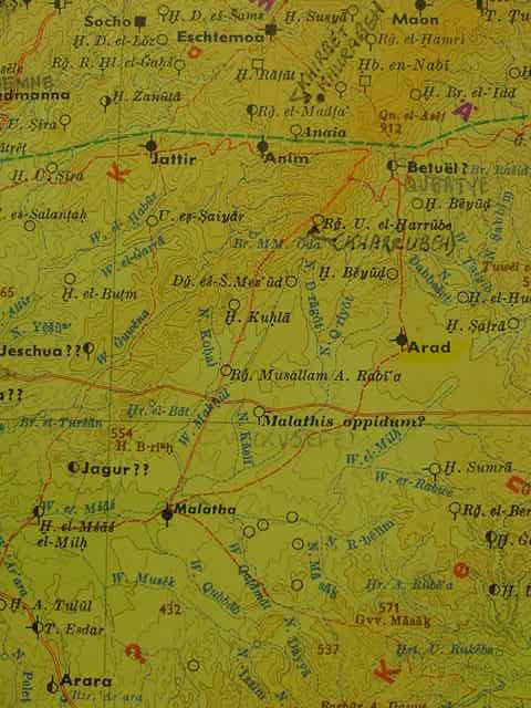
If Zin/Kadesh is Khashm Zanna/Zenne then Judah's south border, skirting Edom's border (Nu 34:3-5) is from the lower bay of the Dead Sea westward to cross just S of the Ascent of Akrabbim, perhaps the track ascending N from Tell el Milh (modern Israeli Tel Malatha) to Rugm Umm el Kharrubeh (Hohne's Rg. U. el-Harrube) WNW of Arad, then the border passes to the south and terminates at Zin, Khashm Zanna, and Wadi Khashm Zanne adjacent to and WSW of el Ghurra/Mt. Hor. From Zin the border turns to go S to Hazar-addar, perhaps the Iron Age fortress at Ain el Qudeirat? Hazar means "walled" or "enclosed" settlement and Qudeirat is walled. From Hazar-Addar the boundary went to Azmon (Nu 34:4-5) to the Brook of Egypt (Wadi el Arish headwaters draining the Qusima area (The Targum's Azmon being Kesam) two Iron Age II forts exist near Qusaima. Egypt or Mizr, Mitsrayim (Neo-Assyrian Musri) might be preserved at Gebel Musraq/Musrag W of Qusaima. Note: Se'ir (an alternate name for Esau and Edom) might be preserved at Umm es-Saiyar/Seir S of Jattir and N of Jagur/Tell Ghur or at H. U. Sira W of Jattir (khirbat Umm Sira). Either Umm Sira or Umm Saiyar (Umm Seir on the 1878 PEF Map) might be the Seir Israel was routed from to Hormah (khirbet Hora? SW of H. U. Sira).
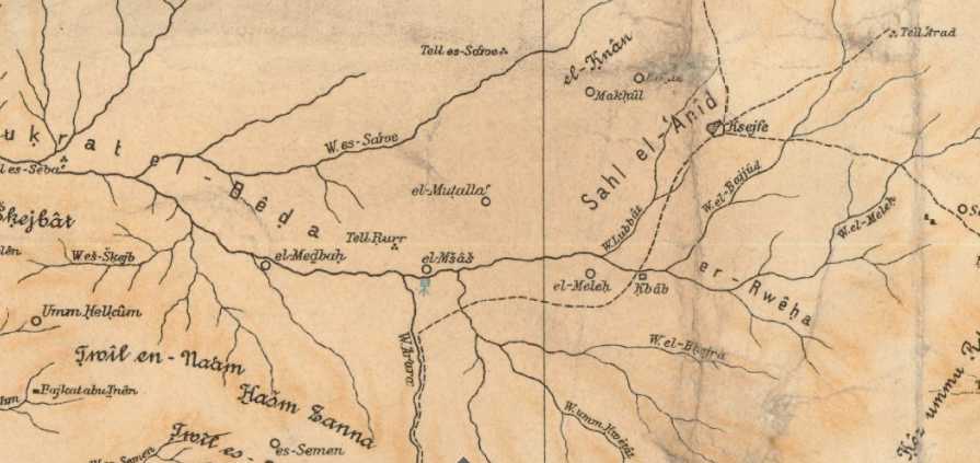
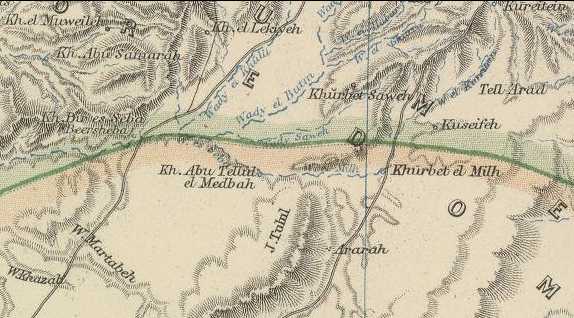
Below two maps (1907) Tell Rurr (1878 PEF Map's Tell Ghur) W of el Ghurra (not on this map) my proposal for Jagur, Medbah (modern Israel Horvat Mizbah) and el-Msas (M=other maps' Meshash), el-Meleh (other maps' Tell Milh, Malata) on the below map (Alois Musil. Karte von Arabia Petraea. Vienna. 1907). I understand Hasm (khasim) Zanna preserves the Septuagint's Senna (also rendered Senna by the Latin Vulgate Bible), the wilderness of Zin in the border of Edom, where lay Kadesh-barnea (Massa and Meribah), my el-Msas (today's Israeli Tel Masos).
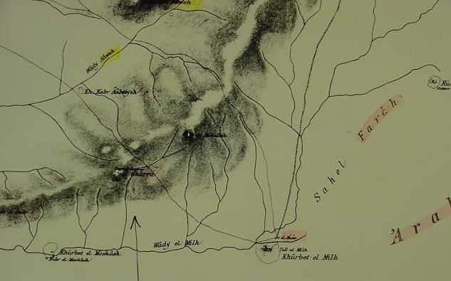
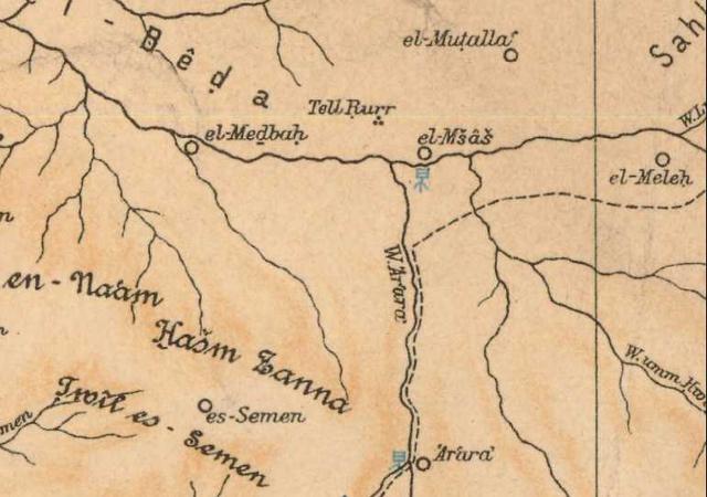
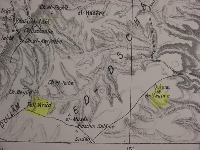
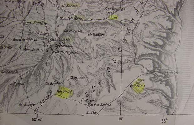
Below, Tell Arad is in the upper right corner of the below map, a track heads W from Arad to Khashm Zanna (my wilderness of Zin/Zina/Senna). Moses' camp at Kadesh-barnea might be either el-Msas (modern Israeli Tell Masos) or el-Medbah (Modern Israeli Horvat Mizbah), both sites lie in the drainage basin in the midst of two elevations or heights: to the N: Tell Rurr (1878 PEF Map's Tell Ghur, Israeli Tel 'Ira) and to the S Khashm Zanna (Zin).
Why am I locating Kadesh near Arad and the Hebron Hill Country instead of at Ain el Qadeis or Ain el Qudeirat where the scholarly consensus places it for the past 150 years?
A detective to solve a mystery gathers up clues. The clues for me:
(1) Kadesh appears to be for me near Beer-lahai-roi, which, in turn, is "in" the Wilderness of Beersheba and Beersheba is W of Arad.
(2) Bered is perhaps Bureidah, Beer-lahai-roi is perhaps Lekiyeh-Ras N of Beersheba (Tell es-Saba) so Kadesh is near by.
(3) Kadesh appears to be an alternate (?) name for the wilderness of Zin (Nu 33:36); if Lekiyeh-Ras is Beer-lahai-roi in the wilderness of Beersheba and Buriedah N of Lekiyeh-Ras is Bered then Kadesh is probably S of Lekiyeh-Ras. I find S of Lekiyeh-Ras a track going to Khashm Zanna perhaps preserving Masoretic Zina, Septuaginta and Vulgate Senna and conclude that Kadesh/Zin is SE of Beersheba (Tell es-Saba) and SW of Arad.
(4) From Mount Horeb in the wilderness of Sinai Kadesh/Zin is reached via "the way to Seir" (De 1:19-20) and Israel leaves Kadesh/Zin to ascend into the Negeb Hill Country to be defeated _in_ Seir (De 2:44-45), apparently their are two Seirs, Gebel Esh-Shaira and its Darb esh-Shaira NW of Elath and Seir in the Hill Country from which Israel was routed from to Hormah (De 1:2).
(5) So at least one Seir is in the Hill Country.
(6) Israel's rout in the Hill Country of Seir ends at Hormah (De 1:44), Israel calls the region about Arad and her settlements Hormah (Nu 21:3) suggesting for me that Hormah is near Kadesh/Zin/Paran. I note that Arad and its settlements are on a high plateau W of the Dead Sea. Ascending this plateau from the Dead Sea one encounters an elevation called Dahrat el-`Araime (439 feet). It is my proposal that as Arad shares this high plateau with `Araime that Hormah is perhaps preserved at `Aramie. So Horma is perhaps the high plateau about Arad extending E to W from `Araime to Sahel Farah N of Tell Milh.
(7) Mount Hor (Hebrew: Hor ha Har) is perhaps Ras es-Suweira SE of Arad and it is within easy striking distance of the king of Arad and borders the Arad region called Hormah.
(8) After destroying Arad and its settlements Israel calling the region Hormah, Israel quits Mt. Hor and proceeds on to the way to Yam Suph (the way to the Red Sea or Gulf of Aqaba).
(9) After Arad/Hormah's destruction Israel leaves Mount Hor (Mt. Hor should be near Arad for the exchange of strikes) and camps at Zalmonah, perhaps Wadi Salamana in the Arabah valley south of the Dead Sea? Salamana is near the eastern foothills of the mountains forming the Arabah's east border. Salamana is ESE of Arad and `Araime.
(10) From Zalmonah/Salamana Israel camps at Punon (Greek Septuaginta Phaino) modern Arabic Fenian which lies S of Salamana. Feinan like Salamana lies near the eastern foothills of the Arabah valley.
(12) The Exodus account was not written by Moses (1519 BC, 1446 BC, 1260 BC Exodus), it was composed circa 562-560 BC (cf. 2Ki 25:27 in the reign of the Babylonian king Evil-Merodach) in the Exile and addressed to a Exilic audience. This narrator recalls shortly before Judah's fall, that Edom had occupied the area south of the Hill Country, and archaeologists have found evidence of this Edomite presence in the region in the 7th and 6th centiries BC. This fact may explain why the Exilic narrator portrays Edom confusingly at times as W of the Arabah as well as E of the Arabah.
Below, the high plateau Arad is upon which begins E of Arad at Dahrat el-`Araime, elevation 438 feet above sealevel.
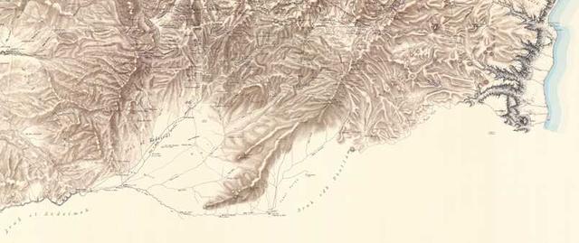
Below, a panorama of the high plateau Arad is on. This plateau is bordered on its W side by the mountainous spur extending SW of Arad. This spur ends at el Ghurra (not on this map) my proposal for Mount Hor. Israel was defeated in the Hill Country and routed from Seir to Hormah and Arad and its settlements was called by Israel Hormah, suggesting Mount Hor, Kadesh, Zin, Paran are all near Arad-Hormah, Arad-'Araime (Map title unknown, but bears the following information in German: Bearbeitet in der Kartogr.Abeilung der Kgl. Preuss Landes-Aufnahme. April 1918)
Below, Khashm Zanna (Zin, Zina, Senna?) to viewer's far left (not on this map but appears on other maps) across from and WSW of the end of the Hill Country Spur. Khashm Zanna "the height of Zanna" forms the S side of the valley that the headwaters of wady Beersheba drain from. Zannah is S of the spur. The Iron Age II settlement of el Ghur (Israeli Tel 'Ira, Hohne's Jagur), W of el Ghurra on this spur NE of Medhbah, N of Meshash/Masos and NW of Tell Milh; a track passes by the E side of el Ghurra on the below map going to Milh. Arad or Tell Arud is the elevation spot at "the end" of the word Arab edh Dhullam. Kadesh is sometimes described as in the wilderness of Zin (Massoretic: Zina, Septuaginta and Vulgate Senna) and the wilderness of Paran. If Khashm Zannah at the W tip of the spur is Zina perhaps the wilderness of Paran also associated with Kadesh is Sahel Farah E of Tell Milh and the spur (W of the word Arab edh Dhullam). If Sahel Farah preserves Paran then the campsite of Kadesh-Barnea could be any of three sites:
(1) Medhbah/Mizbeh, (2) Meshash/Mashash or (3) Milh/Molada as they are S of the Hill Country Spur. This spur is flanked then on its SW side by Khashm Zanna (the wilderness of Zin/Zina/Senna?) and on its E side by Sahel Farah (the wilderness of Paran?) (Map sheet XXI. Palestine Exploration Fund. London. 1878). If the high plateau Arad is on is Hormah preserved at 'Araime, the PEF map's Dharet el `Araimeh vs. the German map of 1918 Dahrat el-`Araime, then Hormah/`Araimeh ends on its W side at the southernmost spur el Ghurra is on. Sahel Farah, if it is the wilderness of Paran, is a part of the high plateau of Hormah/`Araimeh. Thus Israel's rout from Seir (the Hill Country abutting the N side of the Hormah/`Araimeh plateau) to Hormah then a return to Kadesh (Nu 14:45) places Kadesh very near Arad and Hormah/`Araimeh plateau.
Below, the above map in a panoramic form from Beersheba in the W to `Araimeh in the E and the Dead Sea (blue area) showing more clearly the southernmost spur of the Hill Country of Seir ending at Khashm Zanna (Zin/Zina/Senna?) in the W and Sahel Farah (Paran?) along the E side of the spur.
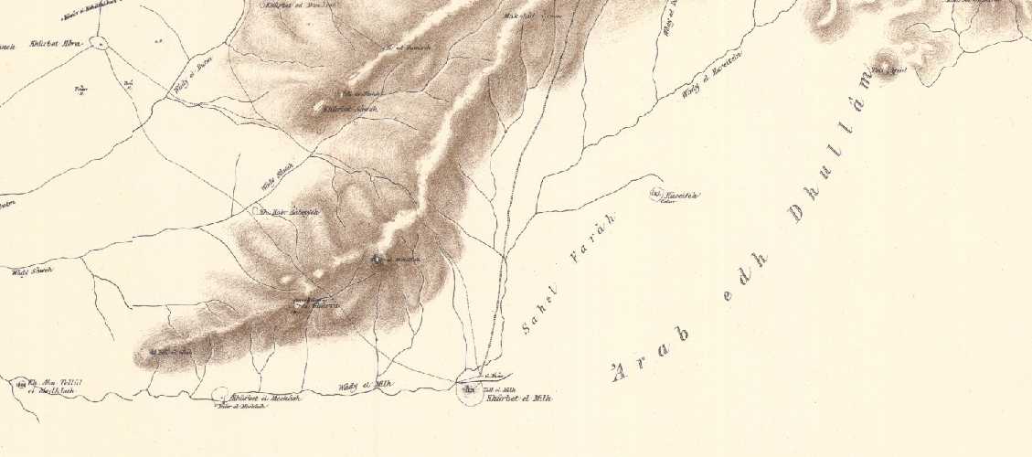
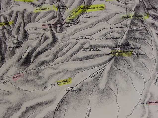
Below, a close-up of Sahel Farah my proposal for the wilderness of Paran associated with Kadesh. El Ghurra (my Mount Hor) has caves and cisterns and a track passes its E side headed for Tell Mihl. El Ghurra's mountainous spur lies W of Sahel Farah on a track crossing the spur headed for Tell Mihl/Moladah a possible candidate for Kadesh-barnea (along with two other candidates: Medhbah/Mizbah and Meshash/Masos)
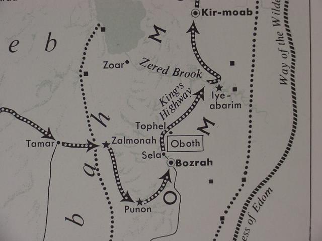
After destroying Arad and its settlements and calling the area Hormah, Israel apparently finishes its mourning for Aaron at Mount Hor and resumes her trek to Yam Suph (the Red Sea or Gulf of Aqaba and Elath and Ezion-Geber). The biblical itinerary mentions the king of Arad (Nu 33:40), Mount Hor (Nu 33:41), then a camp at Zalmonah (Nu 33:41) and then Punon (Nu 33:42). I am in agreement with the Israeli scholars Aharoni and Avi-Yonah that Wadi es-Salmaneh is probably Zalmonah and Punon (Septuaginta and Vulgate: Phaino) is Feinan. So, from the vicinity of the plateau of `Araimeh (Hormah?) Israel descended into the Arabah valley and camped at Wady es-Salmaneh (Zalmona?) then Punon/Feinan (cf. p. 48. Map No. 52. "The Penetration into Transjordan." Yohanan Aharoni, Michael Avi-Yonah, Anson F. Rainey, and Ze'ev Safrai.The Macmillan Bible Atlas. Revised 3rd Edition. New York. 1968, 1977, 1993. by Carta of Jerusalem). Note: I _disagree_ with the authors about Israel's crossing Edom at Punon-Bozrah, they crossed at Elath to get on the "way to the wilderness of Moab" a track going ENE from Elath (Arabic Aila by the port of Aqaba) to Iyim-Abarim (Septuaginta: Gai), the modern Arabic plain of el-Hagayah north of Wadi Hesa and E of Moab.
As regards the location of Kadesh-Barnea within the wilderness of Zin/Paran, I note that it was at Kadesh that Israel "tested" God: They refused his command to go up into the Hill Country of Seir and conquer the Promised Land. Later, they change their mind and go up against Moses' warning God will not give them victory but only defeat and they are routed from Seir to Hormah (Nu 14:45). Deuteronomy 33:8 has suggested for some scholars that Massah and Meribah "might" be another name for Kadesh (cf. the Wikipedia article on "Meribah"). If this be so might Massah be preserved at Khirbet el Mashash (modern Israeli Tel Masos)? I note a track ascends the Hill Country from Mshash/Masos to Attir/Jattir via Umm es-Saiyar. Is Saiyar "Seir" that Israel was routed from to Hormah? Aharoni proposed that Mashash might be the city of Hormah conquered by Joshua along with Arad's king. Tell Masos has been excavated and dates to the Iron Age I period, circa 1220-1100 BC and it is the largest Iron Age I (15 acres) settlement in the Negeb (many Liberal scholars understand Iron Age I is Israel settling the land under Joshua). Massah in Hebrew means "testing" or "proving" perhaps alluding to Israel's "testing/proving" of God at the waters of Meribath-Kadesh (Ez 48:28).
Kempinski (1993) renders Mshash (1878) as Khirbet el Mashash, noting it is an Early Iron Age I site probably as early as circa 1220-1150 BC (?) which apparently began life as a nomadic tent-encampment but it was settled even earlier in the Chalcolithic and Early Bronze Age I-II, the Iron Age I site is some 15 acres in size the largest site in the area in Iron Age I (in Iron Age II it would be surpassed in importance by nearby Tel Milh, Israeli: Tel Malata):
"Tel Masos is in the Negev desert, approximately 12 km (7.5 mi.) east of Beersheba...in Arabic called Khirbet el-Mashash (Ruin of the Cisterns), is near several active wells...Aharoni suggested identifying the site with Hormah, mentioned with Arad in the account of the "ascent to the heights of the hill country" and the settlement from the south (Num. 14:44-45; Dt. 1:44) and the parallel in Num. 21:1-3)...Iron Age I...The first permanent settlement at the site was probably established after seminomads had occupied huts and tents over a period of time (statum IIIB)...The pottery assemblage is typical of that found in the south and the southern Shephelah at the end of the 13th and the beginning of the 12th centuries BC. The stratum's earlier phase, IIB, is characterized by the absence of Philistine pottery, suggesting a date of "pre- 1150 BCE," and perhaps even as early as the end of the 13th century BCE. Another piece of evidence for this early date is the scarab of the Egyptian king Seti II...Philistine pottery appears in stratum II, as it can be dated "post- 1150 BCE."
(pp. 986-989 vol. 3. Aharon Kempinski. "Masos, Tel." Ephraim Stern, Editor. The New Encyclopedia of Archaeological Excavations in the Holy Land. New York. Simon & Schuster.1993)
Kempinski noted some of buildings appeared to be Ramesside Egyptian in appearance and Egyptian pottery was found suggesting it may have been an Egyptian garrison town controlling trade in the region, Midianite pottery being found. The Bible has Israel being guided by Midianites to Kadesh from Mount Hor and Egyptian pottery and architectural building procedures could have been recast as by the biblical narrator as Israelites from Egypt in an Exodus in Ramesside times.
Below, the track from Mashash/Masos (Msas) going north into the Hill Country and Umm es-Saiyar (Umm Seir on the 1878 PEF map)). This track passes to the W of Tell Ghur (Hohne's proposal for Jagur) W of el Ghurra (Hohne's H.B.riah 554). W of Mashash (Msas) is Wadi Khashm Zanne (W. Hm. Zanne), my wilderness of Zin (Massoretic Zina, Septuaginta and Vulgate Senna). Not on this map but on other maps is Sahel Farah to the W of N. Kasif (Israeli Nahal Kasif) and Khirbet Kusefe (Hohne's proposal for Malathis oppidum). That is to say Mashash/Masos can be reached from Beersheba via the track passing through Khashm Zanna/Zenne (Zin/Zina/Senna) or from the E from Arad by way of Sahel Farah (the wilderness of Paran?) (Map titled: Palastina Historisch-Archaologische Karte. Blatt Sud. Bearbeitet von Ernst Hohne, Gottingen & Kartograph Hermann Wahle, Gottingen. Vandenhoek & Ruprecht, Gottingen. 1979. Scale: 1:300,000)
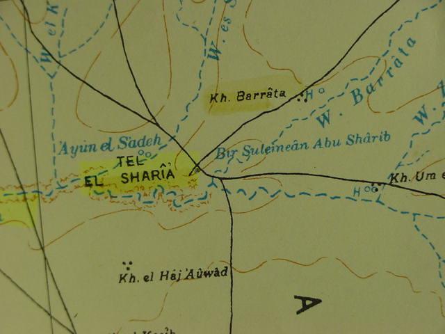
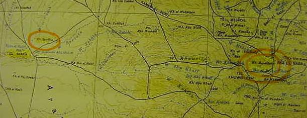
Below, my two proposals for Bered: to the viewer's left: khirbet Barrata (orange oval) on wadi Barrata by Tell es Sharia on Wadi es Sharia (Modern Israeli: Nahal Gerar) and viewer's right: khirbet Bureideh (double orange oval). I, however, prefer Bureideh over Barrata for the siting of Bered.
Could the ascent of Akrabbim be Rugm umm el Kharrubeh NW of Arad?. The border, from the Dead Sea, to Akrabbim, would "turn south of this ascent to Khasim Zanna (Zin, Sina, Senna) and end at Kadesh-barnea (Massah and Meribah? at Meshash, Tell Masos?).
From Kadesh-barnea the border passes to Hazar Addar, perhaps the Iron Age II fort at Ain el Qudierat? Whereas Azmon (Targum: Qesam) is preserved in Wadi Qusaimeh, and its two Iron Age II forts. The river of Egypt being the Wadi el Arish that drains this area. Iron Age II sites dot this area from Meshash to Qusaimeh.
Could Bir es-Sakaty recall the well of Esek associated with Abraham on the below map?
Could Bir Hassan el A'atham be the wilderness of Zin/Sin?