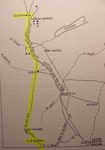
The Darb esh-Sha`ira, biblical "Way of Mt. Seir from Horeb to Kadesh-Barnea." (p.100, fig. 1; Ze`ev Meshel, "The History of Dharb Ghaza- The Ancient Road to Eilat and Southern Sinai." pp.99-117. Ze`ev Meshel. Sinai, Excavations and Studies. Oxford. Archaeopress. 2000. ISBN 1-84171-077-6 pbk. pp.161).
This track passes the foothills of Gebel esh-Sha`ira going north to Kuntillet Ajrud and Quseima (biblical Azmon), Kadesh-Barnea being identified with Ain Qudeirat by Meshel and other scholars. Note that Har Timna, which I have identified as the Prototype underlying the events at Mt. Sinai/Horeb, is east of the Darb esh-Sha`ira and halfway between Yotvata and Elat.
Warning, I NOW understand, as of 26 September 2003, that Kadesh Barnea is NOT Ain el Qudeirat as portrayed on Meshel's below map. I understand that Ain el Qudeirat is Hazar-Addar. I argue that "Seir" is the Judaean Hill Country north of Arad, seized by Edom after 586 BCE. I understand that the Exodus' geography is that of the Exile, 586-562 BCE. Please click on the following blue underlined url titled for all the in-depth argumentation Kadesh Barnea is Tell Masos ?