Dophkha, Alush, Rephadim, Horeb, Sinai (Map of)
Walter Reinhold Warttig Mattfeld y de la Torre, M.A. Ed.
02 Feb. 2004
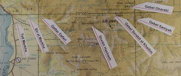
Tell Markha is an Egyptian anchorage site frequented during Dynasties 18-20 and has been excavated by Professor Gregory D. Mumford. Miners were dropped off here and treked inland to the mines of Serabit el Khadim.
Some scholars have suggested that the plain el Markha lies in is the Wilderness of Zin, encountered in route to Mt. Sinai (noting the coastal headline above el Markha -not on this map- is called Ras Abu Zenimeh, perhaps preserving Zin).. I understand that the well of Qattar Dafari may be biblical Dophkah, Alush is Sheikh Hashash, Rephidim is Serabit el Khadim, Gebel Gharabi is the "rock of Horeb" or "Mount Horeb" (Hebrew Choreb?) and Mt. Sinai is possibly Gebel Saniyah. Gharabi and Saniyah lie adjacent to each other and within view of the Egyptian mining temple dedicated to the cow-goddess Hathor (Tor, Egypt. 1:250,000. Sheet NH 36-15. 1972).The eastern foothills of these two mounts face the great plain or drainage basin called Ramlet Himeiyir, below the western slopes of the El Tih mountain chain (Qal'et El-Nakhl, Egypt. 1:250,000. Sheet NH 36-11. 1972). This great plain would be an admirable site for the "millions of Israel" to assemble on (the plain is ten times the size of the plain of Er-Raha below the northern slopes of Ras Safsafa near Gebel Musa, the traditional Mt. Sinai).
I understand that the shattered steliform panels with Proto-Sinaitic inscriptions, which have been found by archaeologists in a shattered state, having separated and fallen from the sides of mountains near Egyptian mining caves of the 12th Dynasty (near Serabit el Khadim), may be what is behind the notion of Moses hurling down the two tables of the Law near the camp at the foot of mountain. The worship of the Golden Calf may be a dim memory of the mining temple dedicated to the Cow-godess, Hathor, patroness of the miners, and in Egyptian myths, the sky which gave birth each morning to the rising sun as a Golden Calf. Late Bronze and Early Iron Age pottery debris exists in this region to connect the Exodus narratives to, many scholars suggesting an Exodus ca. 1446 or 1260 BCE. Perhaps Israel knew of the mining camps of Serabit el Khadim, which were usually abandoned by the onset of Spring by the miners to avoid the sweltering heat in the mines, the Exodus being a Springtime event. After a year at Mount Sinai, Israel headed for the Wilderness of Paran, perhaps the Wadi Feiran and its headwaters, to the ESE of Gebel Saniya (Sinai?)