Map of Ije-Abarim, Iye-Abarim, Iyim, "east of" Moab, NOT "east of" Edom
10 March 2004
Revisions through 24 March 2009
Scholars are not in consensus on Iye-Abarim's location. Part of the confusion, it appears to me, is that many scholars assume _wrongly_ that the "river of Zered" is Wadi el Hesa.
Mattingly noted two sites suggested for Iye-Abarim, Muhai and Medeiyineh. He expresses reservations about Muhai -which is Iron Age- because in his mind it is north of the Zered (Wadi el Hesa) and in scripture it was reached BEFORE the Zered, NOT AFTER.
Mattingly :
"Although no site has been linked to Iye-Abarim with certainty, Nu 21:11-12 points to a location between Oboth and Wadi Zered, and at least two sites in this area have been proposed: (1) Muhai, located 11 miles SE of Mazar, is on the wilderness side of Moab, but it is north of the Zered; and (2) Medeiyineh is on a hilltop that rises out of the Zered canyon and would be more like the place of encampment that followed Iye-abarim. Nu 33:44-45 seems to indicate that this site was in Moabite territory and that its shorter name was Iyim."
(p. 588. Vol. 3. Gerald L. Mattingly. "Iye-Abarim." David Noel Freedman. Editor. The Anchor Bible Dictionary. Doubleday-Anchor. New York. 1992)
Grohman:
"Iye-Abarim [heaps of the regions beyond, or perhaps of the passes]. KJV Ije-Abarim, ije. A stopping place of the Israelites, following Oboth, and preceding the 'Valley of Zered" (Nu 21:11-12; see Zered, Brook) or Dibon-gad (33:44-45). Iye-Abarim was in the wilderness on the SE border of Moab. It is tentatively located by some in the region of Mahaiy, a strong Moabite fortress dominating the ascent from the Brook Zered."
(pp. 775-776. Vol. 2. E. D. Grohman. "Iye-Abarim." George Arthur Butler. Editor. The Interpreter's Dictionary of the Bible. Nashville & New York. Abingdon Press. 1962)
Gold on Wady el Hesa being the Zered:
"Zered, Brook, zir'id. Alternately: Valley of Zered (Nu 21:12); KJV Valley of Zered, zar'id. The stream which the Israelites crossed marking an end to their thirty-eight years of wandering in the wilderness (Nu 21:12; De 2:13-14). It is identified with the Wadi el Hesa, which flows into the the SE end of the Dead Sea...The Zered constituted the N boundary of Edom and the S boundary of Moab."
(p. 954. Vol. 4. V.R. Gold. "Zered, Brook." George Arthur Butler. Editor. The Interpreter's Dictionary of the Bible. Nashville & New York. Abingdon Press. 1962)
I understand that the Zered IS NOT Wadi el Hesa, it is Wadi el Hafire at Qatrane. I agree that Wadi el Hesa IS THE BORDER between Moab and Edom. Edom lies SOUTH of el Hesa and Moab lies NORTH of el Hesa.
Hence, for me, Iye-Abarim cannot be "south" of a Wadi el Hesa/Zered and EAST OF EDOM.
Nu 21:11-12 RSV,
"And they set out from Oboth, and encamped at Iye-Abarim, in the wilderness which is opposite Moab toward the sunrise. From there they set out, and encamped in the valley of Zered.
Nu 21:11-12 Septuaginta (1851 English Translation by Sir Launcelot Brenton),
"And having departed from Oboth, they encamped in Achalgai, on the farther side in the wilderness, which is opposite Moab, toward the east. And thence they departed, and encamped in the valley of Zared."
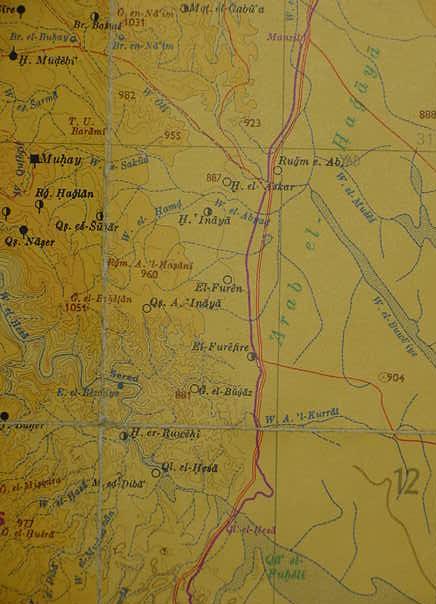
Ije-Abarim, Iye-Abarim, Iyim LXX : Achalgai, Gai, Gaia is probably the plain of Arab el Hagaya, in Green print on the below map (Achalgai being preserved in el-Hagaya), which lies to the north of Wadi el Hesa (Qal`at el Hesa on the map). That is to say, Iye-Abarim has been preserved in Arabic as a toponym based on the Greek Septuaginta's rendering of the name rather than the Hebrew Massoretic text's rendering, perhaps after Byzantine Christians usage?
The doubled Red line is the "Way of the Wilderness to Moab."
Could Tell Umm Baramil (on the below map rendered as T.U. Baramil in brown ink), an "elevation or height" preserve Abarim? Arabic Umm Baramil might preserve Iyim as Umm and Abarim as Baramil? It lies just north of Iron Age Muhay (Muhay as been suggested as a possible location for Iye-Abarim, I think this is plausible) be Iye-Abarim? (cf. Map titled Sud Blatt. 1:300,000. 1979 Ernst Hohne & Hermann Wahle. Palastina Historisch-Archaologische Karte. Gottingen. Vandenhoeck & Ruprecht. 1981. ISBN 3-525-50157-9)