Maps of Some Arab Tribes In Genesis:
Joktan, Son of Eber, and Joktan's "sons": Uzal, Jobab, Havilah, Diklah, & Hazarmaveth
(Genesis 10:25-30)
04 October 2009 (Revisions through 03 January 2010)
Cohen (1962) on Joktan:
"Joktan, jok'tan, ["younger son" (?); cf. Arabic Yaqtan, from "be watchful"]. The younger son of Eber, and the brother of Peleg. His descendants represent a number of Arabian groups (Gen. 10:25-29; I Chr. 1:19-23). These comprise the aboriginal inhabitants of the country, in contrast to the later immigrants, the children of Abraham by Hagar and Keturah. Arabic historians of the Islamic period have tried to identify Joktan with Kahtan, a character of Arab legend, but the consonants are not the same in the Semitic alphabet.
The thirteen peoples enumerated as descendants of Joktan are reported to have lived in the territory which extended from the district of Mesha, in the north part of Arabia, to the mountain of the east, in the south part. The first four names, which include Hazarmaweth (Hadramaut), were evidently located along the coast that faces the Indian ocean; others may have been in Yemen, while the remainder occupied the area further north."
(S. Cohen. "Joktan." pp. 963-964. Vol. 2. George Arthur Buttrick. Editor. The Interpreter's Dictionary of the Bible, An Illustrated Encyclopedia. Nashville & New York. Abingdon Press. 1962)
Hess (1992) on Joktan:
"Joktan (Person) [Hebrew yoqtan]. Son of Eber, brother of Peleg, and father of thirteen descendants, whose settlements ranged from Mesha to Sephar, in the hillcountry to the east (Gen 10:25-30). As a descendant of Shem, Joktan represents that part of the line which, in the Table of Nations, is found in southwest Arabia. There is a possible relationship between the name and a figure remembered as the ancestor of the southern Arabs...Although it is unclear whether Joktan is a prefixed verbal form of the Sabaean root qtn (cf. Ryckmans 1934 1:190; Biell 1982: 452), its meaning "to be small," is associated with this root in West Semitic and appears in geographic names such as Qatna. Its possible appearance here as the last named figure of the Table of Nations to have descendants listed, raises the question of a word play between Joktan and Jepheth, the first named figure in the Table. Jepheth's name is related to the concept of enlarging (pth) in the word play of Genesis 9:27, and is also a prefixed verbal form.
The relationship of Joktan to Jokshan, the son of Abraham and Keturah, in Genesis 25:2,3 is not clear. Despite the fact that both figures have sons named Sheba and Dedan, the equation of the two names is linguistically implausible, and all ancient versions follow the Hebrew in distinguishing the two. Further, since both are geographic names, the different ancestry in the two chapters may reflect distinct peoples among the inhabitants of both Sheba and Dedan.
Bibliography:
Biella, J.C. 1982. Dictionary of Old South Arabic. Sabaean Dialect. HSS 25, Chico, CA.
Ryckmans, G. 1934-35, Les noms propres sud-semitiques. 3 vols. Louvain.
Winnett, F.V. 1970. The Arabian Genealogies in the Book of Genesis. pp. 171-96 in Translating & Understanding the Old Testament. Editors: H.T. Frank & W.L. Reed. Nashville.
(Richard S. Hess. "Joktan." p. 935. Vol. 3. David Noel Freedman. Editor. The Anchor Bible Dictionary. Doubleday. New York. 1992)
Burkhardt (before 1831):
"...the Beni Kahtan, a large tribe; the strongest and most considerable between Ateybe and Hadramaut...The Beni Kahtan are subdivided into two tribes: Es-Sahama...and the tribe of El Aasy...The Kahtan...are exclusively Bedouins. The Kahtan are more rich in camels than any Bedouins of the eastern desert..."
(p. 30 & 46. Vol. 2. John Lewis Burkhardt. Notes on the Bedouins and Wahabys collected during his travels in the east by the late John Lewis Burkhardt. London. Henry Colburn & Richard Bently. Published for the Association for Promoting the Discovery of the Interior of Africa. 1831)
My notes:
Cohen noted that Hebrew Yoqtan did _not_ phonetically match Arabic Kahtan (Qahtan). I note that Hebrew
Yerusalem does _not_ match phonetically Canaanite Urusalim of the Tell Amarna letters addressed to Pharaoh Akhenaten (14th century BC) by the prince of Jerusalem, Abdi Heba/Hepa, warning pharaoh that all the land of Canaan has been lost to the apiru/habiru and that only Urusalim has not yet fallen. This phonetic anomaly suggests for me that for whatever reasons the Hebrews were not loathe to changing earlier forms of words that were not Hebrew: Urusalim became Yerusalem and perhaps Kahtan became Yoktan? The Beni ("sons of") Kahtan/Qahtan still exists today (2009) as a large tribal federation in Saudi Arabia just north of the Yemenite border. The Bible suggests Hazarmaveth (Gen 10:26) is a "son" of Joktan and Hazarmaveth appears in Wadi Hadramawt in the Yemen (not on this map) to the southeast of the Beni Kahtan tribal federation, that is to say, Kahtan and Hazarmaveth/Hadramawt are in "proximity to each other" in southwest Arabia, so, most likely, the Arabic traditions are "correct," Kahtan is the Bible's Joktan and the Hebrews have _changed_ the Arabic pronounciation/spelling just like they changed Canaanite Urusalim into YErusalem.
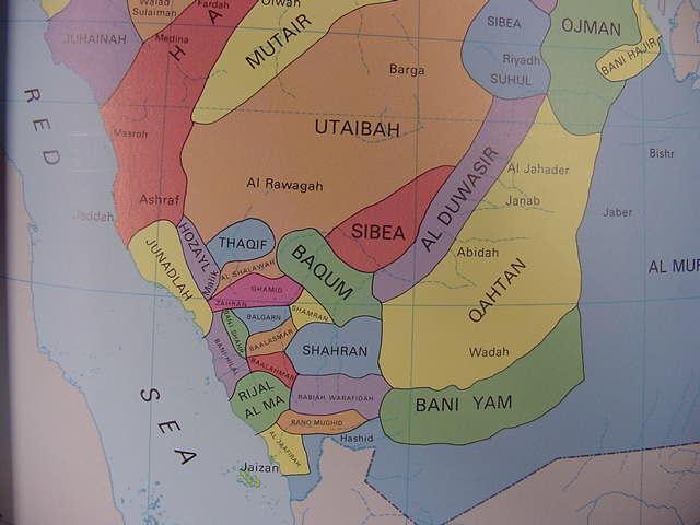
Below, a map (1980) showing the area inhabitated by the Kahtan/Qahtan tribal federation (Map titled: "Tribes." Hussein Hamza Bindagji. Atlas of Saudi Arabia. Oxford, England. Oxford University Press. 1980. Note: this a paperback without any page numbers. There are 72 pages)
Note: Perhaps Burkhardt's Ateybe (1831) is the tribal federation of Utaibah (1980) on the below map, north of the Qahtan?
One of Joktan's sons was Uzal (Genesis 10:27), perhaps the tribe of Hozayl to the southwest of the Utaibah is Uzal?
Sheba (Genesis 10:28) is another "son" of Joktan, could the two tribes of Sibea (in red and blue) north of Qahtan (and Al Duwasir) be Sheba?
The gray area at the bottom of the below map is the Yemen.
Below, a map showing the B. Hobab (Beni Hobab, the "Sons of Hobab"), perhaps (?) Joktan's "son" (Hebrew: "son" being ben) Jobab (Hebrew: Yobab) of Genesis 10:29? (cf. Map dated 1848 by Heinrich Kiepert, titled "Arabien," printed at Weimar, Germany, available on the internet at the David Rumsey Historical Maps Collection). Note: My research into Joktan's "sons" reveals that in many instances the Hebrew "Y" rendered in English Bibles frequently as "J" appears _not_ to be preserved in Arabic. Hebrew Joktan is preserved in Arabic as Kahtan/Qahtan, more specifically as the Beni Kahtan, the "sons of Kahtan/Qahtan." So be aware in your research for the sons of Joktan that the Arabic forms today in some cases may _not_ preserve the "y" of Hebrew or "j" of English renderings. The below map (1848) reveals that the Beni Hobab are located today (2009) in the Saudi Arabian province of Jaizan to the south of the province of Asir. They are very near the Red Sea coast.
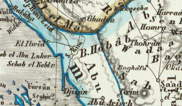
A tribe called Yuhaybab appears in Sabaean inscriptions (3rd century BC) found in the Yemen (cf. W.W. Muller. "Jobab." p. 871. Vol. 3. David Noel Freedman. Ed. The Anchor Bible Dictionary. N.Y. 1992):
"The Sabaean tribe with a similar name (yhybb) was one of the three of tribal federations of the ancient country of Sum'ay in the central highland of Yemen. This tribe or its tribal leaders are mentioned in several inscriptions from the same region..."
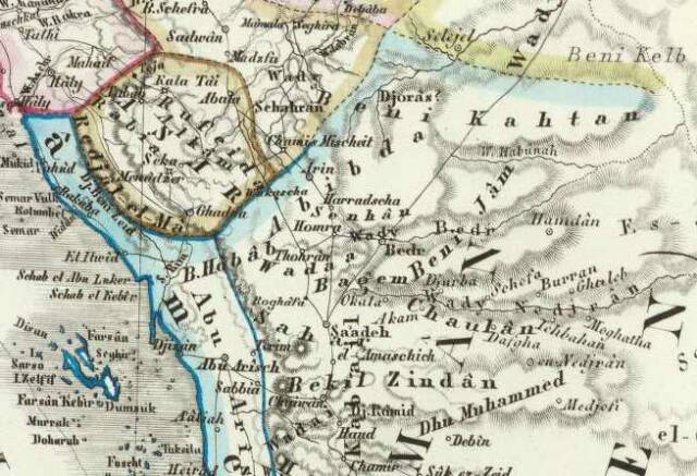
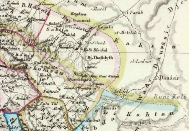
Below, a map showing the Beni Kahtan, the "sons of Kahtan," biblical Joktan (?) to the WNW of the B. Hobab, Beni Hobab. Perhaps this "nearness" in location is "why" the Beni Hobab are portrayed as being a "son" of Joktan? The modern Saudi Arabian province of Asir is N of the Beni Hobab and W of the Beni Kahtan (the below map is dated 1848. Heinrich Keipert. "Arabien," Weimar, Germany, and is available at the David Rumsey Historical Maps Collectionon the internet, a wonderful source, by the way, of maps of the 18th-20th centuries AD!). To the S of the Beni Kahtan and the SE of the Beni Hobab is the Chaulan (Khaulan, Khawlan on other maps), frequently identified as Joktan's "son" Havilah, a brother of Jobab. Perhaps the "proximity" or "nearness" of Kahtan, Hobab and Chaulan is "why" they are "related" to each other as "father and sons"? The Kahtan being the "largest" of the SW Arabian tribal federations perhaps became, because of their size, the "father" of the smaller tribal federations in the SW Arabia area in Jewish eyes?
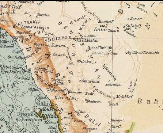
Below, a map (1929) with less detail, showing the Beni Kahtan's huge tribal area to the N of Asir (today in Saudi Arabia). From Jerusalem, via the Great Spice and Incense Route to Sheba and Marib in the Yemen, one passes through the territory of the Beni Kahtan. In the midst of their territory lies Qal'at Bishah on Wadi Bishah. W.W. Muller (1992) has suggested that Wadi Baysh in the Khawlan south of Asir might be the Pishon associated with Genesis' Havilah and that as Wadi Bishah also drains from the Asir that Bishah and Baysh may have been conflated together into the Pishon. I concur. To get to Havilah (Chaulan) from Jerusalem a Jewish trader would most likely cross the Bishah/Pishon at Qal'at Bishah in the midst of the Beni Kahtan's territory, then pass south to Havilah/Chaulan which is watered by Wadi Baish/Baysh which in part rises in the Asir mountain range. So, grouped together in this sector are Joktan (Beni Kahtan), Jobab (Beni Hobab), Havilah (Chaulan), and the "land of Havilah" (Chaulan) with its river the Pishon (Wadies Bishah and Baysh). Of interest is that Wadi Baysh is a perennial river, it has water all year round like the Nile, said feature probably being why it is remarked upon with such honor in Genesis 10:11-12. The mountains it drains from are perhaps where Havilah's gold, bdellium resins from forested slopes and precious shoham stone come from? The below map is dated 1929, made for the Italian Automobile Touring Association at Milan, Italy and is available at the David Rumsey Historical Maps Collection).
The below 1848 map shows _two_ tribal areas for the Beni Kahtan: (1) North of Asir with Qal'at Bishah and Wadi Bishah (the Pishon?) in its midst, through which must pass a Jewish trader from Jerusalem to Sheba in the Yemen, and (2) a second Beni Kahtan just North of the Chaulan (Havilah) which is not on the below maps but can be seen on the above preceding 1848 map.
Diklah (Diqlah), Genesis 10:27, a son of Joktan, "might" be preserved, below, at the village of Dakhla bordering the Hadhramawt Region of the Yemen? I have marked it with an oval in red and pink marker on the below maps (Map published at Milan, Italy in 1929 for the Italian Automobile Club and is available at the David Rumsey Antique Maps Archive and Collection on the internet). Please click here to access an interactive version of the below map allowing you to scroll N-S, E-W, and enlarge or reduce the map.
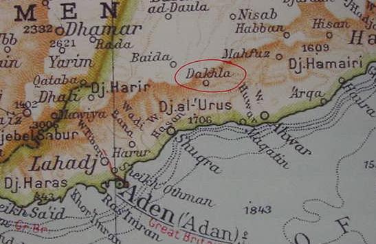
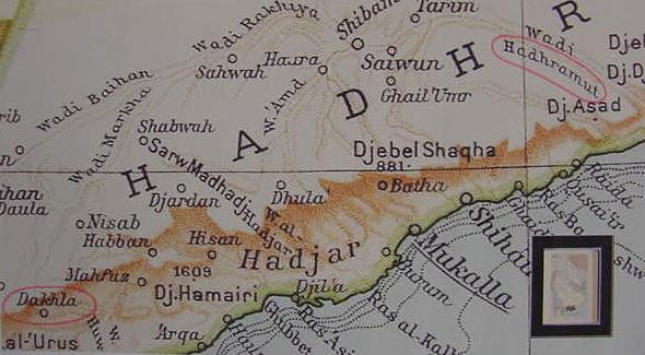
Below, Dakhla (Joktan's son Diklah?) at viewer's lower left in marker oval and Diklah's "brother" Hazarmaveth, preserved at Wadi Hadramaut, viewer's upper right in marker oval (1929 Milan, Italy. Map 91, "Arabia." Touring Club Italiano Atlas).
The below entries culled from the internet for Diklah suggest it could be a "place-name" which was made into a tribal name. If this be so (as for example, Hadhramut, a place, being Hazarmaveth, "son of Joktan"), then Dakhla "might" be _another example_ of a place-name being transformed into a "son of Joktan"? This place is situated in Abyan, Former South Yemen, Yemen, its geographical coordinates are 13° 53' 0" North, 45° 59' 0" East and its original name (with diacritics) is Ad Dakhlah. The Google satellite map shows a village straddling a broad wadi bed, and a cluster of trees (Palms?) in the midst of the wadi bed.
Hebrew
Strong #01853: Diqlah
Diklah = "palm grove"
1) a son of Joktan of Arabia
2) an Arabian territory or people?
1853 Diqlah dik-law'
of foreign origin; Diklah, a region of Arabia:-Diklah.
DIKLAH, son of Joktan, and name of a district inhabited by his descendants, Gen. 10:27.
DIKLAH [SMITH]
(palm grove). (Genesis 10:27; Chronicles 1:21) a son of Joktan, whose settlements, in common with those of the other sons of Joktan, must be looked for in Arabia. It is thought that Diklah is a part of Arabia containing many palm trees.
DIKLAH [ISBE]
DIKLAH - dik'-la (diqlah, "place of palms"): One of the "sons" of Joktan (Gen 10:27; 1 Ch 1:21). Perhaps a south-Arabian tribal or place-name connected with a palm-bearing district.
I have _not_ consulted the following work which would probably be very useful to anyone seeking to identify biblical Joktan and his sons:
Richard Trench. Gazetteer of Arabian Tribes. 18 Volumes. Cambridge Archives Series. Cambridge, United Kingdom. 1996. With 6 maps showing various tribes and clans. It sells for 5,000 British Pounds Sterling (USA $10,000.00).
Book Description: Archive Editions Ltd (Cambridge University Press), 1996. Hardback. Book Condition: Brand New Hardback. 17.64 by 17.6 inches. (12,000 pages). A collection of historical descriptions of Arabian tribes from British archival sources in the 19th and 20th centuries.The Gazetteer provides a magnificent collection of historical descriptions of Arabian tribes from British archival sources in the 19th and 20th centuries. Some 745 tribes are included, representing most of the major clans and families in the Arabian peninsula. From Iraq and Syria the geographic coverage includes Jordan, Saudi Arabia and the Gulf States to Oman, the Hadhramaut and Yemen. The records show territories and nomadic routes, tribal relations and allegiance, military strength, personalities and modern influence. These volumes provide the broadest array ever assembled of English language historical references concerning approximately 745 tribes, tribal confederations and clans in the Arabian peninsula. It is likely to remain the definitive research work for tribal history. From the eyewitness accounts of the Hijaz tribes riding into battle in 1917 to a social and political breakdown of the Jaburi tribe of Iraq, this gazetteer is an important resource to the study of Arab history.