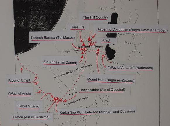
The Exodus Setting of 562 BCE and the Late Iron II border of Judah
The Exilic narrator of ca. 562 BCE has projected sites of his world to his mistaken notion of a 1446 BCE Exodus (The Conquest as attested by Archaeology is Early Iron Age IA, 1220-1150 BCE). Why ? So that his Exilic audience can relate to sites they are familiar with, in existence since 640 BCE. Edom's "south border" that Kadesh Barnea is "in" I understand to be Wadi Beersheba. I identify Tel Masos with Kadesh Barnea. It is THE EARLIEST AND BIGGEST IRON IA SITE IN THE NEGEV. This map is intended to accompany the text in my article titled "Kadesh Barnea is Tel Masos ?" CF. that article for all the details and arguments.
The Red dotted line marks the border of Judah in Iron II, according to my research. I understand that Ain el Qudeirat is NOT Kadesh Barnea, its biblical Hazar-Addar (Nu 34:4). Qudeirat HAS NO IRON IA DEBRIS ANYWHERE, the same holds for Ain el Qadeis- NO IRON IA debris.
The below map is "an adaptation" of a map in Amihai Mazar's "Map of Geographic Regions in Palestine" (cf. p. 5. Amihai Mazar. Archaeology of the Land of the Bible, 10,000-586 BCE. New York. Doubleday. 1990)