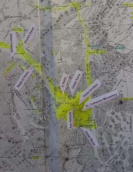
Map of Kibroth-hatta`avah
Walter Reinhold Warttig Mattfeld y de la Torre, M. A. Ed.
The below map shows what I believe to be the location of Kibroth-hatta`avah according to the Christian guides or monks, escorting the Pilgrimess Egeria, ca. the 4th/5th century CE. Egeria stated that the site was located at the entry to a great valley extending some 16 Roman miles in length and opening to 4 miles in width. She stated that from the entry point the "Mountain of God" could be seen in the distance. Later she mentions this site again upon her "return to Pharan" (the modern Feiran Oasis, WNW of this great valley, biblical Paran ?). The yellow highlighting shows the southern end of this great valley ending in the plain of el Raha, below the northern slopes of Ras Safsafa. Gebel Musa lies further south and is NOT viewable from the plain. On the north side of el Raha lies Gebel Suna, whose name appears similar to Mt. Sinai. Gebel Arribeh lies adjacent to and east of St. Catherines' and suggests Mt. Horeb. Egeria stated that her guides informed her that the stone circles in the valley were huts made by Moses' Israelites. Archaeologists have determined they were constructed in the Early Bronze II (ca. 2400 BCE) by copper miners from Arad and the Negev. A major EBII site is at Sheik Awad, which I identify with Egeria's Kibroth-hatta`avah as it lies at the entrance to the great valley. To the west of the entrance lies Gebel Haweiti, and south of the entrance is Naqb Hawa, "Pass of the Wind." In scripture God causes a wind to bring down quail upon his people at Kibroth-hatta`avah. Perhaps Haweiti preserves Hatta and Awad or Hawa preserve Hebrew "avah" ? Paran/Feiran lies WNW of Sheikh Awad, which lies in the southern periphery of the great drainage basin of Wadi Feiran. Perhaps Israel's breaking camp at Sinai (Gebel Saniya near Serabit el Khadim ?) and heading for the wilderness of Paran, recalls Wadi Feiran and its drainage basin ? (cf. Feiran sheet 8, Gebel Katharina, sheet 9, 1:100,000. 1937 Survey of Egypt. Southern Sinai)
Note: Many scholars understand Mt. Sinai to be Gebel Musa. The Problem ? Despite repeated archeological surveys of the area NO Late Bronze Age (ca. 1580-1200 BCE) or Early Iron I (ca. 1200-1000 BCE) evidence has been found of Israel's encampments, most scholars dating the Exodus to either 1446 BCE or ca. 1260-1175 BCE. The ONLY encampments are those of the Chalcolithic or Stone Age and Early Bronze II eras, the 5th-3rd millenniums BCE. Evidently these sites were misidentified by Egeria's Christian monk guides as Israel's "huts."