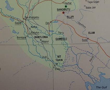
Below, a map showing Elam and Bit Yakin (Bit Iakin). Bit Yakin lies near Ur and Eridu and West of the sea-lands or tam-tu, marked by a dotted line, which some scholars understand was the head of the Persian Gulf in antiquity. Other scholars disagree that the Gulf was ever this far north. About 2000 BCE the Persian Gulf dopped in sea level by one meter (three feet) as revealed by excavations and probes on the island of Failaka near the mouth of the Shat al-Arab (cf. p. 267. D. T. Potts. The Arabian Gulf in Antiquity. Vol. 1 [2 Vols.].. Oxford. The Clarendon Press. 1990 ) (For the below map cf. p. 179. "The Assyrian Empire in the 8th Century BC." Michael Roaf. Cultural Atlas of Mesopotamia and the Ancient Near East. New York. Facts on File. 1990)
Modern Arab traditions locate the Garden of Eden that Dilmun at Qurnah, where the Euphrates and Tigris rivers meet to form the Shatt al-Arab, which debouches into the Gulf.