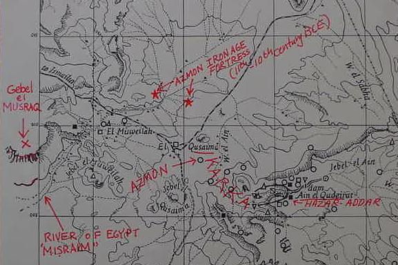
Proposals for Judah's southernmost border. I understand that Hazar-Addar is the Iron Age II Fortress at Ain el Qudeirat as noted by the famous American Bible scholar, George Ernest Wright back in 1956, he identifying Kadesh Barnea with Ain el Qadeis (cf. p. 68. George Ernest Wright. The Westminster Historical Atlas to the Bible. 1956. Philadelphia. Westminster Press). I understand that Karka is the "ground floor or plain" (in Hebrew Karka means "ground floor") WSW of Ain el Qudeirat, at the mouth of Wadi el Ain, this plain extending to Ain el Qusaima (Azmon). Two Iron Age fortresses (ca. 11th-10th century BCE, RED STARS) control the plain to the north of Ain el Qusaima. The "river of Egypt," Hebrew Misraim, is Wadi Muweilah, which drains the plain about Azmon/Qusaima, and, passing the southern slopes of Gebel el Musraq, turns north to become a single stream, the Wadi el Arish which meets the Mediterranean Sea. I understand that the "river of Misraim" (Wadi el Arish,) takes its name from headwaters draining the vicinity of Azmon/Qusaima, this name, "Misraim" is derived from Gebel el Musraq. So the "river of Egypt," (wadi Muweilah and Wadi el Arish), takes its name from headwaters about Gebel el Musraq draining from Qusaima/Azmon.
Joshua 15:1-4 RSV
"The lot for the tribe of the people of Judah according to their families reached southward to the boundary of Edom, to the wilderness of Zin at the farthest south. And their south boundary ran from the end of the Salt Sea, from the bay that faces southward. it goes out southward of the ascent of Akrabbim, passes along to Zin, and goes up south of Kadesh-Barnea, along by Hezron, up to Addar, turns about to Karka, passes along to Azmon, goes out by the brook of Egypt, and comes to its end at the sea."
(Note: a number of scolars believe that Hezron is an error for Hazar-Addar in a parallel verse, Numbers 34:4)
For the above map, cf. p. 34. "Archaeological Survey Map of Kadesh-barnea." Beno Rothenberg, et al. God's Wilderness, Discoveries in Sinai. New York. Thomas Nelson & Sons. 1961). The "red lettering" is my own, for Hazar-Addar, Karka, Azmon, the river of Egypt, and Gebel el Musraq.