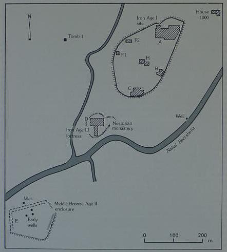
Tel Masos Map. The Iron Age I site, late 13th-11th century BCE, embracing 15 acres (the largest ever Iron I site in the Negev) is in the upper right quadrant. The Iron Age III 7th century BCE Fortress is probably the Kadesh "in existence" at the Fall of Judah in 586 BCE. The Iron I city which began as a late 13th century TENT ENCAMPMENT is probably Moses' Kadesh Barnea of the Wilderness Traditions. Note the site is in the midst of Wadi Beersheba, which I have identified as Edom's Exilic border, 586-562 BCE, understanding that the Exodus narratives were composed ca. 562-560 BCE in the Exile, the narrator presenting his Exilic audience the Exodus in an Exilic setting so that that could relate to it and comprehend it (He evidently mistakenly thought it occured ca.1446 BCE [cf. 1 Kings 6:1], but it is evidently a late 13th century BCE Ramesside event). Note also the 5 wells in the area, proably "the Watersof Meribah Kadesh."
(For the Map cf. p. 986. Vol.3. Aharon Kempinski. "Masos, Tel." Ephraim Stern, Editor. The New Encylopedia of Archaeological Excavations in the Holy Land. New York. Simon & Schuster. 1993)