Please click here for another article on the Nar Marratum Map arguing that the Bitter River is not a Cosmic Ocean but instead the Tigris and Euphrates rivers encircling Babylonia, the word Marratum being preserved in the Shatt al Amarah (a part of the Tigris River above Qurnah and east of Babylon).
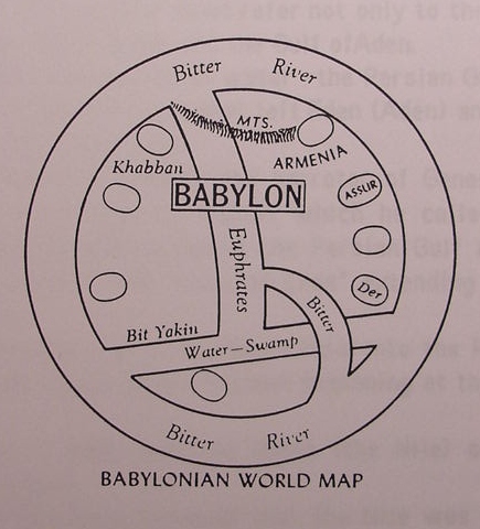
This drawing is by Kraeling rendering the Nar (river) Marratum (bitter) as the "Bitter River" its generally being understood to represent a "Cosmic Oceanic River" encircling the world embracing the Persian Gulf, Caspian, Black and Mediterranean Seas (p. 43. Emil G. Kraeling. Rand McNally Bible Atlas. New York. Rand McNally & Company. 1966)
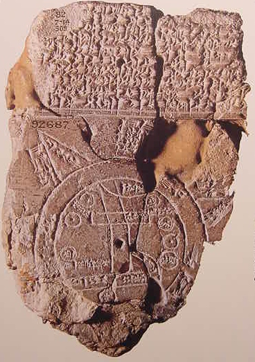
Below, a photo of Clay Tablet showing Map of the World, encircled by the Nar Marratum or "Bitter River", i.e the salty Ocean, which appears in the above diagrams rendered into English place names (p.125, Micheal Roaf. Cultural Atlas of Mesopotamia and the Ancient Near East. Oxford & New York. Facts on File. ISBN 0-8160-2218-6 1990).
Professor Samuel Noah Kramer, a distinguished Sumerologist (Emphasis mine) :
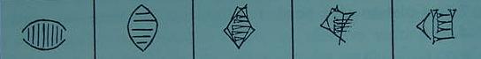
"The cuneiform system of writing was probably originated by the Sumerians...The cuneiform script began as pictographic writing. Each sign was a picture of one or more concrete objects and represented a word whose meaning was identical with, or closely related to, the object pictured...No. 2 represents the word ki, "earth." It is obviously intended to be a picture of the earth, although the interpretation of the sign is still uncertain." (p. 302. "The Origin and Development of the Cuneiform System of Writing." Samuel Noah Kramer. The Sumerians, Their History, Culture, and Character. Chicago. The University of Chicago Press. 1963. ISBN 0-226-45238-7 pbk)
Although Kramer states that the sign is probably a picture of the earth, he does acknowledge that there is not universal agreement on the symbols being employed. _I "suspect"_ that the two arcing lines juxtaposed opposite each other, represent the Tigris and Euphrates rivers. The verticle lines, are, for me, numerous irrigation canals feeding off these two rivers. I thus understand that this is a highly schematized "map" of the Sumerian's world, _their world_ being the "land between the rivers" (Greek: Mesopotamia). Kramer's three other Ki signs are rendered as Cuneiform wedge shapes from a stylus and do not bear much resemblance to the original first two "pictographic" symbols or signs.
I would furthermore suggest that Genesis' notion (whose composition I date to ca. 562-560 BC) of a world embraced by four great world encompassing rivers, the Hiddekel (Tigris) and Euphrates in the East and the Gihon and Pishon in the West (?) is possibly a Hebrew reformatting of the ancient Sumerian concept of their world being embraced by two mighty river systems. The Hasmonean Jews understood that the Gihon was the Nile according to The Book of Jubilees, believed to have been composed ca. 100 BC. The Jewish Targums understood that the Pishon was a tributary of the Gihon, which was equated with the Nile. The Jewish historian Flavius Josephus understood that the river of Eden encircled the world, perhaps as the Homeric Greek Freshwater "River Ocean or Okeanos" (?) and from it branched the four rivers of paradise; the Gihon was the Nile and the Pishon the Indus. Perhaps the Babylonian notion of their world being surrounded by a river recalls the "second" Sumerian pictographic symbol, shown in Kramer's above chart of the evolution of the world Ki, meaning "earth"? Could the Babylonian concept lie behind Homer's River Okeanus and Josephus' River of Eden?
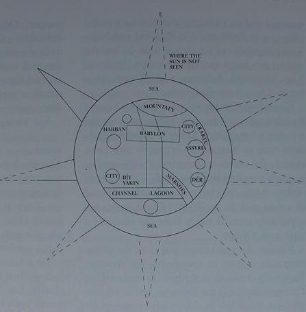
Below, a drawing of the same map showing it "restored" by the artist (cf. p. 53. fig. 46. "Cosmology." Jeremy Black & Anthony Green. Gods, Demons and Symbols of Ancient Mesopotamia, An Illustrated Dictionary. London. British Museum Press. 1992)