Qantara (Kantara) Stone Bridge and Qantara Land Isthmus,
Its Strategic Importance from the Days of the Pharaohs
And musings on the correct siting of the ancient Egyptian fortress of
Tjaru, Tharu, Zaru, Tjel, Zalu; Roman Sile, Selle, Sele, and,
the Qantara Isthmus Possibly being the location of biblical Pi-Ha-Hiroth, the Red Sea Crossing Site.
10 July 2010 (Revisions through 15 December 2019)
Brill's description (1913-1936) of Kantara (Qantara):
"Kantara, plural Kanatir, means in Arabic (1) bridge, particularly a bridge of masonry or stone; also (2) aqueduct (especially in the plural), dam, and finally (3) high building, castle...The original meaning of the word "arch", is found in the earliest Arabic lexicographers...Djisr, a bridge of wood or boats, is the opposite of kantara, which is of stone; in time, however, the two words came to be used as synonyms...No satisfactory explanation has yet been given of the origin of the word...we may with considerable certainity regard it as a loan-word...borrowed from Latin or Greek...Latin...cintrum (French cintre, arch, vault)...Aramaic...ketara= bond, arch...djisr also comes from the Aramaic...3. A small town with a mosque in Egypt, on the Asiatic side of the Suez canal, half-way between Port Sa'id and Isma'iliya, a station on the railway connecting these two towns. It lies on a low narrow tongue of rising ground, which runs out between the large Menzaleh lake in the north and the little Balah lake in the south. But it hardly takes its name from the "land bridge", but from a bridge which already existed here probably in the early Middle Ages.
The Arab geographer Ibn Fadl Allah al-'Umari who wrote about 741 (1340) mentions the arch of a bridge, called Kantarat al-Djisr, near the old caravan station of al-'Akula, under which the superfluous water flowed into the desert at the time of the Nile's inundation. There was still a bridge here at the beginning of the nineteenth century, built over a canal connecting the two lakes already mentioned. The modern al-Kantara has only arisen on its present site since the making of the Suez Canal. The old settlement was a short half-hour's journey to the east and is marked by the mound of ruins Tell Abu Sefe (on the maps called Tell al-Ahmar). This place may be regarded as the key to Egypt, for it has always been used by conquerors as the gateway to the Nile valley. Its strategical importance led to its being occupied in remote antiquity. Tell Abu Sefe (with ruins of a temple of Rameses II and remains of the Ptolemaic and Roman period) marks the site of the ancient Egyptian town of Zaru (T'rw), the capital of the fourteenth district of Lower Egypt, which was a fortress in the time of the Middle Kingdom. In the later Classical and Byzantine literature it appears as Sile, Sele (Selle); according to a Latin inscription found here, it had a Roman garrison in 288 and was later the see of a bishop. In the Middle Ages it was called al-'Akula= "the bend" see above s.v. Dair al-'Akul.), a name which was temporarily supplanted by the castle of al-Kusair during the Mamluk period. In World War (1914-1918) al-Kantara played an important part in the struggle for the Suez Canal...In remote antiquity as well as in the Middle Ages and modern times, al-Kantara was the point of departure for the caravan road from Egypt to Syria."
(p. 722-723. Vol. 4. "Kantara." Martin Theodor Houtsma, editor. Encyclopaedia of Islam. E. J. Brill Publisher. The Netherlands. 1913-1936)
Note: More recent excavations at Tell Abu Sefeh, north east of Kantara reveal it is of the Persian period at the earliest, no New Kingdom Egyptian pottery being found. It existed in Ptolemaic and Roman times as well.
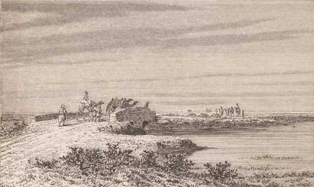
Below, a drawing (1911) showing the stone bridge or Kantara (Qantara) over the "canal" linking the lakes of Menzaleh and Ballah (Balah), with tufts of reeds or marsh grasses in it. Camels (viewer's left) are leaving Egypt, while camels (viewer's right) are approaching Egypt (p. 189. Rev. Samuel Manning. LL.D. The Land of the Pharaohs. Egypt and Sinai: Illustrated by Pen and Pencil. The Religious Tract Society. London. 1911).
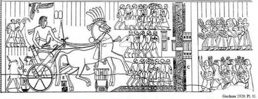
Below, a relief of Seti I (13th century BC) showing a bridge over a canal (?) or waterway (?) with crocodiles in it, lined with rushes and it has two forts before its eastern approach, maybe the two ruins on the Napoleonic map? The bas-relief shows a "sharp right-angle" for the waterway below the feet of the captives herded before Pharaoh's chariot. Brill noted in the Middle Ages Qantara was also called al-'Akula= "the bend" could this "right-angle" be "the bend"? On the above map this waterway's "right-angle-bend" seems to be to _east_ of the Qantara bridge (the Lake Ballah side) while the below relief suggests this "right-angle-bend" would be west of the bridge. On a closer look, I note a _small_ "right-angle-bend" to the west of the Qantara bridge on the Napoleonic map. Is this the western right-angle-bend of the Ta Denit waterway or canal?
Maps of the 1800s before the Suez Canal of 1869 show that Lake Bala (Ballah) received its water from the annual Nile inundations via Bahr ("Sea") Menzaleh. This suggests that Birket ("lake") Bala/Ballah may, at times, have dried up or become a stagnant marsh between the Nile's inundations. In other words Ballah was a "disappearing" sea (bahr in Arabic means "sea" and is applied to canals and lakes as well as the Gulf of Suez and Aqabah; Hebrew Yam means sea and is applied to lakes like the "Sea" of Galilee and Dead "Sea," so the "sea" Israel crossed could have been a "lake"). If a gale force east wind could, in January of 1882, remove lake Menzaleh's waters exposing its lake bottom (4-5 feet deep?) for 7 miles, it probably could do the same at Ballah too, whose waters may have been even shallower (2-4 feet?). Thus Israel's crossing of a dried up Yam Suph (Reed Sea? after an Egyptian iuma=sea, tsuf= reed) became recast as Israel crossing a Red Sea dried up by an east wind? Caravans from Syria and Israel or Judah would hear stories from the Qantara locals of an east wind drying up the iuma tsuf (lake Menzaleh and Bala?) and pass the story on to the Jews in Jerusalem?
.
As regards the crocodiles in the above Ta Denit waterway, be it a channel or canal, Professor Hoffmeir noted (1999) that remains of a crocodile were found near a stone-lined quay at Tell Abu Sefeh (NE of Qantara) which is associated with the northeastern edge of Ballah lakes. So, crocodiles could have wandered into lake Ballah with the Nile's annual inundations along with reeds and marsh grass seedlings.
"...Tell Abu Sefeh...Spring of 1994, full-scale excavations began...A massive Roman-period fort with a nearby harbor complete with stone quays, has been excavated. By one of the quays, crocodile remains were found. Tell Abu Sefeh apparently was situated by one of the northeastern extensions of the el Ballah lakes...But no remains dating to the New Kingdom have been uncovered, indicating that the Ramesside blocks discovered on the surface of the site nearly a century ago were probably brought to the site at a later date."
(p. 183. James K. Hoffmeier. Israel in Egypt: The Evidence for the Authenticity of the Exodus Tradition. Oxford University Press.1999)
The problem as I see it?
Scholars understand that ancient Egyptian T3-rw or Tjaru equates to Calssical Selle, Sele, Sile, a Roman fort of the 4th century AD (cf. the Notitia Dignitatum, a list of Roman military sites). Note: alae meaning "wing" refers to cavalry, Rhinocorura is today el Arish in the Sinai, east of Qantara.
"...alae at Thaubastis, Tacasiria, Scenae Mandrae, Selle, Rhinocorura, Scenae extra Gerras..."
I note that Salhieh was the end of the great caravan route from Syria to the Egyptian Delta throughout the Middle Ages. It makes "sense" to me that a 4th century AD Roman military site like Sile would be preserved into Romano-Byzantine times as Selle/Sele to become under the Arab rule of the 7th century AD Salhieh!
Salhieh is the eastern end of the Delta, beyond it is desert and the bridge at Kantara (Qantara). I wonder, have any excavations ever been done at Salhieh to establish if a Romano-Byzantine fort exists at this location and possibly an earlier Pharaonic fort of the Ramessides (13th century BC)?
It would be "easier" to assemble supplies, soldiers, and chariots at Salhieh which has ready access to fresh drinking water of the Nile and plenty of food stores from nearby farms irrigated by canals than to assemble all these provisions for an army at far-off Hebua (Professor Hoffmeier's proposal for T3-ru or Sele/Selle), east of Kantara.
Hoffmeier understands that T3-rw (Djaru) appears on the Seti I relief as being on the viewer's right side (the west side of the T3-dnit canal or Channel). If T3-rw is Classical Romano-Byzantine Selle and if this site is Salhieh at the edge of the Delta then everyone is looking in the "wrong place" for T3-ru/Zaru/Sele.
Yet, Hoffmeier describes Tell Abu Sefeh as a major Roman fort with docks (quays) so could this be Classical Sele?
I admit to being confused as to "where" T3 denit and T3-ru are located!
A description (1907) of Salhieh mentions "mounds" in the area, could they have an Egyptian or Roman fort under them?
"Salhieh, again, and Korain...big palm-groves at the end of all things on the border of the desert. At Salhieh one walks straight away from civilization and the railway station on to the sand. Only the line of telegraph posts to Kantarah breaks the mnotony. The yellow sand gleams, and the distant mounds here and there fade and seem to take strange shapes in the mirage of sunlight...In the distance, perhaps, camels, laden with a miscellaneous assortment of wares- returning from Syria; for Salhieh is on the old overland route to Asia used since the time of the pharaohs by just such caravans as one may see today...Salhieh is the end of all things, a palm-grove bounded by desert whence one can see almost to Kantarah and the Suez Canal."
(p. 121. Augustus O. Lambough. Egypt and How to See It, 1907-1908. New York. Doubleday, Page & Co., London. Ballantyne & Co. Ltd. 1908)
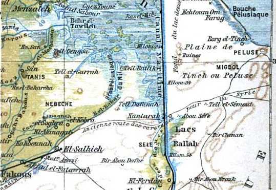
Below, a map (1902) showing el Salhieh at the end of the ancient caravan route from Egypt to Syria labeled in French as "Ancienne route des caravanes pour la Syrie" Abu Sefe is just east of Kantara on the below map where a Roman fort was found (Baedeker's Egypt: A Handbook for Travelers. New York. 1902)
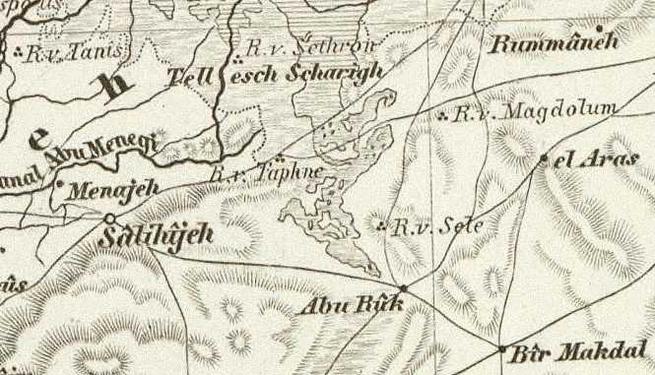
Below, a map (1853) showing two caravan routes coming from Syria to Egypt terminating at Salihijeh. The northern route is via Kantara (not shown) and R.v. Magdolum (another scholarly "guess"), the southern route passing the southside of Lake Ballah (map tilted: Die Nillander. [German: "The Nile Lands"].1853. The Weimar Geographical Institute. Weimer, Germany). Note: R. v. Sele "Ruines von Sele" is the Cartographer's _guess_ as to where ancient Sele/Selle might be located.
The problem wih Salhieh being Tjaru is that appears to be _too close_ to Egypt's border to effectively stop an invasion, the invaders could just circumvent or go around the site.
If an Egyptian fort is to be sought for guarding the approach into Egypt it "might" be better sited at Hebua I, Hoffmeier's proposal for Tjaru. The problem? Where is the canal and fortified bridge of Ta Denit that should lie behind it according to Seti I's bas-relief?
I have another proposal for Tjaru's location, perhaps archaeologists have not yet located it because they are looking in the wrong place?
How so?
The Seti relief shows him herding captives before his chariot which approaches either a canal or waterway on whose west side are Egyptians acclaiming his victories.
If this waterway is the Eastern Canal then Tjaru ought to lie on the east side of this canal and a bridge should be here with guarded portals as portrayed on the relief.
The question to be asked for the correct siting Tjaru should be:
"Where does the caravan track between Egypt and Syria cross the Eastern Canal?
The canal would act as a barrier for caravans and wheeled vehicles (Chariots and Ox-drawn baggage carts).
This caravan track from Egypt to Syria wherever it crosses the Eastern Canal ought to be where Tjaru lies.
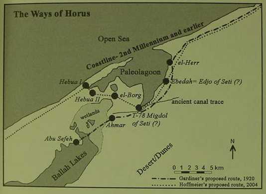
Hoffmeier (2006) understands that Sneh's canal trace (east of Tell Abu Sefeh) as revealed in satellite photos (1990s) does not make a sharp left turn toward Pelusium, it continues on further east by another 4 kilometers, where it becomes lost in sand dunes near an oasis. He now rejects this canal trace as being the Ta Denit and understands that the body of water between Hebua I and II is the Ta Denit (ta d*nit).
"Hebua is situated approximately 9 km north of Tell Abu Sefeh, while the canal trace runs on an east-west line 4 km south of Hebua I (figs. 1, 2). Consequently, associating the canal trace as t* dnit would only make sense if Tell Abu Sefeh were Tjaru, which was the assumption of the Israeli geologists who followed Gardiner's identification. It now appears that the canal trace cannot be t* dnit of the Seti relief. The actual writing of Fortress of Tjaru (htm n t*rw) on the scene occurs on the building on the left side of the water, with another building complex on the right side of a bridge or dike. This nicely fits the sequence of the sites of Hebua II, then the t* dnit waterway, followed by Hebua I (fig. 2). The Seti I relief, it must be recalled, shows the sites in a line moving east to west. It seems quite logical for the name of the site to appear on the east side (left side of relief ) at the entrance of the settlement.13 (See further clarification on this below.) In the light of this new evidence...It has been suggested by the Italian geomorphologist Bruno Marcolongo (1992) that a branch of the Nile passed between Hebua I and II, where it then turned north toward the Mediterranean. This reconstruction has been accepted by Manfred Bietak (1997: 2). We are not convinced that it crossed the barrier island just east of Hebua whence it debouched into the Mediterranean. This interpretation of the Seti I relief was first proposed elsewhere (Hoffmeier and Abd el-Maksoud 2003: 195-97). [the] covered canal trace cannot be t* dnit of the Seti I relief. In view of the fact that Hebua I and II are separated by water, and the Karnak relief shows Tjaru/Sile divided by a water channel called t* dnit, Gardiner's translation of 85 years, "the dividing waters" (Gardiner 1920: 104), may be correct. Could it be the waterway that divided Tjaru/Sile?"
James K. Hoffmeier. "The Walls of the Ruler" in Egyptian Literature and the Archaeological Record: Investigating Egypt's Eastern Frontier." The Bulletin of American School of Oriental Research. August. 2006)
Below, Hoffmeier's map showing Hebua I and II near a paleolagoon. Compare this map with the next map by Bietak showing a branch of the Nile passing between Hebua I and Hebua II. Hoffmeier suggetys that between these two sites is the trace of a Nile channel as noted by Marcolongo in 1992 and accepted by Bietak upon whos map it appears (below).
Professor Maspero (1890s) rendered Professor Hoffmeier's (2005) Tjaru as Zalu, and speaks of it as being a town with a bridge, and the area being subject to Nile flooding, particulars suitable to Salhieh's location:
"...Seti...His entry into Egypt...nobles, priests, and princes of both south and north hastened to meet him at the bridge of Zalu, and welcomed with their chants, both the king and the troops of captives whom he was bringing back..."
( vol 5. Gaston Maspero, et al. History of Egypt, haldea, Syria, Babylonia and Assyria. London. Grollier Society)
"...it was to Zalu they returned triumphant after the campain and there, at the gates of the town, they were welcomed by the magnates of the kingdom. The road ran for some distance over a region which was covered by the inundation of the Nile during six months of the year; it then turned eastward, and for some distance skirted the sea-shore..."
(p.123. "The Military Route from Zalu to Gaza." Gaston Maspero et al. The Struggle of the Nations: Egypt, Syria, Assyria. 1896)
Professor Mumford (2001) understands Tell Heboua might be Tjaru and Tell Abu Sefah Roman Sile:
"More than one hundred and fifty New Kingdom sites are between el-Qantara and Raphia in northern Sinai and numerous sites in northeastern Sinai form ten clusters, with a central fortress or administrative structure, a reservoir, magazines, and satellite campsites. Three New Kingdom sites at Tell Heboua (I-III) straddle a causeway between the western and eastern lagoons (probably t3 dnit: 'the dividing waters'), possibly representing Tjaru (erroneously equated with Tell Abu Sefah, the Romans' Sile). The 'eastern' canal may also be dated to this period."
(p. 290. Vol. 3. Gary D. Mumford. "Sinai." Donald B. Redford. Editor. The Oxford Encyclopedia of Ancient Egypt. Oxford University Press. 3 volumes. 2001)
Block (2008) seems to be in agreement with Hoffmeier, Sile as a site name "moved" from Hebua to Abu Sefeh:
"Apparently the name Sile, located at Tell Hebua from the Middle Kingdom through New Kingdoms, was...transferred to the site of Tell Abu Sefeh, with which it was associated in the Persian through Roman periods."
(p. 128. Daniel I. Block. Israel: Ancient Kingdom or Late Invention? Nashville. B & H Publishing Group [Broadman & Holman]. 2008)
"All the excavated sites in North Sinai that have produced New Kingdom period remains (e.g. Hebua, Borg, Bir el-Abd, and Haruba) were apparently abandoned at the end of the New Kingdom; they have yielded no evidence of later periods. However, Haruba I does haev a 7th century fort."
(p. 128. Note 154. Block)
This article on Qantara's stone bridge has "morphed" into a search for the Rameside fortress of Tjaru (alternately rendered Tharu, Zaru, Zalu, Tjel [Ancient Egyptian had no L, instead it used R) and its bridge, allegedly preserved in Roman era Selle, Sele or Sile.
Several proposals have been:
(1) Hoffmeier's Tell Hebua I which has a New Kingdom occupation (1996). Regarding Hebua Hoffmeier notes:
"Abd el-Maksoud is now convinced that this site is the New Kingdom frontier town of Tjaru...It had a major functioning military installation during the New Kingdom, the period in which Tjaru is often mentioned as the launching point for military campaigns into the Levant. Second, no other site thought to be Tjaru in northwest Sinai has produced any evidence of New Kingdom occupation."
(p. 185. James K. Hoffmeier. Israel in Egypt, The Evidence for the Authenticity of the Exodus Tradition. Oxford University Press. 1996)
My three proposals (2010):
(1) Qantara, (2) Salhieh, or (3) an yet unknown site where the caravan route from Syria to Egypt crossed the Eastern Canal, if this canal is Seti's Ta Denit.
It is interesting to note on my proposal (3) that the Eastern Canal ends at Qalaat et-Tineh where it intersects the Pelusium channel. Is Arabic et-Tineh a corruption of the ancient Egyptian Ta-Denit? At the Pelusium juncture the canal's waters would make a sharp right-angle as appears on the Seti relief below the feet of his captives. Is this the Seti relief's sharp-right-angle, the juncture of the Eastern Canal and Pelusiaic Channel east of et-Tineh?
However, for "ease" of provisioning an army and fort, my proposal (2) Salhieh is a serious contender as it controls the main caravan route from Syria to Egypt. Its three mounds (?) south of the 1799 Arab fort may be the remains of Tjaru/Tharu/Zaru/Saru of the Pharaohs and of the Sile of the Romans. Finally, Sile, Sele, Selle may have passed into Arabic to be corrupted into Salhieh.
Hoffmeier cites Muller on Tharu (Tjaru, Sile) being a town of the eastern delta frontier controlling the mercantile roads to the east (Syria), this description seems to fit Salhieh which is at the very edge of the eastern delta and it does control the mercantile Syria-Egypt caravan route:
"Over a century ago, Max Muller recognized the importance of Tjaru in ancient Egypt...he declared that "no town of the eastern delta frontier has a greater importance than Tharu [i.e. Tjaru], which was not only its largest town, but also the principal point for the defense of the entrance to Egypt, therefore also for the military and mercantile roads to the East."
(p. 184. "The Geography and Toponymy of the Exodus." James K. Hoffmeier. Israel in Egypt, The Evidence for the Authenticity of the Exodus Tradition. Oxford University Press. 1996)
Hoffmeier proposed (2005) that Roman Sile might be Tell Abu Sefeh as this site was occupied in Persian through Roman times according excavation reports. He notes that no one else has made this proposal as they could not linguistically connect Sile with Arabic Abu Sefeh. However, If I am right, that Arabic Salhieh preserves Sile, then the mystery is cleared up.
Hoffmeier:
"...Tell Abu Sefeh...was probably Greco-Roman Sile, an important frontier town of Egypt in the Persian through Roman periods. Present-day (Arabic) names for ancient cities often preserve (with some variation) the ancient namesake. But this does not seem to be the case with Tell Abu Sefeh and Sile. I am not aware of any scholar who has suggested it, because there is no linguistic basis for doing so."
(p. 88. James K. Hoffmeier. Ancient Israel in Sinai, The Evidence for the Authenticity of the Wilderness Tradition.
Oxford University Press. 2005)
The Greco-Roman city of Pelusium is today called in Arabic Farama after its Coptic name Paramoun (a corruption of ancient Egyptian Per-Amon?) a nearby Arab village called Baluza is understood to preserve the Greek name Pelusium. If Arabic can preserve Paramoun/Per-Amon as Farama and Pelusium as Baluza, why can't it preserve Sile as Salhieh?
Only excavations, of course, will settle the issue as to Tjaru's location. It should have evidence of a New Kingdom occupation, a nearby canal with a fortified bridge and evidence of a Roman fort occupied by cavalry in the 4th century AD when it appears in the Notitia Dignitatum as Selle. Hoffmeir's Sile at Tell Abu Sefeh has a Roman presence but not New Kingdom, perhaps it is thus not Sile? A site with New Kingdom and Roman levels will be Sile?
In the 1980s archaeologists conducted excavations at ancient Clysma or Klysma (Arabic: Qolzoum, Qulzum, Kulzum) near modern Suez, a Roman fort being found erected by the Emperor Trajan to control maritime traffic on the Red Sea Canal to Egypt via the Bitter Lakes and Wadi Tumilat. They got a "surprise." What was the "surprise"? Under the Roman fort they discovered a 12th century BC Egyptian fortress of Pharaoh Rameses III!
Is it possible that under the 18th century Napoleonic era Arab fort at Salhieh (cf. the above map) is an earlier ancient Egyptian fort: Tjaru, Tharu, Zaru, Zalu, Sile, as occurred at Roman Clysma and its Ramesside fortress?
Hoffmeier noted (2006) that the Tjaru/Sile fortress is _east_ of the Ta Denit canal or waterway and I have noted that the Arab fortress is also _east_ of the Nile's canal system as well. If this be so, then west of the Arab fort should be the remains of an ancient Egyptian stone canal.
I have also noted that the 3 mounds south of Arab fort may be tells preserving the 3 structures associated with Ta Denit, 2 structures east of the waterway and 1 structure to its west. If this be so then a stone bridge's foundations should exist between the westernmost mound and the mound to its east. The easternmost mound would be Tjaru/Sile.
I have also proposed that Ta Denit may mean "land of canals" to the degree that Egyptian Ta Kens "land of the Bow," (Cush) and Ta Neter/Neuter means "land of God."
Arabic Salhieh seems to me to preserve quite nicely Late Roman (4th century AD) Sile.
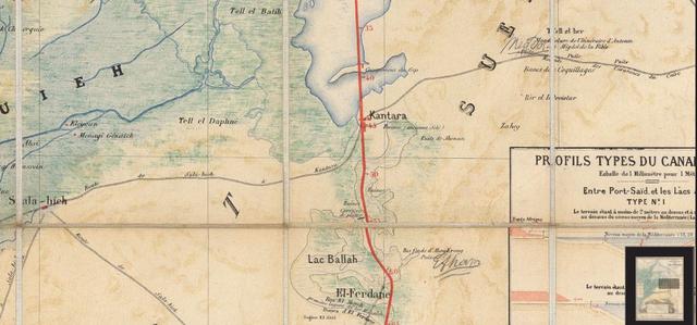
The below French-made map of the Suez Canal, made in 1869, shows that the Qantara Land Bridge or Isthmus was subject to flooding at times, as is shown by the blue-green hatchings just to the southwest of Kantara, and that the Caravan route from Egypt to Syria, via Gaza, was subject to periodic flooding in this area. Some scholars understand that this caravan route was known in antiquity as the Way of Horus for the Egyptians and the Bible knew it as The Way to the Land of the Philistines, as it ends at Gaza. On this map appears a site, just east of Kantara labeled Tell el Her, could this be Pi-Ha-Hiroth of the Bible? The Greek Bible, the Septuagint, renders Pi-Ha-Hiroth as Heiroth in Numbers 33:7 "...encamped at Heiroth's mouth, which is opposite Beelsepphpon, and they encamped opposite Magdolos. And they set out from before Heiroth and crossed through the middle of the sea into the wilderness..." (p.138. Albert Pietersma and Benjamin G. Wright, Editors. A New English Translation of the Septuagint. Oxford University Press. 2007) Could the "mouth" of Heiroth be referring to the inlet on the Qantara Land Bridge that connects Lake Menzalleh with Lake Ballah? It is via this inlet that Lake Ballah receives the Nile Flood Waters entering Lake Menzalleh. The Aramaic version of the Bible, the Peshitta, renders Pi-ha-Hiroth as the "inlet/canal of Kheritha" noting that it is dry at low water or low tide: Exodus 14:2, 9 "...encamp by the inlet of Kheritha, between Migdol and the sea, in front of Baal-zephon; opposite it shall you camp by the sea..Pharaoh...overtook them encamping by the inlet of Kheritha, before Baal-zephon..." Whereas Numbers 33:7 says "entrance of Heritha, the canal," "...encamped at the entrance of Heritha, the canal, which is before Baal-sephon; and they encamped before Migdol. And they departed from the entrance of Heritha and passed through the midst of the sea into the wilderness...of Etham and encamped in Morath." (George M. Lamsa's Translation From the Aramaic of the Peshitta. Holy Bible From the Ancient Eastern Text. Harper and Row, San Francisco. 1968. Original Copyright 1933, A.J. Holman and Co.) Footnote #1 on page 81, to Exodus 14:2, says: "Dry at low tide."
If one wants a location that saw chariots, on regular basis, cross a body of water subject to drying up, and to flooding, the Qantara Land Isthmus, the Way of Horus, seems to be a viable candidate for Pi-ha-Hiroth. Both Lake Menzaleh and Lake Ballah, have reeds and marsh grasses, via the Nile floods. Yam in Hebrew can mean a "lake" as well as a "sea", as for example, the Dead Sea being a lake, and the Sea of Galilee being another Lake. These reed-choked lakes could qualify as Yam Suph, Sea of Reeds.
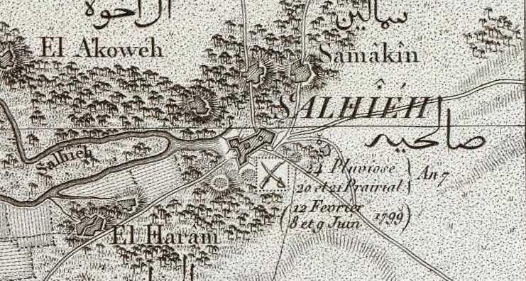
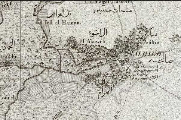
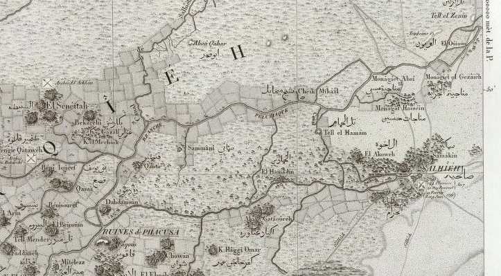
Below, map of Salhieh (1799) showing three unoccupied mounds south of the Arab fortress and settlement, the Nile ends west of the Arab fort. Are these 3 mounds ancient Tjaru and Sile? (Flle 30. Bubaste, Salhieh. scale:1:100,000. Paris. published in 1826, but surveyed in 1799. Description de l'Egypte). The French commentary suggests the French fought Egyptian forces here twice, in February and in June of 1799. Five major roads or tracks converge at Salhieh. Today it is famed for its date-palm plantations and the quality of its dates. Because the Nile flooded annually it was necesary for the cities and villages in the Delta to be built on mounds which became in effect small islands surrounded by the Nile in the form of a great sea. Perhaps this why so many Delta villages in Arabic are called Gizeret or Jizereh "island" and the Nile is called Bahr "Sea"? The canals which provided this sea are also called bahr as well. The French map (1799 survey) clearly shows all the villages of the Delta as on mounds to avoid the annual inundation.
It makes sense that Tjaru, Sile should be atop a mound too to avoid the flooding. Was there a bridge linking the mounds together when the Nile was in flood stage? The below map shows 3 mounds north of the Arab fort if one inclues Samakin and 7 mounds south of the fort, if one inludes El Haram. Test trenches sunk in all 11 of these mounds, including the mound the Arab fort sits atop, would determine if any are of New Kingdom to Roman times.
Professor Hoffmeier noted (2006) that the bas-relief of Seti shows the Tjaru fortress to be _east_ of (viewer's left) the Ta Denit waterway. Egyptians await his arrival in Egypt, on the west side of the waterway. I note that the below Arab fortress is _east_ of the Nile just as the Tjaru fortress is _east_ of Ta Denit. Various scholars render this fortress as Tjaru, Djaru, Zaru, Djel, Zel, Sile. Perhaps Sile is Salhieh?
Hoffmeier:
"The actual writing of Fortress of Tjaru (htm n t*rw) on the scene occurs on the building on the left side of the water, with another building complex on the right side of a bridge or dike."
"...dig a canal (dnit) to its...sm (y) dnit or sd mdnit, meaning "dig a canal"..."
James K. Hoffmeier."The Walls of the Ruler" in Egyptian Literature and the Archaeological Record: Investigating Egypt's Eastern Frontier." Bulletin of the American Society for Oriental Research. Aug. 2006.
Hoffmeier also notes that denit can be translated "canal" and to the degree that the Delta is a land crisscrossed with canals perhaps it could have been known to the Egyptians as Ta Denit, "the land of canals" (ta= "land," denit= "canal"?, as in Ta Kens, "Land of the Bow," i.e.. Egyptian Cush, and Ta Neter/Neuter, "Land of God," an eastern country)?
If the 3 mounds south of the Arab fort are ancient Egyptian tells could they represent the 3 structures associated with Ta Denit? The Seti relief shows two stuctures _east_ of the canal/waterway, then a bridge over the waterway, and a structure _west_ of the waterway. Are the 2 easternmost mounds Tjaru and the structure before the Ta Denit waterway? Is the westernmost mound the western structure shown on the Seti bas-relief? If so, then the remains of a stone bridge should exist between the westernmost mound and the mound preceding it.
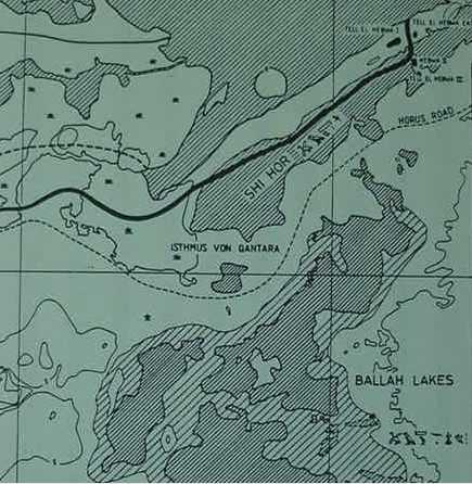
Below, Bietak's map showing a branch of the Nile passing through a lagoon he labels as Shi Hor, and then turning north to empty into the Meditarranean Sea. Note the upper right corner of this map showing the Nile branch it passing between Hebua I (viewer's left) and Hebua II (viewer's right). It is this feature that Hoffmeier suggests is Seti's Ta Denit waterway (for the below map cf. Fig. 1. "Map of the Eastern Delta and a reconstruction of the ancient environment and Nile branches." facing p. 3. Manfred Bietak. Avaris, The Capital of the Hyksos, Recent Excavations at Tell el-Dab'a. London. British Museum Press. 1996). My critique: If the below map's Horus road is correctly rendered invaders could bypass Hebua I and II and attack the Egyptian delta. Another problem: No Persian, Greek or Roman occupation levels at Hebua I and II, which mitigates against they being Roman Sile of the 4th century AD texts.
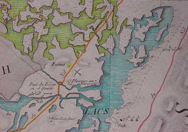
Below, a French-made map, based on Napoleon's cartographers work circa 1796, showing the canal linking Lake Menzalleh to Lake Ballah, the bridge site being called in French, Pont du Tresor ou el Qantir. I have not been able to determine when the canal was made under this bridge, whether it was in ancient Egyptian antiquity or the Middle Ages? The map shows two ruin sites on either side of the Caravan Track, just north of the Bridge. I do not know how old these two ruin sites/mounds are.
Below, a map of 1838/1841 by the American explorer Reverend Robinson showing the Qantara isthmus to be subject to flooding in his day.