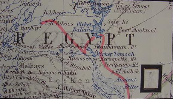
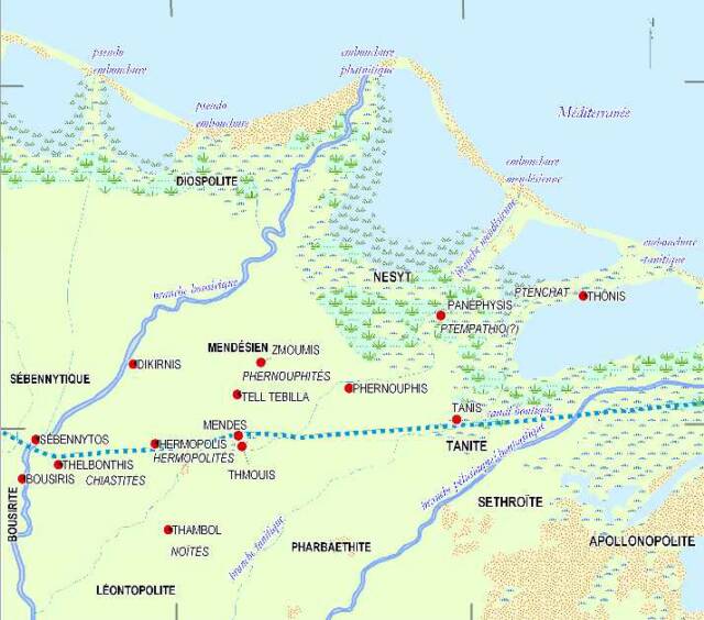
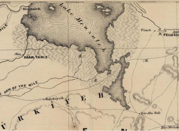
Map of Israel's crossing of the Red Sea at Ras el Ballah, "Cape Ballah" (Baal-Zephon?)
or Qantara and Lake Menzaleh?
20 November 2009 (Revisions through 27 October 2021)
Exodus 14:21 and 27 has a sea being pushed back by a strong east wind during the night, then, in the morning, with the wind dissipated (?) the sea "returns to its strength" and refills its formerly empty bed. "Where" was such a phenomenon "documented"? Eventually I found an account of the eastern half of Lake Menzaleh having its shallow waters pushed back by a gale force east wind exposing its lake bottom in January of 1882. It appears then that such a phenonemon is documented for shallow Egyptian marsh-lakes, Menzaleh's waters being generally 4 to 7 feet in depth with a few exceptions according to European visitors to the area in the 1800's.
Red Sea in Hebrew is called Yam Suph, yam= sea, suph= reed, "sea of reeds," suggesting an area possessing a fresh water environment for the reeds and marsh grasses to grow in, suiting the area of Lake Menzaleh.
Professor Humphreys (2004) sought to explain the drying up the Red Sea via physcial phenomena. He argued that "wind setdown" was the mechanism that created a passage in the sea. He said this worked only on large bodies of water (he noted it being documented at Lake Erie in the United States). Wind setdown "removes" water whereas wind setup "adds" water. He noted some thought the crossing was at the Gulf of Suez. He dismissed this location however because only a wind from the northwest could blow back this gulf's waters exposing dry land and the Bible said it was an east wind. He then noted that at the Gulf of Aqaba it would take a wind from the northeast to blow black the waters and expose the sea's bottom. He favored Aqabah as the crossing point of the Red Sea, despite the fact that an east wind could not blow back the gulf's waters only a northeast wind could do this. He was apparently unaware of the 1882 report of an east wind blowing back Lake Menzaleh's waters in this lake's eastern sector near the mouth of the Suez Canal. This lake is roughly 43 miles in length and 12 miles wide so it is big enough for wind set-down to work (cf. pp. 246-252. Colin J. Humphreys. The Miracles of Exodus: A Scientist's Discovery of the Extraordinary Natural Causes of the Biblical Stories. HarperCollins. 2004)
A British officer who lived in Egypt reported a phenomenon that somewhat paralled the Exodus account as related by Professor Kent (1914) of Yale University:
"...Major-General Tulloch, who states that the shallow waters of Lake Menzaleh, which lies only a short distance to the north and is subject to the same conditions, were driven back by the wind for seven miles, leaving the bottom of the lake dry (Journal of the Victorian Institute, Vol. XXVIII, p. 267, and Vol. XXVI, p. 12)."
(pp. 113-114. Charles Foster Kent. Biblical Geography and History. New York. Charles Scribner's and Sons. 1914, 1916, 1926)
C.R. Conder (1915) stated that Tulloch beheld this wonder in 1882 (the Suez Canal was completed by 1869):
"In 1882 Sir Alexander Tulloch saw the waters of Lake Menzaleh driven back more than a mile by the east wind."
(C. R. Conder. "Exodus, the Route." James Orr. Editor. The International Standard Bible Encyclopedia. 1915)
Professor Haupt of Johns Hopkins University (1904) noted that the receding water was in the eastern portion of Lake Menzaleh, near ancient Pelusium and the mouth of the Suez Canal (the mud-flats area west of Pelusium and et-Tina, which as late as 1856 was subject to flooding by the Nile which left its characteristic dark silt):
"In my paper on Archaeology and Mineralogy...I mentioned the fact that Major-General Tulloch observed that under a strong east wind the shallow waters of Lake Manzaleh at the northern entrance to the Suez Canal receded for a distance of seven miles. There is therefore no reason for doubting the historical character of the passage of the Red Sea."
(p. 149. Paul Haupt. "Moses' Song of Triumph." The American Journal of Semitic Languages and Literatures. Vol. 20. No. 3. April. 1904)
Another account has the 1882 east wind diminishing the water level by 6 feet (my note: A depth capable of drowning Pharaoh's army!):
"Major General Tulloch of the British Army (Proceedings of the Victoria Institute. XXVIII, pp. 267-280) reports having witnessed the driving off of water from Lake Menzaleh by the wind to such an extent as to lower the level 6 feet, thus leaving small vessels over the shallow water stranded for a while in the muddy bottom."
(BibleExplore.Com, "Red Sea," on the internet)
A variance of 7 feet was documented for Lake Erie in the United States between Buffalo New York and Toledo, Ohio:
"The power of the wind to affect water levels is strikingly witnessed upon Lake Erie in the United States, where according to the report of the Deep Waterways Commission for 1896 (165, 168) it appears that a strong wind from the southwest sometimes lowers the water at Toledo Ohio on the western end of the lake to the extent of more than 7 feet, at the same time causing it to rise at Buffalo at the eastern end a similar amount..."
A description of Lake Menzaleh (1868) has its depth as 4-5 feet, 43 miles long, 12-11 miles wide and full of marsh reeds:
"...Lake Menzaleh...the bottom is a mixture of mud and sand, generally covered in reeds, but quite level; so that the greatest depth of the lake does not vary more than 6 or 8 inches, being rarely much under 4 feet, and seldom materially above it, except where the sea enters."
(p. 386. General Francis Rawdon Chesney. Narrative of the Euphrates Expedition: Carried on by the Order of the British Government During the years 1835, 1836 and 1837. London. 1868)
Bonar (ca. 1843?) understands Lake Menzaleh's deeper parts are 10 feet, but mostly 4 to 5 feet:
"...Lake Menzaleh...It is nowhere more than ten feet deep, and in general only four or five...at evening we entered a canal among immense reeds...we reached San about ten...the ruins of Zoan..."
(Andrew Bonar. The Biography of Robert Murray M'Cheyne. Note: M'Cheyne lived 1813-1843)
("Red Sea," BibleExplore.Com)
Tulloch's account of the eastwind blowing away Lake Menzaleh's waters appears in his published military memoirs of 1903, he witnessed the event apparently at the end of January of 1882 while he was at Port Said inspecting the Suez Canal's embankments for acts of sabotage. The dried up Menzaleh Lake was to the west side of the canal "as far as the eye could see" (Haupt's 7 miles?). Of interest here is that the wind apparently began blowing during the day, continued all through the night and was still blowing in the morning and the lake bed was empty. Yahweh, overnight, dries up Yam Suph, and Lake Menzaleh, overnight, is dried up too:
""We landed at Port Said the end of January...I made a curious discovery. An easterly gale came up very rapidly, and at last was so strong, driving the sand from the dry side into my face, that I had to cease work. Next morning the wind having a good deal gone down, I went on to the canal bank again, when, to my astonishment, I noticed that Lake Menzaleh on the west side of the canal had disappeared beyond the horizon in that direction, and that the Arabs were walking on the mud where the day before large boats had been floating. When thinking over this extraordinary effect of wind on shallow water, it suddenly flashed upon me that I was witnessing a similar event to that which had taken place between three to four thousand years ago, at the time of the passage of the so-called Red Sea by the Israelites. Subsequently, when I had time for it, I examined the shores of the Bitter Lakes, and came to the unquestionable conculsion that the Red Sea of Pharaoh's day extended to the head of the Bitter Lakes, and it was here the passage took place, and that the description of it in Exodus is literally correct, word for word."
(pp. 245-246. Major-General Sir Alexander Bruce Tulloch, K.C.B., C.M.G. Recollections of Forty Years' Service. London & Edinburgh. William Blackwood & Sons. 1903)
My note: In the 1880s many scholars believed that the head of the Gulf of Suez in antiquity was at Lake Et-Timsah, which included the Bitter Lakes, hence, probably Tulloch's notion that the Red Sea Crossing was at the Bitter Lakes. Today we know the head of the Suez Gulf has always been at its present location at least since the days of the Pharaohs. The evidence? Archaeologists have found ancient Egyptian mining camps on the Suez Gulf's shore revealing its level today was nearly the same 5000 years ago.
DeLesseps visited in 1856 Pelusium before the Suez Canal was built and crossed the mud-flats on camels which sank a bit into the mud, by December no sinking occurred:
"The rise of waters this year had been less than usual, and had dried up quickly, and at the end of December we crossed these seas of mud dry-footed and without our camels sinking into it at all."
(p. 47. Joseph Everett Nourse. The Maritime Canal of Suez: From its Inauguration, November 17, 1869 to... Naval Historical Foundation. Washington, D.C. 1974, using source material from 1884?)
I note that such mud could clog pharaoh's chariot wheels. The "drying up" of a sea's bed by an east wind pushing the waters away near the Pelusium and et-Tina mud-flats (which are subject to Nile inundations) seems to _identify_ the
"pre-biblical source" for the biblical story as being this area.
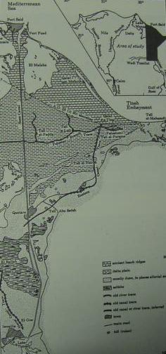
Below a map from the 1897 Encyclopedia Britannica showing the northern mouth of the Suez Canal, where in 1882, an east wind blew away a portion of Lake Menzaleh's waters for a distance of 7 miles from the vicinity of the canal's entry point. I have set my compass to create a 7 mile arc from Port Said, the canal's entry point, to show the viewer what 7 miles looks like from any given direction from Port Said. I have colored the exposed lake bed yellow (I am using the map's scale, marked off in numbers every 2 miles, 0-10, in the upper right corner to determine the 7 mile arc from)
The area exposed "may have been" even greater extending along the whole of the eastern coast of Menzaleh from Said to Qantara/Kantara if the "line of view" from Said is restricted to only 7 miles? The 4/5 foot drop in water on the east side of Menzaleh probably caused a 4/5 foot height increase on the west side of the lake as happened at Lake Erie. Note: Tulloch said it was on the west side of the Suez Canal that the waters of lake Menzaleh had blown away; the canal's high embankment would prevent the lake water east of the canal from being blown away. So the "yellow" area on the below map should more properly be restricted to the area west of the Suez Canal's entry.
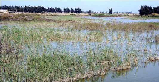
Below, a photo of a marsh area "near" the Ballah Lakes, Israel's crossing of the Reed Sea probably resembled somewhat the below scene (without the dwellings and trees).
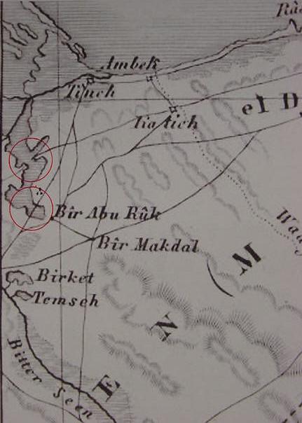
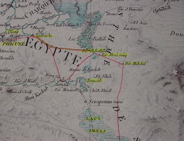
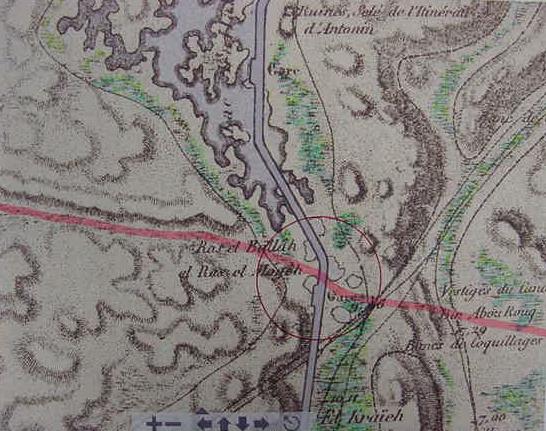
Below, a map of Ras el Ballah, alternately called Ras el Moyeh ("Cape of Water"), on the west side of the Ballah inlet showing water on either side of two tracks. The Pink track from Salhieh in the delta takes one north to Qatieh in the northern Sinai; the Orange route goes to Bir Abou Rouq. I understand that Baal-Zephon is Ras el Ballah and
Pi-ha`hiroth is the northern opening or "mouth" to the El Kraieh marsh east of Ras el Ballah. Israel probably used the orange track "to cross the Reed Sea" (Ex 14:21-22). Israel camped before Baal-Zephon (Ras el Ballah) on the orange route, west of the marsh-ford in front of Ras el Ballah. Going from west to east, as Israel passed over the dried up marsh-ford, she saw a "wall of water" on either side, the deeper waters of the Ballah inlet colored in a deeper blue, the lighter blue lined areas are marshy ground with green marker for tufts of sedge or swamp grasses and reeds, hence its name Yam Suph "sea of reeds" (Exodus 14:22). Note that this track does cross the marsh-swamp, there apparently was a shallow ford at this location which "might" dry up at times (Map of 1826, Paris, France. Titled "Canal de Suez" sheet no. 31. Surveyed 1797-1799 by Napoleon Bonoparte's Corps of Engineers and Cartographers). Note: Bir Abou Rouq is transcribed variously as: Abou-el-Rouq; Abou Erouq; Abu Ruk; Abu Rukk; Bir Abou el Rouq; Bir Abou Erouq; Bir Abou Rouq; Bir Abu el-Uruq; fountaine d' Abou el `Arouq (cf. p. 1132. Vol. 2. Herbert Verreth. The Northern Sinai From the 7th Centrury BC till the 7th Century AD, A Guide to the Sources. Leuven, Belgium. 2006. Available for download on the internet as two PDF files). The transcription Erouq, for me, most closely parallels the biblical Hiroth (Pi-Ha`Hiroth). Erouq is described as possessing "two wells and a few palm trees" according to Verreth, and cared for by a Bedouin family. So Hiroth appears to be possibly preserved in Erouq. The problem? The proper pronounciation in Hebrew is not Hiroth, its Chiroth/Khiroth which is best preserved at the marsh of El Kraieh (Karach, Karash on various maps). Verreth translates Ras el Ballah as "Cape of [lake] Ballah," noting it is alternately called Ras el Moyeh "the Cape of the Lakes" (Verreth. p. 827. Vol. 1) but I understand "lake" is birket while moyeh means "water" (Aramaic moyeh= water; Hebrew: mayim= water; Egyptian: mu= water; Arabic ma= water; vulgar Egyptian: moyeh= water), so I would translate "Cape of Water" or "Headland of Water." This headland appears on a map of 1885 as Ras el Ballah el Ras el Moyeh, "the headland or cape of Ballah/Water." Ballah's water is from Nile flooding via Lake Menzaleh; Menzaleh is classed as a "salt-marsh" (17% salinity in 1926), so Ballah would be a salt-marsh too.
Exodus 14:22 RSV, "...Israel went into the midst of the sea on dry ground _the mayim_ being a wall to them on their right hand and on their left." Both "water" and "waters" in Hebrew is mayim (Strong 4325), is there a relationship here to Ras el Moyeh, "the Cape of the Water"? The "waters" Israel passed through on her right and left hand as shown on the above map? In other words "the water/waters" Israel passed through at Baal-Zephon (Ras el Ballah?) are alluding to Ras el Moyeh, "the Cape of Water."
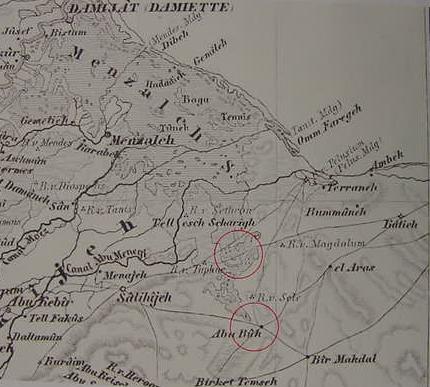
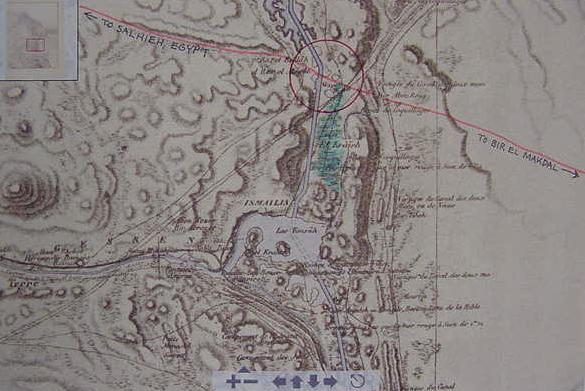
Below, another view of the track from Salhieh on the edge of the Egyptian delta (viewer's left, not shown on this image) to Ras el Ballah, "the Headland of Ballah," which lies on the west side of the Ballah inlet and its marshes. To the ESE of Ras el Ballah is Bir Abou rouq (marked by two concentric red circles, other, later maps' `Ruk, Aruk, Erouq, `Uruq). A track in orange marker passes through the southern swamps of the Ballah inlet east of Ras el Ballah to Bir Abou Rouq. At Rouq one has two tracks in orange to go south to Lake Et-Timsah (Etham?). The western track goes directly to Lake Et-Timsah, the middle track (orange) passes by Timsah on its east side headed for the Bitter Lakes region. The far right orange track heading east of Bir Abou Rouq takes one to Bir el Makdal (probably Pi-ha`hiroth's and Baal-Zephon's Migdol). Alternately, Migdol might be the below map's conical "Ruines" tell ENE of Ras el Ballah. Without explanation Hazlitt identifies Migdol, classical Magdolum, with Ras el Moyeh! If he is correct then Migdol/Magdolum at Ras el Moyeh puts Israel at Ras el Ballah (cf. p. 212. "Migdol." William Hazlitt. The Classical Gazetteer of Ancient Geography, Sacred and Profane. London. Whittaker & Company. 1851). As Israel, after crossing Yam Suph, is headed for the wilderness of Etham, Israel could have taken any of the three orange tracks at Bir Abou Rouq to Birket Et-Timsah. The first orange track going south (viewer's left) from Bir Abou rouq takes one directly to Et-Timsah via Marais de Karach (the 1799 marsh of Karach, 1885: El Kraieh), the second orange track headed south bypasses Et-Timsah's east side. The third orange track (viewer's right) continues to Bir El Makdal (my proposal for Migdol of the Red Sea Crossing). From Makdal a track goes due south headed for the Bitter Lakes called Murrat in Arabic (The Exodus' "bitter waters of Marah"?). Bir el rouq (`Ruk, `Aruk, Erouq, `Uruq) may preserve the Exodus'
Pi-ha`hiroth _if_ Hiroth is the correct pronounciation, if _not_, then Chiroth/Khiroth is preserved in El Kraieh (1885 map). In any event, Israel had to cross through or "ford" the marshy lower portion of the Ballah Inlet east of Ras el Ballah to get to Rouq and continue south to Etham/Timsah and Marah. From Pi-hahiroth, Baal-Zephon, and Migdol and the crossing of the Reed Sea Israel spent three days crossing the wilderness of Shur/Etham. She had herds of cattle (Ex 12:38) and cattle drives to Abilene, Texas did not exceed more than 10 to 15 miles a day. If the "waters" of Marah (Hebrew plural and singular: mayim) is an allusion to more than one water source the two salt-marshes of Murrat, today's two Bitter Lakes would seem to fit the bill; Murrat in Arabic means "bitter" and Hebrew Marah also means "bitter." Three days to cross the wilderness of Shur/Etham from Pi-ha`hiroth at 10 to 15 miles a day suggests that the crossing point of the Red Sea is roughly 30 to 45 miles north of some location at the two Bitter Lakes. 15 miles south of Bir Abou rouq (Pi-ha`hiroth?) we are in the vicinity of Lake Et-Timsah (Etham?); at 25 miles we are at the northern part of the Great Bitter Lake (al-Buhayrah al-Murrat al-Kubra); at 40 miles we are at the Little Bitter Lake (al-Buhayrah al-Murrat as-Sughra); at 45 miles we are just south of the Little Bitter Lake
Please Click Here to access an interactive version of the below map and see the Ballah inlet in greater, clearer, more focused detail.
The Jews in Jerusalem would know of these sites (Baal-Zephon/Ras el Ballah, etc.) via caravan merchants as they served as major sign posts along the way for the caravans plying their trade goods back and forth between Canaan/Judah and Egypt.
The Jews apparently, by 562-560 BC when Genesis-2 Kings appears in its final format, understood that Yam Suph extended from in front of Egypt (Exodus 13:18; 14:21-22, 27) to the Solomonic ports of Elath and Ezion-Geber (Nu 33:35, 36, De 2:8, 2 Ch 20:36); a "huge" sea indeed, in their imagination, but they had, in error, confounded and conflated the reed marshes of Menzaleh, Ballah/Moyeh, Karash/Kraieh, Timsah and the Bitter Lakes with the gulfs of Suez and Aqabah. So the crossing of a shallow marsh ford under the eastern slopes of Ras el Ballah (my Baal-Zephon), which on occasion was probably dry, became Israel crossing the Reed Sea/Yam Suph extending from before Egypt all the way to Edom!
In other words, because a great sea was envisioned as east of Egypt and extending to Edom, the crossing on dry land of this sea under the slopes of Baal-Zephon (Ras el Ballah) became Israel's God performing a wonderous miracle, allowing his people to flee Egyptian bondage. The humble marsh-ford at Ras el Ballah (Baal-Zephon) had _mistakenly_ come to be envisioned as the great depths of the sea of Suez and Aqaba and because of this error, a mighty miracle had been performed by God, the drying up of the Reed Sea for his people's benefit and salvation.
I just now finally realized that the _only_ event that people would regard as "a miracle" would be the sudden drying up of a portion of Lake Menzaleh for a distance of 7 miles as reported by Tulloch. That is to say the sea that dried up under a wind's influence _is_ Lake Menzaleh rather than the Ballah inlet!
Imagine yourself in the center of circle 7 miles in diameter: whichever direction you turn and face: north, east, south or west for a distance of 3 1/2 miles all you see is lake bottom where formerly there was water (assuming you can see 3 1/2 miles away). This would have to be regarded as a miraculous event worth remembering and recounting to anyone you chanced to come into contact with. To the degree that the Ballah Inlet is an extension of Menzaleh the two lakes probably came to conflated together into one great sea, Yam Suph, extending from Menzaleh to Edom. That is to say miracle of an east wind drying up the eastern half Menzaleh came to be conflated with the drying up of the Ras el Ballah ford which is an extension of the eastern half of Menzaleh.
The main road from Egypt to Canaan and Judah passes by the east side of this lake. The local natives would surely pass on to the caravans passing over Qantara to Egypt the story of their Reed Sea (marshland) being dried up for a distance of eight miles by a wind and the caravaneers and merchants would pass this story on to the Jews in Jerusalem. So the Red Sea (Reed Sea, Yam Suph) that dried up was Lake Menzaleh, or at least a portion of it, probably the eastern part near Qantara.
As the Qantara traderoute is the _major_ track leaving Egypt for Canaan and the most famous of the tracks going to and from Egypt, it would make sense that the Jews would associate the leaving of Egypt by their ancestors with this track which skirts the southeast edge of Lake Menzaleh. So the drying up Menzaleh or a part of it _plus_ a major track leaving Egypt for Canaan, became Israel's Egyptian Exodus and the miracle of the drying up of the Reed Sea; the east side of Manzela is very shallow and not navigable and is full of marshes, reeds, and miry mud-flats under Moses. There is a problem: The Qantara crossing is on the biblical "way to the land of the Philistines" which the Bible says Israel did _not_ take (Ex 13:17). This leaves, then, by default, the Ras el Ballah route as the body of water Israel crossed north of Etham (Et-Timsah?) and Marah (the Bitter Lakes?).
Coptic pi-akhirot "place where the sedge grows" is another suggestion for Pi-ha`hiroth's Egyptian etymology (cf. the Jewish Encyclopedia on the internet). Sedge embraces various forms of marsh-growing plants including reeds and grasses. The appearance of a marsh with grasses and reeds in the midst of the Isthmus of Suez at Ras el Ballah and the El Kraieh marsh would be a remarkable sight for caravans crossing an otherwise arid wilderness from Judah to Egypt and would serve as a reference point for caravans which would cross this marsh-ford for Egypt.
Below, a map (1848) showing that two caravan tracks leaving Egypt for the town of Katieh (Qatieh) in the Sinai cross the Ballah inlet, an extension of Lake Menzaleh. The German cartographer has grossly over simplified this area as revealed in the above 1797-1798 maps of this region by Napoleon's cartographers, nevertheless, in _both_ cases, a track must cross a body of water, the Ballah inlet. The northern track crosses the water at Qantara (on pre 1860 maps rendered Kantara or Tresor), the southern track crosses the Ballah inlet between Ras el Ballah, west of the inlet and Bir Abu Ruk (1797 Bir Abou rouq) east of the inlet. Red circles mark the possible sites for the crossing of the Red Sea (the Ballah inlet) on each of the below maps. The northern crossing of the Ballah inlet at Qantara is on the biblical "way to the land of the Philistines," a route the Bible says Israel did _not_ take (Ex 13:17), leaving by "default" the southern crossing of the Ballah inlet at Ras el Ballah. This map shows the area about Tineh (et-Tineh) and Pelusium (not on this map) were marshy and subject to inundations of the Nile before the Suez Canal was built. In this very area in 1882 near the mouth of the Suez Canal, Lake Manzelah's bottom was exposed for 7 miles by an east wind.
Below, 1832 map, John Arrowsmith, London, notes "Inundations of the Nile" from Lake Menzaleh to Birket el Karash (El Kraieh marsh on 1885 map) south of Birket el Ballah.
Below, 1853 map, Heinrich Keipert, Germany showing three tracks crossing the Ballah inlet. There are _two_ northern tracks from Taphne (Biblical Tahpanes, a colony of Greek mercenaries; Arabic: Safnas on an 1802 map) one to Pelusium the other to Katieh via the "Ruins of Magdolum" (Tell es Smoot on other 19th century maps). The third track is at Bir Abu Ruk (1797-1799 Bir Abou rouq) near the south end of Lake Ballah.
For those wishing to argue Baal-Zephon is recalling Greek Dafnae, biblical Tahpanes, Arabic Safnas (1802 map) and Migdol being Tell es Smoot/Classical Magdolum (?) the Qantara land bridge would be "the crossing point" of the Red Sea.
The second possible location for the crossing of the Red Sea would be at Ras el Ballah (Baal-Zephon?).
Undoubtedly the Qantara crossing is the "major" exit point from Egypt, it was heavily guarded and several Forts or Migdols exist near this route that could be the Bible's Migdol. In favor of Qantara over Ras el Ballah is that the Qantara land bridge is nearer to the drying-up of Lake Menzaleh by a wind and the landbridge's height would provide a better view for Israel when she crossed over it on dry land and saw two walls of water on either side of her, the left-hand wall of water would be Lake Manzaleh and its marshes on its eastern periphery while the right-hand wall of water would be the Ballah inlet and its marshes. Against the Qantara proposal is that this land bridge never was submerged so an east wind pushing back waters here is not called for. Also against this proposal is that Qantara is part of the Way to the land of the Philistines, a route not taken by Israel.
Both bodies of water (Menzaleh and Ballah) possess marsh and reeds making them candidates for the Reed Sea or Yam Suph. The Ballah inlet is part of Lake Menzaleh, in Jewish eyes, when Israel crossed "the sea that dried up by a wind" (the eastern shore of Menzaleh) this sea existed on both the Menzaleh and Ballah sides of the crossing point.
Some notes on Yam Suph:
Yam Suph (the Reed Sea) for the Exilic narrator (562-560 BC) apparently embraced (1) the marshes of Lake Menzaleh, (2) the marshes of Birket Ballah, (3) the marshes of Birket Karach/Karash, (4) the marshes at Birket Timsah, (5) the marshes of the two bitter lakes, (6) the gulf of Suez, and (7) the gulf of Aqabah.
When Israel left Rameses she headed for the "way of the wilderness of Yam Suph" (Ex 13:18) at Etham (Ex 13:20), Birket Timsah, today's Et-Timsah, a marshy lake which periodically received its freshwater via Nile inundations before the Suez Canal was constructed in the 1860s. Then Israel turns about to Pi-ha`hiroth and camps at Yam Suph (Ex 14:1-2) leading Pharaoh to think they are lost in the wilderness west of Yam Suph, from Pi-ha`hiroth to Etham (Ex 14:3). After crossing Pi-ha`hiroth/Yam Suph they backtrack three days to Marah via the wilderness of Shur named after Abu Suweir (?) west of Lake et-Timsah where caravan routes intersect each other, today's Isthmus of Suez from Qantara to the Bitter Lakes called Murrah, meaning "bitter" in Arabic (Ex 15:23). However this 3 day backtrack is called the wilderness of Etham in Numbers 33:8. Both are correct as Shur (Hebrew shuwr) is probably Abu-Suweir-by-Lake-Et-Timsah. I suspect that Suweir/Timsah are but alternate names for the Isthmus of Suez between Ras el Ballah and Marah (the Bitter Lakes). Then Israel camps at Elim (Ayun Musa?), day 4 since the Red Sea crossing at Ras el Ballah ( Ex 15:27), Day 5 Israel camps at Yam Suph, south of Elim/Ayun Musa on the shore of the gulf of Suez (Nu 33:10-11), then they camp in the Wilderness of Sin (Nu 33:11). Israel later leaves Kadesh-Barnea to camp at Ezion-Geber on the Yam Suph (Nu 33:35-36). Numbers 21:4 has Israel at Mount Hor near Arad in the Negeb and Edom when Israel journeys to ":the way to the Red Sea" (Ezion-Geber). By comparing Exodus 14 with the Numbers 33 itinerary it is obvious to me that Yam Suph was _incorrectly envisioned_ as extending from Lake Menzaleh to the Gulf of Aqabah and Edom without any landbridge breaks in it (land passages do exist south of Ballah, south of Karach/Karash, south of Timsah, and south of the Bitter Lakes above the Suez Gulf but the Exilic narrator apparently was unaware of them. It is the pushing back of the sea's waters by a powerful east wind that allows Israel to escape Egypt and cross over into the Sinai. Because of the depth of Yam Suph at Elath and Ezion-Geber (the Gulf of Aqabah) Pharoh's army was portrayed as sinking in the depths of the sea when it returned to its strength in the morning watch when the wind stopped blowing (not a tidal action, not a tsunami, but an east wind setdown). The reality was that the shallow waters, varying from one to five feet on Lake Menzaleh's east side were what was blown away by a wind, but the Exilic narrator was apparently unaware of this, he knew only of Yam Suph/Aqabah's deep waters.
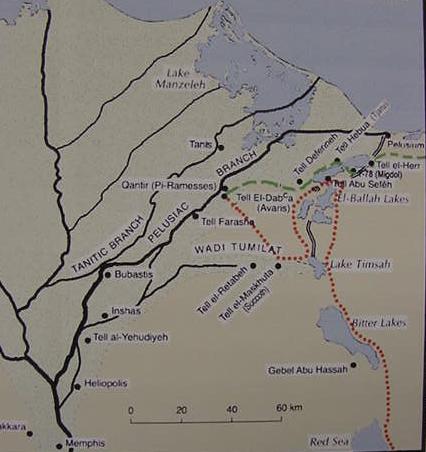
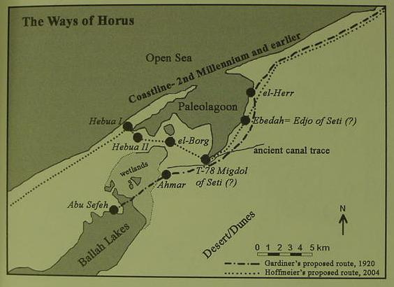
The below map from the Bible and Spade website, based on Hoffmeier's research (figure 1. James K. Hoffmeier. Ancient Israel in Sinai, the Evidence for the Authenticity of the Wilderness Tradition. Oxford University Press. 2005).
I reject the notion of there being 3 Ballah Lakes as the maps made before the 1865 Suez Canal changed the Ballah topography reveal it was merely an inlet of Lake Menzaleh, the crossing of the Red Sea being Ras el Ballah, "the headland of Ballah," or "Cape Ballah," a prominent height or elevation west of the Ballah inlet crossing.Hoffmeier shows the Qantara landbridge area as being the site for Israel's crossing of the Reed Sea, yet the Bible says Israel avoided this location as it was part of the "way to the land of the Philistines." Contra Hoffmeier I understand that the area north of Qantara was periodically covered in water from Nile inundations, a shallow freshwater lake with marsh grasses and reeds and that this is "where" the sea's bottom was exposed by a wind for 7 miles as noted by Tulloch. So via a series of errors, not understanding the real geography of Yam Suph, the shallow marshes east of Egypt were confused and conflated with the depths of Yam Suph at Elath and Ezion-Geber (the Gulf of Aqabah).
I find rather ironic that this confused geography is a "foundation stone" of sorts for Judaism, Christianity and Islam: Israel's Red Sea Crossing via a wind blowing back a sea's waters exposing its bed.
Below, my route of the Exodus in pink marker -compare it with Hoffmeier's above map- Hoffmeier has the Crossing of the Reed Sea in the northern sector of Ballah, "the way to the land of the Philistines," whereas I have the crossing in the southern sector of Ballah; from Goshen (Fakoos) to Etham (Birket Tamsah, modern Lake Et-Timsah), "turning about" from Etham at the "edge of the wilderness" (lands receiving Nile water) to Pi-ha`hiroth by Baal-Zephon (Ras el Ballah, "the headland of Ballah," not on this map but west of the track crossing the southern tip of Birket Ballah, west of Beer Mooktool/Migdol (?). I associate the waters (mayim, can mean both water or waters) of Marah with the two Bitter Lakes called Murrah, the Septuaginta's Merra (for the map cf. Keith Alexander Johnston, London, 1861 Map at the David Rumsey Historical Maps Archive on the internet).
Note: The ancient Egyptian language did not have the letter "L" instead they used "R." The word Baal-Zephon however does appear in inscriptions found in Egypt, not in Egyptian, but in _Greek_ at Tell Defenneh (Greek: Dafnae), a settlement for Greek mercenaries to guard Egypt's borders circa the 7th-6th centuries BC and into Greek Ptolemaic times of the the 3rd-1st centuries BC. This suggests for me that the word Baal-Zephon is really Greek, circa the 7th-6th century BC (the Exodus account being written in the Exile, in Babylonia circa 562-560 BC during the reign of the Neo-Babylonain King Evil-Merodach, Amel-Marduk, who reigned between those dates cf. 2 Kings 25:27), not Egyptian, and is "marker" that the Exodus account is very late (not written by Moses circa 1445-1404 BC for some Conservative Protestant scholars) and after the 7th century BC and settlement of Greek mercenaries at Dafnae (Jeremiah's circa 572 BC Tahpanhes Jer 43:7-9; 44:1; 46:14). Migdol or "fort" in Egyptian would be Maktar or Magtar.
Jeremiah suggests that following the fall of Jerusalem to the Babylonians some Jews fled to Tahpanhes, where they would have come into contact with accounts in Greek of a Baal-Zephon. It is also possible that Greek mercenaries stationed in Judah to pacify it after Egypt conquered it (after killing king Josiah at Megiddo who opposed them) the Jerusalem Jews learned of a "Ras Ballah" in the northern part of the Isthmus near a major trade route going into Egypt.
The Wikipedia on Baal-Zephon in Greek texts:
"Gmirkin (2006) also notes that a Ptolemaic era geographical text in the Cairo Museum mentions the sites Baal Zephon and Migdol, listing four border guard stations and fortresses, the third being called 'Migdol and Baal Zephon thought to be located on a route to the Red Sea Coast..."
Judaica Encyclopedia. Gale Group. Jewish Virtual Library:
"BAAL-ZEPHON... is identified with a Migdal Baal-Zephon mentioned in a papyrus from the Hellenistic period (Cairo papyrus 31169)... W. F. Albright has identified Baal-Zephon with the Egyptian port Taḥpanḥes (Daphne).
Michael Avi-Yonah
BIBLIOGRAPHY:
O. Eissfeldt, Baal Zaphon… (Ger., 1932); Bourdon, in: RB, 41 (1932), 541ff.; Albright, in: BASOR, 118 (1950), 17; EM, 2 (1965), 291–2; Aharoni, Land, 179; M. Dothan, in: Eretz-Israel, 9 (1969), 48–59. ADD. BIBLIOGRAPHY: H. Niehr, DDD, 152–54.
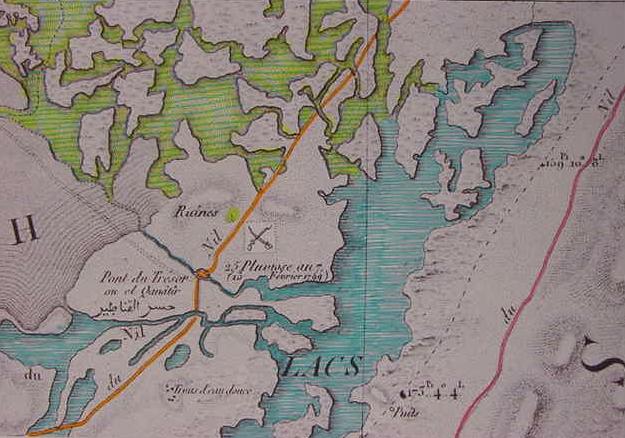
Below, two maps of the Qantara area, 1826, Paris Map. "Canal de Suez," Sheet 31, Surveyed 1797-1799. Blue is deep water, blue lines on yellow is shallower water. Marshes exist on many of the "islands" scattered all about. The Orange line is the Qantir route from Salhieh on the eastern edge of the Delta to Qatieh in the northern Sinai east of Pelusium. The Pink route links Salhieh to Qatieh as well but it passes the east side of the Ballah inlet and crosses via a shallow ford at the southend of the Ballah inlet east of Ras el Ballah for Salhieh. In either case, a "reed sea" or "marsh" must be _forded_ on both routes leaving Salhieh, Egypt for Qatieh in the northern Sinai. That is to say, one cannot get away from the Egyptians without "crossing" (fording) a reed sea or marsh (Yam Suph, the Reed Sea?) at either Qantara or Ras el Ballah.
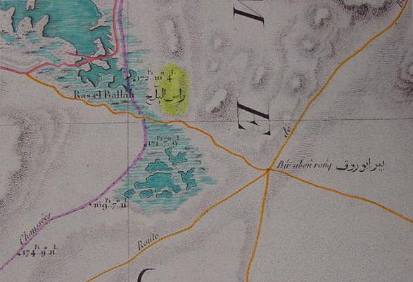
Below, a map of 1885 showing the Suez Canal traversing the Ballah Inlet. It is more detailed than the preceding French map surveyed in 1797-1799. "Ras el Ballah el Ras el Moyeh" is shown as being to the west of six small lakes, ponds, or pools. "Missing" on the below map is the track from Bir Abou Rouq to Ras el Ballah going to Salhieh on the 1797-1799 survey. The below map however shows the marshes of El Kraieh as extending to the six pools. When the missing track from the 1799 survey is superimposed on the below 1885 map it appears that the track passed between the six pools. Perhaps El Kraieh preserves Pi-ha`hiroth rendered by some as Pi-ha`Chiroth or Pi-ha`Khiroth? If so, then Israel, camped "before" Pi-ha`Khiroth, is on the west side of the six pools of water on the below map, then, later, she passes between them (?) to Bir Abou Rouq. Migdol is Bir el Makdal "at the end of the track" from Salhieh, Ras el Ballah, and Bir Abou Rouq. The 1799 survey reveals two important tracks from Bir el Makdal to Egypt: (1) The northeastern track: Makdal, Rouq, Ras el Ballah, Salhieh; (2) Belbeis via Wadi Tumilat to Makdal. So biblical Migdol, is a key reference point for caravans to and from the Egyptian delta from Salhieh and Belbeis and I believe it is a reference point for the location of Pi-ha-Khiroth (the marsh of El Kraieh 1885), bounded on the north by Ras el Ballah (Baal-Zephon?) and on the east by the track from Makdal to Ras el Ballah from Bir el Makdal (Migdol?). Click here to visit the below interactive version of the map allowing scrolling and magnifying. The Graeco-Roman Geographer Strabo said that areas of marsh and pools were called barathra, were the 6 pools at Ras el Ballah called barathra? Ezekiel's Pi-beseth in Egypt was called by the Greeks Bubastis, apparently Hebrew pi- can become Greek bu-? Is barathra a Greek rendering of Pi-ha-hiroth, the six pools of Ras el Ballah in a marshy setting? If so, then the Pi-ha`hiroth Israel camped "before" was the six barathra pools surrounded by marsh east of Ras el Ballah.
Strabo (Geography. Bk. 17.1.19-21):
"Pelusium itself is surrounded by marshes and pools, which some call clefts or pits (barathra)."
(p. 42. Vol. xliv. Robert Jameson. The Edinburgh New Philosophocal Review. Edinburgh, Scotland. October 1847 to April 1848)
TANAKH, The Holy Scriptures (1985. Philadephia & New York. The Jewish Publication Society):
Exodus 14:2
"Tell the Israelites to turn back and encamp before Pi-hahiroth, between Migdol and the sea, before Baal-zephon; you shall encamp facing it, by the sea...the Egyptians ...overtook them encamped by the sea, near Pi-hahiroth, before Baal-zephon...a strong east wind all that night...turned the sea into dry ground. The waters were split, and the Israelites went into the sea on dry ground, the waters forming a wall for them on their right and on their left...at daybreak the sea returned to its normal state..."
Numbers 33:7-8
"They set out from Etham and turned about toward Pi-hahiroth, which faces Baal-zephon, and they encamped before Migdol. They set from Pene-hahiroth [Pi-hahiroth] and passed through the sea into the wilderness; and they made a three-days' jpurney in the wilderness of Etham and encamped at Marah."
Pi-ha`hiroth is "between" Migdol and the sea:
The marsh of el Karieh is between Bir el Makdal (Migdol) and the el Ballah lake. Alternately, if the 6 pools east of Ras el Ballah are Barathra/Pihahiroth, they are "between" Bir el Makdal on the east and Ras el Ballah on the west.
Israel camps before Pi-ha`hiroth:
Israel is on the westside of the northern opening to the El Kraieh marsh; alternately, if the 6 pools are bartahra/pihahiroth, Israel camps west of these pools.
Israel is also camped "before" the sea and "before" Baal-Zephon:
Israel is east of Ras el Ballah and west of the Ballah inlet, 6 pools and El Karieh marsh opening.
Numbers 33:7-8
Pi-hahiroth "faces" Baal-zephon:
East of Ras el Ballah is the northern opening of the El Kraieh marsh (Pi-ha-Khiroth?) and the 6 pools (barathra/pihahiroth?).
Israel camps before Migdol:
Israel is on the westside if the Ballah marsh-ford and on the track which will take them to Pi-ha`hiroth (the northern opening of the El Kraieh marsh and 6 pools or barathra/pihahiroth) and will also continue to the end of the track at Bir el Makdal (Migdol is before Israel as it is at the end of the track Israel will use to cross Yam Suph (Ballah marsh) south of Baal-zephon (Ras el Ballah?) to arrive at Pi-ha`hiroth.
Pharaoh's pursuit of Israel is from Salhieh, said track crossing the Ballah marshes and splitting near Ras el Ballah (Baal-zephon?) one track goes north to Qatieh, or east to Bir Abou Rouq and Bir el Makdal (Migdal?) from which point Israel will turn south to the Bitter Lakes (Arabic: Murrah, biblical Marah?).
Below: 24 November 2009 12:10 Noon, my proposal for the "Crossing of the Red Sea":
The pink marker is my proposal for Israel's route from Qantir (Rameses?) in Goshen (Faqous?), via Salhieh to Etham (Lake Et-Timsah?) at the edge of the wilderness, then, from Etham, "turning back" to Yam Suph the "Reed Sea" at the Ballah marshes. Israel camps west of the Ballah marsh at the very end of the track from Salhieh (ancient Pharaonic Sile?), from which Pharaohs traditionally launched their military campaigns with chariots into Philista, Canaan and Syria. Israel waits like "bait" on this track for Pharaoh's direct arrival from Salhieh (track of small red circles). The track from Salhieh ends at Ras el Ballah (Baal-Zephon?); normally Pharaoh's army would turn north at Ras el Ballah, paralleling the east shore of the Ballah marsh inlet (Yam Suph?) to Qatieh and on to Syria. Upon Pharaoh's arrival Israel crosses the marsh ford south of Ras el Ballah on the track headed for Bir Abou Rouq; the sea is envisioned as engulfing Pharaoh's army at this ford south of Ras el Ballah. Israel continues from Pihahiroth, the north opening to the el Kraieh marsh (Marais de Karach) to Bir el Makdal (Migdal?) where she turns south on the track going to the Bitter Lakes, Arabic Murrah (the waters of Marah). As this track from Bir el Makdal to Marah is "east of Lake Et-Timsah," this wilderness is called alternately the wilderness of Etham or of Shur. Why Shur? There exists a track from Judah's Negeb crossing the Sinai and terminating near Lake Et-Temsah called by the bedouin the "Darb es Shuwr, "the way to Shuwr." Probably referring to Bir Abou Suweir on the north side of Wady Tumilat, just west of Lake Timsah, where several caravan tracks intersect each other for different parts of Egypt. The below map is sheet No. 2. Printed 1818 at Paris France. The Cartographic Survey was done circa 1797-1799 by Napoleon Bonoparte's Army personnel.
Hoffmeier's proposed Red Sea Crossing:
"...the geographical setting of Exodus 14 is the area between the north side of the el-Ballah Lake system and the southern tip of the eastern lagoon...
(p. 108. James K. Hoffmeier. Ancient Israel in Sinai, The Evidence for the Authenticity of the Wilderness Tradition. Oxford University Press. 2005)
Hoffmeier's below map of the Crossing of the Red Sea is at the northern tip of Ballah Lakes (dark gray area) the light gray area is "wetlands," from Abu Sefeh to Ahmar and T-78 Migdol of Seti (?) (figure 10. James K. Hoffmeier. Ancient Israel in Sinai, The Evidence for the Authenticity of the Wilderness Tradition. Oxford University Press. 2005) To get one's bearings have a look at the location of Tell el-Herr on the above maps 1797-1865. Note: Hoffmeier's below map suggests that Lake Menzaleh (including the sites of et-Tineh and Pelusium) did _not_ exist in Ramesside times as he has the Mediterranean Sea near a "paleo-lagoon" and the Ballah Lake. An eastwind setdown would then (if this map is correct?) be limited to the lagoon and Ballah Lake. Hoffmeier's notion that the Pelusium mud flats did not exist appears to be indebted to a map by the Egyptologist Manfred Bietak (cf. Fig. 1. "Map of the Eastern Delta and a reconstruction of the ancient environment and Nile branches." facing p. 3. Manfred Bietak. Avaris, The Capital of the Hyksos, Recent Excavations at Tell el-Dab'a. London. British Museum Press. 1996).
There is a problem, the Bible says that a "wall" of water appeared on either side of Israel as she crossed the dried up sea (Ex 14:29) and the Hebrew term suggests for some scholars the waters were "piled" or "heaped up" like a fortress wall. In this situation, we have a "miracle" as such does _not_ occur in Nature! Wind set down can push water back from a broad area but it can _not_ make a dry path in the middle of a sea with water piled up 7-30 feet or more like a high fortress wall as shown in the below pictures of the Crossing of the Red Sea by Israel:
Below, a modern map of the sea area and of Lake Menzaleh where in late January of 1882 seven miles of lake bottom were exposed by a powerful east wind according to Major-General Tulloch.
Below, a panorama view of Lake Menzaleh. Tanis (red square) is ancient Zoan where Israel dwelt and Moses performed God's miracles before Pharaoh (Psalm 78:12,43 ).
Below a map showing this area was subject to flooding by the Nile as late as 1856 before the Suez Canal was built, its dark mud being recognized by DeLesseps on his visit to Pelusium, as being left by Nile inundations. In December the mud flats had dried and hardened allowing men and camels to walk where once there was a sea, the Menzaleh Lake being called a "sea" or Bahr in Arabic (For the below map cf. figure 19. James K. Hoffmeier. Ancient Israel in Sinai, The Evidence for the Authenticity of the Wilderness Tradition. Oxford University. 2005) Note: The dark line going from viewer's left to right is the remains of Pelusiac branch of the Nile ending near ancient Pelusium (Farama). The dark line going from bottom to top is the "eastern canal" ending in the vicinity of et-Tineh (Perhaps Pharonic Ta-Denit "The Dividing Water"? seen as Egypt's border?)
Below, a map of Lake Menzaleh showing it lined by reeds and swamp grasses in Graeco-Roman times. Tanis is biblical Zoan where Israel dwelt (Psalm 78:12, 43) and it lies on a channel from the Nile lined in reeds emptying into Menzaleh, probably on this channel Moses was placed among the reeds in a reed basket.
Below, a map showing the Qantara land bridge or isthmus as apparently being under Nile floodwaters, on occasion, note the hatching marks showing flooded areas between Lake Menzaleh to the north of the isthmus and Lake Ballah to the south of this isthmus. A camel track is shown crossing this isthmus and this track actually fords the watery inlet which allows Lake Menzaleh to overflow into Lake Ballah. This track goes on to Gaza and the Land of the Philistines (see Map titled: Map of the Peninsula of Mount Sinai and Arabia Petraea based on the itineraries of E. Robinson and E. Smith. Cartographer: H. Keipert. Scale: 1:800,000. This map appears in Robinson, E., and E. Smith. 1841. Biblical Researches in Palestine, Mount Sinai and Arabia Petraea: A Journal of the Travels in the Year 1838, 3 volumes, Boston: Crocker & Brewster. My thanks to Dr. Glen Fritz, PhD, for providing me with a copy of this map in Feb. of 2020). The German Egyptologist Manfred Bietak understands that the Way of Horus, used by Pharaoh's chariots to conquer Syria, passed over this isthmus in antiquity. If he is correct, then, for me, this would a likely spot for Israel to cross Yam Suph, the Red Sea, alias, Reed Sea,. with Pharaoh's chariots in hot pursuit. The Nile's flood waters, according to maps of the 1840's, caused the level on the southeast side of Lake Menzaleh to periodically rise from 4 feet to 7 feet. Chariots might be able to ford 4 feet of water, but probably not 7 feet of water. If this isthmus was actually submerged at times, as suggested by the below map, then Israel could have camped by what looked like a vast sea, a combining of Lakes Menzalleh and Ballah, before an east wind arose, blowing away the shallow waters, and the stunned Israelites would be surprised to behold a submerged isthmus re-emerge as dry land, with the two lakes being the sea walls on either side. The Qantara isthmus track begins at Salehiyeh, which lies on a branch of the Nile. Zoan, where Moses confronted Pharaoh with several miracles, appears on the below map. If Moses confronted Pharaoh at Zoan, having God hurl a plague of locusts via a west wind, into Yam Suph, I note that Lake Menzaleh/Ballah is due east of Zoan, and thus could qualify as being the Yam Suph the locusts drowned in. In Hebrew yam can mean a Lake as well a sea, as for instance the Dead Sea and Sea of Galilee being lakes. Both lakes possess reeds and rushes from the Nile's banks, deposited by flood waters. Skeletons of Crocodiles have been excavated in this area near Egyptian fortresses. The Way of Horus crossed a canal lined in reeds and crocodiles and was called Ta Denit, "the Dividing Water," I note Israel crosses a body of water that is said to be divided by Israel's God, thus delivering his people from Egypt's chariots. Is Ta Denit "behind" this Israelite motif of "dividing water"? The Arabs call Menzaleh and Ballah Buheirat, meaning "lake," could this be a corrupted Pi-ha-Hiroth, associated with Yam Suph?
In 1909 Professor Olaf Alfred Toffteen of The Western Theological Seminary, proposed that Israel crossed the Red Sea at the El Qantara isthmus which in antiquity separated Lake Menzalleh from Lake Ballah (cf. pp. 159 , 162. Olaf A. Toffteen. The Historic Exodus. The University of Chicago Press. 1909):
"...Pi-Hahiroth...the place where Lake Menzaleh connects with Lake Balah...between these two lakes there is now dry land...formerly they were connected by shallow water, as geologists have been able to determine...An examination of the map will show that the only place the Hebrews could hope to penetrate... and so pass out into the desert was across the shallow waters between Lake Balah and Lake Menzaleh. And it is not at all unlikely that a strong eastern wind could so have driven back the waters from this narrow strip of land that the place would have become passable. The two lakes, Balah and Menzaleh, would then have been the two metaphorical "walls of water on either side," of the biblical account...Finally that this was the route of the P account is made more plain by the statement that after leaving "the Sea" they came into the wilderness of Shur, which is, as we have seen, to be found in this locality and nowhere else."
Toffteen identified the wilderness of Shur as being to the north of Lake Timsah (pp. 158-159):
"Shur was the wilderness to the east of the Egyptian border, between Lake Timsah and the Mediterranean." (p. 158)
Weld (1885) quotes Canon Scarth (his ideas were first published in The Quarterly Magazine of the Palestine Exploration Fund, London, page 285 [1882?], he argued Menzaleh was Yam Suph and Israel crossed it via the Port Said sandbar which divides the lake from the Mediterranean Sea: Canon Scarth (an English Reverend and Vicar) apparently was at Port Said about the same time as General Tulloch (Winter of 1881 to the Spring of 1882) and witnessed too the receding of the waters from Lake Menzaleh on the west side of the Suez Canal near Port Said. Scarth's observations were presented by a Miss A. G. Weld in 1885. Please click here for this account. Note on the above map the inset map of Port Said showing the "Arab Town" west of the French town. An area of open water separates them on the SW side, probably this is the area that saw the water removed by the east wind as noted below by Scarth.
"...Canon Scarth says, "the water of the Yam Suph can be seen, when there is a strong east wind, going back so rapidly that shoals of fish are left dead on the shore, the sea is changed into dry land, the waves flow back, and a way is opened through the midst of the sea, a practicable roadway for a host. The waves of Yam Suph thus recede at Port Said, and there is a stretch of water between the Arab town and the French town that becomes dry by this process, and people walk over it as a short cut when it is so dried. What happens at Port Said under the lee of the houses and of the canal bank, would have happened with intensity on the far eastern shore where there is nothing but the sand. At that end of the Sea of Reeds, the east wind, blowing its waters back, made a way for the children of Israel to the dry ground along which they deployed, with the sea as a wall unto them on their right hand and on their left."
(p. 291. Vol. 5. A. G. Weld. "The Route of the Exodus." Samuel Cox, editor. The Expositor. London. 1885)
Below, the same above 1885 map but I have drawn in pink marker the track from Salhieh in the Delta going to Bir El Makdal (Migdol?) via Ras el Ballah and Bir Abou Rouq (1799 Survey). The red circle is the point I have Israel crossing the Reed Sea (Yam Suph) at. She crosses the "Red Sea" on the track from Salhieh in the Delta to Bir el Makdal (not on this map but east of Bir Abou Rouq). The El Kraieh marsh ends at the six pools (the barathra/pihahiroth?) east of Ras el Ballah. The "mouth of" (pi-ha) Khiroth is then the northern "opening" of the El Kraieh marsh where the six pools are below Ras el Ballah's eastern slope. So then Israel is camped "before" Pi-ha'Khiroth (camped west of the northern opening to the El Kraieh marsh) and "before" Baal-Zephon (east of Ras el Ballah), "by Yam Suph" (the marshy Ballah Lake inlet as well as the six pools and the marsh of el Kraieh), Israel "crosses" Yam Suph and sees water on either side and walks on dry ground, the dry ground between the pools. Note: The water level fluctuated in this area due to Nile flooding. At times, as revealed on the 1799 survey, this track _was under water_. If an east wind can blow back the 4-5 feet of water at Lake Menzaleh in 1882 exposing the lake's bed it would have no problem blowing back the shallow water at the Ras el Ballah marsh ford and this water could appear and disappear into six lakes or pools or ponds, depending on the degree to which the Nile flooded this area and the season of the year.
Below, the same 1885 map showing in a red circle my proposal for Israel's crossing of the Red Sea. I have emphasized with light blue marker the El Kraieh salt-marsh area. I understand Etham is preserved in Wadi Tumilat and lake Et-Timsah. The Wilderness of Etham Israel took three days to cross (also called the Wilderness of Shur) is the area east of Lake Et-Timsah, ending at the Bitter Lakes called Murrat in Arabic, meaning "Bitter" (biblical Marah means "bitter"). Pharaoh overtook Israel at Pi-ha'Khiroth west of Bir abu Erouq (Arouq, Rouq) via the track from Salhieh in the Delta. Israel was waiting like live bait for the chariots to appear on this track which was an "alternate" route for Egyptian armies marching on Syria, linking at Qatieh in the Northern Sinai to the "way to the land of the Philistines." The below map suggests the crossing point is at the termination of three gorges: Gorge One: The route to Salhieh, Egypt; Gorge Two: The route to Qatieh, east of Ras el Ballah; Gorge Three: In which lies the salt-marsh of Karash/Kraieh. Some understand Pi-Ha-Hiroth to be mean "the mouth of the gorges" and this translation seems to be applicable to the crossing at Ras El Ballah. Bir Abu Erouq/Arouq/Ruk possibly preserving the name Pi-Ha-Hiroth for me. Others claim Pi-Ha-Hiroth means "the mouth of the canal." A canal's remains appear on the below map, east of the Kraieh salt-marsh, its northern mouth ends near Bir abu Erouq. Pi-ha-Chiroth's name is possibly preserved at either the salt-marsh el Kraieh/Karash or Bir Abu Erouq?
After crossing Yam Suph Israel takes 3 days to reach Marah. Hoffmeier seems to suggest Israel covered 20 miles a day to get Marah, his Bir el-Mura east of the port of Suez from the vicinity of Tell Sefeh, roughly 60 miles for him:
"The Israelites would have traveled south from the crossing area on the northern portion of the Ballah Lakes. Using thirty-two kilometers (twenty miles) as the approximate distance for the average day's journey...they would have traveled past the Bitter Lakes, approximately ninety-six kilometers (sixty miles), which would land them in the area of present-day Suez, that is, the northern end of the Gulf of Suez...Bir el-Mura is certainly plausible, and it would fit within the distance of a three days' journey or approximately ninety-six kilometers/sixty miles from our proposed crossing point on the south side of el Balah (figure 1)."
(p. 162. James K. Hoffmeier. Ancient Israel in Sinai, The Evidence for the Authenticity of the Wilderness Tradition. Oxford University Press. 2005)
Note the typos: "southside of el Balah Lake" on p. 162 versus "the north side of el-Ballah Lake system" on p. 108. It is, however, the northside of Ballah for him based on his map (figure 10, cf. below).
Hoffmeier dismisses Ayun Musa as being Elim, he does not identify where Elim is, but he does note Wadi Gharandel was favored by some. I note Gharandel is further south of Bir el-Murr and therefore "might" (?) be acceptable to Hoffmeier as being Elim (cf. p. 163. Hoffmeier. 2005).
It is roughly 60 miles to Bir el-Murr, as the crow flies, from Abu Sefeh. At 20 miles a day for Israel, this would be a camel or donkey caravan's pace.
The problem for Hoffmeier's proposal? Can herds of cattle and flocks of sheep be driven 20 miles a day in 3 days across the arid Isthmus of Suez from Tell Abu Sefeh to Bir el-Murr without collapsing and dying from exhaustion?
Cattledrives ending at Abilene, Texas stockyards drove these animals not more than 10 to 15 miles a day and they had lush grasslands to graze on versus the desert wastes of the Isthmus and Israel had herds of cattle and flocks of sheep (cf. Ex 12:38).
At 10 to 15 miles a day Hoffmeier _cannot_ get the Israeli cattle herds from Tell Abu Sefeh to Bir el-Murr! If the herds are driven at 10 miles a day, it would take 6 days, if it is 15 miles a day it would take 4 days!
My proposal that the Red Sea Crossing is at Ras el Ballah: At 10 miles a day for 3 days = 30 miles, Israel's cattle are at the juncture of where the Big and Little Bitter Lakes join each other (my Marah proposal). If 15 miles a day is the rate of travel, 45 miles south of Ras el Ballah puts Israel's cattle just past the south end of the Little Bitter Lake.
To make matters even worse Professor Menashe Har-El (Tel-Aviv University) having once been a professional shepherd, claims that sheep are not be driven more than 6 miles a day! The Israelite flocks of sheep (Ex 12:38) to get from Hoffmeier's Tell Abu Sefeh to Bir el-Murr would need 10 days to cross the Isthmus of Suez! If the flocks covered 8 miles a day it would take 7 1/2 days!
"...with women, old people and children, progress under desert conditions could not have been more than 6-8 miles per day, otherwise both the women, old people and children, as well as the livestock, would have been lost."
(p. 195. Menashe Har-El. The Sinai Journeys, The Route of the Exodus. Ridgefield Publishing Company. San Diego, California. 1983. 1st published in 1968 in Hebrew at Tel-Aviv, Israel)
Har-El on 6 miles a day being the Bedouin custom as sheep herders and that Israel probably averaged the same daily rate of travel, maybe even less! He is critiquing an Exodus proposal by Shafei (10 km = 6 miles):
"Shafei's map indicates that the Israelites covered 18 km on the first day of the journey, 26 km on the second, and 24 km on the third. This view is entirely untenable for the following reasons...Herds with their young cannot cover such long distances without collapsing on the way (I know this from my own experience as a shepherd); Such a large mass of people, weighed down by large quantities of baggage and heavily laden with possessions, could not have made such rapid progress. Conder's observation that the Bedouin who move camp travel at a maximum of 6 miles a day also provides support to this point of criticism. His estimate refers to small groups of Bedouin who are properly prepared for their move, in contrast to the large numbers of the Israelites who left Egypt in a hurry..."
(p. 167. Har-El. 1968, 1983)
I find it "strange" that Hoffmeier who critiques a number of Har-El's proposals is "silent" about 6-8 miles a day being the "realistic" rate of travel for the Israelite Exodus and its herds of cattle and flocks of sheep (Ex 12:38). Could it be that Hoffmeier realized that such a lowrate of travel would pull the rug out from under his proposal that the Crossing of the Red Sea was at Tell Abu Sefeh and his three days to Bir el-Murr would be "unsustainable"?
How does my proposal "fare" using Har-El's calculations?
If Ras el Ballah is the Red Sea Crossing, in 3 days time at 6 miles a day Israel's sheep are 18 miles south of Ras el Ballah, halfway between Lake Et-Timsah and the Northern edge of the Great Bitter Lake. If Har-El's maximum 8 miles a day rate is allowed the sheep are 24 miles south of Ras el Ballah on line parallel from the "middle" of the Great Bitter Lake (I have proposed Marah is the Bitter Lakes region). So the sheep can reach Marah from Ras el Ballah at 8 miles a day for 3 days but not at a rate of 6 miles a day. However, there is a Bir Murra just southeast of Lake Timsah, if this is Marah, then the sheep could have reached it in 3 days' time at a rate of 6 miles a day.
I understand that the crossing of the Red Sea, Yam Suph (the Ballah inlet) near Pi-ha`hiroth (Bir Abou rouq), Migdol (Bir el Makdal) and Baal-Zephon (Ras el Ballah) are _all_ Key-Reference-Points for caravan trails criss-crossing the Sinai into Egypt. The above maps from the 1797-1799 survey of Egypt put together by Napoleon's French Army Engineers reveals that each site is a Major-Intersection-Point for caravan tracks!
Yam Suph was apparently envisioned as a great sea extending from before Egypt all the way to Edom and embraced the reed marshes of Menzaleh, Ballah, Karash (1797-1799 Marais de Karach), Timsah, the Bitter Lakes' salt marsh, and the gulfs of Suez and Aqabah. The great depths of Gulf of Aqabah, also called Yam Suph, and its ports of Elath and Ezion-Geber caused the Hebrews, in error, to envison the Reed Sea, Yam Suph, the shallow marshes of Menzaleh, Ballah, Timsah, to be very deep and capable of drowning Pharaoh's host in its depths.
Suph can mean "reed" (or marsh grasses?) as well as "end" and probably both meanings came to be conflated:
In a "reed sea," (suph) Pharaoh met his "end," (suph), the Hebrews were fond of word puns!
Professor Hoffmeier (2005) places the crossing of the Red Sea in the northern sector of the Ballah inlet, in the vicinity of the biblical "way to the land of the Philistines," a route the Bible says Israel did not use (Ex 13:17). Contra Hoffmeier, I have proposed that the crossing of the Red Sea was at the southern end of the Ballah inlet near Ras el Ballah (my Baal-Zephon).
If you are fond of reading detective stories the best have surprise endings with unexpected "twists"!
There is a surprise ending and "twist" here too!
I have argued that the route of the Exodus, as portrayed in the Bible, favors a crossing at Ras el Ballah and that Hoffmeier's crossing is _wrong from a biblical standpoint_ because it is on the "way to the land of the Philistines."
The surprise ending or "twist"?
Hoffmeier thinks the Exodus was in the 13th century BC, I have argued elsewhere it is a conflation of events from different time periods (2300 BC-560 BC) fused together into a fictional story. For me one of the historical kernels behind the Exodus is the 16th century BC Hyksos expulsion which apparently did use the "way to the land of the Philistines" to return to Canaan! Tulloch noted the 7 miles of exposed lake bottom at Lake Menzaleh (for me, this is what is behind the Red Sea's drying up) and this is near the "way to the land of the Philistines." So Hoffmeier has the "real" Exodus crossing, but the wrong date, its not Ramesside, its Hyksos! The miracle of millions of quail falling from the sky to feed Israel in the wilderness of Sin recalls the millions of quail that alight on the Mediterranean shore west of El Arish every year in the Autumn near "the way to the land of the Philistines." Egyptian records reveal the Philistines did not settle in Canaan until circa 1175 BC in the reign of Rameses III, a fact the Exilic author of 562-560 BC was unaware of, for he has Philistines in Canaan circa 2200 BC to contest Beersheba's wells with Abraham, and bar Israel's entry into Canaan in the Exodus of 1446 BC (some Protestant scholars). A sea's bed being exposed by a wind pushing its waters away is attested somewhat at Lake Menzaleh because it is shallow, not more than 4 or 5 feet in many places according to accounts from the 1800s by visitors and reeds grew near the shore, especially in canals emptying into Menzaleh. The marsh environment (Yam Suph= "Sea of Reeds") is also supported. Yahweh's feeding Israel quail that fall from the sky is also attested along the "way to the land of the Philistines" west of el Arish. The Hyksos Expulsion which used the "way to the land of the Philistines" to return to Canaan by is also supported. But the biblical narrator was oblivious to these "realities" and had Israel _not_ using the "Way to the land of the Philistines," but traveling instead south to Etham (Et-Timsah?) and Marah (the Bitter Lakes?).
The Persian king Darius I's stelae (five found) erected along his canal boasted of how he connected "the Nile" to the Red Sea. The word translated into English as "Nile" (after the Greek Nilos) is Pirava, suppossedly a "pun" for piru "ivory." Is the mysterious Pi-ha`hiroth a Hebraic form of Persian Pirava (the Nile)? Some scholars claim that Ezra is responsible for the last redaction of the Primary History, Genesis-2 Kings, and he came to Jerusalem with it in his possession under a Persian administration. If this be so, then a Persian Pirava might have become a Hebrew
Pi-ha`hiroth? The Nile does empty into Lake Menzaleh through several mouths. If this be so, then Israel's camp at
Pi-ha`hiroth (Pirava, piru?) may have been in the _eastern area of Lake Menzaleh_ perhaps the Pelusiac mouth, near the present Suez Canal where the lake bottom was exposed in 1882. That is to say events in the northeastern delta near Zoan (which is on a Nile branch that empties into Lake Menzaleh) were transferred by the Exilic narrator, in error, to the south, Lake Ballah (Ras el Ballah) and the Gulfs of Suez and Aqabah because, not knowing that the Philistines did not settle in Canaan before 1175 BC, he thought they would deny Israel passage through thier lands to Canaan, so he had Israel travel south to the Gulf of Suez.
Herodotus (circa 420 BC) said that Egyptian priests had informed him that "Egypt was the land watered by the Nile." To the degree that Wadi Tumilat and Lake Et-Timsah received Nile water during the annual inundation (before the Suez Canal was built) they would be a part of Egypt. This also applies to the Ballah inlet as it gets its water from the Nile via Lake Menzaleh. So whether Israel crossed the Reed Sea or Red Sea at Qantara, Ras el Ballah or Lake Et-Timsah, upon crossing any of these bodies of water she had left Egypt, "the land watered by the Nile."
A Frenchman who visited Egypt in 1800 noted in his journal his Arab guide commenting on seeing "the water of the Nile" at Ras el Ballah (alternately called Ras el Moyeh):
"It is there that they were lost, in the accidental irruption of 1800. Mr Devilliers, in his journal, says, "Un sheik nous dit: 'Ras el Moyeh el-Ballah a vu l'eau du Nil cette annee.' " (translation: "I saw water of the Nile this year.")
(p. 41. Robert Jameson. The Edinburgh New Philosophical Journal. Edinburgh, Scotland. Oct 1847-Apr. 1848. Vol. 44)
There is some "irony" here in that the Exilic narrator (562-560 BC, or perhaps a Post-Exilic Persian period Ezra) stated most emphatically that Israel did _not_ take the "way to the land of the Philistines" (the track paralleling the Mediterranean Sea), the area possessing the physical phenomena as coroborated by modern investigations: (1) Lake Menzaleh's eastern bottom exposed by an east wind, (2) millions of quail falling from the sky to feed Israel, are attested for the vicinity of the "way to the land of the Philistines," the very route used by the Hyksos when expelled in the mid 16th century BC by the founder of the 18th Dynasty Pharaoh Amose I (Greek: Amosis). Was Amosis who drove the Hyksos out of Egypt circa 1540 BC recast as Moses who leads Israel out of Egypt? The Bible's internal chronology from the Old as well as New Testament supports this notion (as noted by Egyptologists like Hoffmeier and Kitchen).
Click here for the Hyksos Expulsion and their return to Canaan via the "way to the land of the Philistines" as being recast into Israel's Exodus.
Recap:
Ras el Ballah is my choice for the Red Sea Crossing, a shallow marsh-ford below the slopes of Ras el Ballah (Ras el Moyeh). Why?
(1) The Bible says Israel did _not_ take "the way to the land of the Philistines," that eliminates Lake Menzaleh (and its setdown east wind of 1882) and Qantara and other associated sites (Hoffmeier's proposals).
(2) The wilderness of Shur from Hebron to Wadi Tumilat is _closer_ to Ras el Ballah than Qantara.
(3) The wilderness of Etham (Wady Tumilat or Lake Et-Timsah) is _closer_ to Ras el Ballah than Qantara.
(4) Pharaoh's pursuit of Israel and encountering her at Pi-ha'hiroth (Pi-ha-Chiroth) is accommodated by the track going from Salhieh to Bir el Makdal via Ras el Ballah and the northern mouth of the opening to the marsh of El Kraieh
(Pi-ha`chiroth?), alternately could the 6 pools (barathra?) be Pi-ha-Chiroth? Is Bir Abou Erouq Pi-ha-Hiroth? That is to say there are _three_ possible contenders for Pi-ha-Hiroth or Pi-ha-Chiroth, they may even be conflated (?): (1) The 6 pools possibly called in Greek barathra; (2) The El Kraieh marsh outlet by the 6 pools; or (3) Bir Abou Erouq. It is unlikely Pharaoh's chariots would pursue Israel across open wilderness, they would have used a well-known track or highway whose surface could stand up to chariot usage. So one "ought" to be looking for a well-traveled track from Egypt to a body of water which could be crossed even when flooded like the Ras el Ballah track. Why else would chariots enter the dried up bed of a former body of water unless they were familiar with water appearing and disappearing over this track and they knew it was shallow enough for fording by chariots even when the water returned to its former bed? These particuluars would suit the Ras el Ballah marsh ford (probably only 2-3 feet deep?). All that said, I have to admit, however, that a Qantara Red Sea Crossing is still a possibility. Why? (1) Egyptian chariots and armies regularly used this track on forays into Canaan and Syria and chariots pursue after Israel (Ex 14:6, 9, 23) and I cannot say for sure if chariots ever used the Ras el Ballah crossing; (2) Qantara is near Lake Menzaleh and its remarkable east wind setdown that pushed away 6 feet of water revealing its bed; (3) The 1799 survey map shows that the Qantara route does cross bodies of open water along this isthmus or land-bridge, in the 1800's pontoon bridges existed at Qantara for the Caravans; (4) Migdol forts line the Qantara route; (5) Pi-ha`hiroth might allude to the Barathra marshes extending south from Pelusium or an inlet associated with Tell el Herr? (6) Baal-zephon might be preserved at Qantara in Tell Defenneh (Sefnas on some 1800-1840 maps) and Baal in Lake Ballah/Bala; (7) The Hyksos expulsion of circa 1540 BC which I have identified as being behind the Exodus account would have used the Qantara route as there were no Philistines to oppose a return to Canaan until after circa 1175 BC in the days of Rameses III. Hoffmeier has proposed that Yam Suph (the Reed Sea) is Egyptian p3-twfy, pe-sufi, and is Lake Ballah (cf. pp. 107-108. James K. Hoffmeier. Ancient Israel in Sinai... 2005. Oxford University Press). I have proposed the crossing to be at Ras el Ballah at the south end of the Ballah inlet. If Hoffmeier's proposal is correct, Yam Suph=
p3-twfy= Ballah, my crossing is at "Yam Suph" too.
(5) Migdol is probably Bir el Makdal, a very important crossroads site for two major caravan tracks to Egypt (Salhieh and Belbeis). It also apparently was a marker for the position of Pi-ha-Hiroth, the northern mouth of the el Kraieh marsh which the track from Bir el Makdal crosses at Ras el Ballah via Bir Abou Rouq.
(6) If an east wind is powerful enough to blow away 4-5 feet of water at Lake Menzaleh (1882) it should have no problem blowing away a similar amount of water (perhaps even less, 2-3 feet?) at the Ras el Ballah and El Kraieh marsh-ford.
(7) Shur is Abu Suweir for me, a location west of Lake Et-Timsah. Near it several caravan tracks crisscross each other for Egypt and Canaan. This crisscrossing location for me gave its name to the Darb es Shur from Hebron, which ends at Wadi Tumilat and Abu Suweir is on the north slope of this wadi. Shur is "before" Egypt and Abu Suweir is "before" or "east" of Egypt at a major crossroads area.
Update of 27 Oct. 2021: I just realized that Bir Abu Maktal IS ON THE THE DARB EL SHUR, "the Way to Shur"!
So, after crossing Yam Suph at Ras el Ballah to Bir Abu Erouq (Pi-ha-Hiroth), Israel continues southeastward to Bir Abu Maktal, which is on the Darb el Shur. Thus the wilderness of Shur Israel passes through on her way to Marah (the Bitter Lakes) is crossing the Darb el Shur at Maktal. The Darb el Shur passes the north shore of Lake Et-Timsah (Etham) and continues on to Bir Abu Suweir (Hebrew Shuwr, English Shur). From Maktal, a track takes one directly south to the Bitter Lakes (biblical Marah, Arabic Murrat, the Aramaic Peshitta Bible's Morath).
So, The Egyptian chariots took a track from modern Salieh in the Delta to Ras el Ballah (Ras el Moyeh), and crossed it to be engulfed by the ford according to the Bible. Maps show pools of water in this crossing site. On the east of the crossing is Bir Abu Erouq (possibly Pi-Ha-Hiroth). Atrack from Erouq/Hiroth takes one to the Bir Abu Maktal which lies on the Darb el Shur.
So, after crossing the Ras Ballah ford, Israel is headed for the Way to Shur track at Bir abu Maktal. From the Darb el Shur track, Israel continues south to the Bitter Lakes, Marah, LXX: Merra, Peshitta: Morath, Arabic Murrat.
(8) Marah is for me The Bitter Lakes (preserved in Hebrew mayim, "waters" or "water" of Marah, "they" were bitter).
(9) Elim for me is Ayun Musa, "the springs of Moses,' famed for its many palm trees and springs. Note: 19th century AD European travelers noted that the waters were brackish, only one or two springs had less brackish water. They accordingly thought this was Marah of the Exodus (others located Marah at Ain Howara South of Ayun Musa). The American explorer Robinson (1838) found 7 springs but Wellstead in 1838 counted 20 wells; geologists Moon and Sadek (1921) identified 12 springs, however the Napoleonic French Army Engineers Cartographic Survey Team of 1796-1798 drew up maps (1:100,000 scale) showing _15 springs_ at Ayun Musa! Please click here for their map published in Paris in 1828 showing Ayun Musa's 15 springs. Perhaps the Israelites "overlooked" 3 of the springs coming up with a "mistaken" count of 12 springs? Many propose Wadi Gharandal to be Elim. The problem? While it has trees and a brook it does _not_ have 12 springs. It is Ayun Musa that has 12/15 springs!
(10) Yam Suph confounds and conflates two words, suph= reeds, and suph= "end" as in the "end" of Pharaoh and the sea at the "end" of the world. Yam Suph embraces the reed marshes of Menzaleh, Ballah, Karash/Kraieh, Timsah and the Bitter Lakes as well as the gulfs of Suez and Aqabah. Coptic pi-akaroti is said to mean "place where the sedge grows" and the marsh grasses at Ras el Ballah el Moyeh would qualify as sedge.
(11) I have no doubt that east wind setdown (as witnessed by Tulloch in January of 1882) over the marshy Lake Menzaleh (Arabic: Buhayrat Menzaleh, "Sea of Menzaleh") is "what" is ultimately behind the notion of a Reed Sea being dried up by an east wind. The water was shallow, 4-6 feet (modern surveys say the "mean" or "average" depth is 3 feet). The Egyptian word for reed is suph. The Hebrews knew the Gulf of Aqabah as Yam Suph, the sea of the "end" (suph), and probably via a homonym confusion (words which sound alike but have different meanings) equated the drying up of an Egyptian suph (a brackish-marsh lake of reeds and grasses) with their Yam Suph at Aqabah. Thus the deep waters at Aqabah accounted for the destruction of Pharaoh and his army, when, in reality, the shallow waters of the Egyptian suph (p3 twfy) would have _not_ accomplished the annihilation of an army,besides which, the Egyptians would be familiar with the local features of their marsh lakes and know when they were safe to cross depending upon the cycle of the Nile's inundations.
So, if there was _no_ destruction of Pharaoh's chariots and army "where" is this idea coming from? Perhaps the Hyksos expulsion? Manetho (3rd century BC) has the Hyksos besieged at Avaris being allowed to return to Canaan as part of their surrender terms. Other Egyptian texts (16th century BC) mention Pharaoh Ahmose I invading Canaan and making of it a vassal state. His invading army would have had chariots. So the Bible's notion that Pharaoh's army _later_ "pursued after Israel," after she had left Egypt, may be a recasting of Ahmose's _later_ "pursuit" of the Hyksos, defeating them in Canaan. The entrapment of Israel by Yam Suph by the Egyptian army would then be a recasting of the Egyptian entrapment of the Hyksos in their fortress of Avaris surrounded by the Nile's Pelusiac channel. The Israelite "escape" from the Egyptian army would be a reconfiguration of Ahmose allowing the Hyksos to leave the Nile-surrounded Avaris and return enmass to Canaan via the Qantara isthmus? The reed banks (twfy) Nile's (called iuma) drying up (waters returning to the Pelusiac channel) after annual flooding might also be recalled in Yam Suph's being dried up by Yahweh?
If the seige of Avaris by Ahmose is being recast as Israel trapped at Yam Suph by Pharaoh's army then Migdol might allude to the Hyksos fortress at Avaris? The Yam Suph would be iuma twfy (the reed-lined banks of the Nile as the Pelusiac branch) the Nile, at flood stage, appearing like a huge sea pierced by tall reeds or twfy? Manetho's Avaris is Greek for Egyptian Rowaty. Was Rowaty transformed later by the Hebrews into Pi-ha-hiroth (rowaty=roth)?
Strong's Hebrew and Chaldee Dictionary (James Strong. Strong's Exhaustive Concordance, Complete and Unabridged. Waco, Texas. Word Books. 1977):
Strong 5488 cuwph, soof; probably of Egyptian origin: a reed, escepially the papyrus: -flag, Red (sea).
Strong 5490 cowph, sofe; from 5486; a termination: -conclusion, end, hinder part.
Strong 5492 cuwphah, soo-faw; from 5486; a hurricane: -Red Sea, storm; tempest, whirl wind, Red sea.
Lake Menzaleh is rendered in Arabic as Buhayrat ("Lake") Menzaleh. I note that while Israel is _at_ Pihahiroth the Reed Sea (Hebrew Yam Suph) is blown away and it is at a reed-choked Buhayrat Menzaleh that an east wind in 1882 blew away this sea on its eastern side. Does Arabic Buhayrat preserve Hebrew Pihahiroth?
Carl Drews (2010) has proposed the Red Sea Crossing was near Egypt's eastern Delta near Tell Kedua, east of Qantara, please click here and also click here for his proposals.
Please click here for the location of Marah the Septuaginta's Merrah in Greek, Arabic Murrah, the Bitter Lakes.
Please click here for the location of Elim's 12 springs and 70 palm trees, Ayun Musa's 12 springs and palm trees.
Please click here for the location of the Wilderness of Sin, either El Sanawi, Hosan abu Zenna or Abu Zenime.
Please click here for the location of Dophkah (Wadi Dafari) which followed the Wilderness of Sin.
Below, a drawing of the old stone bridge at Qantara (Kantara of the 1800s) facing, apparently the east, showing camels coming from both directions, Egypt and the Sinai (p. 189. Rev. Samuel Manning. LL.D. The Land of the Pharaohs. Egypt and Sinai: Illustrated by Pen and Pencil. The Religious Tract Society. London. 1911). Is this the location of the Pharaoh's bridge over Ta Denit "The Dividing Water" and Israel's crossing point of the Red Sea? Lake Menzallah which witnessed in 1882 seven miles of exposed seabed due to a gale force east wind would be north of this bridge while Lake Ballah (Baal Zephon?) would be to the south of this bridge. Note the tufts of marsh grasses in this canal (Yam Suph= reed sea?). Is this bridge the Pont du Tresor ou el Qantara shown on the 1798-1799 Napoleonic map (cf. above)? Click here for more info on Qantara (Kantara) and its strategic importance down through the ages as "the gateway" to Egypt from Sinai.
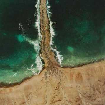
--------------------------------------------------------------------------------------------------------------------------------------------------------------------------
07 January 2010 Update (Qantara is the Red Sea Crossing Site?):
This inquiry is from a Secular Humanist and Anthropological point of view and seeks to identify the historical kernels that are behind the Exodus account which were later transformed, embellished and exaggerated by the Israelites into "miracles." The historical kernel behind an east wind blowing away a sea and exposing its dry land is understood to be "wind set down" and the _only_ east wind set down ever known to Science is the 1882 east wind blowing away the shallow waters of the east side of Lake Menzaleh (witnessed that year apparently by Tulloch and Scarth at Port Said). As noted above, wind set down cannot create a path in the midst of a sea with watery walls 7 feet high, so this claim by the Hebrews is from a rational point of view nonsense or gross embellishment, a "tall-tale". This area, Lake Menzaleh, is close to the Qantara isthmus land crossing over the Ballah inlet (today's Ballah Lakes). This isthmus was fortified by the pharaohs and perhaps the Exodus' Migdol (a Semitic word meaning "a fort") recalls one of these forts as noted by Hoffmeier. The presence of chariots, armies and a migdol in the Exodus Red Sea Crossing narrative would be "met" with the historical kernels of Egyptian forts, armies, chariots crossing the Qantara isthmus for Syria and Canaan since the days of the 18th Dynasty of Egypt. 19th Dynasty wall reliefs show Pharaoh herding foreign captives before his triumphal chariot to Egypt's border lined with forts (migdols in Semitic) and approaching a crocodile infested canal or river with a bridge over it lined on both sides with reeds (Egyptian twfy "suph") and marsh grasses, apparently derived from the Nile, this canal (?) being called in Egyptian Ta-Denit "The Dividing Water." Herodotus (ca. 440 BC) was informed by Egyptian priests that Egypt was the land inundated by the Nile, land _not_ innundated by the Nile was not Egypt. The Nile inundations in the 1840's, as shown on maps of that period extend to Ras el Ballah and the El Kraieh Marsh north of Lake et-Timsah. The Qantara land bridge is thus the crossing point of Egypt's easternmost border, the waters of the Nile, which inundate the Ballah inlet. The Ballah inlet is an extension of the eastern side of Lake Menzaleh where a strong east wind can blow away standing lake water (3 to 6 feet). Ballah may preserve Baal-zephon "Baal of the north," where Israel crossed the Yam Suph or Reed Sea. Perhaps Egypt's defeat at Yam Suph is at Qantara? If this is the site of the Red Sea Crossing, this may be a fanciful tongue-in-cheek "inversion" of the many defeated nations Syrians, Phoenicians, Philistines, Canaanites, and thousands of Apiru/Habiru that crossed Qantara to become slaves in Egypt? Did Ta-Denit "The Dividing Water" (perhaps an allusion to Egypt's border being divided by the Nile's water from the Sinai wilderness) come to be in the Israelite recasting Yahweh "dividing a sea in half" for his people to cross over to freedom, whereas the Egyptian pharaohs saw the Qantara crossing as the beginning of slavery in Egypt for conquered Apiru/Habiru (Hebrews?) who would build Egyptian treasure cities like Rameses (Pi-Rameses, Qantir/Daba)? The Nile was called in Egyptian at times iuma or "sea" and today Arabs call the Nile Bahr Nile, "Sea Nile." Did Egyptian iuma become Hebrew yam "sea," did Egyptian p3 twfy, "the sufi" (reeds) become via homophone or homonym confusion equated with Hebrew Yam Suph, "the sea of the end" (the Gulf of Aqabah near Edom, Ezion-geber and Elath being called Yam Suph)? The Arabs also call the Nile's canals or channels Bahr or "Sea," the Bahr Safieh that Zoan is on is a canal/channel emptying into Lake Menzaleh. So a shallow 3-6 feet Nile flooded marsh-lake at Qantara (Lake Menzaleh and its Ballah inlet) became associated perhaps via a homophone or homonym confusion (twfy, suphy) with the Gulf of Aqabah's (yam suph) deep waters, allowing an Egyptian army to be drowned in its depths.
Recap of 07 January 2010 (Qantara is Israel's RedSea Crossing Site?):
(1) An east wind blowing away a sea's waters is met with the 1882 east wind blowing away Lake Menzaleh's waters on its eastern side (that a lake is called a "sea" is met with the Israeli "Sea" of Galilee, a small lake, it is smaller than Lakes Menzaleh/Ballah, and the Dead "Sea" which is a lake as well).
(2) The dividing of the sea (lake) into a path of dry land is perhaps an allusion to the Qantara land bridge or ishtmus corridor and the Egyptian canal called Ta-Denit, "The Dividing Water." Crossing this dry land corridor "a sea" (a lake like the Sea of Galilee and Dead Sea) would be seen on Israel's right and left sides: to the left, Menzaleh Lake, to the right, Ballah Inlet/Lake.
(3) The presence of Egyptian chariots, horses and army _at_ the Red Sea Crossing site, along with a migdol (fort) may be an allusion to the Qantara land bridge being fortified since 18th Dynasty times and this area being the crossing point of Pharaonic armies into Asia (Syria, Canaan) to bring back slaves to build Egypt's monuments and cities.
(4) The notion that the Crossing of the Red Sea secures Israel's freedom is an inversion-allusion to Qantara being usually seen as the _beginning_ of slavery in Egypt for conquered peoples (thousands of Canaanite Apiru/Habiru/Hebrews?) herded into Egypt by Pharaonic armies and chariots, as appear on 19th Dynasty Wall Reliefs.
(5) Baal zephon, "Baal of the north" is met with the Qantara land bridge crossing over the Lake Ballah inlet, both sites being on the _north_ side of the Isthmus of Suez and forming the northeast border of Egypt's land inundated by the Nile.
(6) Hoffmeier and Kitchen have noted that the reigns of Joshua and the Judges total nearly 600 years as opposed to 480 years (1 Ki 6:1) setting the Exodus in the days of Pharaoh Ahmose I, founder of the 18th Dynasty who expelled the Hyksos (Josephus understood the Hyksos Expulsion was the Hebrew Exodus). Manetho has the Hyksos being allowed to return to Jerusalem. So the Hyksos Exodus was probably via "the way to the land of the Philistines," contra the biblical narrative, which mistakenly has the Exodus going south to the Guf of Suez.
(7) If the above observations are on the mark it follows that the Exodus, while based to some degree on a real phenomon of Nature (east wind set down at the east side of Lake Menzala near Qantara exposing a sea/lake bottom), there is a lot of fanciful and gross embellishment making this into a miracle (the physical impossibility of water being heaped up 7 feet or more like a wall on either side of Israel). I understand that the Exodus is recalling, in part, the Hyksos Expulsion of circa 1540 BC, and they would have left Egypt via Qantara for Jerusalem.
(8) Under David Jerusalem was captured. Israelites later married Jerusalem's Jebusites, whose ancestors in the days of Pharaoh Akhenaton wrote letters advising Pharaoh all of Canaan had fallen to the Apiru/Habiru, only Jerusalem had not yet fallen. Perhaps as a result of the biblically forbidden Iron Age I intermarriages, traditions of an Exodus from Egypt 600 years before Solomon's temple was erected (cf. the chronologies of the Judges compiled by Hoffmeir and Kitchen) the Late Iron Age II (7th-6th century BC) Jews preserved their Canaanite ancestors' traditions of an escape from Egypt, Pharaoh Ahmose I who expelled the Hyksos being recast into Moses (Hebrew: Moshe, Arabic: Musa) who led his people triumphantly out of Egypt? Archaeology attests to hundreds of new Iron Age I villages appearing in Jordan and Canaan in areas associated with the conquests of Moses and Joshua. Apparently this period of conquest and settlement, circa 1260-1160 BC has been merged with Jebusite (Canaanite) traditions of the Hyksos Exodus from Egypt circa 1540 BC.
(9) Events associated with Qantara in northern Egypt are being recast into a new story and transposed by the Exilic narrator to the Southern Sinai, denying an Exodus via the way to the land of the Philistines (Ex 13:17). Why? He was _unaware_ that the Philistines did not settle in Canaan before the Days of Pharaoh Rameses III (circa 1175 BC) and were not in place to prevent Israel from entering Canaan via Philista so he rerouted Israel to the southern Sinai and had her attempting to enter Canaan via the Negeb and later Transjordan. The Exodus being described in the Bible _is_ to the Southern Sinai, Negeb and Jordan. But the "real" Exodus was via the Qantara land bridge and "the way to the land of the Philistines" because there were no Philistines to oppose this Exodus until 1175 BC. This explains why, despite years of careful searches by archaeologists no sites have ever been found in the southern Sinai of Israel's campsites. The archaeologists using the Bible's itinerary were searching in (1) the wrong location (southern as opposed to northern Sinai) and (2) the wrong time period circa 1540 BC Hyksos Exodus (versus a Catholic 1512 BC, Protestant 1446 BC, Secularists 1260 BC). They did however come to correctly realize that the biblical account was fictional as the only time witnessing most (not all) of the Exodus sites being in existence and occupied was the Late Iron Age II period (the 8th-6th centuries BC) and concluded, correctly, this when the Exodus story appearing the Bible was concocted. (3) The clustering of site names like Zoan (San el Hagar), Rameses (Pi-Rameses at Qantir), Goshen (Pa-Qus, Faqus) Baal-zephon (Ballah Lakes and a Baal zephon woshipped at Defenneh, Daphne) in the northeastern delta caused archaeologists to correctly realize the Exodus events were unfolding here as opposed to Josephus' 1st century AD mistaken notion that Rameses and Goshen were at Cairo (Josephus' Letopolis and Babylon, today's Old Cairo) and the Exodus was not the Hajj Route to the port of Suez with a Red Sea crossing at Roman Clysma (the modern port of Suez) as believed in Christian traditions of the 4th/5th century AD.
--------------------------------------------------------------------------------------------------------------------------------------------------------------------------
In favor of Baal-Zephon being possibly a "mountain," "height," or conspicuous "elevation" of some sort see the following:
"Baal-Zephon:
Since another mountain called Mons Casius (Jebel Aqra on the Syrian coast) was known in earlier times as Baal-Zephon, it is consequently assumed that the southern Baal-Zephon was also called Casius."
Michael Avi-Yonah
Bibliography:
O. Eissfeldt, Baal Zaphon… (Ger., 1932); Bourdon, in: RB, 41 (1932), 541ff.; Albright, in: BASOR, 118 (1950), 17; EM, 2 (1965), 291–2; Aharoni, Land, 179; M. Dothan, in: Eretz-Israel, 9 (1969), 48–59. ADD. BIBLIOGRAPHY: H. Niehr, DDD, 152–54
Quoted from the Jewish Virtual Library
Professor Kraeling understands Baal-Zephon is mountainous promontory near a sea's edge, the Classical Mons Casius east of Pelusium. He argues that as Baal-Zephon in Phoenicia was a promontory near the Mediterranean Sea that was identified for bearings by sailors at sea, that consequently, the Exodus' Baal-Zephon was likely a mountainous peak near the Red Sea. He noted that the Egyptian Mons Casius was not a towering mountain peak like in coastal Phoenicia but instead a small "knoll" rising up out of the sand dunes west of Lake Sirbonis (the modern Sabkhat Bardawil). I note that Ras el Ballah (my Baal-Zaphon) would better fit a "knoll" description than the Syrian/Phoenician towering mountain of Mons Casius/Baal-Zephon:
"...Baal-zephon, by the sea...is the Semitic name of the God Zeus-Kasios, who had a sanctuary along this shore on a knoll that the ancient geographers always refer to as Mons Casius. This mount is probably Ras Qasrun near el Gals...The real Mons Casius and great sanctuary of the God Baal Zaphon lay in Phoenicia on the high peak south of the mouth of the Orontes River in Syria. In view of the proximity of Baal-zephon to the sea, we regard this identification of it with the place at Lake Serbonis as convincing, though some scholars would put it at Tahpanes, the place later called Daphne, for at that place there was also a sanctuary of the god Baal Zaphon, which has been excavated by Jean Cledat. In a Phoenician papyrus reference is made to the "god Baal Zaphon and all the gods of Tahpanes." But Tahpanes has its own name, while the Zeus Kasios place has none but Baal-zephon and lies by the sea. To put Baal-zephon at Daphne, furthermore, would not suit the identification of Migdol already proposed. One might more suitably put it at Pelusium, where Cledat also was able to establish the existence of a Baal Zaphon sanctuary."
(pp. 105-106. "The Theory of a Northern Crossing." Emil G. Kraeling. Rand McNally Bible Atlas. Chicago. Rand McNally & Company. 1956, 1962, 1966)
Dr. Verreth, PhD, translates Ras el Ballah to mean "Cape Ballah" or "Cape of [lake] Ballah"(cf. p. 828. Vol. 1. Herbert Verreth. The Northern Sinai From the 7th Centrury BC till the 7th Century AD, A Guide to the Sources. Leuven, Belgium. 2006). Perhaps this is the reason "why" it has been so hard for PhD scholars to identify Baal-Zephon? They, as bloodhounds had the correct scent: Baal-Zaphon being a promontory (a sort of cape) overlooking the Mediterranean Sea in Phoenicia/Syria was a clue for an Egyptian Baal-Zephon, but they apparently were unaware that a "sea cape" could exist in the midst of the arid Isthmus of Suez: "Cape Ballah," Ras el Ballah, by the Ballah inlet! Who would ever think to look for a "sea's cape" or promontory near a lake in the midst of an arid desert? The PhD scholars also had correctly figured out another puzzle piece, the Egyptian Mons Casius wasn't a towering mountian at all but instead a "small knoll" arising from the midst of sand dunes and this fits the description of Ras el Ballah, "Cape Ballah"!
Hoffmeier has rejected the notion that Baal-Zephon is a seaside mountain or knoll, for him it is the "water of Baal," zephon apparently locating it in the "north":
"This analysis of Papyrus Anastasi III 2.8-12 indicates that there may be a connection with three toponyms found in Exodus 14:2, Baal, p3-hr, and p3 twfy, all associated with bodies of water, we propose correspond to Baal-Zephon,
Pi-hahiroth and Yam suph. The fourth toponym, Migdol...was a frontier fort of the 19th and 20th Dynasties, which spanned at least from the reign of Seti I to Rameses III (ca. 1294-1153 BC)..."
(pp. 106-107. James K. Hoffmeier. Ancient Israel in Sinai, The Evidence for the Authenticity of the Wilderness Tradition. Oxford University Press. 2005)
Maps of 1797-1860 "ought be" consulted by scholars in establishing the area's topography before the construction of the Suez Canal. Regretably, they appear to have _not_ been consulted by PhD scholars writing on the subject of Israel's Red Sea crossing.
Currently, maps made by PhD scholars like the Egyptologists Manfred Bietak, Kenneth Andrew Kitchen and James K. Hoffmeier speak of this area as the Ballah "lakes." They are technically "correct" as today this area is occupied by three marsh-lakes. Professor Hoffmeier attempted to reconstruct the geography of this area in Israel's day, the 13th century BC for him, and identify in the Ballah lakes area the Israelite Red Sea Crossing (cf. James K. Hoffmeier. Israel in Egypt, the Evidence for the Authenticity of the Exodus Tradition. Oxford University Press. 1996, and his Ancient Israel in Sinai, the Evidence for the Authenticity of the Wilderness Tradition. Oxford University Press. 2005). Missing in Hoffmeier's two books on the subject of Israel's Red Sea Crossing is the 1797-1799 Napoleonic survey of this area revealing that the "Ballah Lakes" did not exist in 1797-1799, Ballah was merely "an inlet" of Lake Menzaleh. Perhaps Hoffmeier (as well as Bietak and Kitchen?) was unaware of the existence of the Napoleonic maps?
The below 1797-1799 cartographic surveys reveal that Birket Ballah drew its water from an estuary, Lake Menzaleh, the same body of water that Tulloch reported winds causing Menzaleh's waters to blow away exposing 7 miles of lake bottom. If an east wind blew over Menzaleh causing its waters to gather to the west side of the estuary this drop in water on the east side of Menzaleh might (?) cause the drainage of water from Ballah allowing Israel to cross Ballah west of Ras el Ballah.
Professor Kent (1914) did not say from which the direction the wind blew causing waters to be removed but Professor Haupt (1904) did, it was an east wind. It makes sense to me that if an east wind could blow back the shallow waters of Menzaleh these receding waters might draw northwestwards marsh water away from the Ballah inlet leaving it as an empty marsh bed for Israel's crossing. When the east wind had dissipated, the water would return to the eastside of Lake Menzaleh and the Ballah inlet would refill again, no northwest wind being needed to blow water back into the Ballah inlet.
My proposals for the sites associated with Israel's crossing of the Red Sea (Pink marker is Israel's Exodus route)
Hebrew yam= "sea," suph= "reed", "Reed Sea,"
Note reeds usually grow in fresh water not the salty water of the Mediterranean Sea. Lake Menzaleh is a freshwater lake or more correctly a river estuary. Due to the Nile's powerful discharge flow it is able to diminish the saltiness of the waters from the Mediterranean Sea, creating brackish water, which allows the growth of reeds and marsh grasses.
Pi-ha-`hiroth, pi= "mouth" ha= "of" hiroth, the "-th" might be a Hebrew word ending (?) not preserved in Arabic, perhaps even replaced by an Arabic sufformative?
Baal-zephon: zephon means "north," so Baal "of the north," is for me, Ras el Ballah.
Yam Suph, the "Sea of Reeds," is for me, the Ballah inlet, an extension of Lake Menzaleh, including the marshy Lake Karash, to the south of lake Ballah. A French map describes it as being "a salt-marsh lake called Karach."
Apparently a powerful east wind was envisioned as pushing the shallow waters of the Ballah inlet NW towards Lake Menzaleh which itself may have experienced its waters being pushed back too exposing in places its own lake bed (as remarked upon by Tulloch). Before Israel crossed over the Ballah marsh inlet (the crossing of the Reed Sea) she was apparently envisioned as camped on the west side of the Reed Sea. A track from Salhieh on the delta's east edge ends at the Ballah inlet east of Ras el Ballah, this might be the track Pharaoh would use to come upon Israel camped before Pi-ha`hiroth, in front of Baal-Zephon and Migdol. Is it possible that the Bible erred in describing the Red Sea crossing points as all being west of the Sea? Perhaps some were east of the sea? Ballah of the north (Zephon) is Ras el Ballah WEST of the crossing point, BUT, PERHAPS, Pi-ha-Hiroth and Migdol are east of the Sea as Bir Abu Erouq and Bir Abu Maktal?
Exodus 14:1-2 RSV
"...encamp in front of Pihahiroth, between Migdol and the sea, in front of Baal-zephon; you shall encamp over against it, by the sea...In front of Baal-zephon you shall encamp over against it, by the sea"
Israel's camp is east of Ras el Ballah, west of the northern opening to the El Karieh marsh (Pi-ha`Hiroth/Chiroth/Khiroth); the sea is the Ballah inlet as well as the El Karieh marsh. Migdol is Bir el Makdal on the track from Salhieh, Ras el Ballah and Bir Abou Rouq.
Exodus 14: 9
"...overtook them encamped by the sea, by Pi-ha`hiroth, in front of Baal-zephon."
The Reed Sea (Yam Suph) is the marshy Ballah inlet below and east of Ras el Ballah.
Numbers 33:7-8 RSV
"...Etham, which is at the edge of the wilderness. And they set out from Etham, and turned back to Pi-ha`hiroth, which is east of Baal-zephon; and they encamped before Migdol. And they set out from before Pi-ha`hiroth, and passed through the midst of the sea into the wilderness, and they went a three days' journey in the wilderness of Etham, and encamped at Marah..." (note: some Bible translations have Pi-ha`hiroth as "before" Baal-Zephon, so Israel could be _east_ of Baal-Zephon.
Etham is Lake Et-Timsah, on the track going south from the Ras el Ballah vicinity.."Turning back from" Etham to Pi-ha`hiroth means Israel is going due north from Lake Et-Timsah to camp east of Ras el Ballah/Baal-Zephon.
"They encamped before Migdol" means that Israel is camped on the track by Ras el Ballah (Baal-Zephon) and she "faces" meaning Bir el Makdal is east of the Ras el Ballah marsh ford crossing.
Please Click Here to access an interactive version of the below map allowing you move all over it and zoom in and zoom out of its various locations at the David Rumsey Historical Maps Archive. When the map appears on your screen move your cursor across its surface, this will cause a zooming bar to appear. Click on the + (plus sign) to activate the map's zooming bar's features; repeated clicking on the + magnifies the map, repeated clicking on the - (minus sign) decreases the magnifying effect. By placing your cursor on the map and holding down your mouse key a hand will appear allowing you to move the Map about to various sectors, right, left, up and down, with the hand symbol that your cursor arrow has become.
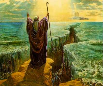
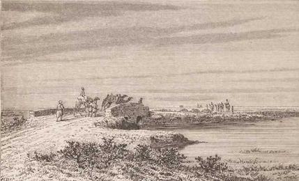
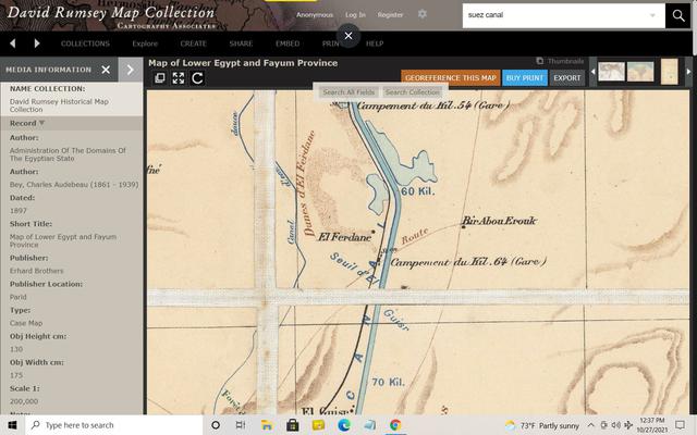
Below, Bir Abou Erouk (map of 1897) my proposal for its possibly preserving the word Pi-Ha-Hiroth of the Exodus' Red Sea Crossing. Other maps render Erouk as Rouq, Erouq, Ruk, and Uruq. Biblical Hiroth seems to be best recalled in Eroug/Erouk.