Elim of the Exodus is Ayun Musa not Wady Gharandel?
14 April 2010 (Revisions through 31 January 2020)
On 06 July 2010 Yahoo ranked this article No. One over 309,005 other urls when "Elim 12 springs" was keyed in.
Some scholars have suggested since the 1820s that Elim is to be identified with Wady Gharandal (a Red Sea crossing being envisioned at Suez). The problem? It doesn't "match" the description found in the Bible! It has trees and a small flowing brook, but to date, 2013, no one has identified Elim's 12 springs at Gharandel. If Wady Gharandel does not possess 12 springs it is an unlikely candidate for Elim for me.
Mihelic (1962) on Elim:
"Elim [large trees]. The fourth stopping place after the Israelites crossed the Red Sea, and the first place where they found fresh water. It was marked by twelve springs of water and seventy trees (Exodus 15:27; 16:1; Num 33:9-10). Elim is commonly identified with Wadi Gharandel, where vegetation, palms, and abundant water are found..."
Cited:
E. H. Palmer. The Desert of the Exodus, Journeys on Foot in the Wilderness of the Forty Years' Wanderings, Undertaken in Connection with the Ordnance Survey of Sinai and the Palestine Exploration Fund. New York.
Harper & Brothers, Publishers. 1872)
J. L. Mihelic. "Elim." p. 90. vol. 2. George A. Buttrick, editor. The Interpreter's Dictionary of the Bible, An Illustrated Encyclopedia. Nashville & New York. Abingdon Press. 1962)
Zorn (1992) on Elim:
"Elim...The second named encampment reached by the Israelites four days after crossing the Red Sea as listed in Exod 15:27-16:1 and Num 33:9-10, possibly located in the wilderness of Shur (Exod 15:22-27) or Etham (Num 33:8-9). The site was marked by twelve springs and seventy palm trees...Researchers who accept a S route for the Exodus have usually located Elim in the wadi Gharandal, about 90 km S of Suez (GP 2:210; Palmer 1872: 46, 226; Petrie 1906:205; Robinson 1856:68-69, 72-73; GTTOT, 252; WHAB, 41), where much water and vegetation was found..."
(Jeffrey R. Zorn. "Elim." p. 469. Vol. 2. David Noel Freedman. Editor. The Anchor Bible Dictionary. New York. Doubleday. 1992)
Palmer (who explored the area 1868-1869) visited Wady Gharandel and noted that several scholars had suggested it was Elim and he agreed though he did not find 12 springs, only a flowing stream:
"A little farther on, the eye is again refreshed by the sight of green tamarisks and feathery palms, and just off the customary track is a pleasant stream of running water. This is Wady Gharandel, generally regarded as Elim, and whether or no the grove and stream are the lineal descendants of the tweleve springs and seventy palm-trees which the children of Israel found there, it is clear that the site of Elim must lie somewhere in the immediate neighborhood...we halted here for the day...we made our way down to the running stream before spoken of; and, insignificant though it was, it presented a refreshing sight to eyes that had been so long accustomed to the scorching white glare of the thirsty plains."
(p. 46. E. H. Palmer. The Desert of the Exodus, Journeys on Foot in the Wilderness of the Forty Years' Wanderings. New York. Harper & Brothers, Publishers. 1872)
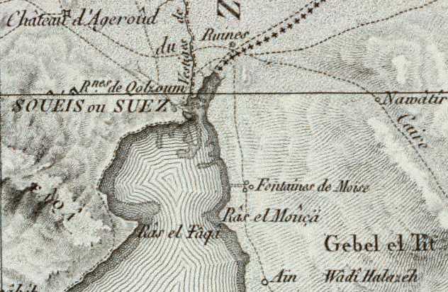
Below, a map (1938) showing Wady Gharandal with only _one well_ called el Ain in light blue and yellow marker on the north side of the wady (Map titled: Hammam Fara'un. Southern Sinai. Sheet 1. Department of Survey and Mines. 1938. Scale: 1:100,000).
I note that the Egyptologist Dr. Gregory D. Mumford PhD (Toronto University) has on-line an account of his excavations in the southern Sinai. He mentioned in passing and provided a photo of Ayun Musa at his website. What riveted my attention was his statement that Ayun Musa means "the wells of Moses" and that this oasis possesses TWELVE WELLS. http://www.deltasinai.com/sinai-01.htm
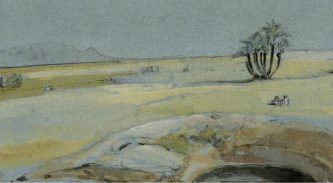
Below, a watercolor of one of the springs at "Ayun Mousa" made 12 June 1841 by the artist Edward Thomas Daniell:
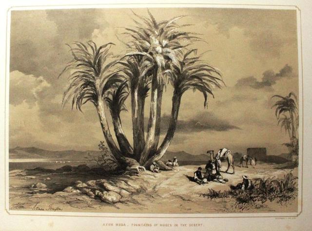
Below an engraving showing Ayun Musa by the artist David Roberts published circa 1842-1849. In the distance is the Gulf of Suez to the West of Ayun Musa (only one spring is shown in this picture). Note that this spring is _not_ lined in stone, it appears to fill a natural depression in the earth's surface.
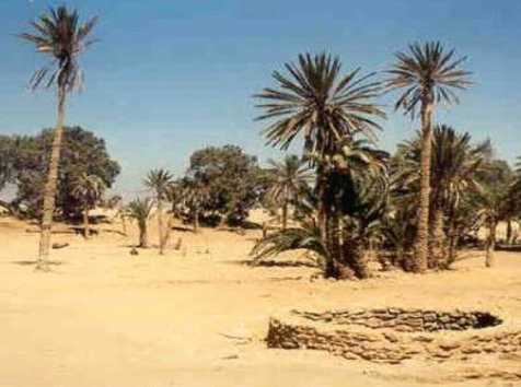
Below, a well lined in stone at Ayun Musa:
Below, some of Ayun Musa's "stunted" palm trees, goats graze under the trees in their shade:
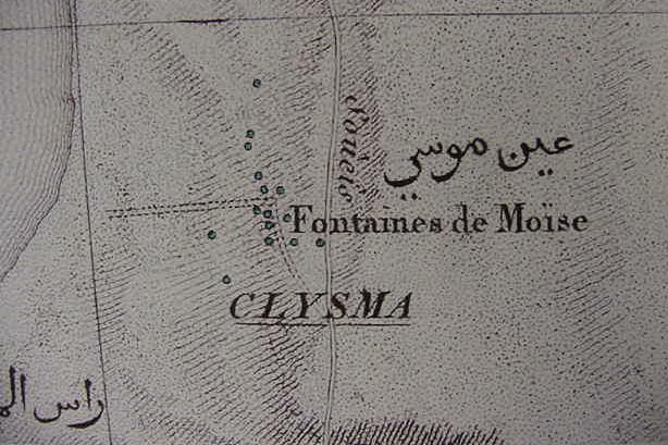
Below, Ayun Musa as the "Fontaines de Moise" published at Paris, France in 1818 by Panckoucke based on a survey of circa 1796-1798. Due to the map's "reduced scale" of 1:1,000,000 versus the preceding map's 1:100,000 only 3 of the 15 springs or fountains appear (Please click here to access the interactive version of the map at the David Rumsey Historical Maps archive. 1818. Publisher: C.L.F. Panckoucke. Carte geographique de l'Egypte et des pays environnans. Flle. 2)
Manning (1911) on Ayun Musa being Marah of the Exodus:
"Following in the track of the Israelites, we leave Suez, and in about three hours reach the Ayun Mousa, or Wells of Moses. These wells are of all shapes and sizes. Some are merely shallow pools, others are deep shafts lined with masonry. In most of them the water is bitter and acrid; in a few only is it drinkable. Aquatic plants cover the surface of the ponds, and the surrounding soil is laid out in gardens which are irrigated by sakiehs like those used in Egypt. If we adopt the theory that the passage of the Israelites through the Red Sea was at a point to the north of the present head of the Gulf, Ayun Mousa may with some probability be identified as Marah, “where they could not drink of the waters, for they were bitter.”
(p. 201. Rev. Samuel Manning. LL.D. The Land of the Pharaohs. Egypt and Sinai: Illustrated by Pen and Pencil. The Religious Tract Society. London. 1911)
Smith's Bible Dictionary (1868 edition) understands 17 wells existed at Ayun Musa, 2 more than appear on the Napoleonic survey of 1796-1798 (Smith thought Israel may have assembled at Ayun Musa after crossing over the Red Sea):
"The station of Ayun Musa (the Wells of Moses), with its tamarisks and seventeen wells may have served for their gathering after the passage."
(p. 994. "Wilderness of the Wandering." William Smith, Editor. A Dictionary of the Bible comprising its Antiquities, Biography, Geography and Natural History. Hartford, Connecticut. S. S. Scranton & Company. 1868)
There is, however, the possibility that Smith (1868) "mis-recollected" the earlier research of Robinson (1838) who stated he found 7 wells at Ayun Musa (not 17 wells):
"We reached Ayun Musa half an hour afterwards. Here I counted seven fountains, several of them mere recent excavations in the sand, in which a little brackish water was standing. Others were older and more abundant; but the water is dark-coloured and brackish, and deposits a hard substance as it rises...The Arabs call the northernmost spring sweet; but we could not perceive that it differed much from the others...about twenty stunted untrimmed palmtrees, or rather palm bushes grow round about in the arid sand."
(p. 62. Vol. 1. Edward Robinson & Eli Smith. Biblical Researches in Palestine and the adjacent regions, A journal of travels in the years 1838 and 1852. London. John Murray. 1856. 2d. edition)
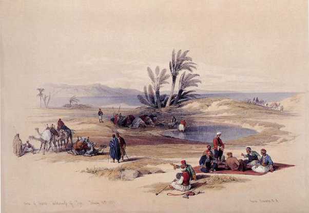
Clarke (1881) quotes the British explorer Henry Morton Stanley (?) on the 17 wells at Ayun Musa in a description accompanying a drawing showing several seated Arabs smoking pipes by a pool of water under the shade of palm trees:
"“It is a strange spot—this plot of tamarisks” (and palms) “with its seventeen wells—literally an island in the Desert, and now used as the Richmond of Suez—a comparison which chiefly serves to show what a place Suez itself must be!”—(STANLEY.)"
(p. 7. Vol. IV. C. Pickering Clarke. "Sinai." Charles Wilson. Editor. Picturesque Palestine IV: Sinai and Egypt. 4 Vols. 1881)
Wellsted (1838) counted 20 fountains or pools with clumps of palms at Ayoun Musa yet in this same year, 1838, Robinson (cf. above) counted only 7 fountains and 20 palms:
"The whole of this tract, from Howara to Ayoun Musa, is, in consequence of its being destitute of water and pasturage, in great disrepute with the Bedouins. Towards sunset we drew towards those fountains...Here we found about
twenty turbid pools, exceedingly nauseous both in taste and smell: the shipping are, however, supplied with some of the comparitively better, though still very indifferent quality, from a well a short distance to the southward of the other. Interspersed amidst these pools, there are about twenty clumps of palms, the branches of which are so thickly interwoven, that they form a dense, impervious mass, affording to the Arab, where no other can be obtained, a shelter from the piercing northerly winds which prevail here at this season."
(pp. 40-41. Vol. 2. "Tor to Suez." Lieutenant James Raymond Wellsted, F.R.S. (Indian Navy). Travels in Arabia (Sinai; Survey of the Gulf of Akabah; Coasts of Arabia and Nubia). London. John Murray. 1838)
Cook (1872) on various European travelers with conflicting counts of 7, 17 and 19 wells at Ayoun Musa, noting more may exist:
"The station where Moses and his people halted to celebrate their deliverance is generally admitted to be Ayoun Musa, i.e., the fountains of Moses. It is the only green spot near the passage over the Red Sea. There are several wells there
(17 according to Dr. Stanley, p. 67, 7 according to Robinson, p. 62). Tischendorf, whose description is fuller than that of other travelers and gives a more pleasing impression, counted 19 and observes that the vegetation indicates a still larger number. 'Aus heiligen Land,' p. 22. The water, like all the water on the western coast of the Peninsula, is dark-coloured and brackish, but it is drinkable..."
(p. 313. Note 22. Frederick Charles Cook. The Holy Bible According to the Authorized Version of 1611 With an Explanatory and Critical Commentary. Vol. 1. Part 1, Genesis & Exodus. New York. Scribner, Armstrong & Company. 1872)
Tischendorf in 1853 counted 19 wells at Ayun Musa, suggested more probably existed and cited a 1483 account of a camel found near 3 springs (drei brunnen) which were hot springs (brunnen heissen) at Ayun Musa:
"Fruhere reisende haben deren bald mehy, bald weniger gezahlt. 1853 zahlte ich selber 19; aber noch an vielen andern stellen verriethen schilfrohrbuschel, dass die nachspurende hand wasser finden wurde. Im jahre 1483 schrieb Fabri daron: "Wir funden die kamel in einem weiten sandfelde bei drey brunnen, die im sande da entspringen. Da hat man abgeladen, und tranket das viehe. Das wasser war ein wenig gesalzen und so warm als ware es bei dem feuer gestanden, darum wir sein nicht mochten trinken. Die brunnen heissen Moyses-brunnen, weil er mit den kindern von Israhel auch da gelegen ist den brunnen."
(p. 23, note 1. Constantin Tischendorf. Aus dem heiligen Lande. Leipzig. F. A. Brockhaus. 1862)
Click here to access this book on the internet.
Wilson (1846) counted "7 brackish puddles" at Ayoun Musa:
"Early in the morning of our last day at Suez, Omar appears with horses and provisions, for a ride round the gulf to Ayoun Musa, or the Wells of Moses, and we cross by the ford at low water...The seven sandy pits with their
seven muddy, brackish puddles, at which we arrived about noon, scarcely deserve the prosaic name of wells, much less the sparkling poetry of such a word as fountain...However, there is water...No special mention is made of these springs in the Mosaic record, but there is little doubt that as they are now, so they were then; therefore in all probability the host of Israel made their first halt at Ayoun Musa in the wilderness of Shur, and then went three days and found no water till they came to Marah," a station about thirty miles further south still known for the bitterness of the spring...The description of Elim in the Exodus itinerary, might apply almost as well to Ayoun Musa, though distant four or five days' march."
(pp. 201-202. Thomas Wilson. Nozrani in Egypt and Syria. London. Longman, Brown, Green & Longmans. 1846)
Rosenmuller (1841) apparently counted five fountains at Ayoun Musa:
"About eight or ten miles south of the point opposite Suez, on the east side of the Red Sea, the traveller comes to Ayoun Musa or Fountains of Moses. Niebuhr says "water is found here, in different places, on digging holes a foot deep in the ground; and the so-called Wells of Moses, of which I counted five, were not deeper than this. They were not stoned at all, and became immediately full of sand and dirt, so soon as one attempts to draw water from them...As these wells bear the name of Moses, the Arabs believe it was at this point the Israelites crossed the Red Sea."
(pp. 270-271. E. F. C. Rosenmuller. Professor at Leipzig University. [translated from German]. The Biblical Geography of Asia Minor, Phoenicia, and Arabia. Edinburgh. Thomas Clark. 1841)
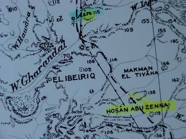
A book reviewer in 1857 notes that a Sinai explorer called Dr. Stewart argued that a well called Ain Nichele is Marah (it lies near Gebel Amarah, N of Wadi Gharandal) is "one day's march" from Wadi Gharandel, a distance of 12 1/2 miles:
"The well of Nichele not only corresponds he argues, in point of time and distance, with the scripture narrative, supposing Ayun Musa to have been the place where the Israelites crossed, but it is situated exactly one day's march of 12 1/2 miles from Wadi Gherundel, usually believed to be the Elim of scripture...the wells, it is true, have diminished in number, but a stream runs through the valley..."
(p. 647. Vol. 203. "Historical and Miscellaneous Reviews." Edmund Burke. The Gentleman's Magazine. London. James Nisbet. 1857)
The "importance" here, for me, is the statement that one day's journey is approximately 12 1/2 miles. If Dr. Stewart is correct that a day's journey is roughly 12 1/2 miles and if Elim is Ayun Musa then one day's journey north of Ayun Musa should be Marah, the previous encampment. This places Marah in the vicinity of the southern part of the Little Bitter Lake: al-Buhayrah al-Murrat as-Sughra. The Arabic word for bitter being murrat. I note that the Septuaginta Bible written in Greek by Jews for Jews at Alexandria, Egypt circa 275 BC renders Marah as Merra, the two "rr's" seem to be preserved in modern Arabic. Perhaps the waters of Marah Hebrew mayim Marah is recalling the two bitter lakes, the large bitter lake being called al-Buhayrah al-Murrat al-Kubra? Mayim can be understood to be a plural with its "-im" sufformative. Three days north of Marah would be the crossing of Yam Suph or the "reed sea" according to some scholars. 60 kilometers or 36 miles (3 days) north of al-Murrat as-Sughra puts the "reed sea" crossing just north of Lake Timsah in the vicinity of Ras el-Ballah el Moyeh, called incorrectly Lake Ballah by some, it was originally an inlet or arm of Lake Manzeleh according to maps made before 1860. Please click here for my article on Ras el Ballah and the Ballah inlet possibly being the Red Sea Crossing point.
There are some "problems" in calculating a day's march: Bartlett who explored this area in the 19th century AD stated he had been almost 10 hours in the saddle of his camel when they camped for the night at Wady Gharandal, making camp at 7 in the evening. This suggests he began the journey about 9 in the morning. He stated the journey began at Wady Sudr to the S of Ayun Musa. A camel's pace is reckoned at 2 1/2 miles an hour. The 19th century European explorers "clocked" the time to their various destinations. By multiplying the camel's pace by the hours we can come up with a rough distance covered. Thus 10 hours to Gharandal suggests a distance of 25 miles was covered from 9 AM to 7 PM, "a day's march" would then be 25 miles. If Elim is Ayun Musa then a day's march to the preceding Israelite camp at Marah would be 25 miles north of Ayun Musa/Elim placing Marah in the vicinity of the Bitter Lakes which in Arabic are called Murrat (murrat in Arabic means "bitter"). In the 19th century before the Suez Canal was built in 1869, these lakes were, according to maps made between 1800-1860, salt-marsh depressions in the earth, their saltiness accounting for why they were called murrah or "bitter."
Bartlett on the camel's pace (14 camels were in his caravan):
"...the ordinary pace...the speed scarcely varied from two miles and three quarters per hour. By constant pushing, we could bring it up to three miles, while the loaded camels, especially where the track was rough or uneven, varied little from two and a half miles per hour. This rate they would maintain, if need be, uninterruptedly from morning to night. It became our custom -at least till after we reached Nukhl- to ride forward while the beasts of burden were loading and nearly loaded, to rest for lunch an hour or more at noon, and then overtake the caravan just as out tents were pitched at night."
(p. 191.)
Bartlett understood Israel crossed the Red Sea just north of the port of Suez at the head of the Gulf of Suez and assembled after the crossing at Ayun Musa. At 15/16 hours camel's travel time this works out to about 40 miles (closer to 47 miles); if the wilderness of Etham/Shur is a 3 day crossing between Ayun Musa and Ain Hawwarah this works out to about 18 miles a day for Israel to get from Ayun Musa to Ain Hawarah and Gharandel (Gharandel is 2 hrs S of Hawarah).
"The distance, given by Burckhardt, Ebers, and Laval as fifteen and a fourth hours, by Robinson sixteen and a half, found by ourselves and Graul sixteen hours and by Tisschendorf fifteen or sixteen hours, would be a good "three days" march to a cumbered host like the Israelites; and a suitable site for Elim is also found in due time."
(p. 198. Note 8. Bartlett)
Scholars tend to favor Marah as being ain Hawwarah citing its bitter water, having Israel's next stop as Wadi Gharandal which they identify as Elim.
The problem?
If, as most scholars suggest, each Israelite encampment is a day's march, how did a "two hour camel ride" from Ain el Hawwarah "morph" into a day's journey to Elim/Wadi Gharandel? The distance is simply _too short_, it makes no sense:
"...in one hour fiftyfive minutes from Ain Hawwarah we entered Wady Gharandel...We followed the wady toward the sea...till, in a little circle of trees and shrubs, we found out tents nearly ready..."
(p. 203. Samuel Colcord Bartlett. From Egypt to Palestine through Sinai the wildermess and the South Country. New York. Harper & Brothers, Publishers. 1879)
Conclusions:
Wady Gharandel fails to meet _all_ the criteria for Elim:
(1) The distance between a Marah at Ain el Hawwara (Hawarah) and an Elim at Wady Gharandel is too short: only two hours by camel, not constituting by any stretch of the imagination a "day's march" between encampments for Israel.
(2) While Wady Gharandel does possess an abundance of trees it doesn't possess 12 springs (wells, fountains) as was conceded by all 19th century European explorers; it has a stream or brook as noted by Palmer who visited the site in 1868, and according to Laborde (1838) a few wells among the trees, but _not_ 12 wells/springs/fountains.
(3) Ayun Musa's 15 fountains or springs (1826 Map [surveyed 1796-1798]) is a "better candidate" for Elim if we allow that the Israelites might have "overlooked" three of the artesian springs (wells/fountains) and in error counted only 12 springs? Ayun Musa also has "many trees" as can be seen in the above photos qualifying it for the "70 trees" associated with Elim.
(4) If 12 1/2 or 25 miles (a camel caravan's rate of travel: 5 hrs. or 10 hrs.) is allowed as a "possible" day's march, then Marah at the bitter lakes called Murrah or Murrat in Arabic north of Elim/Ayun Musa makes better sense for me.
Napoleon Bonoparte's Cartographers apparently conducted the most exhaustive survey of Ayun Musa and vicinity as they counted 15 springs or fountains circa 1796-1798; in 1838 Robinson found 7 springs while in that year Wellsted noted 20 fountains or pools; Laborde (1838) did not state how many springs existed at Ayun Musa; geologists Moon and Sadek in 1921 identified 12 springs; LaMoreaux in 1953 said "at least a dozen springs existed" while Mumford in 2002 stated there were 12 springs.
Professor Menashe Har-El of Tel Aviv University (1968) is probably right, Ayun Musa is most likely Elim [Hebrew elim means "trees"] of the Exodus narratives.
Har-El (1968/1983) on "why" Elim is 'Ayun Musa, it has 12 springs and palm trees (Emphasis mine):
"In Exodus 15:27, the encampment of Elim is mentioned: "And they came to Elim, where were twelve springs of water and three score and ten palm trees, and they encamped there by the waters." It is also mentioned in Numbers 33:9, Bartlett says that at 'Ayun Musa there is a spring and nine wells and a plantation extending over half a mile including palms, pomegranates, vegetables, cereals and tamarisk trees. Barron states that 'Ayun Musa has twelve sources of water, and the waters of the springs are used to irrigate gardens the fruits of which are sold in Suez. The well water is used for the camels, and there are also date palms and tamarisks. There is no other place among the encampments of the Israelites in the wilderness described as vividly as Elim, which in our opinion should be identified with 'Ayun Musa, as twelve water springs and seventy date-palms were found. The existence of twelve springs and a palm-grove at 'Ayun Musa provides clear-cut evidence that 'Ayun Musa, which lies 12 km. from Bir-el-Murrah, is in fact Elim."
(pp. 355-356. "Marah and Elim." Menashe Har-El. The Sinai Jorneys, The Route of the Exodus. San Diego, California. Ridgefield Publishing Company [ first published in Hebrew by Am-Oved Publshing Ltd., Tel-Aviv 1968])
Har-El's Barron citation: p. 37. T. Barron. The Topography and Geology of the Peninsula of Sinai (Western Portion). Cairo. Egypt Survey Department. 1907.
Barron (1907) on 'Ayun Musa and its dozen springs (note: He appears to use the words springs and wells interchangeably):
"'Ayun Musa -Just before these wells are reached the ridges disappear, and the road enters a plain which is covered with shell-sand and fragments of various things meet with on a beach. To the east of the wells is a low bank of oysters embedded in a mass of loosely cemented grit, while round about the springs the same sort of rock persists. The wells are in fact on a raised beach area. They are situated in an indentation in the low plataeu which lies around it and practically shuts it off from view from the south.
These springs are situated on a slight rise which falls sharply on its seaward side. It consists of what appears to be gritty material of the beach deposits evidently cemented together by lime deposited from the water. This rise is about three kilometres from the sea-coast and about fifteen from Suez. There are about a dozen springs of various kinds rising up through the rock, some of which are enclosed by a roughly-built wall, while others rise in natural basins evidently of their own formation, resembling a miniature cone and crater, some of which are full of rushes, while others have a clean basin. Some of the springs are utilised for irrigating the large gardens which have been planted, in which, vegetables and fruit are grown for sale in Suez. Besides these springs there are a few waterholes which are only used for watering camels, or washing purposes. Numerous palms and tarfa trees grow luxuriantly in the damp soil on the north side of the springs, forming a very efficient shelter from the wind and sun. Close to the gardens are one or two Arab houses occupied by gardeners..."
(pp. 36-37. Thomas Barron. The Topography and Geology of the Peninsula of Sinai (Western Portion). Cairo. Egypt Survey Department. 1907. Click here to access this book on the internet)
Har-El noted that W. H. Bartlett (1849) had identified 9 wells wells at 'Ayun Musa:
"Bartlett describes 'Ayun Musa...There were nine wells at 'Ayun Musa, one of which had a wheel for drawing up the water."
(p. 196. Har-El citing William Henry Bartlett. Forty Days in the Desert on the track of the Israelites. London. 1849)
Har-El noted that Robinson found 7 wells at 'Ayun Musa:
"A 'Ayun Musa, Robinson observed seven springs that flowed only a little way before vanishing into the sand, as well as twenty palm-trees..."
(p. 180. Har-El citing Edward Robinson. Biblical Researches in Palestine, Mount Sinai and Arabia Petraea. London. 1838)
Professor Hoffmeier (2005:162) accepted Har-El's (1968) proposal that Marah was Bir el-Mura east of the port of Suez but rejected his proposal that Elim was 'Ayun Musa (2005:163). Why? Hoffmeier noted that the distance between the two sites is 12 kilometers or 7 miles and this distance doesn't constitute a day's journey for Israel which he reckons to be roughly 15 miles (2005:120), scroll down for his comments:
"The problem with equating 'Ain Hawara with Marah is that it only works if the sea crossing took place near Suez. Moreover, Burkhardt, Robinson, and others suggested that nearby Wadi Gharandel is Elim, the next stop on the itinerary. Burkhardt traveled from 'Ain Hawara to Wadi Gharandel in three hours, whereas Robinson made it in just two and a half hours. This short distance means either that 'Ain Hawara cannot be Marah or Wadi Gharandel cannot be Elim, as there was no reason to camp at Marah with its bitter water when Gharandel (Elim) lies only a few hours away and the water was good. This short distance can hardly be construed as a day's journey...Alternately, some more recent scholars, such as Manashe Har-el and George Kelm, propose Bir el-Mura as biblical Marah. The Arabic name murr is cognate with Herbrew Marah, and means bitter...a connection between the site named in Exodus 15:23 and the present day Bir el-Mura is certainly plausible, and it would fit within the distance of a three days' journey or approximately ninety-six kilometers/sixty miles from our proposed crossing point on the south side of the el-Balah Lake (figure 1)...Manashe Har-el...has proposed that `Ayun Musa is Elim, largely because he needs to place it after Bir el-Mura (his Marah), which is only twelve kilometers (seven miles) away...Har-el's theory, in my opinion, fails on several points. First, Bir el Mura and 'Ayun Musa are too close to each other to stand a day's journey apart."
(pp. 162-163. "Marah and Elim." James K. Hoffmeier. Ancient Israel in Sinai, The Evidence for the Authenticity of the Wilderness Tradition. Oxford & New York. Oxford University Press. 2005)
It needs to be pointed out here that Professors Har-El and Hoffmeier _disagree_ over the rate of daily travel for Israel in the Exodus. Har-El was once a professional shepherd and based on firsthand knowledge he claims sheep cannot be driven more than 6 to 8 miles a day or they and their young will collapse of exhaustion. He notes that when Israel left Egypt she drove before her flocks of sheep and herds of cattle (Ex 12:38; cf. Har-El pp. 167 & 195):
"Herds with their young cannot cover such long distances without collapsing on the way (I know this from my own experience as a shepherd); Such a large mass of people, weighed down by large quantities of baggage and heavily laden with possessions, could not possibly have made such rapid progress. Conder's observation that the Bedouin who move camp travel at a maximum of 6 miles a day also provides support to this point of criticism. His estimate refers to small groups of Bedouin who are properly prepared for their move, in contrast to the large numbers of the Israelites who left Egypt in a hurry, without having made preparations for their journey...It must be remembered that with women, old people and children, progress under desert conditions could not have been more than 6-8 miles per day, otherwise both the women, old people and children, as well as livestock, would have been lost."
Hoffmeier, on the other hand, does not bring this subject up, he ignores it! Yes, he has read Har-El's arguments (as he cites other data from Har-El), but to accept Har-El's proposal that Israel cannot exceed 6-8 miles a day is the "kiss of death" for Hoffmeier's proposal that Israel's rate of travel was 16-23 miles a day, that of a donkey or camel caravan. Why is this a "kiss of death" for Hoffmeier? He has Israel crossing Yam Suph (the Red Sea) at Lake Ballah. The 3 days in the wilderness of Shur/Etham for Hoffmeier is the wilderness east of Wadi Tumilat and Lake Timsah. Hoffmeier _cannot_ get Israel to Bir el-Mura in 3 days from Lake Ballah at 8 miles a day he having accepted Har-El's proposal that Bir el-Mura is Marah.
Hoffmeier:
"...Beitzel....one day's journey...incorporated between 17 and 23 miles....camel and donkey caravans, which travel between 16 and 23 miles...This means that if a day's journey is based on the distance traveled by a caravan, then it also represents a distance that humans could cover in a day of walking." (Hoffmeier. 2005:120)
Hoffmeier does acknowledge that herds would necessitate a slower rate of travel, but dismisses this, claiming the Bible's daily rate of travel is not based on herds but on caravan travel and he employs the caravan mileage in his site proposals (Hoffmeier. 2005:120):
"Given the fact that they were traveling with flocks and herds (Exod. 12:38), one might expect a slower pace. Nevertheless, this factor does not change what the Bible meant by a day's journey. For the purpose of our investigation, the distances represented by a day's journey, or between campsites, provide us with valuable information for establishing plausible locations for some of the toponyms mentioned in the itinerary. If we allow for a minimum of one day's travel between campsites, and assign 24 kilometers (15 miles), a rather low figure on the basis of the above-mentioned studies, this would suggest that the trek from Rameses to Pi-hahiroth and Migdol, which is by the sea of Reeds...is about 72 kilometers (45 miles)..." (Hoffmeier. 2005:120)
Hoffmeier has a serious problem having proposed that Israel's daily rate of travel is 15 miles (24 kilometers) a day. The problem? He has accepted Har-El's proposal that Bir el Mura east of the port of Suez is Marah (2005:162). At 15 miles a day times 3 days to get to Marah from the Red Sea crossing the distance traveled would be roughly 45 miles. "As the crow flies" the distance between Lake Ballah where Hoffmeier proposes Israel crossed Yam Suph (2005:) is over 70 miles to Bir el Mura (Bir el Murr). Israel would have to travel with her herds of cattle and flocks of sheep at a daily rate of over 23 miles a day, and Har-El avers from his shepherding experience the daily rate shouldn't exceed 6 to 10 miles! So, using Hoffmeier's own data, 15 miles a day for Israel, he _cannot_ get Israel from Lake Ballah (his Yam Suph) to Bir el Murr (his Marah) in 3 days! Only if Israel travels at the _maximium_ rate of a camel caravan, 23 miles a day, can Hoffmeier get Israel from Ballah to Bir el Murr (or 20 miles a day as below proposed for a distance of 60 miles).
Hoffmeier on the distance between Lake Ballah and Bir el Murr being approximately 60 miles (I reckon it to be closer to 70 miles):
"...recent scholars, such as Manashe Har-el and George Kelm, propose Bir-el-Mura as Biblical Marah...Bir-el-Mura is certainly plausible, and it would fit within the distance of a three days journey or approximately ninety-six kilometers/sixty miles from our proposed crossing point on the south side of the el-Balah Lake (figure 1)."
(Hoffmeier. 2005:162)
Jonathan Novak (February 2010):
"The United Nations Food and Agriculture Organization (FAO) website on Bedouin flock management and Awassi sheep care says that: "While 16 km ( 9.94 miles) is considered to be a fair rate of progress when migrating to more distant pastures, if pressed, flocks may be driven for as much as 35 km (21.75 miles) in 24 hours (Williamson, 1949)...Therefore 21 miles (33.8 km) per day was a doable daily rate of travel for the escaping Exodus slaves and flocks if God provided ideal conditions for them to travel by day and at least part of the night."
(Click here for Novak's article)
Other scholars have noted that a day's march for the Roman Army was 20 kilometers (12 miles). There would be baggage animals and perhaps oxcarts accompanying the Army, but probably not herds of cattle, sheep and goats like Israel in her Exodus. If an Army's average daily rate of travel is 12 miles, is this Israel's rate of travel too?
"This corresponds roughly to the marching practices of the Roman army, for which the normal march (iter justum) was c. 20 km..."
(p. 467. Vol. 7. Erich Ebeling, Bruno Meissner, et. al. Reallexikon der Assyriologie und Vorderasiatischen Archaologie. Berlin & New York. Walter de Gruyter Publishing House. 1987-1990. A 16 Volume work)
What's my take on Har-El and Hoffmeier as regards Israel's daily rate of travel?
I understand Har-El is probably correct, 6-8 miles a day would most likely be the daily rate of travel imposed on Israel by her flocks and herds.
I agree with Hoffmeier that the biblical narrator probably gave no serious thought regarding the daily rate of travel that herds would impose on Israel; he probably used a "rule-of-thumb" notion that a caravan group can cover 16-23 miles a day depending on terrain and how heavily laden the beasts of burden are, be they donkeys or camels. In other words "unrealistic distances" (16-23 miles a day) are behind the Exodus' itinerary route. The flocks and herds would not allow Israel to cover the distances neccessary for the toponyms which have been proposed by various scholars for Israel's campsites.
I agree with Hoffmeier about 'Ain Hawara and Wadi Gharandal being too close to each other (a 2 hour camel ride or 7 miles) to be Marah and Elim. I _disagree_ with Hoffmeier and Har-El about Bir el-Mura being Marah, and _agree_ with Har-El that Elim is 'Ayun Musa.
Not mentioned by Hoffmeier is Har-El's statement citing Barron (1907) that 12 springs exist at Ayun Musa with palm trees, noting Elim has 12 springs and palm trees too, he cites only Robinson's observation about 7 springs!
Why does Hoffmeier agree with Har-El about Bir el-Mura being Marah? He posits the crossing of Yam Suph (the Red Sea) as at Lake Ballah (which he also renders as Balah) which lies 60 miles north of Bir el-Mura and he proposes that a day's journey for Israel is roughly 20 miles. As Ayun Musa is not 20 miles south of Bir el-Mura it cannot be Elim for Hoffmeier!
If we take Hoffmeier's proposed 20 miles a day rate of travel for Israel (based on camel caravans according to Hoffmeier) and seek out a site _north_ of Ayun Musa's 12/15/17 springs/wells (Elim?) we are in the vicinity of the east side of the Little Bitter Lake, Arabic: Buheirat Murrat el Sughra, the Great Bitter Lake being called Buheirat Murrat el Kubra. Murrat in Arabic means bitter. I have proposed that "the waters of Marah" famed for their bitterness are in fact these two bitter lakes.
A problem not noted by Hoffmeier or Har-El regarding Bir el-Mura being Marah is that the biblical text speaks not of the _water_ of Marah, but "the _waters_ of Marah," that "THEY were bitter," not that "it was bitter" and Bir el-Mura is only one well, failing to qualify as "the waters" of Marah. The TWO bitter lakes, for me, do qualify for the "waters" of Marah.
Hoffmeier does not propose a site for Elim (2005:162-163). To the degree that he has accepted Har-El's notion that Bir el-Murah is Marah (2005:162) and that Israel's daily rate of travel is approximately 20 miles a day (2005:162) I have set my calipers to 20 miles from Bir el-Mura and at this distance we are just north of Ras el Sudr and the vicinity of Wadi Sudr. From Sudr to Wadi Gharandal is another 25 miles. So from Bir el-Mura to Wadi Gharandal it is roughly 45 miles. Perhaps this is "why" Hoffmeier avoids proposing a site for Elim he having agreed with Har-El that Bir el-Murah is Marah? There are no 12 springs and 70 palm trees at Wadi Sudr.
Ewald (1869) understood that 40 springs existed at Ain Musa:
"If the words in Ex. xv. 22, 'they went three days in the desert and found no water' are to be taken quite literally, the encampment after the passage of the Red Sea must have been near the place now called 'Ayun Musa, i.e. 'Wells of Moses' (see p. 73), where forty springs are found..." (p. 99. Heinrich Ewald. The History of Israel, The History of Moses and the Theocracy. London. Longmans, Green & Co. 1869. Volume 2. Translated from German)
To sum all this up, the earliest European description of 'Ayun Musa is the 15 fountains or springs identified by Napoleon's French Army Corps of Engineers circa 1798-1799. Later 19th and 20th century European visitors came up with differing counts for 'Ayun Musa's wells/springs/fountains/pools: 5, 7, 8, 9, 11, 12, 15, 17, 19, 20, and 40.
My "contribution" to this research on Elim is the finding of the Napoleonic map showing that 'Ayun Musa possessed 15 springs (French: "fountains") circa 1798 making it a candidate for Elim's 12 springs; 12 springs not existing at Wadi Gharandal which is currently the scholarly conensus' candidate.
Having established that the _only_ site possessing 12 springs and palm trees between Rameses (Qantir?) and Mount Sinai (Gebel Musa at Saint Catherine's Monastery?) is 'Ayun Musa, will archaeologists ever find the remains of Moses' Israelite camp here?
The answer is NO!
Archaeologists will _never_ find the remains of _any_ Israelite camp at Ayun Musa nor any other site in the southern Sinai despite this clearly being the area Israel was trekking through according to the Bible's itinerary!
Why?
The Exodus as presented in the Bible is fiction, it never happened. It is based in part on a real event however, the expulsion of the Hyksos from Egypt circa 1540 BC by Pharaoh Ahmose I founder of the 18th Dynasty.
The Hyksos as part of their surrender terms were allowed to leave their fortress at Avaris (Rameses/Qantir) according to Manetho (a 3rd century BC Egyptian priest and historian) and return to Jerusalem. As contemporary 12th century BC Egyptian hieroglyphic records note, the Philistines did not settle in coastal Canaan until the days of Pharaoh Rameses III circa 1175 BC so they would not be in place to deny Israel's crossing their land to get to Jerusalem. This fact the Pentateuchal narrator and his audience were unaware of as he has Abraham in the Negeb at Beersheba circa 2100 BC contending with Philistines (Ge 21:25-34). He thought, in error, the Philistines would never allow Israel to cross their lands to get to Jerusalem so he routed Israel to the southern Sinai out of fear of engaging the Philistines in war (Ex 13:17).
The Hyksos would have fled to Jerusalem via the Qantara Caravan crossing at Lake Ballah called in Egyptian "the way of Heru or Hor" (Horus in Greek) using the "way to the land of the Philistines" which the Bible says Israel did _not_ use (Ex 13:17-18).
Please click here for my reasons why the Hyksos expulsion of circa 1540 BC is what is behind the fictional Exodus account appearing in the Bible.
Some Conservative devout bible-believing scholars understand the Exodus was 1519 BC (some Catholics), 1446 BC (some Protestants), 1260 BC (some Liberal scholars); archaeology reveals that the Philistines were not in place to prevent Israel from crossing their land during any of these dates. Only if Israel's Exodus is after 1175 BC could they be blocked by Philistines (known to Rameses III as the Pelest).
So, then, the day will _never_ come when an Israelite campsite will be found along a track heading ESE from the Egyptian Delta to Mt. Sinai/Gebel Musa as the account is _fiction_, a later recasting of the Hyksos expulsion of circa 1540 BC.
Liberal scholars have determined that Moses did not write the Pentateuch. The proof? They have excavated sites mentioned in the Pentateuch (Bozrah of Ge 36:33) which did not come into existence before the 8th century BC and Moses writing the Exodus account circa 1519 BC, 1446 BC, 1260 BC, 1175 BC would have no knowledge of a site that did not exist before the 8th century BC!
The Pentateuch (the first 5 books of the Bible) has 600,000 armed Israelite men (Ex 12:37) leaving Rameses for the Exodus, adding to this group wives, children, and grandparents, roughly 2 million souls left Egypt according to some scholars. The problem? European explorers of the Sinai in the 19th century AD quickly came to realize that the region's springs and wells were incapable of providing the copious amounts of water that would be needed to support a horde of 2 million, plus their herds of goats, sheep and cattle. Geologists have determined that the climate in the Sinai has not changed over the past 5000 years, the Exodus being 3500 years ago means the conditions today existed then. The account is fiction as Liberal scholars came to realize. Of course the bible-believing devout deny all these geological and archaeological findings and still cling to the belief that the Exodus account is true, claiming that the geologists and archaeologists have misunderstood the physical evidence found in the Sinai, Negev, Arabah and Moab, areas Israel crossed in the Exodus account.
This research suggests that there is only _one site_ that can accomodate Elim's 12 wells or springs and 70 palm trees and that is Ayun Musa with its 20 springs or wells (Wellsted in 1838 counting 20 pools at this location).
"IF" Ayun Musa's 12 springs is Elim's 12 springs then the preceding Israelite camp, Marah, would be one day's march away. The crossing of the Red Sea (Hebrew: Yam Suph) would be an additional 3 days away via the wilderness of Shur/Etham for a total of 4 days from the sea's crossing to the arrival at Elim. Because Ayun Musa is so close to the Gulf of Suez and so near the port of Suez (14 miles), it is unlikely that it would take Israel 4 days to get to Elim/Ayun Musa after crossing the Red Sea near the port of Suez. The crossing is probably much further away than Suez.
The siting of the Red Sea crossing depends on Israel's daily rate of travel which, regretably, is _not_ agreed upon by scholars (various proposals being from 6 to 25 miles a day).
How is it that scholars overlooked for so long Ayoun Musa being Elim, that is, until, in 1968, the Israeli Professor Menashe Har-El at Tel Aviv University made the connection based on its 12 springs and palm trees described in 1907 by the geologist Barron?
Its an interesting story. Apparently by the 4th/5th century AD Christian holymen who frequented the Sinai came to associate the crossing of the Red Sea by Israel with the shoals about Roman Clysma, a fort erected by the Roman Emperor Trajan circa the 2d century AD to control maritime ship traffic on the Red Sea canal to Egypt via the Bitter Lakes and Wadi Tumilat. A French or Spanish Pilgrimess (circa 4/5th century AD) called either Egeria or Etheria stated her holymen guides fixed the crossing at Clysma's shoals.
Bible scholars (with a few notable exceptions) of the 19th century AD tended to believe that the Red Sea crossing was near Clysma (later supplanted by the Arabic port of Suez) and accordingly thought a 3 day trek across the wilderness of Shur/Etham to Marah meant wherever Marah was it was that distance from Suez/Clysma. As Elim follows Marah, it made sense to them to suggest Marah was Ain Howara and Elim was Wadi Gharandal. Travelers by camel, using watches to clock their travel times, posited that the distance from Ayoun Mousa to Howara was Israel's 3 day march across the wilderness of Shur/Etham. As Wadi Gharandal possessed a brook or rivlet of water and palms it became Elim dispite the fact it was only 2 hours by camel from Howara/Marah.
In other words, the 19th century scholars turned a blind eye to the data they had assembled in order to hold on to the Romano-Christian traditions (4th-5th century AD) of a Red Sea Crossing at Suez/Clysma.
The anomalies which they ignored?
(1) Howara/Marah is a 2 hour camel ride to Gharandal/Elim, its a stretch of the imagination to assume it took Israel a whole day to cover this distance.
(2) Gharandal/Elim doesn't have 12 wells or springs, only a small brook and a few wells.
(3) Ayun Musa was for them where Israel assembled after crossing the Red Sea near Clysma/Suez, as it is just a few miles away and within view of the Gulf of Suez. Here they had Miriam, Moses' sister singing a victory song praising God for destroying Pharaoh in the sea. It simply would not do to have Ayoun Musa being Elim as it was too close to the Red Sea Crossing! They needed 4 days to get from the Red Sea to Marah and Elim. Manning (1911) said he reached Ayoun Musa in three hours from Suez.
McClintoch (1883) rejected the local Arab traditions that Ayoun Musa is Marah because of its brackish waters and palm trees:
"Marah...The Ayoun Mousa, 'wells of Moses,' which local tradition assigns to Marah, are manifestly too close to the head of the gulf, and probable spot of crossing it to suit the distance of 'three days' journey.'"
("Marah." p. 730. vol. 5. John McClintock & James Strong. Cyclopaedia of Biblical, Theological, and Ecclesiastical Literature. New York. Harper & Brothers. 1883)
Calmet (1832) on the 3 days trek across the wilderness of Shur/Etham being Ayoun Musa to Howara:
"From Ayoun Musa to the well of Howara we had traveled fifteen hours and a quarter. Referring to this distance, it appears probable that this is the desert of three days mentioned in the Scriptures to have been crossed by the Israelites after their passing the Red sea; and at the end of which they arrived at Marah. This is the usual route to mount Sinai, and was probably, therefore, that which the Israelites took on their escape from Egypt, provided it be admitted that they crossed the sea at Suez, as Niebuhr, with good reason, conjectures. There is no other road of three days' march in the way from Suez towards Sinai, nor is there any other well so absolutely bitter on the whole of this coast."
(p. 410. "Exodus." Austin Calmet. Calmet's Dictionary of the Holy Bible. Boston. Crocker & Brewer. 1832)
A riding camel's pace is roughly 2 & 3/4 miles an hour according to 19th century travellers. If we divide up the 15 hrs from Ayoun Musa to Howara by three days we come up with 5 hours a day for the camel, or roughly 15 miles a day.
I noted there were a few notable exceptions in the 19th century among scholars as regards Israel's crossing of the Red Sea. Professor Heinrich Karl Brugsch by 1872 was proposing the Red Sea crossing was at Lake Serbonis (Sabhka Bardawil) in the northern Sinai. He accordingly proposed different sites for Marah and Elim. Marah's name was preserved in Arabic at the Bitter Lakes which are called Murrah while Elim was an Egyptian town called
Aa-lim, which was vaguely located somewhere north of the Gulf of Suez (Heinrich Karl Brugsch. A History of Egypt under the Pharaohs derived entirely from the Monuments. London. John Murray. 1881. 2 vols.).
I must stress again that the Europeans who traversed the Sinai, realized that its wells and springs were incapable of supporting an Israelite horde estimated at 2 million souls plus their herds of cattle and flocks of sheep and goats. For the most part "they kept quiet" about these findings, probably not wanting to disturb the faithful with the knowledge that 2 million Israelites could _not_ be supported by these sources of water as portrayed in the biblical texts.
The 1st century AD Jewish historian Flavius Josephus' description of Elim seems to me, to be describing Ayun Musa. Why? He understands that the palm trees are of poor health, or ill-grown and creeping trees, which is an apt description of Ayun Musas' trees being stunted in growth, without fruit, and rather more like bushes than tall graceful date-palms. The 12 fountains are likened to being rather shallow and inadequate for providing enough water for the trees to attain full height and bear fruit, which describes the shallow pools at Ayun Musa remarked upon by 19th century AD European travelers (cf. above earlier comments). Josephus speaks of Elim's water being muddy, this seems to recall Europeans speaking of Ayin Musa's water being a dark color and slightly brackish, but drinkable.
Josephus on Elim:
"And now removing from thence, they came to Elim: which place looked well at a distance, for there was a grove of palm-trees; but when they came near it, it appeared to be a bad place, for the palm-trees were no more than seventy; and they were ill grown and creeping trees, by the want of water, for the country about was all parched, and no moisture sufficient to water them, and make them hopeful and useful, was derived to them from the fountains, which were in number twelve; they were rather a few moist places than springs, which not breaking out of the ground, nor running water, could not sufficiently water the trees. And when they dug into the sand, they met with no water; and if they took a few drops of it into their hands, they found it to be useless, on account of its mud. The trees also were too weak to bear fruit, for want of being sufficiently cherished and enlivened by the water. So they laid blame on their conductor [Moses], and made heavy complaints against him; and said, that this miserable state, and the experience they had of adversity, were owing to him..."
(Flavius Josephus. Antiquities of the Jews. 3.1.3)
Please click here for Marah (Ex 15:23), the Septuaginta Bible's Merrah, the Aramaic Peshitta Bible's Morath (the Bitter Lakes called in Arabic Murrat), which Israel camped at before continuing on to Elim (Ex 15:27).
Please click here for the Wilderness of Sin which Israel camped in after leaving Elim (Exodus 16:1).
I find myself in disagreement with Palmer, Wady Gharandel is _not_ Elim as it does _not_ have 12 springs in its vicinity.
Professor Har-El of Tel Aviv University (1968) has suggested that Elim might be Ayun Musa (Menashe Har-El.
The Sinai Journeys,The Route of the Exodus. San Diego, California. Ridgefield Publishing Company. 1983. First published in Hebrew by Am-Oved Publishing Ltd. Tel-Aviv, Israel. 1968]), I am in agreement with his proposal.
Laborde (1838) noted that some scholars suggested Ayun Musa was Marah and Elim, but dismissed the association, favoring Wady Gharandal. He mentions that the camels' (called "cattle") pace quickened when they smelled the waters of Ayun Musa:
"By the accelerated pace of our dromedaries we should have conjectured at once that we were approaching towards some fountains, even if we had not already perceived the tufts of the palm trees which shade the wells of Moses. These we reached at half-past ten, and having allowed our cattle to drink at discretion, we sat down and took some refreshment.
The Springs of Moses, so called before the primitive ages of Christianity, have been confounded by travelers with the Mara of Scripture, the fountain which Moses caused to gush from the rock, and the Elim of seventy palm trees. But these wells do not agree in any way with the descriptions of these latter places, which are to be found a good deal more to the south. The fountains at which we rested are not at all connected with any of the events narrated in the Pentateuch."
(p. 79. Leon De Laborde. Journey through Petraea to Mount Sinai and the Excavated City of Petra, the Edom of the Prophecies. London. John Murray. 1838. Reprint of 2005 for Elibron Classics)
In a note Laborde suggested that Wady Gharandal was Elim despite the fact there are not 12 wells:
"If we admit Bir Howara to be Mara of Exodus (xv. 23), then Wady Gharendel is probably Elim, with its wells and date trees; an opinion entertained by Niebuhr...The non-existence, at present, of twelve wells at Gharendel must not be considered as evidence against the just stated conjecture..."
(p. 82, footnote a. Laborde)
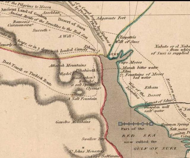
I note that the below map published in 1826 at Paris, France based on a survey done between 1796-1798 by Napoleon Bonoparte's Corps of French Army Engineers and Cartographers shows some 15 "fountains" wells? springs? in the vicinity of Ayun Musa "the wells of Moses" on other maps, rendered in French as "Fontaines de Moise."
Perhaps the Israelites accidentally "overlooked" 3 of these "fountains" and came up with a count of "12" instead of 15? The map's scale is 1:100,000. Published by C. L. F. Panckoucke at Paris, France in 1826. Please click here to access an interactive version of this map on the internet which allows you to scroll over it N-S, E-W, and enlarge or reduce its viewing scale; it is available at the David Rumsey Historical Maps Archive). I have colored in the 15 "fountains" with a light blue marker pen (1826. Paris, France. Publisher: C.L.F. Panckoucke. Carte topographique de l'Egypte et de plussiers parties des pays limitrophes..." Flle. 22. Suez)
A scientific explanation (2002) of Ayun Musa's 12 artesian springs:
"At Ayun Musa there are dozens of springs, shallow wells, and palm trees. The springs are a unique present-day watering place...The springs at Ayun Musa are artesian, flowing upward to the land surface along a fault...the springs have been in existence for many thousands of years. What is the source of this rich flow of water at the edge of the desert? Israeli hydrologists have determined that the Ayun Musa springs provide an outlet for a deep underground aquifer, or reservoir, storing a huge quantity of water. The water has been dated to about 10,000 years and is called paleo or fossil water. Artesian pressure forces this water to the surface to flow from springs and wells...the aquifer holds rainwater that was trapped during the most recent ice age and discharge it down the slope of water-bearing beds toward Ayun Musa where it discharges along a geologic fault."
(p. 26. Dr. Philip Elmer LaMoreaux and Judy T. Tanner. Springs and Bottled Waters of the World: Ancient History, Source, Occurence, Quality and Use. Berlin, Heidelberg, New York. Springer-Verlag. 2001)
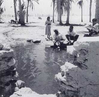
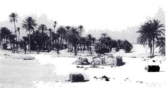
Below a photo of one of the springs at Ayun Musa taken in 1953 with accompanying description. The author notes that at least a "dozen springs" in the area discharge their waters naturally from an underground aquifer:
"A spring at Ayun Musa, or known in history as Moses' Spring. There are at least a dozen springs discharge points where water rises along faults from deep-seated beds in the cretaceous formation (photograph taken by P.E. LaMoreaux in 1953)." (p. 25. LaMoreaux)
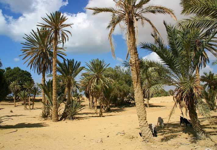
Below, a photo of palm trees at Ayun Musa (there are more than 20 trees in the photo, perhaps even more than 70 trees?):
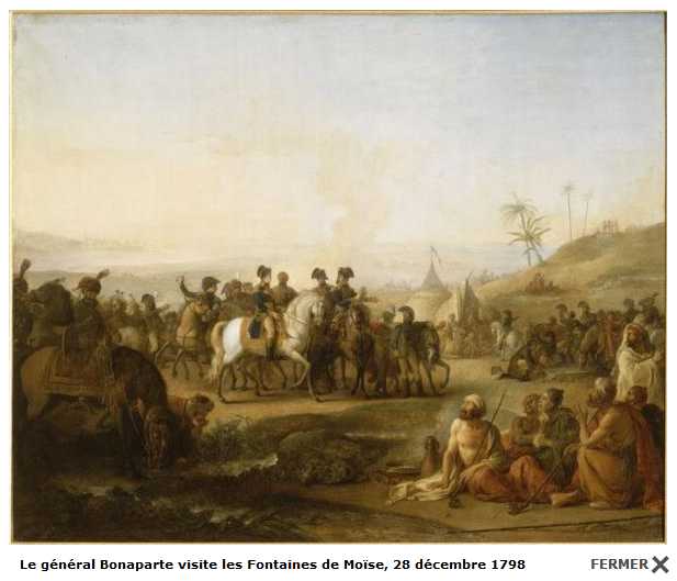
Below, a painting showing the French Emperor Napoleon Bonoparte visiting Ayun Musa in 1798. In the foreground (viewer's left) a horse and its rider drink from one of the springs near which some Arabs are seated on a mat.
Franz citing work by the Israeli scholar Professor Har-El who identified Ayun Musa with Elim:
"The Numbers account says that they camped by the Red Sea after their time in Elim (Num. 33:10,11). Somewhere at the entrance to the Wadi Sudr would be a good candidate for this campsite." (Apparently after this incident, the Israelites turned south to Elim with its twelve springs and 70 palm trees (Ex. 15:27; Num. 33:9). A good candidate for this site is one of the most prominent springs in the Sinai Peninsula, 'Ayun Musa. Two geologists observed that "there are twelve springs, from two of which good drinking water may be obtained" (Moon and Sadek 1921:2). In their geological report, they have pictures of this spring with palm trees in the area. When Robinson visited in 1838 he observed only seven springs (1977:90)."
(Gordon Franz. "Mt. Sinai is NOT at Jebel al-Lawz in Saudi Arabia." March 14, 2002)
Apparently (?) the work being cited is F. W. Moon and H. Sadek. The Topography and Geology of Northern Sinai. Petroleum Rersearch Bulletin. No. 10. Government Press. Cairo. 1921. 154 pages.
Professor Menashe Har-El of Tel Aviv University (1983) proposed that Elim was Ayun Musa, according to the map from his book (Sinai Journeys, The Route of the Exodus. San Diego, California. Ridgefield.1983 [earlier published in Hebrew at Tel Avi in 1968]) reproduced at the at the following url http://www.bibleprobe.com/Lawz.htm
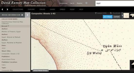
Below, a map showing 'Oyun Musa (Ayun Musa) with 12 wells in 1914 (See the David Rumsey Historical Map Collection on the internet, _Map of Egypt_ scale: 1:50,000 produced in Cairo by the Egyptian Ministry of Finance, sheets 1-92 of Lower Egypt, volume 1). Hydrologists have inspected this site and declared it is composed of 12 thermal hot springs thousands of years old. Nearby are stunted palm trees.
Apparently Hot Springs exist at 'Ayun Musa (Note: 27 degrees Celsius is 80.6 degrees Fahrenheit, 72 degrees Celsius is 161.6 degrees Fahrenheit):
"Three major groups of hot spring groups issue along the eastern coast of the Gulf of Suez. The northernmost group is that at Ayun Musa (27°C), which emerges from tension joints in Tertiary beds lying unconformably on the Nubian Sandstone. The second group, 90 km to the south is at Hamam el Far'un (72°C), where springs flow from the shore cliff of Gebel Hamam el Far'un. The waters issue from faulted, dolomitic Eocene limestones."
(p. 35. Issar, A., Rosenthal, E., Eckstein, Y. & Bogoch, R. "Formation Waters, Hot Springs and mineralization phenomena along the eastern shore of the Gulf of Suez." Bulletin of the International Association of Scientific Hydrology. Vol. 16. No. 3. pp. 25-44. September 1971)
Baedeker (1902) on the thermal springs at Ayun Musa:
"The Springs of Moses...form an oasis about five furlongs in circumference...the vegetation here is very luxuriant. Date palms and gardens are cultivated. The springs vary in temperature from 70 degrees to 80 degrees fahrenheit; some are only slightly brackish, while others are exceedingly salty. The largest of them, in the garden farthest to the south, is said to have been the bitter spring which Moses sweetened by casting a certain tree into it."
(p. 174. Karl Baedeker. Egypt, A HandBook of Travelers. Part 1. New York. 1902)
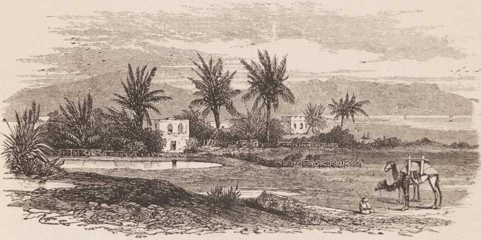
Below, a drawing showing springs or pools at Ayoun Musa (Ayun Musa) with palm trees and gardens, in the distance is the Gulf of Suez and mountains near its western shore (p. 201. Rev. Samuel Manning. LL.D. The Land of the Pharaohs. Egypt and Sinai: Illustrated by Pen and Pencil. The Religious Tract Society. London. 1911).
Below, a map published in 1817 showing Marah and Elim to be just north of Ayun Musa, "the Fountains of Moses," showing Israel's crossing of the Red Sea to be opposite Ayun Musa (Egypt. Robert Kirkwood, cartographer. Glasgow & London. 1817. An Atlas Map. Available at the David Rumsey Map Archive on the internet)
Below, a watercolor of Ayun Musa by Lady Louisa Mary Anne Tenison, circa 1843, from her published book, Sketches in the East, 1846.
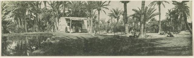
Below, an old photo of one of the springs at Ayun Musa, showing a hut and camels resting among palm trees to the viewer's right.