Marah of the Exodus, the Septuaginta Bible's Merrah, Morath of the Aramaic Peshitta Bible, is the Bitter Lakes, Arabic: Murrat.
21 April 2010 (Revisions through 01 October 2021)
I have proposed that Elim and its 12 springs and palm trees is Ayun Musa, the "Springs of Moses" which, according to some trained Hydrologists, possesses 12 artesian fountains (They are actually thermal hot springs).
As Marah preceded Elim it is my understanding that the Bitter Lakes, called murrah or murrat in Arabic meaning "bitter" are the Bible's "waters" of Marah. The Great Bitter Lake in Arabic: al-Buhayrah al-Murra al-Kubra, the Little Bitter Lake: al-Buhayrah al-Murra as-Sughra. They were a huge salt-marsh before the construction of the Suez Canal.
Professor James K. Hoffmeier (2005) apparently provisionally accepted (?) Professor Manashe Har-El's 1968 proposal that Marah might be Bir el-Mura, east of today's Port of Suez:
"Alternately, some more recent scholars, such as Manashe Har-El and George Kehn, propose Bir el-Mura as biblical Marah. The Arabic name murr is cognate with Hebrew Marah and means bitter...a connection between the site named in Exodus 15:23 and the present day Bir el-Mura is certainly plausible, and it would fit within the distance of a three days journey or approximately ninety-six kilometers/sixty miles from our proposed crossing point on the south side of the el-Balah Lake. Another possibility is to locate Marah at Ayun Musa, as Simons and the hydrologist Arie Issar have done." (p. 162. James K. Hoffmeier. Ancient Israel in Sinai, The Evidence for the Authenticity of the Wilderness Tradition. Oxford University Press. 2005)
Waters in Hebrew is mayim, the "-im" suffix being understood at times to be a plural form.
From various English translations it seems to me that there is more than one source of bitter water as Marah's water is referred to as "waters" not water and the accompanying plural form "they were bitter" rather than "it was bitter":
Exodus 15:23
New American Standard Bible
When they came to Marah, they could not drink the waters of Marah, for they were bitter; therefore it was named Marah.
King James Bible
And when they came to Marah, they could not drink of the waters of Marah, for they were bitter: therefore the name of it was called Marah.
American King James Version
And when they came to Marah, they could not drink of the waters of Marah, for they were bitter: therefore the name of it was called Marah.
American Standard Version
And when they came to Marah, they could not drink of the waters of Marah, for they were bitter: therefore the name of it was called Marah.
Douay-Rheims Bible
And they came into Mara, and they could not drink the waters of Mara, because they were bitter: whereupon he gave a name also agreeable to the place, calling it Mara, that is, bitterness.
Darby Bible Translation
And they came to Marah, and could not drink the waters of Marah, for they were bitter; therefore the name of it was called Marah.
English Revised Version
And when they came to Marah, they could not drink of the waters of Marah, for they were bitter: therefore the name of it was called Marah.
Webster's Bible Translation
And when they came to Marah, they could not drink of the waters of Marah; for they were bitter: therefore the name of it was called Marah.
World English Bible
When they came to Marah, they couldn't drink from the waters of Marah, for they were bitter. Therefore its name was called Marah.
Young's Literal Translation
and they come in to Marah, and have not been able to drink the waters of Marah, for they are bitter; therefore hath one called its name Marah.
of the waters
mayim (mah'-yim)
water; figuratively, juice; by euphemism, urine, semen -- + piss, wasting, water(-ing, (-course, -flood, -spring).
If more than one source is what is intimated by the term mayim "waters," the Bitter Lakes seem to fit the requirement of a multiple source of water as both lakes, al Buhayrah al Murrah al Kubra (Great Bitter Lake) and
al Buhayrah al Murrah as Sughra (Little Bitter Lake) bear the name murrah in Arabic (the Septuaginta Bible written in Greek at Alexandria, Egypt in the 3rd century BC for Jews by Jews renders Marah with two "r's" as Merrah which seems to be preserved in modern Arabic's murrah). These bitter lakes are north of my Elim (Ayun Musa) proposal Ayun Musa possessing 12 springs and palm trees according to various authorities. Please click here for my article identifying Elim with Ayun Musa's 12 springs (actually, they are thermal hot springs).
I have noted that the distance from the south shore of the Little Bitter Lake to Ayun Musa (my choice for Elim, following Har-El) is approximately 23 miles. By camel caravan this would be about a 10 hour ride, said caravan averaging roughly 2 1/2 miles an hour, or a day's journey (S. C. Bartlett in 1879 stated he was in the saddle of his camel for 10 hrs. upon reaching camp at 7 p.m. at Wady Gharandal from Wady Sudr south of Ayun Musa, having left Sudr at 9 a.m.). Professor James K. Hoffmeier has suggested that Israel's daily rate of travel in the Exodus was roughly 20 miles a day (using a Camel Caravan's daily rate of travel), but suggests up to 31 miles could be covered (He is proposing Etham is the area of Lake Et-Timsah and the "turn back from Etham" is to the Ballah Lakes area).
"A trek north from the Lake Timsah region and around the western side of the el-Ballah Lake system to its northern end would take one to the present day Qantara region, a distance of around fifty kilometers (thirty-one miles). This could place the ancient Israelites in the vicinity of the toponyms recorded in Exodus 14:2, that is, Pi-hahiroth, Migdol, Baal-zephon, and the sea through which they would pass." (p. 73. James K. Hoffmeier. Ancient Israel in Sinai, the Evidence for the Authenticity of the Wilderness Tradition. Oxford University Press. 2005)
Hoffmeier on 20 miles as the "average" days' journey for Israel:
"Using thirty-two kilometers (twenty miles) as the approximate distance for the average day's journey..." (p. 161. Hoffmeier. Ancient Israel in Sinai. 2005)
In the past, the late 19th century AD, some scholars suggested that Marah was Ain el Hawwara, a 2 hr. camel ride North of Wady Gharandal. Hawwara is usually described as possessing bitter water. However, at least one scholar noted that on his visit the water was palatable. He suggested that when the pool was low the water was bitter, when freshwater from rain filled it up to capacity it was less bitter. If this be so then Hawwara's water was not always bitter, which would not make it a candidate for Marah. Another strike against Hawwara is that it is only one spring disqualifying it as possessing "waters, THEY were bitter."
Palmer on Hawwara being a solitary spring:
"...we reached 'ain Hawwarah, which most previous travelers have sought to identify with the Marah of scripture. It is a solitary spring of bitter water, with a stunted palm-tree growing near it...The quality of the water varies considerably at different times, and on the present occasion it was not only drinkable but palatable...Hawwarah, signifies a small pool, the water of which sinks into the soil by little and little, leaving the residue unfit to drink..."
(p. 45. E. H. Palmer. Desert of the Exodus. New York. Harper. 1872)
Bartlett said it was 2 hrs. by camel from Hawwara to Gharandal, these sites he understood to be Marah and Elim. If this be so how did a 2 hour camel trip morph into a day's journey for Israel from Marah to Elim? It makes no sense, the distance is too short to be a day's journey.
Bartlett:
"...in one hour fifty five minutes from Ain Hawwara we entered Wady Gharandal...We followed the wady toward the sea...till, in a little circle of trees and shrubs, we found our tents nearly ready...after being about ten hours (nine hours and forty five minutes) in the saddle...Arriving in camp about seven it was past eleven when dinner was over."
(p. 203. Samuel Colcord Bartlett. From Egypt to Palestine through Sinai the Wilderness and the South Country. New York. Harper. 1879)
We have three strikes against the proposal of Marah being Hawwarah:
Strike One:
Only one pool of water exists negating the terminology of mayim meaning "waters" and "they were bitter."
Strike Two:
The water quality varies from palatable to bitter according to Palmer (1872); most bible scholars understand Marah, meaning "bitter," implies its waters were _always_ bitter, not sometimes bitter, sometimes not.
Strike Three (and your out of the ball game):
The distance of 7 miles between Hawwara and Gharandal appears to be "too short" for a day's journey, it was covered in under 2 hrs. by Bartlett's camels in 1879.
Because I understand Elim's 12 springs are to be identified with Ayun Musa's 12 springs, Ain el Hawwara cannot be Marah as it is south of Ayun Musa. Marah must be north of Ayun Musa and about a day's journey. The ten hour camel ride of Bartlett in 1879 from Wady Sudr to Wady Gharandal (9 a.m. to 7 p.m.) suggests the Little Bitter Lake is one day's journey to Ayun Musa/Elim by camel caravan.
Bartlett (1879) thought Marah was Hawwarah understanding it would have been a three days' journey, Israel assembling at Ayun Musa after God's victory over Pharaoh. It took him 6 hrs by camel from Ayun Musa to Wady Sudr where he camped. The next day's ride was apparently from 9 a.m. to 7 p.m. from Sudr to Gharandal (6 hrs. Ayun Musa to Sudr + 8 hrs. Sudr to Hawwara = 14 hrs, + 2 hrs. from Hawwara to Gharandal, thus from Ayun Musa to Gharandal = 16 hrs.)
"In favor of this place as the Marah of the scriptures, there are the distances from Ayun Musa (a fair "three days" journey for such a company)..."
(p. 200. Samuel Colcord Bartlett. From Egypt to Palestine through Sinai the Wilderness and the South Country. New York. Harper. 1879)
Bartlett on the travel time being three days or 16 hours from a Red Sea Crossing near Ayun Musa to Hawarah (about 47 miles) for the Israelites which averages out to about 15.5 miles a day for Israel's daily rate of travel (Gharandal is 7 miles S of Hawwara):
"The distance, given by Burckhardt, Ebers, and Laval as fifteen and a fourth hours, by Robinson sixteen and a half, found by ourselves and Graul sixteen hours, and by Tischendorf fifteen or sixteen hours, would be a good "three days" march to a cumbered host like the Israelites; and a suitable site for Elim is also found in due time."
(p. 198. Footnote 8. Bartlett)
Bartlett mentions a 6 hr. ride from Ayun Musa to Wady Sudr (p. 190) If we add his 10 hours from Sudr to Gharandal and subtract 2 hours from Hawwara to Gharandal (p. 203) it was 14 hrs from Ayun Musa to Hawwara via camels, and 16 hrs. from Ayun Musa to Gharandal.
Driver (1911) on the distances in miles between Suez, Ayun Musa, Hawarah (Marah) and Gharandal (Elim):
"...'Ayun Musa, 9 miles below Suez...Jebel Musa is Sinai, Marah is commonly placed at Hawwarah, 47 miles SE of "Ayun Musa...Elim in Wady Gharandel, 7 miles beyond Hawwarah."
(p. lviii. Reverend S. R. Driver. Doctor of Divinity. The Book of Exodus In the Revised Version with Introduction and Notes. Cambridge. The University Press. 1911)
Another factor in favor of Marah being the Bitter Lakes area is its prominence. All the caravans that crossed into Egypt via the Sinai from Judah and Jerusalem would know of the Bitter Lakes area which is quite large. Before the Suez Canal was completed in 1869 maps circa 1800-1850 showed these lakes to be low-lying salt-marshes. Obviously their saltiness would make their waters taste bitter.
I am not the first to suggest Marah of the Exodus might be the Bitter Lakes, that honor goes to a 19th century AD German scholar: Dr. Brugsch who proposed this notion as early as 1872 (He had Israel crossing the Red Sea at the Classical Lake Serbonis, modern Sabkha Bardawal east of Qantara in the northern Sinai).
Professor Brugsch (1881):
"The bitter waters, at the place called Marah, are recognized in the Bitter Lakes of the Isthmus of Suez."
(p. 398. Vol. 2. Heinrich Karl Brugsch. A History of Egypt Under the Pharaohs: Derived Entirely From the Monuments. to which is added a discourse on the Exodus of the Israelites. London. John Murray. 1881. Translated from the German text)
Classical Greco-Roman geographers commented on the Bitter Lakes noting they received this name after their bitterness, but that when a canal from the Nile passed through them they lost their bitterness and grew reeds and marsh grasses becoming the haunt of fish and migrating water fowl:
Strabo (64 B.C.-25 A.D.) on the Bitter Lakes which lost their bitterness with the freshwater from the Nile diverted through the Red Sea Canal (via Wadi Tumilat) which emptied into the Arabian Gulf (Gulf of Suez):
"There is another canal which empties into the Red Sea and the Arabian Gulf near the city of Arsinoe, a city which some call Cleopatris. It flows also through the Bitter Lakes, as they are called, which were indeed bitter in earlier times, but when the above-mentioned canal was cut they underwent a change because of the mixing with the river, and now are well supplied with fish and full of aquatic birds. The canal was first cut by Sesostris before the Trojan War -though some say by the son of Psammitichus, who only began the work and then died- and later by Darius the First, who succeeded to the next work done upon it."
(Strabo. Geography. 17. 1. 25 [p. 77 of The Loeb Classical Library Edition. Vol. VIII.] Harvard University Press. Cambridge, Massachusetts. 1932. Reprint of 1996)
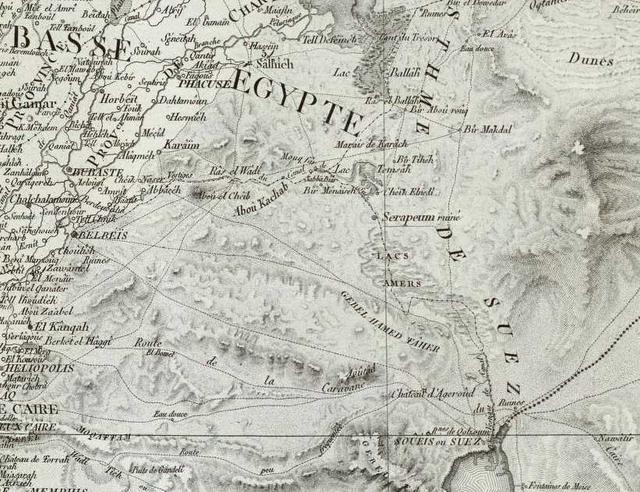
Below, a map in French, showing the Bitter Lakes as a marsh labeled Lacs Amers; near the right bottom edge of the map ESE of the port of Suez is Ayun Musa rendered in French as Fontaines de Moise (Published at Paris 1818 by C. L. F. Panckoucke. Map title: Carte geographique de l'Egypte et des pays environs).
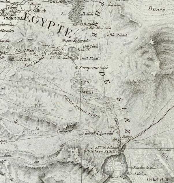
Below, a close-up of the above map:
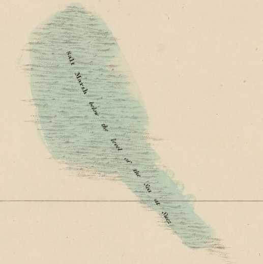
Below, a map of 1807 showing the Bitter Lakes ( the above 1796 French maps' Lacs Amers) to be a "Salt Marsh below the level of the sea at Suez." (Aaron Arrowsmith, cartographer. A Map of Lower Egypt from various surveys communicated by Major Bryce and other officers. London. Available at the David Rumsey Historical Map Archive on the internet). Today two lakes exist in this area due to the waters of the Suez Canal which passes through this great depression.
Professor Hoffmeier noted that salty water tended to be called mlh in Hebrew and malih/malha in Arabic, (p. 162. Hoffmeier) and that marah, meaning bitter (Arabic murr) seemed to him , an inappropriate term for a site who's waters were salty. Nevertheless, the salty marshes of Bitter Lakes were called in Arabic not malih but murra/murrat meaning "bitter" (The Encyclopedia Britannica renders them al-Buhayrah al-Murra al-Kubra, "Great Bitter Lake," and al-Buhayrah al-Murra as Sughra, "Little Bitter Lake"). The area encompassed by these two lakes today is about 250 kilometers. Such a huge area containing bitter water, seems, for me, to be a more likely Marah of the Exodus than Hoffmeier's choice of tiny, little, Bir el Mura (p. 162. Hoffmeier) opposite, east of, Suez.
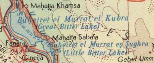
Below, a map of 1967 showing the Great Bitter Lake and Little Bitter Lake formed by the Suez Canal's water. Arabic murr/murra/murrat means "bitter." The Aramaic recension of the Bible renders Marah as Morath, which for me, recalls modern Arabic Murrat:
Exodus 15:23 "And when they came to Morath, they could not drink the waters of Morath, for they were bitter; therefore the name of the place was called Morath." (p. 83. George M. Lamsa's Translation From the Aramaic of the Peshitta. Holy Bible From the Ancient Eastern Text. Harper and Row, San Francisco. 1968. Originally published in 1933 by the A. J. Holman Company)