Israel's Red Sea Crossing at Lake Menzaleh, Egypt
05 January 2010
An English Canon, Reverend, and Vicar of Holy Trinity Church, Gravesend, England made a trip to Port Said on his doctor's orders for his health and resided at Port Said apparently from the Winter of 1881 to the Spring of 1882. While at Port Said he founded a Church for English Seamen. At some point in time while at Port Said he witnessed a stong east wind arising and blowing back the waters of Lake Menzaleh on the west side of the Suez Canal embankment. He proposed that Israel's crossing of the Red Sea was probably in this area based on the phenomenon he had witnessed. A.G. Weld (1885) in the below excerpts presents his proposals; Yam Suph (the Red Sea or Reed Sea) is identified as being Lake Menzaleh. Of interest here is that General Tulloch of the English Army was at Port Said about this same period of time and witnessed the blowing back of the waters too in late January of 1882 (his account can be accessed by clicking here). Tulloch said the wind began during the day while he was inspecting the Canal, wind blown sand blinding him, he returned to Port Said, when he arose the next morning Lake Menzaleh, WSW of Port Said, as far as the eye could see, was gone, only an exposed lake bottom existed ("line of sight" estimated at 7 miles by some scholars). That is to say, _overnight_, the sea was pushed back, just as Yahweh, _overnight_, pushed back Yam Suph for Israel to cross over (Ex 14:19-24).
"The part of the Yam Suph which lies to the eastward of the Suez Canal has lately been in a great measure reclaimed from Lake Menzaleh, and turned into land, so that we cannot now trace these remarkable effects of the east wind on that side of the Sea of Reeds, as we can still do to the west of the canal where as Canon Scarth says, "the waters of the Yam Suph can be seen, when there is a strong east wind, going back so rapidly that shoals of fish are left dead on the shore, the sea is changed to dry land, the waves flow back, and a way is opened through the midst of the sea, a practicable roadway for a host. The waves of the Yam Suph thus recede at Port Said, and there is a stretch of water between the Arab town and the French town that becomes dry by this process, and people walk over it as a short cut when it is so dried. What happens at Port Said under the lee of the houses and of the canal bank, would have happened with intensity on the far eastern shore where there is nothing but the sand. At that end of the Sea of Reeds, the east wind, blowing its waters back, made a way for the children of Israel to the dry ground along which they deployed, with the sea as a wall unto them on their right hand, and on their left."
I have drawn a dotted line upon the sketch map on the next page, shewing the extreme limit to which Canon Scarth believes the Yam Suph flowed back under the influence of the east wind, a distance which be it observed, would have enabled the Israelites to move forward in accordance with the Targum tradition..."
(pp. 290-291. A. G. Weld. "The Route of the Exodus." pp. 281-296. Rev. Samuel Cox, D.D., editor. The Expositor. London. Volume 5. 1885)
Weld, apparently following Dr. Brugsch (1876), understood Pi-hahiroth meant abyss and quicksand (Brugsch thought the Bardawil Lagoon was the Red Sea crossing point and was a quicksand site):
"...Pi-hahiroth, "the place of abysses or quicksands." Canon Scarth relates how when walking along the strip of sand parting the two seas, when the waters had gone back, he found the sand near this very Pi-hahiroth so dry it scarcely took the impression of camel's foot..." (p. 296)
"Canon Scarth agrees with Dr. Brugsch in identifying the present Bitter Lakes...[with] the waters of Marah..."
(p. 296)
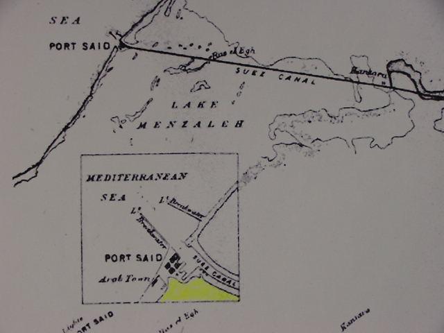
Below, a map showing the "Arab Town" at Port Said as west of the "French Town." I have colored in yellow marker the area where an east wind "blew back" Lake Menzaleh's waters exposing its bottom, allowing Arabs to cross on foot this area from the Arab Town to the French Town and the Suez Canal's western embankment.
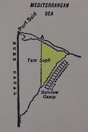
Below, A. G. Weld's "sketch map" (1885) showing Canon Scarth's proposal for the Crossing of the Red Sea by Israel in the Exodus. "A" is where the Mediterraneans Sea "broke through" a barrier island and inundated the dried up Red Sea/Reed Sea/YamSuph (the eastern end of Lake Menzaleh). Scarth had Israel on the barrier island near Port Said then crossing a dried up Lake Menzaleh southeastwards to the Pelusium plain (The "Hebrew Camp" shown on the below map is after having crossed the Red Sea). I have colored in yellow marker the exposed bed of Lake Menzaleh.
A map made in 1807, of Lake Menzaleh, by Aaron Arrowsmith, a cartographer, of London, states that the depth of the lake is usually 4 feet, but when the Nile inundation occurs it can rise to 7 feet. This suggests that the East Wind of 1882 was blowing away anywhere from 4 to 7 feet of water on the west side of Port Said, exposing dry land in the morning (map available at the David Rumsey Historical Map Archive on the internet. Aaron Arrowsmith. A Map of Lower Egypt from various surveys communicated by Major Bryce and other officers. London. 1807. Scale: 1:186,440).