Map of Rimmon-Perez (Rimmon-Parez) of the Israelite Exodus
16 June 2011 revisions through 03 December 2021
Numbers 33:19-20
"And they set out from Rithmah, and encamped at Rimmon-perez. And they set out from Rimmon-perez, and encamped at Libnah."
"Rimmon-Perez, pomegranate of the pass (breach), i.e., the pomegranate pass(?); King James Version: Rimmon-parez. One of the stopping places of the Israelites between Rithmah and Libnah."
(Vol. 4. p. 100. "Rimmon-Perez." George Arthur Buttrick. Editor. The Interpreter's Dictionary of the Bible, An Illustrated Encyclopedia. Nashville & New York. Abingdon Press. 1962)
"Rimmon-perez. A camping site of the wandering Exodus tribes, located somewhere between Rithmah and Libnah (Num 33:19-20). The modern site is unknown, but seems to be in the vicinty of the Negeb or the Sinai deserts."
(Vol. 5. p. 773. Patrick M. Arnold. "Rimmon: Rimmon-perez." David Noel Freedman. Editor. The Anchor Bible Dictionary. New York. Doubleday. 1992)
Conder (1915) proposed that Rimmon might be derived from Ramam "to be high" and accordingly rendered Rimmon-parez as "Cloven Height" (cf. "Rimmon-perez" in James Orr. Editor. The International Standard Bible Encyclopedia. 1915)
In the midst of this erosion crater lies Wadi er-Rumman (modern Israeli Nahal Ramon), also rendered as Wadi Raman in Arabic. I suspect Rumman/Raman preserves Rimmon and perez meaning "break," "breach," or "gap," is describing the erosion crater (technically called an "anticline") that Wadi Rumman/Raman runs the length of.
Strong's Hebrew and Chaldee Dictionary: Rimmon-perez, 7428, from 7426 , ramam, to rise. Perez, 6556, a break, a breach, a gap.
Archaeological surveys of this part of the Negeb (Negev) reveal Iron Age II settlements along the north edge of this _huge breach_ in the earth. Within the crater have also been found a few Iron Age II camping sites as well.
As for perez meaning also "pass" as in an "opening" or "gap" in a mountainous elevation, I note that an ancient track heading north from the south descends into the crater and then ascends from its depths going up the north face. So a "pass" as well as "breach" appear to be fitting descriptors of this erosion crater which saw Iron Age II Israelite settlement (circa the 9th-6th centuries BC).
At the western end of the erosion crater another ancient track passes by the height of Ras Raman (Ras in Arabic means "headland"), so the "pass" of Rimmon-perez might allude to this ancient track? From this height (elevation: 1,000 meters or 3,280 feet) one would have a magnificent view of the length of the erosion crater which runs east-west in a northeasterly direction.
The dimensions of this erosion crater or anticline:
length: 36 kilometers (22 miles)
width: 8 kilometers (4 miles)
Depth: 450 meters (1,476 feet)
Ras Raman: 1000 meters (3,280 feet)
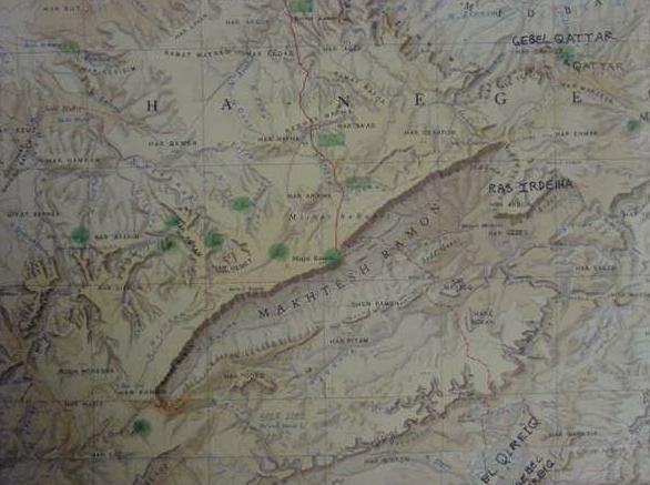
Some Liberal PhD scholars understand that the Book of Exodus was composed in the reign of King Josiah of Judah (ruled circa 640-610 BC) like Professor Israel Finkelstein. Others believe it was composed in the Babylonian Exile circa 587-547 BC. In either event, we are talking about Iron Age II as the "historical setting" or "backdrop" for the Exodus and Iron Age II settlements are documented for the vicinity of Hamaktesh Ramon. The green spots on the below map were made by myself with a marker pen showing "some" of the archaeological sites of Iron Age II period.
Finkelstein & Silberman (emphasis mine):
"Sites mentioned in the Exodus narrative are real. A few were well known and apparently occupied in much earlier periods and much later periods- after the kingdom of Judah was established, when the text of the biblical narrative was set down in writing for the first time. Unfortunately for those seeking a historical Exodus, they were UNOCCUPIED precisely at the time they reportedly played a role in the events of the wandering of the children of Israel in the wilderness...Lastly, ALL the major places that play a role in the story of the wandering of the Israelites were inhabited in the 7th century; in some cases they were occupied ONLY at that time."
(pp. 64, 67, "Did the Exodus Happen?" Israel Finkelstein & Neil Asher Silberman. The Bible Unearthed. New York. The Free Press. 2001)
Below, a map (from The Atlas of Israel. Jerusalem. Survey of Israel. 1970) showing modern Israeli Maktesh Ramon, an erosion crater. In Hebrew Maktesh means "mortar."
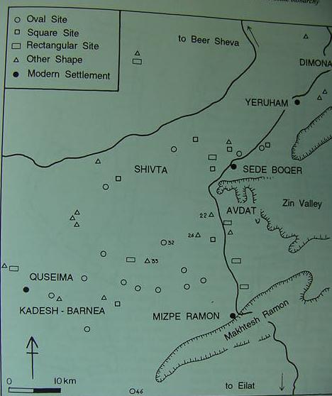
Below, a map of the Iron Age II "fortresses" in the Negev (cf. p. 105. "General Map of the Negev Highlands "fortresses." Israel Finkelstein. Living on the Fringe, the Archaeology and History of the Negev, Sinai and Neighbouring Regions in the Bronze and Iron Ages. Sheffield, England. Sheffield Academic Press Ltd. 1995, 2001).
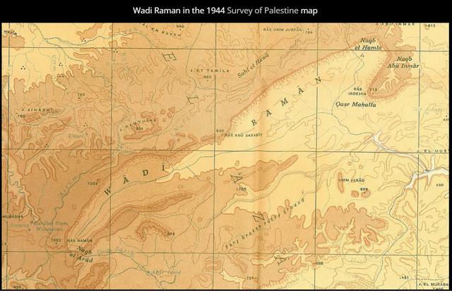
Below, a Survey of Palestine Map, circa 1944, showing Wadi Raman, today's (2021) Maktesh Ramon)