Map of the wilderness of Kedemoth (De 2:26)

Walter Reinhold Warttig Mattfeld y de la Torre, M.A. Ed.

10 March 2004 (Revisions through 08 May 2010)

 Please click here for Why the Bible Cannot be the Word of God

                                      Please click here for Why Jesus Christ cannot be the Messiah

The Wilderness of Kedemoth (De 2:26). Moses sends messengers from the "wilderness of Kedemoth" to Sihon the Amorite, asking permission to cross his lands. This is denied and Sihon engages Israel at Jahaz /Jahazah (De 2:32).  Kedemoth appears as a town for the tribe of Reuben (Josh 13:18) "...Jahaz and Kedemoth and Mephaath..."

Peterson noted there is no consenus amongst scholars for Kedemoth's location:

"There is not universal agreement regarding the location of biblical Kedemoth and the geogragphers give their suggestions tentatively. Kedemoth is a town situated N of the Arnon. It is probably an outpost toward the desert. It is impossible to define its location more precisely." (p.10 Vol. 4. John L. Peterson. "Kedemoth." David Noel Freedman. Editor. The Anchor Bible Dictionary. New York. Doubleday. 1992)

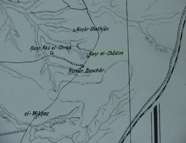
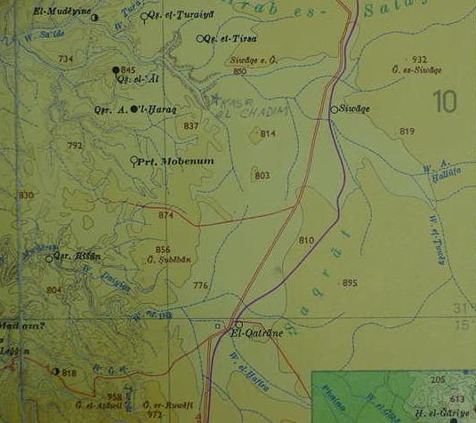
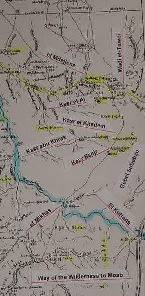
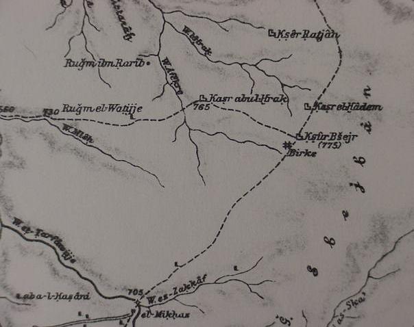
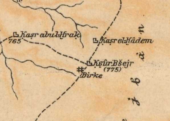
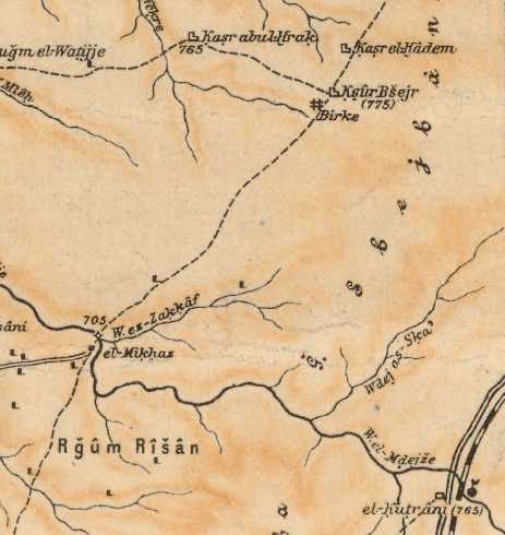
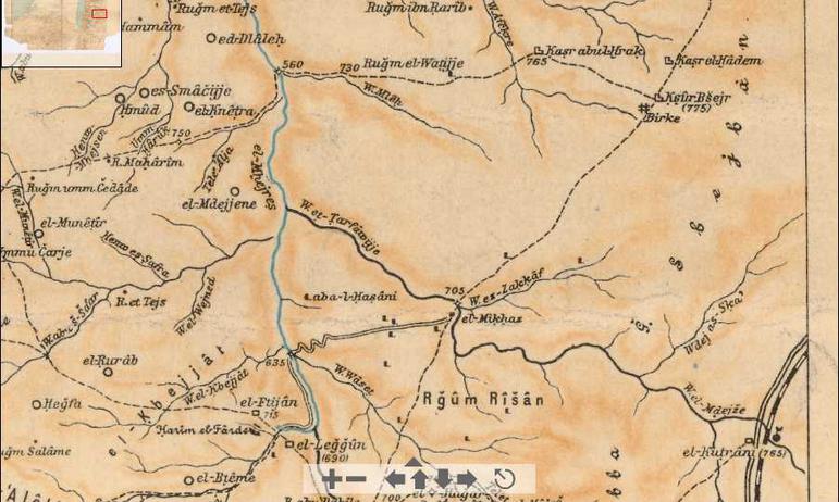
I suspect that Kedemoth is Qasr el Khadim, a site just west of the "way of the wilderness to Moab" which Israel was traveling enroute to Moab from Ezion Geber, Elath and the Gulf of Aqabah. Musil lists the site as Kasr Khadem (Alois Musil. Karte von Arabia Petraea. 1:300,000. Vienna. 1907), while a Geman map made in 1918, lists the site as Kasr el-Chadim (Bearabeit in der Kartogr. Abteilung der Kgl. Preuss. Landes. Aufnahme. April 1918, which appears "below" on this page). That is to say I understand that "the wilderness" _of_ Kedemoth is the wilderness _east_ of Kasr Khadem through which passes the "way to the Wilderness of Moab" taken by Israel.

It appears to me that biblical scholars (1907-2010) are "unaware of" just how important Alois Musil's map made in 1907 is, for it shows a site called Kasr Hadem (the diacritical under the H revealing it is pronounced Khadem, alternately Qasr Khadem) as the easternmost outpost of the area called in the Bible Sihon's Amorite kingdom. Had these scholars carefully studied Musil's map there would be no more wondering and confusion about where "the wilderness of Kedemoth" is!

As revealed on the below 1918 map, Kasr el Chadim is indeed "an outpost" overlooking the wilderness. The Arnon's eastern-most tributary does drain from the high tableland which Kasr el-Khadim sits atop (note the Arabic word Khirbet, meaning an abandoned site, is rendered as an abbreviation on the 1918 map as Ch. , for example between Arad and Hebron are the following khirbets : Ch. el-Karjaten, Ch. el-Fecht, Ch. u. Tell Ma`in, Ch. Ghanaim, etc.).

I understand that the "Wilderness of Kedemoth" is the wilderness to the east of Qasr el Khadem, through which passes the track called in the Bible, "the way of the wilderness to Moab." The 1918 map shows this track as a line with dots, which is paralleled by a railway.  I thus understand Israel camped  near the "Way of the wilderness to Moab" just east of el-Khadem, and south of Wadi et-Tuwei.

Perhaps biblical Bezer (Hebrew Beser with a diacritical dot under the "s") is Kusur Bescher (Musil's Ksur Bsejr), adjacent to and south of Kasr el Chadem on the 1918 map? Both sites lie on a high tableland. There is no consensus amongst scholars on Bezer's location.

Mattingly:

"Although its exact location is unknown, Bezer is often identified with Umm el-`Amad, which is located ca. eight miles northeast of Medeba." (p.719. Vol. 1. Gerald L. Mattingly. "Bezer." David Noel Freedman. Editor. The Anchor Bible Dictionary. New York. Doubleday. 1992)

De 4:43 RSV

"Bezer in the wilderness on the tableland for the Reubenites..."

Josh 20:8, RSV

"And beyond the Jordan east of Jericho, they appointed Bezer in the wilderness on the tableland, from the tribe of Reuben..."

 
Main Page   Archaeology Menu   OT Menu    NT Menu   Geography Menu

Illustrations Menu    Bibliography Menu    Links Menu
I have "penciled" in the location of Qasr el Khadem/Chadem with a star by the name (cf. the above 1918 map for Wadi et-Tuwey). I understand Israel as encamped south of es-Siwaqe (Jahaz/Jahazah, Strong # 3096 Jahazah, yah-tsawLXXIasaIassa, Eissa) and east of Qasr el Khadem (Kedemoth). I understand that the defile or valley to the west of the highlands region called es-Saqrat might be Zered." And that "the river _of_ Zered" is Wadi el Hafire, which drains into the Arnon towards Qasr Risan on the lower left corner of the map. One of Wadi Hafire's headwaters is Wadi es-Sekreyat, which drains from the ESE into Qa'el Hafire from Gebel es-Sekhreyat. Zered probably derives its name from either es-Seqrat or perhaps es-Sekhreyat. The below map is titled Palastina Historisch-Archaologische Karte. Blatt Sud. 1979. 1:300,000. Gottingen. Ernst Hohne [Redactor] & Hermann Wahle [Cartographer]. Click on the following url for a map showing the River of Zered (Massoretic Text) or "Valley of Zered" (Septuaginta & Vulgate Texts) which Israel camped at before reaching the "Wilderness of Kedemoth" (De 2:13-25).
Alois Musil's below map (Karte von Arabia Petraea, 1:300,000. Vienna. 1907) shows Kasr el Khadem on a track going north from Rugm Risan and el Mikhas to Birke, then Qasr Besjer (biblical Bezer ?), and Qasr el Khadem (Kedemoth ?). Just west of Khadem lies Qasr abu Khrak (Kasr Abu el Chrak on the 1918 map above). The track leaves Khedem, heading north to intersect with the lower reaches of Wadi et-Tuwei. The blue line marks the wadi from el Qatrane (Kutrane), whose eastern headwaters are Wadi Hafire and its head water Wadi es-Sekhreyat. I understand that wadi Hafire, crossing the "way of the wilderness to Moab" at Qatrane/Kutrane is possibly the brook of Zered, obtaining its name from either es-Saqrat or Wadi es-Sekhreyat which is one of its headwaters debouching from Gebel es-Sekhreyat into Qa`el Hafire (cf. Azraq. Sheet NH 37 A.  South Levant. 1:250,000. 1946.). If my suppositions are correct, the blue line marks the border between Israel and Moab in the Wilderness. These maps are part of my article titled "The Route of the Exodus."
Below, a close-up of Musil's above map showing a wadi Sejl es Sfej running from east to west (south of er-Ramma) a headwater of Wadi Mogeb (identified as the Arnon by some scholars) Musil's Sejl el-Mogeb. I have proposed that Kedemoth might be Musil's Kasr el Hadem (the H has a diacritical mark under it rendeing it Kh in sound, thus Hadem becomes Khadem). I have also suggested Bezer might be Ksur Bsejr (note the diacritical mark above the s) south of and adjacent to Kasr el-Hadem/Khadem.
Below, another closeup of Kasr el-Hadem (Khadem) and Ksur Bsejr, Kedemoth (?) and Bezer (?). Could Birke south of Bsejr be Beer (Numbers 21:16) which was encountered after crossing the valley/river of Zared/Zered, on the otherside of the Arnon?
Below, the same above maps but in color:
Please click here to access an interactive version of the above color map which allows you to scroll N-S, 
E-W and enlarge or reduce the map (Alois Musil's 1907 Karte von Arabia Petraea, published at Vienna, Austria) showing an area from Gaza in the west to the easternmost border of Moab in _mind-boggling detail_, wells (birs and mas) in blue and tiny hamlets and caravan stations, etc.