Gaston Maspero (1906) on the Euphrates' water level fluctuations with the seasons:
"The Euphrates rises in the middle of March, and does not attain its highest level till the close of May. From June onwards it falls with increasing rapidity; by September all the water which has not been absorbed by the soil has returned to the river bed. The inundation does not possess the same importance for the regions covered by it, that the rise of the Nile does for Egypt."
(p. 21. vol. 3, Gaston Maspero, Angelo Solomon Rapport, et al. History of Egypt, Chaldea, Syria, Babylonia, and Assyria. London. The Grolier Society. 1901-1906?)
Maspero on the fluctuating rise and fall of the Euphrates, some of who's overflow apparently (?) winds up in the Eridu basin:
"The overflowing waters of the right bank, owing to the fall of the land, runs towards the low limestone hills which shut in the basin of the Euphrates in the direction of the desert; they are arrested at the foot of these hills, and are diverted onto the low-lying ground, where they lose themselves in the morasses, or hollow out a series of lakes along its borders, the largest of which is Bahr-i-Nedjif, is shut in on three sides by steep cliffs, and rises or falls periodically with the floods."
(p. 26. G. Maspero)
Maspero's comment about the end of May being "high-water" for inundated land by the Euphrates seems to be borne out by the below satellite photos of the basin Eridu lies in (note especially the 06 June photo for the "high-water inundation in the basin). A large depression in the earth called the Khor el Nejeif appears to fill up with Euphrates runoff on its western side first, then runoff from this fills via various streams flowing from west to east (?) the basin east of ancient Eridu (if my untrained eye is rightly reading the satellite photos).
The below satellite images are from the internet and some are from the United States Geological Survey web site. They are of different years and months. I assembled them as a succession of months to illustrate Maspero's above comments on the Euphrates' fluctuating rise and fall, inundating of the land by late May and early June. The dates represented are: 26 March, 24 April, 29 May, 6 June, 20 July, 3 December and 20 March.
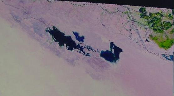
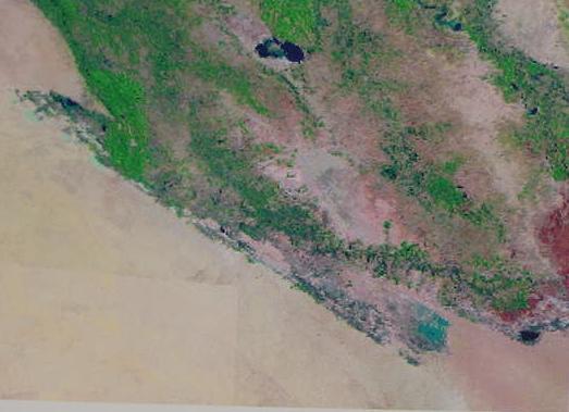
Below: 26 March 2009. Satellite Photo. L7 SLC-off (2003.) List. Resolution: 240 M. Lat./Long. 31.208811, 45.143922 degrees. The Khor el Nejeif depression or basin has filled with Euphrates runoff to the west of Eridu. The basin east of Eridu has not yet begun to fill up.
Below: 24 April 2008. Collection: Tel Aster (2000). Resolution: 155 m. Latitude: 31.0 Longitude: 46.1
The western lagoon forms first (?) due to its higher elevation (?) its overflow eventually spills eastward into the easternmost lagoon which is lower; it has not reached maximum or highest water level yet. The dark triangular area (viewer's right) is either a shadow caused by the cliffs forming the eastern boundary of the Sebkha east of ancient Eridu, or a part of the sebkha filling up from two wadies emptying into it from its northwest corner, from the high alluvial plain east of Ur, the eastern sebkha begins as two sebkhas? Below the "triangular shadow (?) or "sea" (?) is a reddish brown dark spot or "smudge" which appears to be (?) the southern portion of Sebkha lagoon east of ancient Eridu, increasing in size. If the northeast corner is "part" of the eastern sebkha, then at full inundation these two sebkhas apparently (?) merge into one huge sebkha. That is to say this photo shows "four" rather than "three" sebkhas surrounding Eridu.
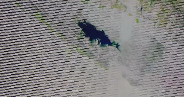
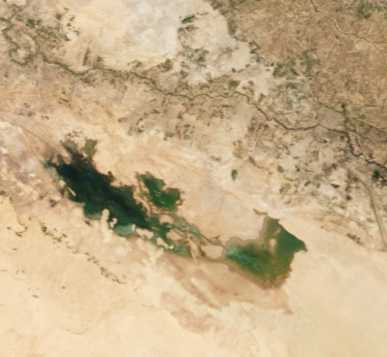
Below: 06 June 2006. Collection: Global Land Survey. GLS 2005. Resolution: 240 m. Latitude: 30.3 Longitude: 45.8
The Khor el Nejeif basin at "High Water" or maximum inundation, possessing three lagoons (?). Eridu lies on the west shore of the farthest east (viewer's right) lagoon. Note the spillover streams from the higher western lagoon (west of Eridu) entering the lower lagoon (Sebkha) east of Eridu. Note: Compare this image of high water with the "next photo" posted at Google Earth purportedly showing the Sebkha freshwater lake east of ancient Eridu at High Water. Gaston Maspero (1906) said high water was towards "the end of May" for the Euphrates' inundation; regretably, I was unable to find a satellite photo for the "end of May," the best I could do was one week after the end of May: 06 June 2006 for an example of the seasonal high water inundation. The below photo suggests two islands exist in the midst of the Sebkha east of Eridu. The two sebkhas east of Eridu have merged now into one sebkha.
Dr. Gwendolyn Leick, PhD, Karl Franzens University, Graz, Austria, Fellow of The Royal Anthropological Institute, on Eridu, its topography, and Sebkha or Abzu that at times of high water becomes a "sizable lake":
"Eridu is the Mesopotamian Eden, the place of creation...the Mesopotamian Eden is not a garden, but a city, formed from a piece of dry land surrounded by the waters. The first building is a temple. Then mankind is created to render service to god and temple...Eridu is the ancient name of a site now known as Abu Shahrein...the city...was built upon a hillock within a depression about twenty feet below the level of the surrounding land, which allowed the subterranean waters to collect together. This swampy place can still become a sizable lake in the months of high water. The earliest Mesopotamian texts, from the early third millennium, underline the importance of this lagoon. In Sumerian this was known as the Abzu (in Akkadian Apsu).
(pp. 1-3. "Eridu, Creating the First City." Gwendolyn Leick. Mesopotamia: The Invention of the City. London. Penguin Books. 2001, 2002)
The depression Eridu lies in has been described as being like a "sea" in the rainy season, receiving rainwater discharges from Wadi Khanega SW of Suk esh-Sheiukh:
"The site of Eridu...nearly in the centre of the dry bed of an inland sea, a deep valley, 15 miles at its broadest, covered for the most part with a nitrous incrustation...In the rainy season this valley becomes a sea flooded by the discharge of the Khanega; in the summer the Arabs dig holes here which supply them with brackish water."
("Eridu." Encyclopedia Britannica. 1911) Note: Iraq's "rainy season" is November through April.
Below: 03 December 1990. Collection: Global Land Survey 1990. Resolution: 240 m. Latitude: 30.3 Longitude: 45.8
An "empty" Eridu basin (all three lagoons are dry) with some "dampness" (?) appearing as a dark brown "smudge" where the eastern lagoon (Sebkha) existed back in June.
Please click here For my article on ancient Eridu, identified by some PhD scholars (1885-2001) as being the pre-biblical prototype for the biblical Garden of Eden and additional satellite photos.
If the Khor el Nejeif does indeed fill up with water from late May to early June, could the three bodies of water appearing in the 06 June 2006 satellite photo be of the "interconnecting lagoons" mentioned in ancient exts about Eridu?
Ancient hymns speak of Enki's (Ea's) Abzu shrine (ziggurat) casting its shadow over "the sea." The western shore of the Sebkha Lagoon abutts Eridu, which Leick described as being built upon a hillock in a depression 20 metres below the alluvial plain ancient Ur lies upon. That is to say the hillock protects Eridu from the Sebkha lagoon to its east.
Ochsenschlager (2004) on the importance of the Tigris and Euphrates rivers and their seasonal inundations or floods' effect upon the expansion and contraction of bodies of water including marshes (al Hiba is the modern name for the ancient Sumerian city of Lagash):
"In 1968 al-Hiba was surrounded by contiguous areas of permanent, seasonal, and temporary marsh. Melting snow in the mountains to the north caused the annual floods. The inundation reached its height in May and began to recede in June. By August the temporary marsh was covered with a growth of sedge and grass ready to welcome the nomadic Bedouin who arrived with their herds of goats, sheep and camels to take advantage of the pasturage. The waters reached their lowest point in September and October. In November the water level rose slightly, and, with the rainy season in late December or early January, sudden short floods could occur...When the Tigris and Euphrates Rivers flood, from March to July, the marshes were at their greatest extent both then and now. In the 1960s and 1970s the floods were much more dangerous and the marshes would attain a depth of four to five feet fairly close to the marsh banks and much deeper in places farther away from the shore...Winter is also the rainy season, especially from the end of December through March, with the heaviest rains in January and February...The marshes were a thing of beauty. During the fall and winter migrations they were filled with wild birds- ducks, geese, ibises, pelicans, and cranes. Other birds, such as owls, kingfishers, eagles and quail, seemed to be permanent residents. Carp, the most common fish in the marsh, furnished ample supplies for the fishermen who caught them for food, sale, or barter...Several varieties of poisonous snakes lived here..."
(pp. 8-9. "In the Garden of Eden." Edward L. Ochsenschlager. Iraq's Marsh Arabs in the Garden of Eden. Philadelphia, Pennsylvania. University of Pennsylvania Museum of Archaeology and Anthropology. 2004)
Hilprecht (1903) on the months of May, June and July being the time of high flood water for the area about Ur, and that the area is so flooded this site can be reached only by boat at this time of the year:
"At the beginning of 1854...excavations were also undertaken at Muqayyar...The ruins of Muqayyar are situated upon a slight elevation six to seven miles southwest from the modern town of Nasriye. The country all about is so low that frequently during the annual flood of the Euphrates, i.e., from March till June or July, the ruins form practically an island in the midst of a large marsh, unapproachable on any side except in boats."
(pp. 171-172. "J. E. Taylor." Herman V. Hilprecht. Explorations in Bible Lands During the 19th Century. Philadelphia. A. J. Holman & Company. 1903)
Perhaps floodwaters from the plain about Ur spilled over the basin edge flooding the area about Eridu, making it, like Ur, an island in a great marsh approachable only by a shallow draft boat (canoe) too?
Willcocks (1919) remarking that the Euphrates' inundation was at its highest on the 5th of May in 1909:
"About the 5th of May 1909, when the flood was at its highest, I was riding up the left bank of the Euphrates from Ramadi to Hitt..."
(p. 17. Sir William Willcocks. From the Garden of Eden to the crossing of the Jordan. London. E. & F. N. Spon, Ltd. 1919. 2nd edition. Please click here to access his book digitalized by Google and available on the internet)
"The earliest settlements of the people of Sumer were made inside the level plain perennially under water, where well-protected dykes kept out the floods, which are never more than three feet above ground-level..."
(p. 30. Willcocks. 1919)
In Willcock's day, 1919, some scholars (Professor A. H. Sayce, 1887, of Oxford) thought Eridu lay on the shore of the Persian Gulf, and one can find today (2009) maps showing _in error_ Ur and Eridu as sea ports. Willcocks strenuously objected. As a trained irrigation works engineer he was sure the Persian Gulf had always been where it is today, south of Basra. I find his aruments compelling and well-reasoned-out:
"Salt water has never reached the marshes, owing to the delta of the Karun and the Kerkha lying between them and the sea. The effect of the ten-foot tide in the Persian Gulf has been and is communicated to the rivers, and travels up nearly a hundred miles, but no salt water has entered the marshes. To the original writers of these epics, the Deep was a fresh-water deep. The Karun river has played no small part in the formation of the Tigris-Euphrates delta...It has been the main factor in forming the comparatively high-lying land which stretches from Basra eastwards. This tongue of land protects the Tigris-Euphrates swamps from the inroads of sea water, and keeps them fresh. The Basra bar is formed almost entirely of Karun mud. The Tigris and Euphrates mud lies faraway to the west. In ancient times the Karun and Kerkha had but one outlet; but, 500 or 600 years ago, the Kercha left the higher-lying Karun delta, and has been since discharging its waters into the Euphrates and Tigris swamps."
(p. 26. Willcocks. 1919)
Willcocks believed that Apsu and Tiamat (his Tehomat, who both lived in myth, at Eridu) were dieties associated with the Euphrates' annual flooding, he did not associate Tiamat with the salt-water Persian Gulf (he thought Ea of Eridu was pronounced Yeh-hua, who later became the Bible's Jehovah or Yahweh):
"Apsu, the flowing and ebbing but limitable fresh-water lake, appeals to Tehomat, the illimitable and ever-moving flood, to help him overthrow the beneficent works of Maraduch...so opens the Epic of Creation...Yeh-hua...mastered Apsu and the marshes but it was Maraduch, the last born of these gods, who entrapped Tehomat with a network of canals and dykes..."
(pp. 31-32. Willcocks. 1919)
The prophet Ezekiel understood that the cedar trees in the Garden of Eden in the Lebanon mountains drew their water from a subteranean water source called tehom (tehom rendered into English as "the deep" Ez 31:4). I suspect Willcocks is right, Apsu and Tehom, who in myth live at Eridu, are but two manifestations of freshwater. Ab-zu is rendered by Langdon (1931) as nether (zu) sea (ab) and the husband of Tiamat in myths. She seeks to annihilate the gods her chldren who have killed her husband at Eridu. She is killed by Marduk of Babylon, the "son of Ea." Perhaps then, Abzu/Apsu is the freshwater sea "under" the earth (the "nether" world) while Tiamat is this sea in its manifestation of "rising" from the underworld to fill in hollows in the earth such as springs and wells? In some cases rivers arise from mountain springs. So Ezekiel's subterranean tehom is Tiamat "welling-up" or "rising" from under the earth to water the trees in the Garden of Eden? Enki/Ea dwells in the Abzu/Apsu and cylinder seals show two rivers erupting from his shoulders, perhaps an allusion to subterranean waters rising-up or welling-up from under the earth to become rivers?
Willcocks noted three reasons why Sayce thought Eridu lay on the Persian Gulf and refutes each of these reasons:
"The Reverend Professor Sayce is of the opnion that though salt water may not today enter the marshes, it was very different in old times, and that for three reasons. The first is the fact that the Babylonian writers seem to use the same word for the marshes as for the sea; the second is the fact that Eridu was the port of the country and was built on a horn of the sea; and the third is the fact that the first man was believed to have lived at Eridu and fished in the sea, and every day presented a dish of food to his deity. To this I reply that, like their descendants the modern Arabs, these ancient peoples had but one word for perennial river, fresh-water lake, and sea, just as they had but one word for plain and hill when they were out of reach of the flood and consequently desert. This is the key to understanding the history of the Flood as we have already seen...With the geography of the country as it has always been and is today, no salt-water can ever have reached the marshes, since the high-lying delta of the Karun river has lain between the low-lying delta of the Tigris and Euphrates and the sea; and these latter rivers have been forced to cut a passage through the Karun delta in order to reach the Persian Gulf. Far from it having been possible for salt-water to have entered the marshes in the remote past, I can assert that the further we go back the less was there any chance for the sea to have penetrated into the marshes. The less the quantity of water withdrawn from the Tigris, Euphrates, Kerkha and Karun for purposes of irrigation, the more difficult was it for the sea to travel up. In the time of Babylonia's greatest prosperity, when nearly the whole discharge of the Tigris and Euphrates was used up in irrigation, even then salt-water did not reach the marshes, because irrigation of the Karun and Kerkha was undeveloped, and the Babylonians moreover had their reservoirs. It is possible that when, in the future, all the water of the four rivers will be withdrawn from them for irrigation, sea water may travel up the marshes...in the remote times of the Epic of Creation, the marshes were not only fresh as they are today, but they probably covered three and a half million acres, instead of covering two and three-quarter million acres as they do today. The fact that Eridu was the port of the country in no way affects the question. Basra is the port today, and is removed 60 miles from the sea, and is visited by ocean-going steamers drawing from 16 to 18 feet of water, while the water in front of it is fresh and is utilised for irrigating millions of date trees."
(p. 26. Willcocks. 1919)
Note: Willcocks' map is incorrect, click here to view it: (1) He incorrectly has Ur and Eridu on the Euphrates; (2) He incorrectly has Eridu east of Ur on the Euphrates. The reality is that Ur is actually 12 mles NW of Eridu on a high alluvial plain, while Eridu lies in the Khor el Nejeif basin, 20 feet below Ur's ground surface. Satellite photos reveal two channels exist today of the Euphrates. One channel is north of Ur, the other channel services Eridu's basin via the sebkha west of Eridu.
I have cited from the above authors because some of this information might be of help some day to some "future researcher" looking for satellite photos of a flooded basin near Eridu. Apparently the "best time" of the year to find a satellite photo of a fully flooded basin would be the months of May, June and July when the Euphrates is at its peak in its inundation.
It would be nice to have a collection of satellite photos showing the monthly rise and fall of the three/four freshwater sebkha lakes surrounding ancient Eridu. I cannot but help wonder if in antiquity, 5000 years ago, these sebkhas could on occasion engulf Eridu's mound (Tell abu Shahrein) making of it an island in a fresh-water "sea." Tell abu Shahrein's stone-lined perimeter wall of gypsum (sandstone) would help protect it from such flooding. Two "islands" appear in the midst of the sebkha lagoon east of Eridu in the satellite photo of 06 June 2006.
Professor A. H. Sayce (1887) of Oxford understood that the cuneiform tablets located Eridu at the mouth of the Euphrates, at the shore of the sea which he equated with the Persian Gulf, but he was wrong as revealed by the satellite photos posted here:
"...Eridu, the city stood stood at the mouth of the Euphrates and the edge of the Persian Gulf...Eridu at the mouth of the Euphrates and on the shore of the sea..."
(pp.135, 142. Archibald Henry Sayce. The Hibbert Lectures, 1887, Lectures on the Origin and Growth of Religion as illustrated by the religion of the ancient Babylonians. London. Williams & Norgate. 1897)
Sayce was right about the ancient descriptions mentioning Eridu being near the "mouth" of the Euphrates and a sea shore, but the "sea shore" was the western perimeter of the fresh-water sebkha lake east of Eridu as revealed by the above satellite photos, not the shore of the Persian Gulf. This fresh-water lake or sebkha receives its waters from the Euphrates so, in a sense, a "mouth of the Euphrates is near Eridu (note: the Euphrates has _several_ mouths because in antiquity it was subdivided into several streams via canals that served several different Sumerian cities).
Several scholars have noted that as freshwater mussels were found in Eridu's ancient strata that it was not on the shore of the Persian Gulf, it was probably in a marsh lake most likely fed by the Euphrates or a canal:
Wilson (1925):
"Captain R. C. Thompson, who dug at Eridu in 1918, noted quantities of freshwater mussels in the lower strata, which prove the city stood by a freshwater lake. This fact and the considerations adduced below, suggest that we are not justified in assuming, as professor Langdon appears to have done in the Cambridge Ancient History, vol. 1, pp. 399-400 and map 9 (inset), that these cities stood on the seaboard."
(p. 225. Sir Arnold T. Wilson. The Delta of the Shatt Al Arab and Proposals for Dredging the Bar." The Geographical Journal. vol. 65. no. 3. (March 1925) pp. 225-239)
Hall (1930):
"One thing is clear, that, as Thompson says, Eridu can hardly have stood on the actual shore of the Persian Gulf, however far inland the sea may have come in early days. Not only does the ancient aquatic fauna of the place, of which we find remains, show this, but geological considerations also make it improbable. In early times Eridu may have been situated at the end of a winding backwater of the gulf (very like that which at the present time runs behind Basrah in the direction of Shaiba), into which fell a branch of the Euphrates, or a canal leading from the Euphrates near Ur. In the brackish liquid of such a "back" water shellfish could live. Shahrain actually looks as if it had stood in the centre of a marshy lake (connected in someway with the freshwater 'Apsu' of Eridu?), out of which it rose an island like Ely in the fens: a lake like the modern Hammar on a very small scale, perhaps originally at the end of a backwater, and connected with ther Euphrates either directly or by canals and so with the sea: for Eridu, though it never stood on what we call 'the sea', was in very early days undoubtedly a seaport. This lake, we may suppose, gradually dried up as its canals ceased to be used, and Eridu was finally abandoned to the desert."
(p. 220. Harry Reginald Hall. A Season's Work at Ur, al-`Ubaid, Abu Shahrain (Eridu) and Elsewhere: Being an unofficial account of the British Museum Archaeological Mission to Babylonia, 1919. London. Methuen & Co. 1930)
Below, a photo believed to be of the Sebkha lake east of ancient Eridu at time of high water, which aligns with the "above photo" of 06 June 2006 showing the lake east of Eridu filled nearly to the basin's edges. Dr. Collins of the British Museum (20 April 2009 e-mail) expressed reservations about this being a photo of the basin east of Eridu stating he was unaware of such high water levels in recent times. If I am reading the above satellite photo of 06 June 2006 "rightly" this basin does appear to indeed fill up to such high water levels. Again, I must stress I am an amateur with no training in interpreting satellite images and what constitutes bodies of water.
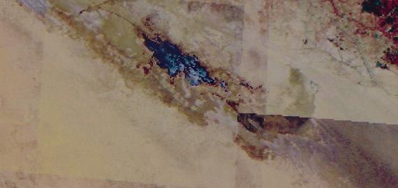
Eridu Basin Satellite photo of 20 July 2008 (Resolution: 155 m. ASTERVNIR Scene List). Shown below is the Sebkha-lagoon _west_ of Eridu. The Euphrates river appears to be the source of this lagoon's water, a southern channel entering at the lagoon's western end (The channel appears as a dark line from the viewer's upper left corner).
Apparently (?) the Sebkah east of Eridu has already dried up leaving only dark dampened earth in the basin. The Sebkha west of Eridu still has water but it is shrinking in size.
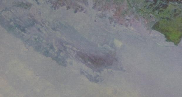
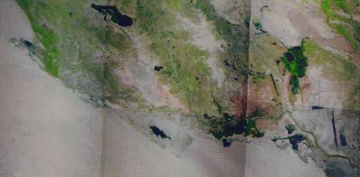
Below, the Eridu basin photographed by satellite on 29 May 2003 (240 m. resolution. L7 SLC-on 1993-2003 list).
The surprise?
By the end of May according to Maspero the Euphrates has reached its peak flooding, there sould be three freshwater filled lagoons here but there are none (scroll to the top of this page for their appearance on the 06 June 2006 satellite photo).
Conclusions:
Apparently the Euphrates does _not_ "always" muster enough water every year to fill the channel that services these three lagoons. Perhaps this "spotty" or "fickle" water delivery service is "why" Eridu was abandoned at times in antiquity? Only a man-made canal from the Euphrates could guarantee year-round freshwater for (1) drinking water, (2) fields, (3) orchards and (4) fish ponds and when the canal fell into disrepair the inhabitants had to abandon the area.
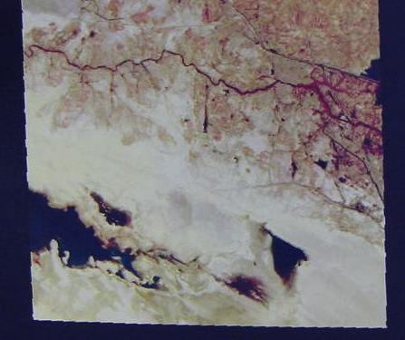
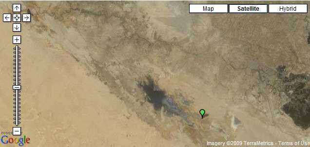
Below, a satellite photo showing that the basin Eridu lies in is a part of much greater depression in the earth forming the western border of the alluvial plain of the Euphrates river (20 March 2001. Resoultion: 1000 m. TL ETM+ (1999-2003 List. United States Geological Survey). Apparently this great depression in the earth gets its greenery from a channel of the Euphrates river. This channel apparently ends in the sebkha lagoon east of Eridu (shown as a turquoise blue patch at the east end of the depression)
Below, a wider panorama view of the above satellite image of 26 March 2009 showing other lakes filled (black areas) by the Euphrates as it begins rising in March.
Fluctuating water levels as revealed by satellite images of the basin ancient Eridu lies in
09 May 2009 (Revisions through 20 July 2012)
For over 100 years Eridu has been identified by various PhD scholars trained in Biblical and Ancient Near Eastern Studies as being the Mesopotamian _equivalent_ of Genesis' Garden of Eden where a man looses out on a chance to obtain immortality for himself and mankind (Adapa of Eridu being recast as Adam and his god Ea being recast as Yahweh), a notion I am in agreement with. The below satellite photos are to show the viewer what the earthly Mesopotamian "paradise" looked like and identify the source of Eridu's garden's water: the Euphrates river.
Please click here for more satellite photos of Eridu. Ur of the Chaldees (modern Tell Muqqayar, "the mound of pitch") where Abraham lived according to some scholars is 12 miles NW of Eridu, so Abraham lived "very near" the Mesopotamian equivalent of Genesis' Garden of Eden. On a clear day Abraham standing atop the ziggurat shrine at Ur could see the Eridu ziggurat. Both ziggurats had been built by Ur-Nammu circa 2100 B.C. the king of Ur and a contemporary of Abraham. I have drawn the modern (1980s?) levee walls about Eridu and its 7 mounds, and the modern levee road from Eridu to Ur. The area about Eridu apparently still floods and the levees protect this area from flooding and the levee highway allows access to Eridu during the flood season (May-June-July). In 1903 Hilprecht noted that during these flood months the plain about Ur becomes a vast marsh and the only way to get to Ur was via shallow-draft boats used by the natives. Undoubtedly, Eridu must have flooded and became a temporary marsh as well as Ur.
Below a satellite view showing the flood waters (gray areas) of the sebkha west of Eridu being restrained by the modern levee walls erected (circa the 1980s?) about ancient Eridu and its seven mounds or tells. The flood waters are clearly deliniated by the SW and SE levee walls. The ancient Tell mound of Eridu (the Ziggurat) can be seen as a very faint circle within the NW and NE levee perimeter walls (note: there are _no_openings in these walls suggesting to me their function is to keep the area from being flooded by the sebkha). Ancient texts suggest marsh existed up to Eridu's ancient walls, so this area probably flooded in antiquity like it does today. The green spot marks the SW levee wall surrounding today ancient Eridu.
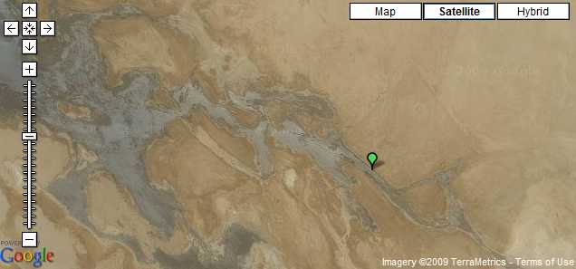
The major source of the water for the western sebkha appears to be a canal further to the west which enters the sebkha on its westernmost edge. How ancient or modern this canal is I do not know. This canal is just barely visible in the below satellite photo, but the very contorted Euphrates river from which it leaves is very clearly seen (viewer's upper left side). The green spot marks the location of ancient Eridu.
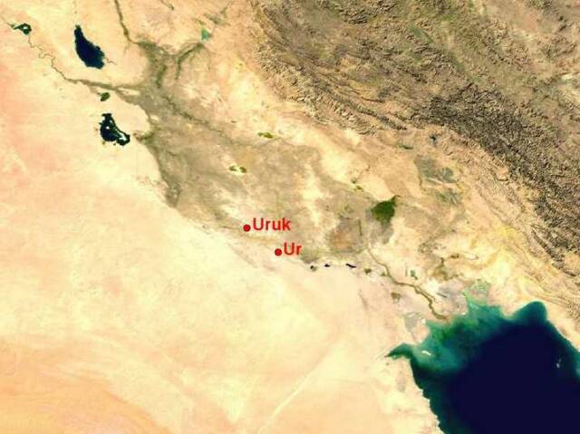
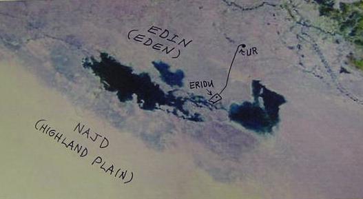
Below, a satellite photo of Lower Mesopotamia showing the great plain which is flooded by the Tigris and Euphrates rivers and was called edin by the Sumerians in the 3rd millennium BC texts. Eridu is not on the photo but it is 12 miles SW of Ur in the Khor el Nejeif basin which appears as dark smudge in the photo south of Ur.
Below, satellite view of Eridu's sebkhas, photo taken 08 February 2007.