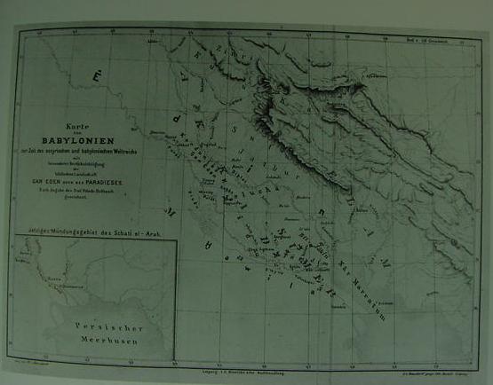
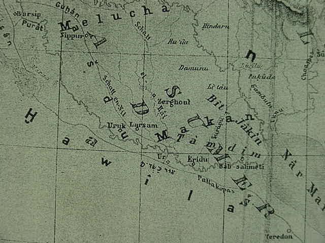
Below, Professor Friedrich Delitzsch's (a prominent German Assyriologist) map (1881) of Babylonia ("Karte von Babylonien") showing the location of the Garden of Eden ("Gan Eden") just south of modern Baghdad and north of ancient Babylon ("Babel"). The whole Mesopotamian plain is identified as being "Edin" (In 1881 he shocked the scholarly world by declaring that Genesis' Hebrew `eden was derived from the Sumerian edin which means "plain" or "steppe") from Hit on the Euphrates west of Baghdad to the border of ancient Elam. The Pishon River ("Pisan") flows west of Babylon, Havilah ("Hawilah") is southwest of Ur and Eridu. The Gihon river ("Guhan") is the Shatt en-Nil east of Babylon, Uruk and Eridu. He locates the island of Dilmun at the head of the Persian Gulf, just right of the "t" in Nar Marratum (p. 349. Figure 11.3. Alessandro Scafi. Mapping Paradise, A History of Heaven on Earth. Chicago and London. University of Chicago Press & The British Library, London. 2006).
Scafi on Delitzch's proposals:
"He placed the site of paradise on the Euphrates between Baghdad and Babylon. The four rivers were to be identified with the great canal to the west of the Euphrates that had been called the Pallacopas by the Greeks (which Delitzsch thought was the Pishon), the Shat-en-Nil (the Gihon), the lower Tigris (the biblical Hiddekel) and the Euphrates."
(p. 348. Scafi)
Scafi's bibliography:
Friedrich Delitzsch. Wo lag das Paradies? Leipzig. J. C. Hinrich. 1881.
Please click here to access Delitzsch's book, written in German, digitalized by Google for on-line reading.
Roger's summation (1909) of Delitzsch's proposals (1881) regarding the location of the Garden of Eden and its four streams:
"Some of the adherents of this view look upon the Genesis accounts as based upon ignorance of geographical facts or as wholly ideal. Delitzsch and Dillman may be cited as the chief names in support of this hypothesis. The former says:
"The inspiration of the biblical writers did not, in matters of natural knowledge, raise them above the level of their age; it need, therefore, cause no surprise if the biblical represention of Paradise bears marks of the imperfect geographical knowledge of the ancients."
"(3) Eden was in northern Babylonia near the city of Babyon. This location was first suggested by Friedrich Delitzsch in 1881. According to him Eden was the whole plain of Babylonia, and Paradise was located where the Tigris and Euphrates most nearly approach each other. The river Pison is the great canal Pallakopas, running west and south of the Euphrates (Assyrian pisanu = river bed) and the Gihon with the canal Shatt al-Nil, which runs east from the Euphrates from Babylon and rejoins it near Ur. On the whole this theory seems best to meet the conditions laid down in Genesis, but its acceptance among scholars has not been general." (Robert W. Rogers. "Eden." pp. 5-6. Vol. IV. Samuel M. Jackson. Editor. The New Schaff-Herzog Encyclopedia of Religious Knowledge. Funk and Wagnalls Company. London. 1909)
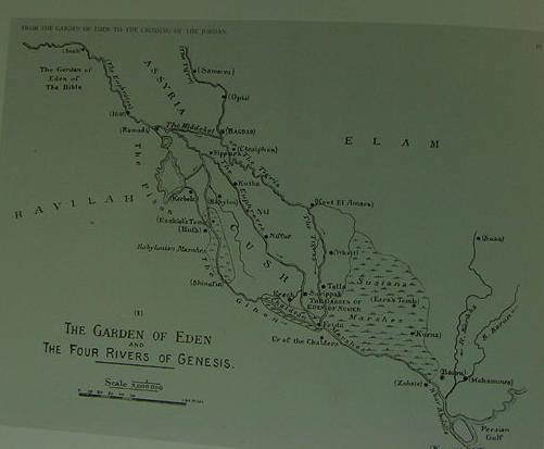
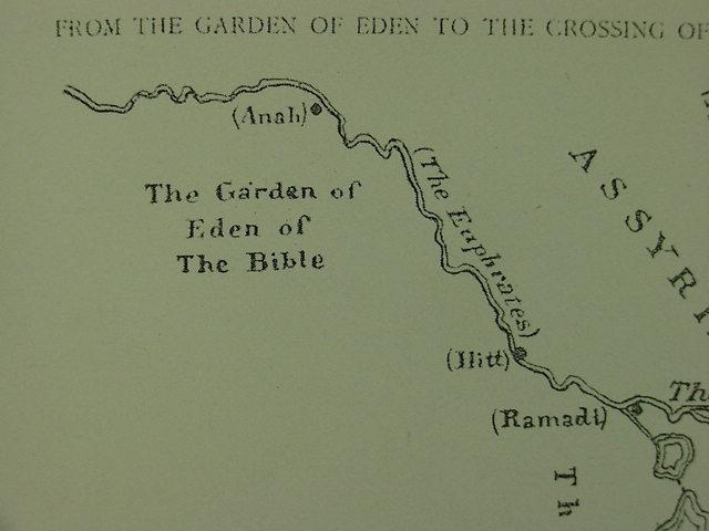
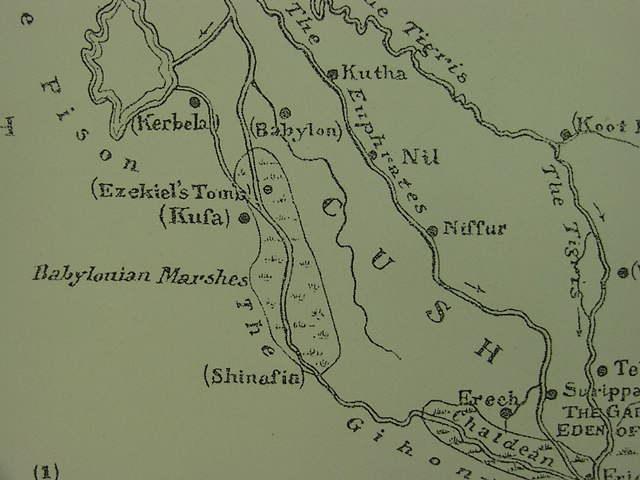
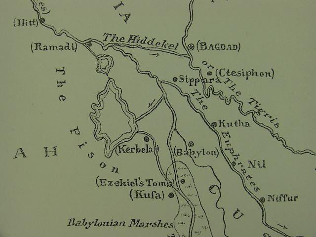
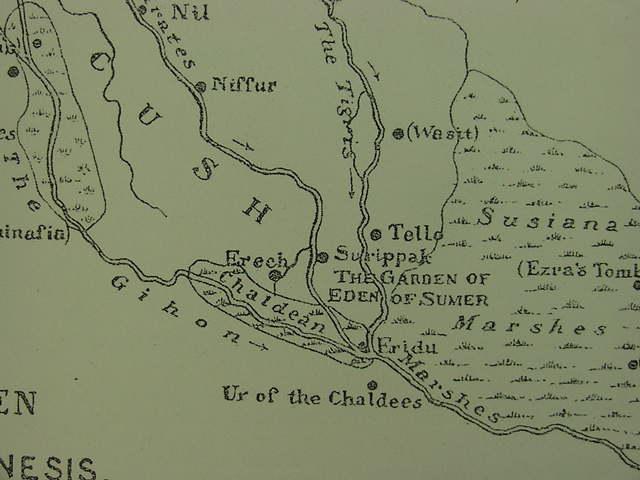
Below, Sir William Willcocks' map (1919) of the Garden of Eden which he locates as a region near the city of Anah on the Euphrates west of Assyria. He locates the "Sumerian" Garden of Eden between the Sumerian cities of Eridu, Shuruppak and Girsu ("Tello"). Surprisingly he locates Ur (Ur of the Chaldees, modern Tell al Muqayyar or Mugheir) as south of Eridu instead of as north of the site. The Pishon River is the Euphrates between Ramadi and Kerbela in the same general area as Delitzsch (cf. above map) and the Gihon is the Euphrates west of Uruk ("Erech"). Havilah is west of the Euphrates and Cush is south of Babylon and north of Uruk ("Erech"). Of interest here is that Willcocks map shows the mouth of Tigris as meeting the mouth of the Euphrates at Eridu and in Sumerian myths the land of Dilmun was "at the mouth of the rivers," generally understood to be the mouth of the Tigris and Euphrates rivers. However Dilmun is not listed on the map. Special Note: Willcocks' Eridu on modern 21st century maps is the location of Ur, whereas his Ur is Eridu! (p. 350. Figure 11.4. Alessandro Scafi. Mapping Paradise, A History of Heaven on Earth. Chicago and London. University of Chicago Press & The British Library, London. 2006)
Scafi on Willcocks' proposals (Willcocks was a trained engineer of irrigation systems and waterworks):
"For Willcocks, the key was, perhaps predictably, irrigation, which was for him the oldest applied science in the world. He traced the way, as he saw it, that ancient civilizations arose in irrigated valleys through the organization and discipline implied by a successful watering system. From this premise he went on to interpret the biblical description of the earthly paradise as indicating that the Old Testament Garden of Eden lay somewhere along the Euphrates where the Garden could have been watered by a natural flow all through the year. In his personal experience of the area, there were only two such localities: one was the region of the cataracts beyween Anah and Hitt, in Assyria, and the other was the marshland beginning at Nasiriyah, near the ruins of Ur of the Chaldeans. Willcocks designated the first as the biblical Garden of Eden, the cradle of the Semitic race, the second as the Garden of Eden of the Sumerians, their earliest settlement; he marked both on the first of the four maps in his book (Figure 11.4)...The biblical Pishon corresponded to the flooded depressions of Habbania and Abu Dibis that lie between Ramadi and Kerbela and to the east of Havilah (between Egypt and Assyria), which can thus be described as 'encompassed' by the biblical river (Genesis 2.11). The Gihon corresponded to the modern river Hindia (or Pallacopas). The land of Cush was between Babylon and Erech. The river Hiddekel is shown on his map as a short stream flowing from the Euphrates to the Tigris at Baghdad, south of Assyria, and a branch of the Euphrates as flowing through Babylon."
(pp. 349-350. Scafi)
Scafi's bibliography:
William Willcocks. Map titled "The Garden of Eden and the Four Rivers of Genesis" from his book titled
From the Garden of Eden to the Crossing of the Jordan. Cairo. The French Institute of Oriental Archaeology. 1919.
Please click here to read Willcocks book which has been digitalized by Google for on-line reading.
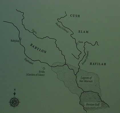
Below, Manfred Dietrich's map (he is a professional scholar and Assyriologist). He thought that Eden was Eridu and the Garden _of_ Eden was a temple-garden _in_ Eridu. Dietrich identifies the Gihon and Pishon rivers with the Kercha and Karun which flow south from Iran. Cush and Havilah are for him located in modern Iran. (p. 351. Figure 11.5. Alessandro Scafi. Mapping Paradise, A History of Heaven on Earth. Chicago and London. University of Chicago Press & The British Library, London. 2006)
Scafi on Dietrich's proposals:
"As recently as 2002, Manfred Dietrich proffered his idea, based on a comparison of the Genesis narrative with ancient texts, that the site of the Garden of Eden is at Eridu, in southern Mesopotamia, at the point where fresh river water meets the salt water of the sea (Figure 11.5). Dietrich pointed out that in Eridu there was once a temple dedicated to the Mesopotamian god who created mankind, Enki/Ea, traditionally represented in Mesopotamian art with four rivers. Like Sayce and others before him, he recognized these four rivers as precisely those mentioned in Genesis and whose mouths were in that area. He took his interpretation from a number of texts describing the creation of man in temple gardens and recording environmental changes at the head of the Persian Gulf. In the pairing of the Genesis rivers -the Pishon with the Gihon and the Tigris with the Euphrates- Dietrich also saw an allusion to the oppositon of the two contemporary political powers, Elam and its implacable enemy, Babylon." (p. 351. Scafi)
Scafi's bibliography:
Manfred Dietrich. 'Das biblische Paradies und der babylonische Tempelgarten: Uberlegungen zur Lage des Gartens Eden', in Das biblische Weltbild und seine altorientalischen Kontexte. edited by Bernd Janowski, Beate Ego, and Annette Kruger. Tubingen: Mohr Siebeck. 2001. Please click here to read on-line Dietrich's article.
also: pp. 280-323. Dietrich, 'Der "Garten Eden" und die babylonischen Parkanlagen im Tempelbezirk', in Religiose Landschaften, edited by Johannes Hahn and Christian Ronning. Munster in Westphalia. Ugarit Verlag. 2002. pp. 1-29.
Highly reccomended is the following recently released book which is very scholarly and profusely illustrated with a wonderous array of maps in black and white as well as color attempting to locate Paradise on the earth from Early Medieval times to as late as 2002 (Scafi is a lecturer at the University of Bologna, Italy and the Victoria and Albert Museum, London):
Alessandro Scafi. Mapping Paradise, A History of Heaven on Earth. The University of Chicago Press & The British Library, London. 2006. ISBN 0-226-73559-1 Hardbound. 398 pages. Please click here to purchase the book.
The second-place "runner-up" to Scafi's magnificent tome, is for me, another fine scholarly work (but with much fewer maps, all are black and white, no color) which traces various ideas about Paradise and its location from Early Medieval times to the 19th century A.D.:
Jean Delumeau. History of Paradise, The Garden of Eden in Myth and Tradition. New York. The Continuum Publishing Company. 1995. translated from the French edition: Une Historie du Parais: Le Jardin des delices. Librarie Artheme Fayard. 1992. 276 pages. Please click here to purchase the book.
Conclusions:
For me, the biblical Garden of Eden _really cannot be located_. Why? Its a mythical place and and its river system as described in the BIble is mythical as well. The Euphrates and Hiddekel (Tigris) are presented in Genesis as two streams arising from a _single_ river in Eden and modern hydrological and geological surveys reveal that these two streams _never_ arose from one river. That is to say both the Euphrates and Tigris arise from _different and separate_ tributary systems_ , they do _not_ arise from a single shared stream as presented in the Bible.
Perhaps the notion that one stream in Eden becomes four streams recalls the archaeologically attested fact that the Euphrates (one stream) became three (or four streams?) in the floodplain of Lower Mesopotamia near ancient Sippar, with the "fourth stream" being the Hiddekel/Tigris that merged with the Euphrates near Sippar to become the "fourth" stream flowing through Lower Mesopotamia during the 5th-2nd millenniums B.C.? If this is what is being recalled in Genesis then either Mari or Sippar would be my choice for the location of the biblical Garden of Eden, where one stream becomes four streams, but as noted, the various motifs associated with Eden's Garden are from several Mesopotamian myths and different sites: Eridu, Uruk, Nippur, and Anu's heavenly abode. So, in the final analysis the pinpointing on a map of "_one_" pre-biblical Mesopotamian site for Eden's Garden possessing _all_ of the motifs and events found in Genesis is actually QUITE IMPOSSIBLE!
A number of Christian Apologists also claim the Garden of Eden can never be found, but for the wrong reason. They claim that the Euphrates and Hiddekel did indeed once upon a time arise from a shared single stream in Eden, but that Noah's Flood has erased this river system burying it under tons of flood sediments. The problem? The internal chronology of the Bible presents Noah's Flood as an event occurring in the 3rd millennium B.C. and Geologists have found no such evidence of a worldwide flood. Archaeologists date some villages in the Ancient Near East as early as the Neolithic Period, the New Stone Age and the 12th millennium B.C. and they report _no_ evidence of a world destroying flood sediment from this period right up to modern times, the 21st century A.D. Please click here for all the details on the findings of Science: Archaeologists, Geologists and Palaeo-hydrologists regarding Noah's "mythical" flood.
I understand that the Garden of Eden and its motifs are later Hebrew recastings of similar motifs found in a number of earlier Mesopotamian accounts about primal man and his life in the edin and how the gods took him from this edin to work their city-gardens on their behalf. So _for me_ the Garden of Eden is a Hebrew _refutation and denial_ of the "many" gods' city-gardens in the edin appearing in various Mesopotamian myths. Pease click here for more details and accompanying maps.
Professor Batto of DePauw University (1992) on Genesis' author recasting motifs from the Atrahasis Epic which explained why man was created: to care for the gods' gardens:
"It is important to notice that Yahweh was the original gardener. It was he who "planted" the garden in Eden and made to grow there..."the tree of life" and "the tree of knowledge of good and evil" (2:8-9)...Humankind, it seems, was created to work this garden for the deity: "Yahweh God took the human and placed him in the garden of Eden to cultivate it and to care for it" (2:15). Surely we are here picking up an echo of Atrahasis. In that myth humans were created as substitute laborers for lesser gods, who had revolted from performing this arduous chore for the benefit of the high gods. There is, of course, no revolt of lesser gods here...humankind was originally created to relieve the deity of the burden of cultivating his own plantation or "garden"...As in Atrahasis, the function of humankind was divine service, a service that included providing provisions for the deity."
(pp. 50-51. Bernard F. Batto. Slaying the Dragon, Mythmaking in the Biblical Tradition. Louisville, Kentucky. Westminster/John Knox Press. 1992)
If I am correct about Eden's motifs and concepts being "cherry-picked" from various Mesopotamian compositions who did it and when? I suspect Abraham did it circa 2100 B.C. He began life as a polytheist according to the Bible, he lived at Ur (modern Tell al Muqayyar, Mugheir, Mughayir, "the mound of pitch" south of Babylon, which is _near all these sites_, Sippar, Nippur, Uruk, Eridu), presumably he would have had over a period of some 75 years (Ge 12:1-4) as a _practicing_polytheist_, an "intimate knowledge" of Mesopotamian religious myths and concepts. When he became a monotheist at age 75 (?) at Haran (?) or Canaan (?) he took these now "disavowed" Mesopotamian concepts and recast them via a series of inversions and reversals into what would eventually be preserved and transmitted by his descendants in the book of Genesis, which I understand was written circa 560 B.C. in the Exile. Please click here for Genesis' 560 B.C. composition.
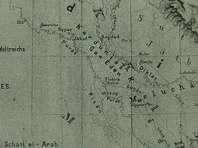
Below, a closeup of the Garden of Eden (Hebrew: Gan Eden) as Akkadian: Kardunias. The Pishon (Pisan on the map) flows west of Babylon (Tintira/Babel) while the Gihon (Guhan or Gukhan) flows east of Babylon (Tintira/Babel) to Sippar. The Euphrates (Purat) is north of Babylon (Tintira/Babel) and east of the Pishon (Pisan) and south of Babylon (Tintira/Babel). The land of Melucha (Melhuhha) is south of Babylon (Tintira/Babel).
Professor Clay (1923) on Delitzsch's attempt to identify Eden and its rivers and Sayce's suggestion Eridu is Eden:
"...Delitzsch endeavored to locate Eden in Babylonia, where besides the Tigris and Euphrates he identified the Pison as the Pallicopas canal, and the Gihon as the Gukhande (also called Arakhtu)...Another effort was also made to locate Eden at Eridu in Southern Babylonia...One of the traditions...referring to Eridu, is the Legend of Adapa...which...has...resemblance to the story of Adam and his fall, it is claimed, was transformed and recast into that story. Others regard this legend as a direct prototype which had certain influences upon the development of the Genesis story...For many years Professor Sayce has held that Adapa was identical with Adam..."
(pp. 108-109. "Adam, the Garden of Eden, and the Fall." Albert T. Clay. The Origin of Biblical Traditions, Hebrew Legends in Babylonia and Israel. New Haven. Yale University Press. 1923). Please click here to read Clay's book which is available for on-line for reading.
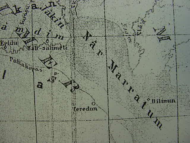
Below, The land of Makan (Magan) is south of Melucha (Melukhkha). Note: I am somewhat in agreement with Delitzsch, that Dilmun, Melukhkha, and Magan/Makan are to be found in or near the marshlands east of Lower Mesopotamia _contra_ modern proposals that these locations are to be associated with Bahrain, the Indus valley and Oman. Special Note: Delitzsch's map has Ur and Eridu in the _wrong_ locations. Modern 21st century maps show his Eridu to be Ur and Eridu's location is actually south of Ur's (He incorrectly has Ur to the west of Eridu). Actually Eridu is about 12 miles SW of Ur.
Below, a closeup of Willcocks' proposal for the Garden of Eden near Anah on the Euphrates. Willcocks understood that the Bible clearly described Eden's river as subdividing after leaving the garden into four streams thus the reason why he located the biblical Garden of Eden between Anah and Hitt.
Below, Willcocks' Pishon (Pison) river extends from Ramadi on the Euphrates to Kerbela (Kerbala). The Hiddekel (Tigris) river is portrayed as "a branch" of the Euphrates from Ramadi to just south of Baghdad (Bagdad). Note: some scholars understand on the basis of modern hydrological surveys that the Tigris in antiquity during the 6th-2nd millenniums B.C. merged with the Euphrates near Sippar. Later both streams moved apart from each other to their present positions. Several scholars have noted that in antiquity the Euphrates subdivided into three principal channels or streams upon entering the great flood plain of Lower Mesopotamia near Sippar and that the merging of the Tigris with these three streams became the river of Eden that became four streams. Please click here for all the details and maps.
Below, the Gihon river appears to be a branch of the Euphrates passing to the westside of Babylon and extending to Eridu (the Pishon river reconnecting to the Gihon river south of Kerbala)
Below, Willcocks' map (1919) shows "where" Professor A. H. Sayce of Oxford (1887) thought the Garden of Eden was located:
"About the locations of the Garden of Eden of the Bible and the Garden of Eden of the Epic of Creation there is, however room for divergence of opinion. That the Sumerian Garden of Eden was located where the Reverend Professor Sayce had long ago placed it, viz. at the ancient junction of the Tigris and Euphrates in the marshes north of Ur of the Chaldees, there is to my mind not the shadow of a doubt." (p. 34. Willcocks)
"The location of the Garden of Eden of the Bible is more difficult. Professor Sayce places it at the same meeting of the Tigris and Euphrates, with the Kerkha and Karun rivers flowing into their joint waters lower down." (p. 35. Willcocks)
Below, Delitzsch's proposal for the location of the fabled land of Dilmun with the Nar Marratum "the bitter river" associated with the Shatt al-Arab ("[river]bank of the Arab") which daily receives bitter salty water from the Gulf in powerful tidal flows reaching the vicinity of Basrah. Dilmun can be found near the lower right corner of the map.
Hastings (1907) on Delitzsch (1881) placing Dilmun under the delta silts of the Shatt al-Arab:
"The geographical position of Dilmun (more correctly Tilmun or Tilwun), an Arabian district adjoining the Persian Gulf, has been misconceived owing to an erroneous translation by Delitzsch of a passage referring to it in inscriptions of Sargon. Delitzsch has been followed by Winckler, the result of the mistranslation being a series of geographical difficulties which have proven insurmountable. Dilmun has been supposed to be an island, which Rawlinson identified with Bahrein on acount of an inscription which had been found there, while Delitzsch was forced by the length of the Assyrian kasbu to make it some islet which has long since been absorbed by the growth of the silt at the head of the Persian Gulf...Sargon (of Assyria) speaks of the Kalda territory of Bit-Yakin in the marshes at the mouth of the Euphrates as 'extending to Dilmun' (adi pat Dilmuni).
The passage on which the misconception of the geographical position of the country has rested is the following (Sarg. Ann. 369-370, Khors. 144): Uperi sar Dilmuni sa malak xxx. kasbu ina qabal tamdim nipikh samsi kima nuni sitkunnu narbatsu, 'Uperi, king of Dilmun, whose place of retreat was made like that of a fish, at a distance of 30 kasbu in the middle of the sea,' where the relative has been supposed to refer not to the king, but to the land of Dilmun, regardless of the comparsion with a fish."
(James Hastings. Editor. The Expository Times. Vol. 18. Oct. 1906 to Sept. 1907. pp. 234-235. Edinburgh, Scotland. T. & T. Clark)
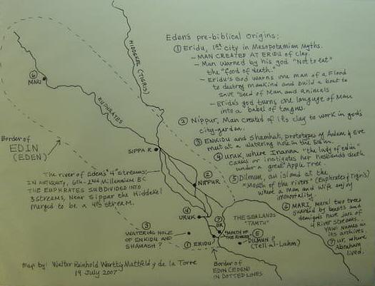
Below, my map proposals (19 July 2007) for the Garden of Eden:
For me the "location" of Garden of eden _cannot be fixed_ because I understand it is mythical and never existed. However, it is drawing from motifs originally associated with "other places" in the Mesopotamian myths. So this map attempts to plot the "pre-biblical sites" that were fused together into "one" site, the mythical Garden of Eden, rather than attempt to pinpoint the garden's position based on the Bible's description.
I am in agreement with Delitzsch (1881) that the Sumerian Edin is what lies behind Genesis' Eden (note: Dietrich, 2001:320, thought Eridu had been transformed into Genesis' Eden and its temple garden was recast as the Garden of Eden).
I understand that just as the Hebrews challenged the Mesopotamain notion that there were many gods and goddesses responsible for creating the world and man, so too, they repudiated the notion that their city-gardens in the eden/edin existed. There was only _one_ God and thus there could be only _one_ God's garden in Eden, _not_ many gods' and goddesses' city-gardens in eden/edin.
Because edin is a Sumerian word and refers to the uncultivated land surrounding every Sumerian city and its gardens or fields, the "land of Eden," is, in effect, the land of Sumer. But by the end of the 3rd millennium B.C. Sumerian colonies had been founded in Syria and Edin came to be extended as a term to also embrace Syria. That is to say by the 3rd millennium B.C. edin/eden was the uncultivated lands surrounding the Mesopotamian cities of both Upper _and_ Lower Mesopotamia. Many people in error think that Sumerian edin came to be eclipsed as a word with the rise of Akkadian (Babylonian). Professional scholars, however, are aware that many Sumerian words survived in the Akkadian written documents down to the Neo-Babylonian period of the 6th century B.C. in the form of logograms, a shorthand way of writing an Akkadian word. For example, in the Epic of Gilgamesh which is written in Akkadian several Sumerian words exist as logograms in lieu of writing out the Akkadian word. A logogram is a single sign, which is much faster to write than spelling out all the vowels and consonants in an Akkadian word. The Sumerian logogram used in lieu of the Akkadian word seru is edin! Within the Epic of Gilgamesh, the Akkadian scribe sometimes writes out s-e-r-u, but on other occasions, he substitutes seru with the edin logogram! That is to say Sumerian edin survived right down to the days of 6th century B.C. Exile of Israel and Judah as a logogram commonly employed by Akkadian scribes.
Sumer's "eden/edin" (marked off with a dotted line on the below map) is the "earliest" precursor of Genesis' `eden. The term applies to uncultivated steppeland or plains surrounding Sumer's cities and their gardens/fields. The gods' gardens/fields were never called edin. Their gardens were actually "city-gardens" surrounded by or _in_ the midst of the edin. Please click here for the details on why and how the Hebrews came to associate via either a homonym or homophone mis-association Sumerian edin with Hebrew `eden.
First, let me emphasize here that _every_ Mesopotamian city had its god's or goddess' garden that man toiled in to raise food to feed the gods. So in effect Genesis' _one_ Garden _in_Eden is a recasting and transformation of the many city-gardens of Mesopotamia belonging to the gods, in effect refuting the notion that many gods and goddesses exist who possess gardens in Eden: There is only _one_ God for the Hebrews and thus there can be only _one_ God's garden in Eden!
Some of the principal "pre-biblical sites" _that I understand_ were fused together into the mythical Garden in Eden:
(1) Eridu, (2) Nippur, (3) a watering-hole in the edin where Enkidu (Adam) met Shamhat (Eve) in the Epic of Gilgamesh, (4) Uruk. (5) Dilmun, (6) Mari, (7) Ur, (8) Sippar (9) Anu's Heavenly Abode, and (10) a Lebanese Cedar Mountain in the Epic of Gilgamesh.
Because the below map may be hard to read I will describe it in detail:
The Map is titled Eden's Pre-biblical Origins.
(1) Eridu
Eridu is ranked "first" as it has several important motifs associated with Genesis' Garden in Eden account. Man is created here of its clay at the instigation of the Sumerian god Enki (Akkadian: Ea) because the Igigi gods are in revolt over their hard work building irrigation ditches for his city-garden and man replaces them as garden laborers (recast as Adam as a gardener rebelling against God and being removed from God's garden). It is here that Ea/Enki warns a man (Adapa) "not to eat" the "bread of death" or he will die, presaging God's warning to Adam "not to eat" of the tree of knowledge of good and evil or he will die. Eridu's god warns one man (variously called Ziusudra, Atrahasis or Utnapishtim of Shuruppak in Sumer) to build a boat to save the seed of man and animalkind because a flood is to be sent by the gods to destroy all life, this presages God's warning to Noah. Eridu's god changes the one language of the world into a babel of many tongues to spite his brother-god Enlil of Nippur, this presages God's changing one language of the world into many tongues with the tower of Babel episode. The god of Eridu plants a garden and it is famed for two fabulous trees a kiskanu and mesu tree (presaging Eden's two fabulous trees). This god (Enki) bears the Sumerian epithet ushumgal, meaning "great serpent-dragon," so he has the power of human speech and legs to walk with. He seeks to deny man immortal life via lies and half-truths (Ea/Enki being recast as Eden's Serpent as well as Eden's God, Yahweh-Elohim). Genesis presents the Garden in Eden as place where man can acquire wisdom and knowledge. Enki dwelt in the ab-zu; Contenau (1954) understands ab-zu to mean "dwelling of knowledge." Anu tasked Enki with guarding and denying to man forbidden knowledge of the "secrets of heaven and earth" the so-called "me." Enki/Ea fails to do so: (1) he gives Adapa forbidden knowledge: curses to stop winds from blowing and (2) while drunk he gives the goddess Inanna the forbidden "me," encapsulating "all the knowledge of heaven and earth," which she takes to Uruk to bestow upon mankind, improving man's life (in Nippur myths Inanna bore the Sumerian epithet nin-edin "the lady of edin"). Enki/Ea's residence at Eridu was the one place on earth where man would obtain godly forbidden knowledge and also lose at a chance to obtain immortality.Please click here for satellite photos and maps of Eridu.
(2) Nippur
Man is created of Nippur's clay to replace the Igigi gods who rebel against the burdensome toil digging irrigation ditches for Enlil's city-garden. The motif of gardeners (the Igigi) rebelling against their god (Enlil) appears here (as well as at Eridu against Enki/Ea), they are removed from the city-garden for this act of rebellion (recast as Adam the gardener rebelling against his God and being removed from his God's garden, like the Igigi). A clay tablet found at Nippur mentions a city gate called abul edin-na "edin gate" and Genesis suggests the Garden in Eden has an "entrance" (a gate?) guarded by Cherubim. Some gardens were within the city walls at Nippur and thus would be accessed via a gate or entrance in the city wall (perhaps Nippur's abul edin-na was recast as the "entrance" to the Garden in Eden?). Enlil of Nippur is identified as the chief instigator behind the decision to send a flood to destroy mankind for violating his rest with their clamor (recast as God sending Noah's Flood to destroy mankind). On the seventh day of the Flood all mankind has been destroyed except a few on a boat built by Ziusudra of Shuruppak. The silence prevailing on the earth on the seventh day "allows _all_ the gods to rest" for man's clamor or noise is gone now (recast as God _resting on the seventh day_ after "creating" a world instead of "destroying" a world as done by Enlil with the Flood).
(3)Watering hole in the edin
At this location, a three days journey into the edin wilderness from Uruk, Shamhat meets Enkidu (both are prototypes of Eve and Adam). Naked Enkidu is separated from his herbivore animal companions (gazelles) when he espies a naked Shamhat and has sex with her (recast as a naked Eve supplanting naked Adam's herbivore animal companions). He learns it is wrong to be naked when she shares her clothes with him and clothed they both leave edin's watering hole (recast as Adam and Eve discovering they are naked and clothing themselves). We are told the watering hole's water was Enkidu's and the animals "heart's DELIGHT." I understand this motif was recast as Hebrew 'eden meaning "delight." Enkidu in the Epic of Gilgamesh when he appears at the watering hole is called "the man of edin," at times the Sumerian logogram (EDIN) is being used by the Akkadian scribe instead of the Akkadian word seru for steppe. Shamhat urges Enkidu to eat food he balks at initially offered him in the edin by shepherds, he submits to her will and eats it (recast as Eve urging Adam to eat forbidden food in Eden). Enkidu later curses Shamhat, blaming her for his misfortunes (recast as God cursing Eve). Enkidu and Shamhat eventually die being mortals (recast as Adam and Eve dying). Enkidu (Adam) and Shamhat (Eve) leave edin/eden the Sumerian logogram used in place of Akkadian seru) for the city of Uruk, rendered by the Sumerian logogram UNUG. Professor Sayce in 1887 proposed that Unuk became Cain's city of Enoch and I am in agreement. The land of Nod where Enoch was located I have identified as being the edin/eden or uncultivated land about Uruk (ancient Sumer).
(4) Uruk
Inanna the patron goddess of whores and prostitutes and Shamhat dwells at Uruk. She is called in Sumerian
nin-edin-na, "the lady of edin." She eats of cedar tree (consuming its pine nuts) to acquire "knowledge" to enable her to have sex with her husband Dumuzi (recast as Eve and Adam eating of tree to acquire knowledge, then Adam's
"knowing" Eve, having "sex" with her). She has her husband Dumuzi slain under a "great apple tree" in the edin of Kulaba (Uruk) and carried off to Hell by demons as her surrogate. He is briefly changed by Utu into a snake to escape his bonds, hands and feet tied to sticks with ropes. Utu (his brother-in-law) and sun god hears his plea and changes his hands into "snake hands" and feet into "snake feet" allowing him to slither out of his bonds. Dumuzi also bore the Sumerian epithet ushumgal meaning "great serpent-dragon" so he has the power to walk and talk in human and serpent form while under the great apple tree of the edin of Kulaba near Uruk. This has been recast as Eden's serpent losing its feet. Dumuzi in the Adapa and the Southwind myth offered Adapa the "bread of life" which would have given him immortality and Eden's serpent told Eve she would not die. So Dumuzi the ushumgal "great serpent-dragon" offered _contra_ Ea's orders food to Adapa (mankind) giving him immortality instead of death. That is to say Dumuzi of Uruk is another pre-biblical prototype of the Garden of Eden's Serpent, along with Enki/Ea.
(5) Dilmun
Considered by some as a possible Sumerian prototype of the Garden of Eden. It is generally associated today with the islands of Bahrain and Failaka in the Arabian Gulf (Persian Gulf). Professor Potts has noted that cuneiform texts at times metaphorically call a marshland a "sea." I understand Dilmun "in the midst of the sea" according to texts is in the midst of the marshlands between Sumer and Elam, called the Mat Tamti or "sea land." A man and wife enjoy immortality in Dilmun according to the myths (Adam and Eve were to enjoy immortality too). Please click here for why Dilmun cannot be the islands of Bahrain and Failaka. Dilmun according to texts lay at the "mouth of the rivers" understood to be the Euphrates and Tigris near Ur and Eridu in the 5th-2nd millenniums B.C.
(6) Mari
A city on the Euphrates. A wall mural in its palace shows two sacred trees guarded by fabulous winged beasts, perhaps prototypes of the Cherubim? Deities hold water pots with four streams pouring forth perhaps recalling the four rivers of Eden? Ishtar (Sumerian Inanna) invests Mari's king with rule in a scene. At Mari were found clay tablets mentioning people bearing the name yawi as a possible theophoric, perhaps recalling Yahweh-Elohim who planted Eden's garden? Beyond Mari the "river of edin," the Euphrates, becomes three streams upon entering the Lower Mesopotamian Flood plain near Sippar. Near Sippar the Tigris/Hiddekel joined these three streams during the 5th through 2nd millenniums B.C. according to some scholars. Thus we have Eden's four streams arising from one river. Please click here for the details and maps of the Tigris/Hiddekel being a part of the Euphrates river system.
(7) Ur
Ur of the Chaldees (Tell al Muqayyar, Mugheir, Mughayir) is where Abraham dwelt before moving to Haran and eventually to Canaan. Ur is famed for its clay tablets preserving a literature going back to Sumerian times. Perhaps Abraham as a polytheist at Ur was acquainted with this literature and later repudiated this system of belief with what he regarded as a revelation from God that there was only one deity? Many of Genesis' motifs may ultimately be traced to Abraham and Ur as inversions and recastings of Sumerian concepts and motifs. According to Sandars the Epic of Gilgamesh has been found at Ur:
"Important recent additions to the Gilgamesh material include a tablet from Ur, perhaps of the early eleventh century B.C., which contains another version of, and additions to, part of Tablet VII of the Ninevite recension describing the encounter between Shamash and Enkidu on the latter's deathbed." (pp. 55-56. "Introduction." Nancy K. Sandars.
The Epic of Gilgamesh. Harmondsworth, Middlesex, England. Penguin Books. 1960, 1969)
In 1963 Professors Robert Graves and Raphael Patai proposed that Genesis' Adam and Eve were in part, recasts of Enkidu and Shamhat from the Epic of Gilgamesh (cf. pp. 78-79 & 81. Robert Graves & Raphael Patai. Hebrew Myths: The Book of Genesis. New York. Doubleday & Co. 1963, 1964; Reprinted 1983 by Greenwich House). My research supports their proposal. Perhaps Abraham while at Ur became acquainted with the Epic of Gilgamesh while he was a polytheist, and recast Enkidu and Shamhat into Adam and Eve after breaking with polythesim and embracing monotheism?
(8) Sippar
Near this site the Tigris is believed to have merged with the Euphrates in the 6th-2nd millenniums B.C. The Euphrates subdivided generally into three streams in antiquity, the merging of the Tigris at Sippar would give us the four streams from a river rising in Eden (the Euphrates).
Leick:
"Sippar lies some 20 kilometres south of Baghdad, where the courses of the Euphrates and Tigris come closest together...According to geo-archaeological surveys the rivers actually connected when the site was first inhabitated during the Uruk period...The city was situated along the Euphrates. The high content of sediment had the gradual effect of burying the older Tigris channels, pushing that river further to the east. At the same time, the raising of the river bed caused a shift of the Euphrates further westwards, which resulted in a steady separation of the twin rivers, leaving an area of land which could be cultivated...Sippar had access to both major streams and their side-arms." (p.167. "Sippar, a tale of two cities." Gwendolyn Leick. Mesopotamia, the Invention of the City. London, United Kingdom. Penguin Books. 2001, 2002)
Not on this map are two additional locations:
(9) Anu's heavenly abode
where man (Adapa, a prototype of Adam) lost out on a chance to obtain immortality for himself and mankind by not eating the food which confer such a boon (reformatted as Adam failing to eat of the tree of life); Anu, Ningishzida and Dumuzi urge Adapa to eat the "bread of life" _contra_ the orders given Adapa by Ea/Enki, thus they play the role of Eden's serpent who urged Eve (and indirectly thereby Adam) to eat forbidden fruit. After refusing to eat the food forbidden him Anu orders the removal of Adapa from his heavenly abode, his gate guards, Gishzida and Dumuzi escort Adapa back to the Earth and Eridu. I understand that Adam's removal from God's presence and the Garden of Eden alludes in part to Adapa's removal from Anu's presence and the Cherubim have been recast from Gishzida and Dumuzi. Note: Some Christians and Moslems think the Garden of Eden is in Heaven and Anu's Heaven from which Adapa was removed and thereby denied a second chance to eat and obtain immortality is denied him.
(10) A Lebanese mountain
whose cedar trees were denied access to man in the Epic of Gilgamesh (the trees' guardian Huwawa being reformatted as the Cherubim).
The importance of the Euphrates to "Southern Mesopotamia" according to Saggs, Professor Emeritus of Semitic Languages, University College, Cardiff, Wales (emphasis mine in bold print and CAPITALS):
"North and south Mesopotamia differ in climate and in natural resources. The north has stone and various minerals, and much of it enjoys rainfall normally sufficient to grow crops of corn [wheat]. Southern Mesopotamia, beginning at about Hit on the Euphrates and north of Baghdad on the Tigris, comprises the delta of the two rivers. Everywhere the soil is alluvial silt, stone is wholly lacking until well out into the western desert, and the rainfall, at less than 150 mm (6 inches) per year, is inadequate to support permanent vegetation cover. However, because of the rivers the region is not totally arid. The river friinges are well watered and productive, with belts of willow and poplar and dense thickets of tall grass, rushes and tamarisk and other undergrowth. Between Nasariyah on the Euphrates and Amara on the Tigris there is a vast region of marsh, with beds of giant reeds, and lakes full of fish and water birds. Wherever canals are cut from the rivers for irrigation, vegetation can be lush. But such luxuriance is the exception, and today the greater part of the region is, unless irrigated, desert except for a brief carpet of verdu from spring storms...The ruins of most of the earliest cities lie in regions which are now markedly arid, and one may wonder how civilization could begin in such adverse conditions. In fact it did not; EVERY CITY OF SOUTH MESOPOTAMIA ORIGINALLY LAY ON A MAJOR CHANNEL OR STREAM OF THE EUPHRATES, which has since shifted...Finds of Paleolithic stone tools in north Iraq proves the existence of humans there from about 100,000 B.C., and small camps or settlements from about 9000 B.C. show the early stages of change from total dependence on hunting and gathering, towards the domestication of animals and exploitation of cereal plants. We do not know when the first humans arrived in south Mesopotamia. Archaeology can trace farming settlements there only from the mid-sixth millennium, but it could have been the haunt of hunters, fishers and nomadic pastoralists many millennia earlier, without their leaving evidence traceable by present archaeological techniques.
Because of the behavior of the Euphrates over the preceding millennia, the first human comers would have found a region much more inviting and less arid than now. Besides several major channels of the Euphrates (THERE WERE STILL AT LEAST THREE IN THE THIRD MILENNIUM), there would have been many more minor streams and ditches, and swamps like the present southern marshlands. Such conditions produced more vegetation than now, so that the region was not only highly favourable for hunting, fishing and cattle rearing, but also offered easy possibilities for any settlers who broght with them a tradition of growing grain crops; they had only to sow their grain on the dry levees of former river-banks, and it would produce crops with minimal further attention until harvest. As population increase called for bigger harvests, the settlers could easily increase the area of cornland [wheat-land] by digging ditches to drain strips of wet land, and using those ditches -primitive canals- to bring water to further strips of land which were otherwise too dry. These were the small beginnings, but they began the process which over the millennia gave the world such great ancient cities, known from the Bible, as Uruk (Erech of Genesis 10:10), Ur of the Chaldees and Babylon." (pp. 8-9. "The Rediscovery of Babylonia." H. W. F. Saggs. Peoples of the Past: Babylonians. Berkeley, California. University of California Press. 2000 [The Trustees of the British Museum, London]. ISBN 0-520-20222-8)
Saggs' description of Southern Mesopotamia as being pretty much an arid region with the exception of the water from the Euphrates, recalls to my mind Genesis' description of the earth as arid and without water until God provided a river to water his garden. Saggs also noted that ancient cities of this region received their water for their gardens of the gods principally from one source, a river, the Euphrates. In Genesis it is a river that waters God's garden. In the temple of Solomon at Jerusalem the walls were decorated with Cherubim and Palm Trees (1 Kings 6:32, 35; 7:36), I note that Date Palm plantations or orchards line the banks of the Euphrates and its streams or channels throughout this region. Date Palms also appear on a wall mural at ancient Mari on the Euphrates guarded by fabulous winged beasts. Archaeologists have found the remnants of the canals and irrigation ditches about Mari which made these Date Palm plantations possible.
Also of interest is Saggs' comment about the Euphrates possessing THREE channels or streams in the third millennium BCE (However his map, cf. below, shows FOUR channels or stream beds). Factoring this in with Roaf's, Pollock's and Leick's observation that in the 4th milllennium BCE the Euphrates split from the Tigris near Sippar, we have four streams crossing the floodplain in antiquity. Are these the four edenic streams recalled in Genesis? When the Tigris is factored in with the Euphrates' three channels (due to the latter's discharge into the former) we have the four rivers of Eden (edin).
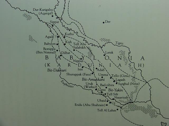
Below, Professor Saggs' map shows that _all_ of the cities of ancient Akkad and Sumer drew their water from ONE RIVER, the Euphrates and its channels. To the degree that Genesis understands ONE RIVER waters God's garden in Eden, and some Mesopotamian myths state that the gods made man to tend and till their gardens which they had planted next to their cities (built before man's creation), AND Sagg's observation that ALL the cities of Southern Mesopotamia derived their water from ONE RIVER, the Euphrates, I see the below FOUR channels or streams (dotted lines) as recalling the Edenic river dividing into four streams (Note: He shows the "modern-day course" of the Euphrates and Tigris in solid lines). The four ancient river beds of the Euphrates' channels on the below map: Stream 1: Sippar, Agade, Babylon, Borsippa, Dilbat, Isin; Stream 2: Agade, Kish, Nippur; Stream 3: Kutha, Tell Abu Salabikh, Adab; Stream 4: Kutha, Tello/Girsu, Lagash, Surghul/Nina (For the map cf. p. 181. H. W. F. Saggs. Peoples of the Past: Babylonians. Berkeley, California. University of California Press. 2000 [The Trustees of the British Museum, London]. ISBN 0-520-20222-8)
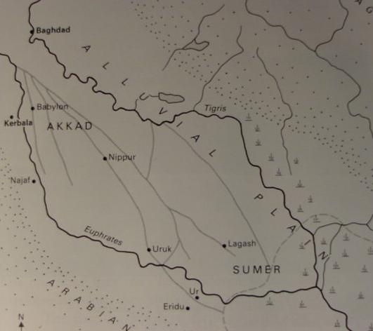
Below, a map showing the Euphrates subdividing into four streams (light gray lines) south of Baghdad (dark black lines show the present day course of the Tigris and Euphrates). According to various scholars the Euphrates in antiquity subdivided into at least three major streams, possibly as many as four streams. Perhaps Genesis' notion that a river subdivides into four heads or streams in a location called Eden is recalling the Euphrates subdividing in Lower Mesopotamia in the 6th-2nd millenniums B.C.? Professor Delitzsch, cf. above, identified Eden as being the plain of Lower Mesopotamia from Babylon to Eridu called by the Sumerians Edin. So these four streams are within Professor Delizsch's Eden/Edin (For the below map cf. p. 13, map titled: "Southern Iraq, showing the old courses of the Tigris and Euphrates." Michael Wood. Legacy: The Search For Ancient Cultures. New York. Sterling Publications. 1992). Of interest here is that Wood identifies the Garden of Eden with the city of Eridu (p. 21). He's not alone, numerous others have made the same identification, Professor H.A. Sayce in 1887, Professor T.G. Pinches in 1908, Gwendolyn Leick 2001, Manfred Dietrich 2002. I, myself, recognize Eridu as _one_ of several sites that were fused together to become Genesis' Garden of Eden (cf. below).