Map of the Crossing of the Red Sea (Yam Suph) by Israel in the Exodus (Lake Timsah)
17 November 2009
Revisions through 05 July 2010
I realize now that this article is wrong! Lake Timsah was _not_ the Red Sea Crossing point!
I will "leave the below _flawed_ research intact, however, for the "edification" of viewers (you can learn from another's mistakes).
The "problem" with Lake Et-Timsah as the Red Sea Crossing point? Maps of the 1830s through 1850s (scroll down below for such a map) note it is a "dry" lake for most of the year. Only with the Nile's annual inundation (which occurs in late June through September) does it receive any water, which would evaporate away over the rest of the year. The Nile would introduce marsh seedlings so for part of the year it probably had some marsh grasses and reeds in its evaporating pools of water. As Israel's Exodus was in the Spring (March-April), the water level at Timsah would probably be quite low or non-existent and evaporated away at this time.
Please click here for Israel's Red Sea Crossing at the Ballah Lakes near Ras el Ballah (Baal Zephon)
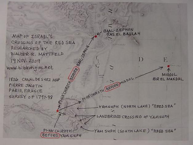
I realize now that I have been laboring for many years (over 30 years) under a "false assumption" shared apparently by all other earlier scholars (the 1800's through 2009). The 'false assumption"? That the sites for pin-pointing the crossing of the Red Sea: Baal-zephon, Migdol, Pi-ha`hiroth, Yam Suph and Etham were "very near" to each other, my research, if correct, reveals that they were not. How did the anonymous Exilic narrator come to "know" of these locations? Every single site appears to lie near or in the vicinity of a caravan route crisscrossing the Sinai from Canaan and Judah to Egypt. Apparently via Caravaneers and Traders the Jerusalem Jews came to "know" of these locations.
The below map was printed in Paris, France in 1826. French Army Cartographers did the survey in 1797-1798 when Napoleon Bonoparte conquered and briefly occupied Egypt. This map is titled "Carte topographique de l'Egypte et de plusieurs parties des pays limitrophes ... Flle. 31. Canal de Suez, en partie." It is available at the David Rumsey Historical Maps Archive on the internet. Click here to see this map which is "interactive," you can move all over its surface and zoom in and zoom out for details.
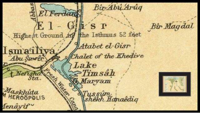
Israel after crossing the reed sea (Yam Suph) enters the wilderness of Etham or Shur, probably the desert wilderness southeast of Lake et-Timsah. Etham is for me preserved at Lake et-Timsah while Shur is preserved at the ruin site of Abu Suweir, west of Timsah on the hieghts forming the north side of Wadi Tumilat. Maps show caravan tracks to Egypt converging near Abu Suwier (1821 & 1922 maps), I suspect these tracks were called "the way to Shur" (Hebrew shuwr) from Canaan (Ge 16:7, Ex 15:22). That is to say, the caravan route to Egypt from Canaan/Judah passed by Abu Suweir and came to be called "the way to Shur that is before Egypt" and Abu Suweir is "before Egypt" ("east of Egypt").
Three days' march in the wilderness of Etham/Shur brings Israel to the waters of Marah (Ex 15:23) which were so-called because they were "bitter" (bitter in Hebrew is Marah). The Septuaginta bible (in Greek) renders Marah as Merra. I suspect Professor Heinrich Brugsh (1881) was correct in identifying the "waters of Marah" with the two Bitter Lakes in the Ishtmus south of lake et-Temsah. Hebrew mayim, "waters," is a plural form suggesting for me _two_ waters exist, the _two_ bitter lakes, today called Buhayrat Murrah. The Greco-Roman geographer Pliny noted a Lac Amari, formerly "bitter," being made into a freshwater environment with reeds and marsh grasses and migrating waterfowl in his day by the canal maintained by the Ptolemies and later the Romans. So apparently in Pliny's day Marah ("bitter") still retained its ancient name. When the French cartographers encountered it in 1797-1798 it had reverted to a salty-bitter marsh region again being deprived of the freshwaters of the Nile as the canal had fallen out of usage under the Caliphs of Egypt.
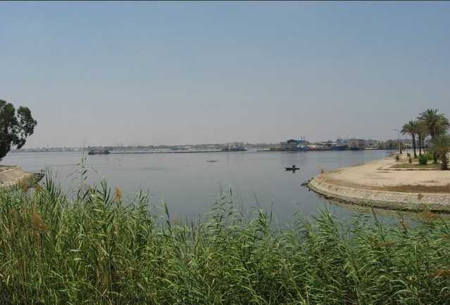
Today, 2009, Lake Timsah is still ringed by tall reeds along parts of its shore line (travel guides of the early 20th century AD commented glowingly about Timsah's lovely and graceful tall reeds lining her shores).
Below, a photo of reeds and marsh grasses lining the shore of Lake Timsah, which I understand is Yam Suph, the Reed Sea or Yam Suph:
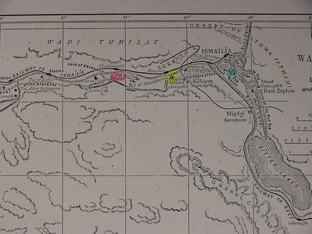
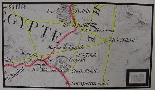
Below, the ruins of Abu Suweir (Suewer) are marked by three dots and caravan tracks cross in its vicinity to Egypt from Canaan, I understand Abu Suweir is probably biblical Shur (Hebrew: shuwr), "the way to Shur that is before Egypt" (Ge 16:7, 20:1, 25:18, Ex 15:22,1 Sam 15:7, 27:8). Bir Magdal (1821 map's Bir Makdal) is for me biblical Migdol near Yam Suph and Pi-ha-Hiroth/Pi-ha-Chiroth ( Below Map: 1922. The Times, London, John Bartholomew of Edinburgh, Cartographer).
Below, the ruin-mound of Abu Suher (Abu Suweir) my proposal for biblical Shur (map of 1864 by Carl Ritter of Germany), not very accurate in my opinion when compared to the French maps of 1821 and of 1882. This map shows work in progress on the Suez Canal under DeLesseps in the 1860s.
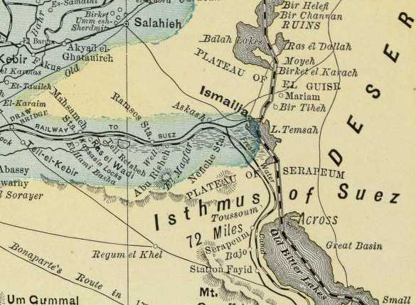
Below, map of 1897, Rand McNally of Chicago. Ras el Dallah may be a misspelling of Ras el Ballah? The route from Salahieh to Timsah (Etham?) may have been the route Israel used from Goshen (Fakus) to "Etham at the edge of the wilderness" Note the edge of the wilderness is yellowish green while the blue-green cultivated soil watered by the Nile ends near et-Timsah/Etham (Ex 13:20).
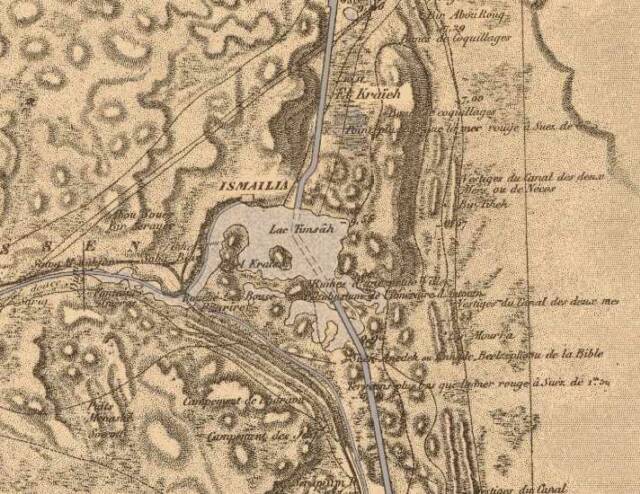
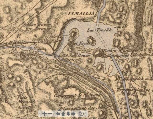
Below, the 1821 map (Pierre Jacotin, 1808) based on 1797-1798 surveys by Napoleon Bonoparte's French Cartographers. Bir Maktal on the viewer's right is for me, biblical Migdol. Baal-zephon is for me Ras el Ballah at the top of this map; Etham is Lac Temsah. Note the track going due west from Bir Makdal crossing the marsh of Karach (El Kraieh, 1882 map) to intersect with a track from Salhieh at Sabba Biar, actually near Abu Suweir, not on this map. Note the landbridge dividing Lake Timsah into two lakes, probably this is where Israel crossed Yam Suph.
I have outlined in pink marker the route taken by the French Surveyors who in 1798-1799 gathered data for the map. I have outlined in yellow marker the tracks or roads.
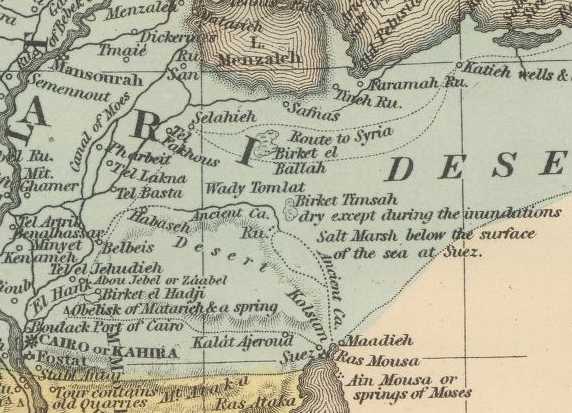
Below, map of 1859 (cartographer: Augustus Samuel Mitchell, publisher: Charles DeSilver of Philadelphia), not very accurate compared to the 1821 map, but of some help in showing two tracks to Egypt from the "Katieh wells" to Selahieh (ancient Sile of the Pharaohs' military expeditions into Syria) and Tel Faqous (my Goshen proposal). The northern track is the biblical "way to the land of the Philistines" from Selahieh while the "way to the wilderness of Yam Suph or Red Sea" passes from Selahieh to the south of the Ballah Lakes, "Birket el Ballah." Note that Birket Timsah is described on this 1859 map as _dry_ except when periodically inundated by the Nile (late June-September inundation time period). If Israel crossed the Red Sea at Lake Et-Timsah in the Spring (April-March) this lake would probably be dry or empty with no future water till the end of June thus making this an _unlikely_ site for the Crossing of the Red Sea.
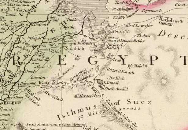
Below, map of 1844, John Arrowsmith of London. Note the caravan track from Katieh to Bir Abu Aruk passing to the south side of Birket el Ballah (today's Ballah lakes region), then becoming two tracks, the northern near Ras Ballah (not on this map) west to Salahieh, the other southwest to Saba Biar and the vicinity of Abu Suweir (not on this map). Of interest is another track from Salahieh going due south to the vicinity of Ras el Wadi (not on this map) but the west part of Wadi Tumilat where Succoth might be at Ramessdie Tell er-Retabah? Note also that this map shows the caravan route from Bir Abu Aruq (1821 Bir Abou rouq) as crossing from north to south the midst of the Birket el Karash (1821 Marais de Karach, 1882, El Kraieh, a great swampy or marshy area as is portrayed on the below map. Bir Makdal on the below map is rendered on other, later maps as Bir Magdal (cf. 1922 Map [above] The Times, London, John Bartholomew of Edinburgh, Cartographer). The track from Katieh to Saba Biar would pass just east of Abu Suweir (not on this map) north of Saba Biar, Suweir being my biblical Shur.
Click here for comments attributed to a Captain James Vetch in 1844 about Birket el Ballah and Birket el Karash receiving water from the Nile and tides at Suez versus the Mediterranean Sea:
"...the lakes of el Themsah, the Birket el Karash and, lastly, the Birket el Ballah; the last two basins are visited by the inundations of the Nile...The lake of Themsah occurs nearly in the centre of the chain of hollows above mentioned...at this place commences the wadi of Subabyar, which proceeds westerly and joins the wadi Tomilat...
(pp. 328-329. "Ship Navigation Between the Mediterranean and Red Seas." The British Friend of India Magazine. January 1844. Volume 4, number 24)
"... the tides at Suez are from five to six feet of rise and fall, but that in the bay of Tineh there are no tides, though the level of ther sea there, owing to particular winds, varies to the amount of one foot."
(p. 328. "Ship Navigation Between the Mediterranean and Red Seas." The British Friend of India Magazine. January 1844. Volume 4, number 24)
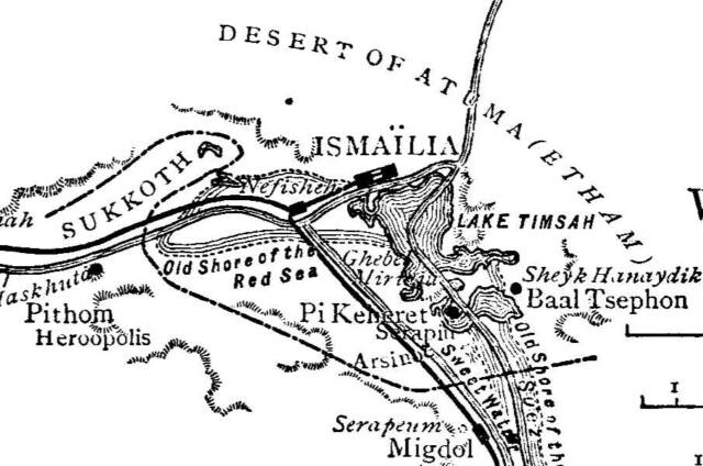
Below a slightly different map by Naville (?) showing Ptolemy II's Pi Keheret (Naville's Pi-ha-Hiroth) at the west end of the land bridge which divides Lake Timsah into two seas. Naville's earlier (?) map of 1884/5 had Baal-Tsephon (Baal-zephon) near Sheyk Hanaydik and Israel crossing the Red Sea at Migdol/Serapeum. The Pi Keheret location below, varies _considerably_ from Naville's 1884/5 map which had Pi Keheret just east of his Pithom/Heroopolis. The dotted zig-zag line is Israel's line of march, and crossing of the Red Sea at Migdol/Serapeum.
Below, 1882 map, did Israel cross the sea of reeds via the below landbridge dividing Lake Timsah into two sections? This might explain Israel's statement that she crossed on dry land and that a "wall of water" (the sea) existed on her right and left hands (Ex 14:22) alluding to the two lakes of Temsah? There is a small inlet at the east end of the landbridge allowing water from the upper lake to fill the lower lake. Nile inundations, according to 1840-1850 accounts, periodically filled up a _dry_ Birket Temseh, perhaps explaining why God "dried-up" Yam Suph, then flooded it for the Egyptians, they being caught in an unexpected Nile inundation? The below map shows a Piharirot (?) with Pharaoh's campment to its south "campment de Pharawn (Taking on an Arabic form: Faraun). This map maker apparently (?) envisioned Pi-hahiroth as on the west end of the landbridge dividing the two lakes of Timsah. Perhaps Naville's influence is in this map?
"Red Sea" is the English rendering of the Greek Septuaginta Bible's Eruthra Thalassa. The Septuaginta is believed to have been written at Alexandria, Egypt circa 275 BC by Jews. Instead of writing the Hebrew Yam (sea) Suph (Reeds) they wrote Eruthra ("Red" in Greek) Thalassa ("Sea" in Greek).
Migdol, is for me, preserved at Bir Makdal (1821, 1844, 1853 maps), Bir Magdal (1922 Map by Bartholomew of Edinburgh)
The Bible's description of the crossing of Hebrew Yam Suph (yam= sea, suph= reeds) has Israel encamped at
Pi-ha'hiroth before a sea of reeds. Pi-ha'hiroth's location is juxtaposed between Baal "of the north" (zephon) and Migdol, which I identify with Ras el Ballah and Bir Makdal, these sites appear on the track from Bir Makdal to Salhieh (1821 map) on the Delta's eastern edge. Israel left Etham at the edge of the wilderness to encamp at Pi-ha'hiroth or Pi-ha'chiroth against Yam Suph, the "Reed Sea."
Why does the Bible have God drying up Yam Suph, the Sea of Reeds? The answer: A map from 1859 (scroll down) noted that Lake Timsah (Birket Temsah) was a dry lake part of the year. It received however water from the Nile when the annual inundation or flood took place in July. The Nile would carry seedlings to be deposited in the newly laid silts at the bottom of Lake Timsah once the roiled water of the inundation had dissipated. Even to this day Lake Timsah is famed for its towering reeds lining it shores, no wonder it was called Yam Suph, the "Sea of Reeds."
Why does the Bible have the sea returning to its strength in the morning (Ex 14:27), suggesting a morning tidal action and drowning Pharaoh? The suddeness of rising water makes sense when the annual flooding of the Nile is considered as what is being recast here in the story. But the Nile does not flood every morning. At the Gulf of Suez though, in the 1840s, tides varied from 5 to 6 feet in drop and height, this could wipe out an army. The Bible places the seaports of Ezion Geber and Elath on the Gulf of Aqaba as being on Yam Suph, so apparently, in error, the Exilic narrator assumed the Reed Sea (at Timsah) extended to Edom and the tides of the Suez gulf are what caused dry land to appear and disappear. He has the wrong explanation for why dry land appeared at the Sea of Reeds which can flourish only in fresh water, not salty sea water (another fact he didn't know). It wasn't tides it was the Nile receding after the inundation and the water at Timsah eventually evaporating away. The Nile flooding would be over several weeks, the drying up over several months. No sea then "returned to its strength in the morning watch and engulfed Pharaoh's army" (Ex 14:27). We have here a confused conflation of locations (the saltwater non-reed growing Gulfs of Suez and Aqaba with Lake Timsah's freshwater reeds) along with some gross embellishment and exaggertaion of an army being wiped out in the service of biblical miracles for a naive gullible audience.
How did a Jew in the Babylonian exile know of the reed lake that dried up at times like a sebkha (a seasonal lake)? Probably via caravans that passed by Timsah enroute to Egypt via the biblical "way to Shur that is before Egypt" (Ge 25:18, Ex 15:22, 1 Sam 15:7, 27:8), the track from Beersheba past the ruins of Abu Suweir (my Shur) on the NW side of lake Timsah, said track ending at Salhieh, ancient phaohonic Sile (several tracks converge near Suweir going to Egypt from across the Sinai a srevealed on maps).
As Rameses (Qantir) is near Salhieh the latter was probably where the track to Etham and the wilderness of the Red Sea began (a track does exist some Sallhieh to Lake Timsah). Salhieh is also the southern terminus of the track the Bible calls "the way to the land of the Philistines" which although "near" at Ramses (Ex 12:37,13:17), Israel did not use for fear of war with the Philistines who would not let them cross their land (Gaza) to get to Jerusalem.
So, Israel, at Salhieh (?) instead of taking the quicker northern track to Philsta and Canaan via Qantara bypassing the north side of Birket Ballah, takes the longer "way to the wilderness of the Red Sea," (Ex 13:18) Hebrew: Yam Suph (Lake et-Timsah), the southerly track from Salhieh/Sile towards Etham, preserved in Lake et-Timsah (1821, map) at the east end of Wadi Tumilat. When Israel "turns about" from Etham to encamp at Pi-ha'hiroth she has, for me,"turned" back from the southeast side of Lake Timsah to encamp before it on its west side by Gebel el `Keir, perhaps by marching to the NW circumventing the north shore of Lake Timsah.
It is interesting that Israel upon embarking upon the way to the wilderness of the Red Sea is described as armed and ready for battle (Ex 13:18) as it was from ancient Egyptian Sile that Egyptians left Egypt's border (the Delta edge being Egypt's border) armed for battle to conquer Canaan and Syria, just as Israel was to eventually conquer Canaan. That is to say Sile/Salhieh is the jumping off place for the military conquest of Canaan by both Egyptians and the Hebrews.
A second caravan route from Salhieh takes one to the northside of Wadi Tumilat and the vicinity of Sabba Biar (1821 map) and nearby Abu Suweir (on the 1922 map of Bartholomew, Edinburgh). This is probably the track Israel used to go to Etham from Rameses and Goshen/Faqus (Ex 13:17-20).
I understand, in agreement with Professor Kitchen (an Egyptologist), that Etham is probably preserved in the vicinity of Lake Timsah (Birket et-Temsah, now Bahr at-Timsah). An 1859 map description of the area stated that Temseh was a _dry_ lake (see below for this map) but with the annual inundation of the Nile it received flood waters becoming for a brief time a water-filled small lake or birket. The Nile's waters would bring reed grass seedlings to birket et-Temsah giving it stands of reeds and marsh grasses from the Delta. Today (2009) Lake Timsah still has tall reeds growing along parts of its shore line brought in by freshwaters from the Nile via Wadi Tumilat and the Suez Canal and Lake Menzaleh, a bay at the mouth of the Nile.
After leaving Rameses, Egyptian Pi-Rameses or Per-Rameses (modern Qantir and nearby tell ed-Daba), Israel camps at Succoth. Naville in the 1880's excavated at Tell Maskutah in Wadi Tumilat and found a stela there erected by Ptolemy II (reigned circa 275 BC) honoring the god Tum "of the land of Tjeku," which he argued was Hebrew Succoth. Ptolemy II dedicated a new temple "in Heroopolis" (Greek polis means "city of" Heroo, maybe the Egyptain god Heru, Greek Horus?) called Pikerehet and provided revenues for its upkeep. Several scholars have suggested Succoth might be preserved in Arabic Maskutah, ma="place of" skutah= "the idol," referring in the 1850's to a large stone statute of three Egyptian deities seated next to each other: Pharoah Rameses II being between Heru, and Tum. Sand had buried it to its waist and they faced the east and the rising sun (Heru [Hor-em-khet] and Tum were aspects of the sun rise in the east and Pharaoh was called "son of the sun" and "the sun"). It was excavated in the 1860's and is in a museum today at Ismaila at Lake Timsah. At Maskutah a silver bowl was found dedicated to the Arabic goddess Elat in Persian times, perhaps Wadi Tumilat is a later fusion of these two gods' names: Tum and Elat?
More recent excavations in the 1980s revealed Tell el Maskutah was founded by Pharaoh Necho II circa 610 BC, as it had no Ramesside pottery, only a few Hyksos tombs and Necho's Saitic pottery then Persian, Ptolemaic Greek and Roman pottery. Apparently Necho barged in by ship earlier and very heavy Ramesside monuments to adorn his new port on the canal he was building to link the Nile to the Gulf of Suez via Wadi Tumilat. I understand Genesis-2 Kings to be a linear history ending circa 562-560 BC in the Exile in Babylonia as its last datable statement is 2 Kings 25;27, mentioning Evil-Merodach the king of Babylon who reigning at that time (he was assassinated by 560 BC). So, Maskutah (Ptolemy's god Tum of Tjeku = Succoth and Necho might have had an Egyptian Pikheret shrine (?) at his port of Heroopolis, all could have existed by 610 BC to become part of the Exodus itinerary of 562-560 BC.
Naville (1880s) suggested that the new temple of Pi Kerehet/Pi Keheret that Ptolemy II (circa 275 BC?) visited to dedicate and provide revenues for its maintenance may recall in some way the biblical Pi-ha-Hiroth (others' Pi-ha-Chiroth).
Some theories on Pi-ha'hiroth's meaning as an Egyptian or Hebrew word:
"The theory of an Egyptian etymology was advanced by Jablonsky, who compared it to the Coptic "pi-akirot"= "the place where sedge grows" (The Jewish Encyclopedia, on-line, citing Hasting's Dictionary of the Bible).
"Pi-hahiroth, "the place where the reeds grow." (Bible Encyclopedia at Christian Answers.net)
If Naville is correct that the Ptolemaic temple of Pi Kerehet/Pi Keheret in Heroopolis is connected in some way to Pi-ha'chiroth then the Hebrew might be a false explanation of an Egyptian word into Hebrew?
The Bible says Pi-ha`Chiroth is by: (1) a sea (yam) which has (2) muck to clog chariot wheels, (3) it is subject to drying up, (4) it has reeds (suph), and it is associated in some way with places called Migdol and Baal of the north (zephon). I find some match-ups here on the 1821 and 1826 maps which were based on 1797-1798 cartographic surveys.
Why is Israel able to cross the Yam Suph on dry land but Pharaoh's chariot wheels are bogged down in muck or sediment of the marsh-like reed sea?
The Lakes at Temsah (there are two) in the 1840s dried up part of year, they became lakes apparently (?) with the July inundation of the Nile.
When they were mucky, from evaporated water, no one could walk across them, nor could wheeled vehicles like wagons or chariots cross either. A fact that would be known by Caravaneers who passed these lakes enroute to Egypt from Canaan and Judah. So the muck of Lake Temsah becomes Pharaoh's chariot wheels being bogged down.
Moses' sister Miriam breaks out in song praising God for drowning Pharaoh's host in the waters of Yam Suph, the Sea of Reeds (Ex 15:20-21). Could perhaps Miriam be preserved at the site of Gebal Maryam (Naville's Serapeum) on the south side of Lake Timsah (I don't know how old this name is unfortunately) a site known to Caravaneers which was to be later recast into Miriam?
An English sea captain noted that in the 1840s tides at Suez could vary in height from 5 to 6 feet (now this would drown Pharaoh's army!). Maps of Suez in the 1850's before the Suez Canal was built reveal extensive sand shoals existed at low tide which when covered in a high tide would overwhelm an army.
Apparently the Exilic author of 562-560 BC has fused morning tides in the Gulf of Suez with annual Nile inundations at Lake Timsah. After crossing Yam Suph (Nu 33:8), then 3 days in the wilderness of Etham (Nu 33:8), Marah (Nu 33:8), Elim (Nu 33:9), the Red Sea (Nu 33:10), the wilderness of Sin (Nu 33:11), so for him, Yam Suph extended about 5 days from the initial crossing. Still later he has Ezion Geber and Elat on the Red Sea, the Gulf of Aqaba. So several locations over thousands of miles are being embraced under the term Red Sea. Reeds grow only in fresh water, which lake Timsah fulfills, they don't grow in the Gulf of Suez or Aqaba (they could grow "near" the shores of these two gulfs if fresh water exists from wadies or catchment pools for rain like sebkhas.
The Bible has Yam Suph identified later with Ezion Geber on the Gulf of Aqaba, so Professor Kitchen maybe right, the whole area from the Ballah Lakes, Birket Karash, Birket Timsah, the Bitter Lakes, the Gulfs of Suez and Aqaba were all conflated into one great sea, in error, by the 562-560 BC Exilic narrator in Babylonia.
Foster, a Professor of Biblical Literature at Yale (1914) on Lake Timsah being most probably the site for the crossing of the Red Sea by Israel via its landbridge which he calls a narrow strait a quarter of mile wide (I agree; I found this on the internet on 19 Nov. 2009):
"The significant term, Sea of Reeds, points not to the Red Sea, in whose waters reeds would not thrive, but to the marshy shores of Crocodile Lake, the modern Lake Timsah...Into it poured fresh waters from the Nile...Lake Timsah is still surrounded by a thicket of vegetation. Inasmuch as the Hebrews frequently used the word sea (for example, the Sea of Galilee) as the designation of an inland lake, the name Sea of Reeds was exceedingly appropriate.
Probability that the passage was at Lake Timsah. According to the earliest biblical narrative deliverance came to the Hebrews as they were pursued by the Egyptians because "Jehovah caused the sea to go back, by a strong east wind all the night, and made the bed of the sea dry." The shallow south-eastern end of Lake Timsah satisfies most fully the physical conditions implied by this ancient narrative. At its southern end it opens out into a broad bay, but between this point and the main body of the lake was a shallow, marshy strait, not more than a quarter of a mile across. A strong wind driving it from the level desert would force back the waters into other parts of the lake, leaving this passage comparitively dry. A close and significant parallel is recorded by Major-General Tulloch, who states that the shallow waters of Lake Menzaleh, which lies only a short distance to the north and is subject to the same conditions, were driven back by the wind for seven miles, leaving the bottom of the lake dry (Journal of the Victorian Institute, Vol. XXVIII, p. 267, and V?ol. XXVI, p. 12). The biblical narrative also states that "Jehovah bound the chariot wheels of the Egyptians so that they proceeded with difficulty." This is precisely what would follow, not on a hard, sandy shore, but in the marshy, muddy waters of a body of fresh water like Lake Timsah...the southeastern end of Lake Timsah is the most probable site."
(pp. 113-114. Charles Foster Kent. Biblical Geography and History. New York. Charles Scribner's and Sons. 1914, 1926) My note: The Suez Canal of 1865 changed considerably Timsah's water topography. Foster, 1914, apparently was _unaware_ of the landbridge separating Timsah into two lakes or bays appearing on maps made between 1821-1860, and thus thought, in error, an east wind had swept water away from a submerged narrow strait! However, that such could happen at Lake Menzaleh suggests the Exilic narrator of 562-560 BC probably transposed such phenomenon observed and reported by Caravaneers following the trade route skirting the east shore of Lake Menzaleh at Qantara to Salhieh (Pharohonic Sile), to the Sea of Reeds at Temsah to explain the dry land dividing a sea in half.
Below, the 1821 map of Egypt showing a track going due west from Bir Maktal to Bir Abou rouq, Ras el Ballah, and Salhieh on the Egyptian Delta. The second track going due west from Bir Maktal crosses the southern end of Marais de Karach, "the marsh" of Karach, it intersects a track from Salhieh at Abu Suweir (not on this map) and continues to Ras el Wadi at the west end of Wadi Tumilat. Lac Temsah is south of the track crossing Marais de Karach. For me Bir Maktal is Migdol, Baal-zephon (Baal of the north) is Ras el Ballah, "north" of Lac Temsah (modern Bahr et-Timsah).
Please click here for the on-line interactive version of the below map which allows you to move about all over the map and zoom in and zoom out of various locations at the David Rumsey Historical Maps Archive.
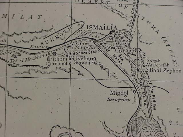
Below, Naville (1884/1885) places Pi-ha'hiroth, his Ptolemaic Pi Keheret, just east of Pithom/Heroopolis which he identifies with biblical Pithom and biblical Succoth (Heroopolis is also called Tell el Maskhutah and Abou Kachab). To have Pi-ha'hiroth closer to the shore of the Red Sea he extends the sea to the vicinity of Tell el Maskhutah and his Pi Keheret (the name appears as a temple in Heroopolis on the Ptolemy II stela found by him) several miles west of the current boundary of Lake Timsah. He gives the wilderness of Etham as Egyptian Atuma, read by other Egyptologists "Edom" which he disagrees with, in the Anastasi Papyrus ( Edouard Naville. The Store-city of Pithom and the Route of the Exodus. 1885. 2nd edition. London. Egypt Explorartion Fund). From this map it does not appear that he identified the land bridge dividing Lake Timsah into two lakes being the dry land Israel marched over. He also places Clusma (Clysma) and Arsinoe near Heroopolis in wadi Tumilat whereas other scholars suggest that are near the present day port of Suez. The curving line embracing Sukkoth (biblical Succoth) and biblical Migdol near the Serapeum, is his proposal for Israel's line of march, he having Israel cross the Red Sea near the Migdol/Serapeum.
It seems to me that the Exodus' various locations and their phenomena, strong east winds, sea water being pushed away to expose land, a sea of reeds, muck, Baal-zephon, Migdol, Etham, Shur, Marah, Elim, are all based on observations made by Carvaneers or Traders plying their trade goods between Jerusalem and Egypt.
They used at least three routes (probably more) and each route provides a jigsaw puzzle piece: elements that were fused together to create the Exodus story. The Exilic narrator of 562-560 BC merely conflated these places and phenomena occuring near different caravaan routes into one location, Yam Suph, the Sea of Reeds and the Exodus Route.
Trade Route One:
From Salhieh, Egypt to Phista, Canaan and Judah, the biblical "way to the land of the Philistines." A strong wind pushes back sea water exposing land from Lake Menzalah's shoals as noted by Foster in 1914. Quail yearly alight in thousands on Mediteranean Sea beaches near the trade route near El Arish (feeding Israel upon leaving Egypt).
Trade Route Two:
From Salhieh and Bubastis, Egypt via wady Tumilat, Bir Abu Suweir (biblical Shur) and Lake Temsah (Sea of Reeds with its landbridge creating two bays, drying up periodically then filling with fresh water and reed seedlings via annual Nile inundations). Marah being the Bitter Lakes, Arabic Murra. The Caravan track from Katieh (Way of the Philistines) via Ras el Ballah (Baal Zephon) to et-Timsah (wilderness of Etham), Abu Suweir west of Timsah (wilderness of Shur). Wady Tumilat/Temsah can be reached via Katieh (Way of the Philistines) or from Beersheba, Qusaima (the biblical "way to Shur," Abu Suweir west of Timsah) via Negev station of Halatsa and thence to Bir Hasanna in the Sinai, thence to Lake Timsah and Suweir/Shur from whence one can go to either Salhieh or Bubastis.
Trade Route Three:
On/Heliopolis (Cairo area) via Suez, from Beersheba and Qusaima in the Negev. Stories of strong winds from the east blowing back seawater near Suez port (ancient Roman Clysma). High tides in morning drowing Pharaoh's army, is the Suez 5 to 6 foot tides on submerged then exposed shoals at Suez. Nearby Ayun Musa being recast as Elim.
Trade Route Four:
Tjeku (Succoth, Tell el Maskutah, Wadi Tumilat) Egypt to Serabit el Khadim in the Sinai and its mines of copper and Turquoise. Inscriptions found at Serabit el Khadim mention miners or masons from Tjeku. From Wadi Tumilat: Succoth (Tjeku), Etham (lake Timsah, Bahr et-Timsah), the waters of Marah (the two Bitter Lakes), Elim (Ayun Musa), wilderness of Sin (Hosan abu Zenna near Wadi Gharandal). Israel's worship of the Golden Calf (Golden Hathor, cow goddess honored at Serabit el Khadim). Moses shattered 10 commandments (shattered proto-sinaitic inscriptions at Serabit el Kahdim mines, at base of mountains). Mount Sinai (Gebel Saniya at Serabit el Khadim), Paran, Wadi Feiran east of Serabit el Khadim.
I can reached for comments or questions regarding the research presented here by clicking here.
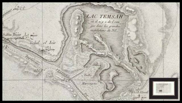
Gebel el `Keir is to the west of the river channel from Wadi Tumilat that provides fresh water from the Nile at the time of the July Nile inundation or flood which fills the basins or lakes of Timsah as is somewhat noted in French text under the words Lac Temsah: "Lac Temsah eu il a' y a de l eau que dans les grandes inondations du Nil".
I understand Israel's encampment at Pi-Ha`Chiroth was just to the NE of Gebel el `Keir. Israel crossed the dried up river (?) "mouth" (Hebrew: pi-) from Wadi Tumilat and Saba Biar. That is to say Pi-ha`Chiroth, "the mouth of `Chiroth," is this river mouth or channel below the east slope of Gebal el `Keir, which provides fresh water from Nile to Lake Timsah. After crossing the seasonal dried-up river mouth below Gebel el `Keir Israel now walked across the great landbridge or strait extending from west to east dividing Lake Timsah up into two major bays. The biblical text says that as Israel walked on the dry land of Yam Suph she could see a "wall of water" on her right hand and another "wall of water" on her left hand (Exodus 14:22). On her left hand as she walked east on this landbridge or strait was the northern bay, on her right hand was the southern bay each apparently described as a "wall of water." Pharoah's chariot wheels were caught-up in the mucky sediments of the sebkha lake's bottom when God sent a flood to drown him and his army (this destruction of Pharaoh's army in a flood is imagined nonsense for me). The notion that God dried up Yam Suph for Israel to cross in an allusion to the physical phenomenon that Lake Timsah fills with water only at the time of the Nile's inundation or great flood in late July. The rest of the year the water evaporates away or is absorbed into the watertable creating a great marsh with marsh grasses and reeds, said plants being replenished each July as seedlings are brought down by the Nile via Wadi Tumilat to settle in the newly laid Nile mud silts collecting at Lake Timsah's bottom. The below map has marsh grasses and reeds (?) lining the shores of the various lakes, hence its Hebrew name Yam Suph, the "Sea of Reeds" (yam=sea, suph= reeds). Please click here to access the interactive version of the below map and zoom in or zoom out on its various features. Gebel el `Keir, for me, preserves Hebrew `Chir[oth] (Pi-ha`chiroth, Pi-ha`hiroth). The pi- or "mouth" ha (of) is the mouth of the river below the eastern slopes of Gebel el `Keir, that provides fresh water from the Nile to fill Lake Timsah during the annual inundation in July. Israel camped by Gebel el `Keir, "before" Pi-ha`Chiroth, the river-mouth of Wadi Tumilat.
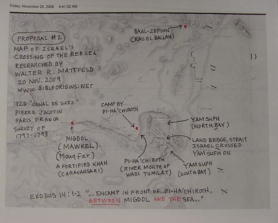
Proposal Two for Migdol's location (20 November 2009):
One of my problems is in determing which English translation of the Hebrew text is "correct." The below RSV substitutes "before" Migdol with "between" Migdol and the Sea and instead of "before" Baal-zephon, in "front" of Baal-zephon:
Thus the RSV rendering of Exodus 14:1-2 suggests that Pi-ha'Chiroth is between Migdol and the sea, a statement not supported in proposal one (above). Perhaps Migdol, west of Pi-ha`Chiroth (?) is the fortified Caravansari site of Mawkel (alternately called Mouqfar)?
"...encamp in front of Pi-ha-hi`roth, between Migdol and the sea, in front of Baal-ze'phon; you shall encamp over against it, by the sea."
Proposal 3 for Migdol's location (20 Nov. 2009):
I understand that the Primary History, Genesis-2 Kings was, in its "last form" put together in the Exile between 562-560 BC, during the reign of the Neo-Babylonian king Amel-Marduk, biblical Evil-Merodach of 2 Kings 25:27. Pharaoh Necho (reigned: 610-595 BC) is credited with building a canal from the Nile to Red Sea, a project he did not complete. Excavations in the 1980s at Abou Keychab (Tell el Maskhutah) revealed no Ramesside pottery, the site had however Saitic pottery of Necho's period, then Persian, Greek, Roman, and Arabic potsherds. A Roman inscription in Latin identified the site in three words, one above the other in a column: "Polis Ero Castra" with a palm branch under the last word (plate 11 fig. A. Edouard Naville. The Store-City of Pithom and the Route of the Exodus. London. Egypt Exploration Fund. 1885. 2nd edition). Castro means "fort." Perhaps Necho "fortified" this "port" too? If he did, then the Migdol west of Pi-ha`chiroth might be an allusion to Necho's fortified port of Heru (Heru being the Egyptian form of Greek Horus. Perhaps Heru became Greek Heroo, polis, the city of Heru? Necho's reign, 610-595 BC _antedates_ the final form of the Primary History, Genesis-2 Kings of 562-560 BC and thus the Migdol west of Pi-ha`chiroth "might" be an allusion to Necho's fortified port as migdol is a Semitic word for a fort. Another possible fort or migdol is further west, at Tell er-Retabah which has Ramesside pottery. So a migdol west of Pi-ha`Chiroth could be an allusion either to the Ramesside fort (?) at Tell er-Retabah or a Saitic fortified port (?) of the Saitic pharaoh Necho at Heroopolis.
Below, Naville's 1884-5 map. The blue marker is the location of Gebel el`Keir from the 1826 Jacotin map (not on Naville's map) where I locate Pi-ha`Chiroth. The yellow marker is the site of Abou Keychab (also called Tell el Maskhutah & Heroopolis) and the pink marker is Tell er-Retabah a Ramesside settlement. Either Necho's fortified (?) port (?) of Heru (?) to protect his canal, or Ramesside er Retabah "might" be the Migdol west of Pi-ha`Chiroth (Pi-ha`Hiroth). Naville had Israel crossing the Red Sea at the Serapeum and proposed it was the Exodus' Migdol; the
"zig-zag" line on the map (Sukkoth to Serapeum) being Israel's route of travel to the Red Sea shore (He has Pi-hahiroth or Ptolemaic Pi Keheret just east of Tell el Maskhutah [yellow marker] which is for him Heroopolis and Pithom).
Proposal One (19 November 2009):
I understand the Hebrew word translated "before" or "east of" is referring to Baal Zephon (Ras el Ballah) "before" Pi-Ha'Chirot at Gebel `Keir, west of Lake Temsah, `Keir being the Arabic version of Hebrew `Chir [-oth]. Migdol "before" Pi-Ha`Chiroth is Bir el Makdal (Bir Magdal on the 1922 John Bartholomew map for the London Times Atlas). This map was discovered by me just today, 19 Nov. 2009, and I am very excited about it, as it is the only map I have encountered showing Gebel `Keir, which for me, preserves `Chir of Pi-ha`Chiroth (others' Pi-Ha`hiroth).
The New American Standard Bible (1995), Exodus 14:1-2, 9
"They journeyed from Etham and turned back to Pi-ha'hiroth, which faces Baal-zephon, and they camped before Migdol."
King James Version:
"And they removed from Etham, and turned again unto Pihahiroth, which is before Baal-zephon, and they pitched before Migdol."