The Land of Goshen (Ancient Egyptian Pa-qas, Greek Phacusa, modern Faqus)
01 July 2004 (Revised 31 Aug 2004)
Please click here for this website's most important article: Why the Bible Cannot be the Word of God.
For Christians visiting this website my most important article is: The Reception of God's Holy Spirit: How the Hebrew Prophets _contradict_ Christianity's Teachings. Please click here.
Scholars are divided as to where the land of Goshen lies. Some, following statements in the Septuaginta, a Greek translation of the Hebrew Bible believed to have been made in the 3rd century B.C., think Goshen, rendered Gesem in Greek, is Wadi Tumilat, more particularly its west end, including the Delta lands from the Nile near Zagazig and Bubastis to the western mouth of the wadi; this was the understanding of Professor Naville in the 1880's who did excavations at Saft el Henna (near the western mouth of the wadi) and at Tell el-Maskhutah in Wadi Tumilat. He found a shrine at Saft el-Henna (Ancient Egyptian Per-Sopt) mentioning a "land of Kes" which for him was Goshen (I note that the Latin Vulgate calls it Gessen). He also thought Tell el-Maskhutah was Pithom, because of Ramesside statues found there and the account of the pilgrimess Egeria and the Septuagint bible. He also found at the site two Latin inscriptions mentioning Hero and one inscription mentioned a "Hero Castra" (Castra is Latin for Fort), Hero being a Roman shortened form of Greek Heroopolis (polis meaning "city"), and noted that the Septuagint suggested that Heroopolis was in the land of Goshen/Gesem. Still later, in Roman times (4th-6th century A.D.), a pilgrimess from either Spain or France variously rendered Silvia, Etheria or Egeria, mentioned Heroopolis as a Roman fort or settlement in a region which could only be today's Wadi Tumilat. She also located Rameses in this same valley just west of Heroopolis. So Naville's excavations caused him to understand that Heroopolis was Tell el-Maskhutah and Egeria's Pithom, and Goshen was "Kes" mentioned at Saft el-Henna, and thus drew a map of Goshen as extending from Bubastis to Wadi Tumilat.
The problem? Naville's excavations in the 1880's were overturned by later re-excavations in the 1980's at various locations in Wadi Tumilat. Holladay's excavations at Tell el-Maskhutah revealed that no Ramesside pottery debris existed anywhere on the site. It had debris of the Hyksos era, mid 16th century B.C., a period of a long abandonment, then resettlement in the Saitic era under Pharaoh Necho ca. 610 B.C. who was building a canal to the Red Sea via the Wadi, and Persian, Ptolemaic and Roman debris. The ONLY Ramesside pottery debris was at Tell er-Retabeh to the west of Tell el-Maskhutah. Holladay suggested that the Ramesside statuary found earlier by Naville at Maskhutah was barged in on Necho's canal from Retabeh to adorn his new port. Holladay, on the basis of his findings, still thinks that Maskhutah is biblical Pithom (as suggested by Naville), but that the fact it is no earlier than 610 B.C. is a marker for him that the biblical account was composed quite late. Other scholars have disagreed and suggest Pithom is at Retabeh because it has the required Ramesside debris.
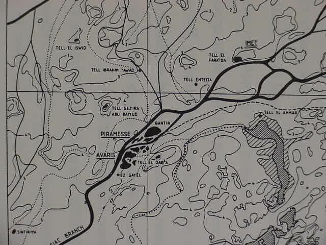
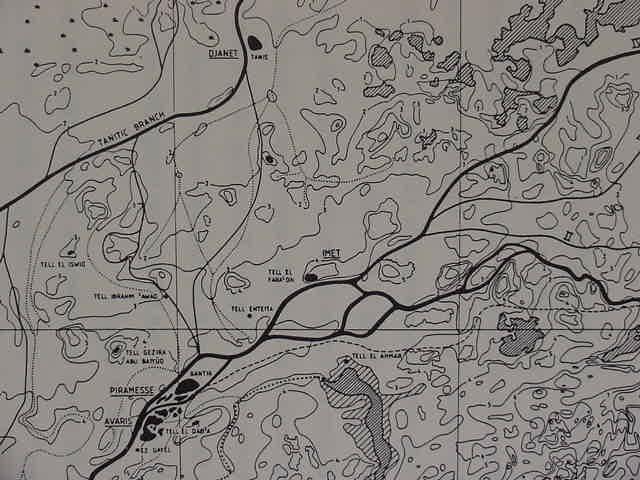
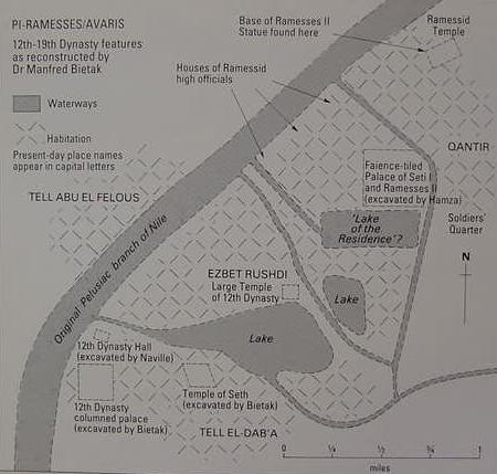
Today many scholars have rejected Etheria's identification of Rameses as being in Wadi Tumilat. Based on excavations at modern Qantir, this location is now understood to be Rameses (Egyptian Pi-Ramesses).
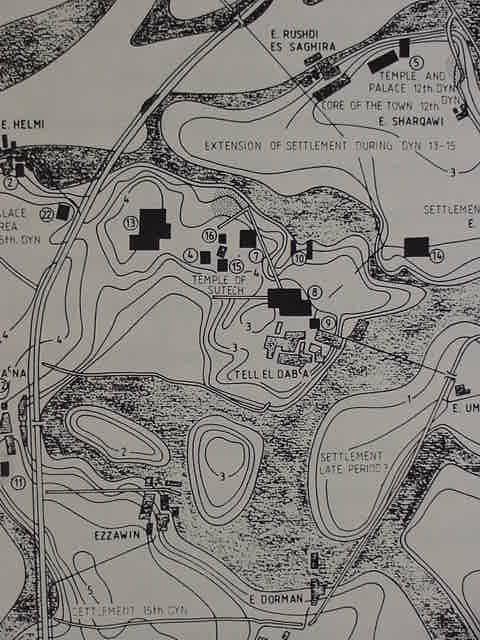
The 3rd century B.C. Egyptian historian, Manetho, wrote a history of Egypt for his Ptolemaic overlord in Greek and this was used by the 1st century A.D. Jewish historian Flavius Josephus to "prove" the antiquity of his people. Josephus associated Manetho's Hyksos expulsion from a city called Avaris with the biblical Exodus. Today based on excavations, Avaris is understood to be modern Tell el-Dab'a, adjacent to Qantir, (ancient Pi-Ramesses). According to Wilson, Qantir and Daba'a are so close to each other that it is possible that in Ramesside times Avaris became a suburb of Pi-Ramesses, biblical Rameses. This would explain why Manetho's Avaris came to be renamed Rameses in the Bible.
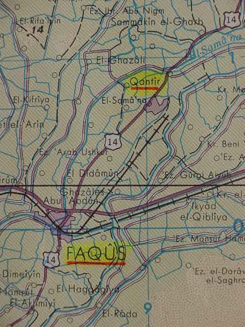
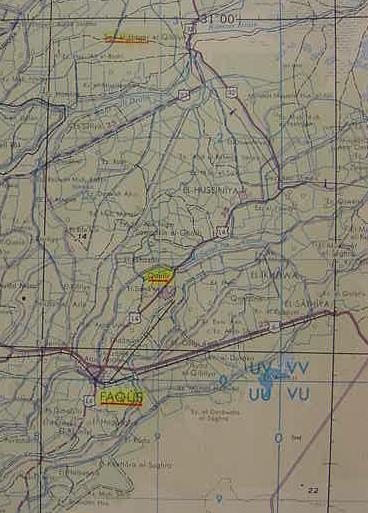
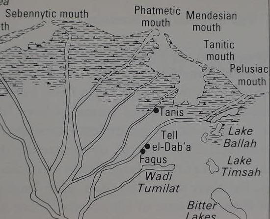
_IF_ the archaeologists are correct that Tell el-Dab'a is Avaris and Qantir is Rameses, and _IF_ Manetho and Josephus are correct in identifying the Exodus as from Avaris, then it appears to me that "the land of Goshen" _has to be_ in the immediate vicinity of these two locations, NOT in Wadi Tumilat, as suggested by the Septuagint and Etheria. Today, Dab'a and Qantir are in the "Faqus District," a district named after the town of Faqus, just 7 kilometers (approximately 4 miles), south of Tell el-Dab'a. I suspect that Faqus may have been rendered in ancient Egyptian as Pa-Qus ("Domain of Qus"? Herodotus mentioned a Patamus which some suggest is Pithom), and that this word probably preserves the word Goshen.
Conder on the possible origins of the word Goshen, preserved perhaps in Faqus (Emphasis mine):
GOSHEN (1)
go'-shen (goshen; Gesem):
1. Meaning of Name:
The region where the Hebrews dwelt in Egypt. If the Septuagint reading Gesem be correct, the word, which in its Hebrew form has no known meaning, may mean "cultivated"--comparing the Arabic root jashima, "to labor." Egyptologists have suggested a connection with the Egyptian word qas, meaning "inundated land" because Goshen was apparently the same region, called by the Greeks the "Arabian nome," which had its capital at Phakousa representing the Egyptian Pa-qas (Brugsch, Geog., I, 298), the name of a town, with the determinative for "pouring forth." Van der Hardt, indeed, more than a century ago (see Sayce, Higher Criticism, 235), supposed the two words to be connected. Dr. Naville in 1887 found the word as denoting the vicinity of Pi-sopt (now Saft el Henneh), 6 miles East of Zagazig--in the form Q-s-m. He concludes that this was the site of Phakousa, but the latter is usually placed at Tell el Faqus, about 15 miles South of ZOAN (which see), and this appears to be the situation of the "City of Arabia" which Silvia, about 385 A.D., identifies with Gesse or Goshen; for she reached it in her journey from Heroopolis, through Goshen to Tathnis or Taphnis (Daphnai), and to Pelusium.
2. Situation:
It is generally agreed that Goshen was the region East of the Bubastic branch of the Nile; and in Ps 78:12,43, it seems to be clearly identified with the "field (or pastoral plain) of Zoan," which was probably also the "land of Rameses" mentioned (Ge 47:11) as possessed by Jacob's family (see RAAMSES; ZOAN). Where first mentioned (Ge 45:10), Goshen is promised by Joseph to Jacob as a land fit for flocks, and the Septuagint here reads, "Gesem of Arabia," probably referring to the Arabian nome which took its name from the "desert" which defended the East border of Egypt. In the second notice (Ge 46:28 f), the boundary of the land of Goshen, where Joseph met his father, is called in the Septuagint Heroo(n)-polis, and also (Ge 46:28) "the land of Ramesse(s)"; so that in the 3rd century BC Goshen seems to have been identified with the whole region of the Arabian nome, as far South as Heroopolis which (see PITHOM) lay in Wady Tumeilat. Goshen included pastoral lands (Ge 46:34; 47:1,4,6,27; 50:8) and was still inhabited by the Hebrews at the time of the Exodus (Ex 8:22; 9:26), after which it is unnoticed in the Old Testament. The name, however, applied to other places which were probably "cultivated" lands, including a region in the South of Palestine (Jos 10:41; 11:16), "all the country of Goshen Septuagint Gosom), even unto Gibeon," and a city of Judah (Jos 15:51) in the mountains near Beersheba. These notices seem to show that the word is not of Egyptian origin.
3. Description:
The region thus very clearly indicated was not of any great extent, having an area of only about 900 square miles, including two very different districts. The western half, immediately East of the Bubastic branch of the Nile, stretches from Zoan to Bubastis (at both of which cities records of the Hyksos ruler Apepi have been found), or a distance of about 35 miles North and South. This region is an irrigated plain which is still considered to include some of the best land in Egypt. The description of the land of Rameses (see RAAMSES), in the 14th century BC, shows its fertility; and Silvia says that the land of Goshen was 16 miles from Heroopolis, and that she traveled for two days in it "through vineyards, and balsam plantations, and orchards, and tilled fields, and gardens." The region narrows from about 15 miles near the seashore to about 10 miles between Zagazig and Tell el Kebir on the Southeast of this, a sandy and gravelly desert lies between the Nile plain and the Suez Canal, broadening southward from near Daphnai (Tell Defeneh) to Wady Tumilat, where it is 40 miles across East and West. South of this valley an equally waterless desert stretches to Suez, and from the Bitter Lakes on the East to the vicinity of Heliopolis (Southeast of Cairo) on the West. Thus, Wady Tumeilat, which is fertilized by the Nile waters (see PI-HAHIROTH), and contains villages and corn fields, is the only natural route for a people driving with their flocks and herds by which the vicinity of the Red Sea can be reached, the road leading from the South end of the "field of Zoan" near Bubastis, and 40 miles eastward to the "edge of the wilderness" (see ETHAM) and the head of the Bitter Lakes. This physical conformation is important in relation to the route of the Israelites (see EXODUS); and Wady Tumeilat may very possibly be intended to be included in Goshen, as the Septuagint translators supposed.
C. R. Conder
Ward covers the various scholarly proposals for Goshen, which I do not want to re-hash here, I am interested in focusing in on the arguments for Faqus preserving Goshen (Emphasis mine):
"There has been a long debate over the precise location of the Egyptian Goshen. In the LXX [Septuagint], Goshen is rendered as Gesem or Gesem Arabia (Gen 45:10; 46:34). Arabia was used by Herodotus to refer to the area from the Nile to the Red Sea, and more specifically, by Pliny and Ptolemy the Geographer, to designate the 20th Lower Egyptian nome, or administrative district (Helck 1975:197-98). This nome, attested first in Egyptian texts of the 8th century BCE lay on the border of the eastern delta in the region of modern Faqus and Saft el-Hinna. Faqus is ancient Phacusa, which, according to Ptolemy, was the capital of the Egyptian nome, and Saft el-Hinna preserves the ancient name Pr-Spdw, "Domain of (the god) Spodu," the Egyptian term for the 20th Lower Egyptian nome...The precise location of Goshen of the Hebrew text remains problematic. The basic requirement for Jacob and his family was pasturage for their herds; the general region of the Eastern Delta fits this admirably. Egyptian texts speak of the other Canaanites moving into that area for precisely this reason...The biblical references clearly indicate that the Hebrews settled within Egypt, and the story of Moses and the bulrushes (Ex 2:3-0) shows they lived along the Nile in proximity to the royal family and its official residence. Furthermore, the phrase "in the land of Goshen" of the P-source is replaced in the J-source by "in the land of Ramesses" (Ge 47:11). Hebrew tradition evidently considered "Goshen" and "Ramesses" to be the same place, bringing into focus the claim that the Hebrews engaged in building activities at the cities of Ramesses and Pithom (Ex 1:11).
The city called Pr-R'mssw-mry-'Imn, "Domain of Ramesses, beloved of Amon," or sometimes simply "Ramesses," was the royal residence city of the empire built on the site of the old Hyksos capital Avaris (Bietak LA 5:128-46). There is little doubt that it is to this city that the biblical narrative refers. While founded earlier than the period of Ramesses II, the royal residence city came to be associated mostly with him; hence its name. Over the past decades, the city has been identified with many Delta sites, though it now seems certain that it was located at Tell el-Dab'a/Qantir, 7 kilometers [4 miles] North of modern Faqus, thus within the region later designated as Arabia, the 20th Egyptian nome...The evidence at hand suggests that the "land of Goshen" was located in the Eastern Egyptian Delta in the general region of modern Faqus, Saft el-Hinna, and Tell el-Dab'a/Qantir. In Egyptian, this region was known as the "Domain of Sopdu," the 20th Lower Egyptian nome..." (pp. 1076-1077. Vol. 2. William A. Ward. "Goshen." David Noel Freedman, editor. The Anchor Bible Dictionary. Doubleday. New York. 1992)
Albright on Goshen and G and Q in Egyptian:
"But, in general, the Hebrews lived in the north-easternmost part of Egypt, in the region called in the Bible variously the 'land of Rameses', i.e., the region around Tanis-Pira'masese (Gen 47:11), the 'plain of Tanis' (Psalm 78:12, 43, from the tenth century BC), and Goshen (a Semitic name referring apparently to a certain kind of soil)." (p. 155. William Foxwell Albright. Yahweh and the Gods of Canaan, A Historical Analysis of Two Contrasting Faiths. [The Jordan Lectures 1965 Delivered at the school of Oriental and African Studies, University of London]. Winona Lake, Indiana. Eisenbrauns. 1994 reprint of 1968).
In a footnote to the term Goshen Albright observed :
"The initial voiced g was impossible in Egyptian, as we know from extensive phonological evidence, e.g., Semitic g was transcribed as q or k in Egyptian, and Egyptian g appears as q in Semitic. Goshen appears several times as a South-Palestinian place-name, and Hebrew gus (Aramaic gusa) is a word for soil of some kind (cf. also Gus-halab= Gischala in Galilee). (p. 155. Note 8. William Foxwell Albright. Yahweh and the Gods of Canaan, A Historical Analysis of Two Contrasting Faiths. [The Jordan Lectures 1965 Delivered at the school of Oriental and African Studies, University of London]. Winona Lake, Indiana. Eisenbrauns. 1994 reprint of 1968). Note: Albright's "gus" has a diacritical over the s which renders the pronunciation as sh.
Tvedtnes has noted that the Hebrew word ending or suffix "-on" freqently appears in placenames (called toponyms in the scholarly literature), observing that Shomron means "Shemer's PLACE" and he mentions other similar examples like Gibeon, Ashkelon, etc.(cf. the exchange of views on the meaning of the word "Shomron" amongst John A. Tvedtnes [Brigham Young University], Juan Manuel Tebes [Fellow, Albright Institute] and Eveline J. van der Steen [Leiden, the Netherlands] on the Ancient Near Eastern Discussion list hosted by the University of Chicago, 22-27 October 2004 )
Herodotus knew of a place called Patumus, sometimes equated with the biblical Pithom. Some have proposed that Pithom preserves the Egyptian article pi as a shortened form of per, meaning "house of" or "estate of" [the god] Tum (alternately rendered Atum from ancient Egyptian 'itm). Egyptian inscriptions mention a Piramesses/Pr-Ramesses, equated by some with biblical Rameses. So perhaps pi and pa may mean "estate" or "house" of Qus, which the Hebrews transformed into Gosh-en "place of Gosh," ancient Egyptian Pa-Qus, modern Faqus?
Below, a map showing Qantir, believed to be biblical Rameses and Faqus, which I understand to preserve the name Goshen (Ismailia. United Arab Republic. Scale : 1:250,00. Sheet NH 36-6. 1970. Washington DC.
Budge understands that Hebrew Goshen may be (?) related to Egyptian Qesem, the capital of the Sept nome, said capital being rendered in Greek as Phaccusa, and preserved in Egyptian Coptic as kws (cf. Vol. 2. p. 1045, column a. "Qesem." E. A. Wallis Budge. An Egyptian Hieroglyphic Dictionary. New York. Dover Publications. [1920] reprint 1978)
Finegan mentions that Pharoah Ramesses I (ca. 1295-1294 B.C.) before coming to the throne, bore the name Peramesse, which he translates as "Pa-Ramses, the Ramses" (cf. p. 234. Jack Finegan. Handbook of Biblical Chronology. Peabody, Massachusetts. Hendrickson Publishers. 1964, 1998, Revised Edition).
Is it possible that modern-day Fakus near Tell el-Dab'a and Qantir (Avaris and Rameses), was originally Pa-Qus, "the Qus"? Was Qesem perhaps rather Qusem (?), the "m" becoming "n" (?), Pa-Qusem, Pa-Qusen, Goshen?
However, Naville in the 1880's found an ancient Egyptian 30th Dynasty shrine erected by Pharaoh Nectanebos, ca. 380-362 B.C. at Saft el Henneh which he argued was ancient Pa-Sopt, and that an inscription on the shrine mentioning the land of Kes or Qes, was referring to the Septuaginta's Gesem, the Masoretic text's Goshen (cf. Edouard Naville. The Shrine of Saft el Henneh and the Land of Goshen.1885. The Egypt Exploration Fund. London)
Naville noted that the Classical Geographer Ptolemy had stated that in his day Phacusa was the metropolis "mother-city" (or capital) of the nome of Arabia, and that it was later called Phaguse on the Romano-Byzantine Peutinger Map and by the annonymous "Geographer of Ravenna." Also that Phacusa was a Christian Episcopal See of Egypt in Romano-Byzantine times (p.15. Naville).
Noting that several scholars associated Phacusa with modern Fakus (his Fakoos), he set out to demonstrate that this was not possible and that Saft el-Henneh "ought" to be Phacusa (pp. 15-16. Naville).
He noted with approval that Egyptian "pa" was either the definite article ("the"), or "house," or "temple," citing work by Brugsch and Ebers (p. 16. Naville). Naville argued that Coptic KWS derived from Greek Phacussa, could be rendered into the KES of the Saft el-Henna shrine, noting though, that he could not find anywhere a PA KES rendering on the shrine (p.16. Naville).
As I have noted earlier, above, if Tell el-Dab'a is Avaris and if Qantir is Rameses of the Bible, then the land of Goshen ought to be nearby, and Faqus is nearby. So I will have to reject Naville's argument that KES is Coptic KWS, and opt here for Faqus being Goshen, and Ptolemy's Phacusa.
Naville did mention in passing however that there was an ancient Egyptian city called Pkes, but that no-one knew of its location, and he suggested perhaps Faqus might be this city (p. 16. Naville).
I guess it would be quite easy to confirm if Ptolemy's Phacusa is Faqus. I would assume that an archaeological inspection of the location ought to turn up remains of a Romano-Byzantine church confirming it was a Episcopal See and it ought to also have earlier debris of Ptolemy's world.
Now if Saft el Henneh also has remains of Ptolemy's world and a Romano-Byzantine church then the situation becomes murkier. But I would still opt for Faqus being Goshen because of its nearness to Qantir (Rameses?), and San el Hagar (Zoan?).