Professor Potts has recently challenged (1997) the commonly encountered scholarly perception that a "vast sea" once extended from near Ur and Eridu to the Persian Gulf in the 6th-2nd millenniums B.C. He understands that several ancient sites with traces of _irrigated fields_ found near the Hawr al Hammar Lagoon existed in the 2nd millennium B.C. and that they would have been "underwater" had such a vast sea actually existed.
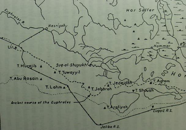
He argues that these sites were strung-out in a line paralleling the Euphrates river south of the lagoon (today the Euphrates is north of the Lagoon). If he is right, then this may explain the "mystery" of Dilmun being sited near a "river" in a marshland environment. In one myth Enki is portrayed as espying maidens standing on the bank of a river in the midst of the marshlands. When he attempts sex, one maid cries out "no man take me in the marshes." Over time a succession of maidens appear at the river's bank and are accosted by Enki, who is said to glide down a river through the marshes to the bank which is described as being at Dilmun! The Euphrates presence in the marshlands east of Ur and Eridu, if rightly argued by Potts, would seem to align "Dilmun's river" in a marsh environment with any of the 2d millennium B.C. sites south of the present-day Hawr al-Hammar Lagoon. One of these sites is Tel al-Lahm, which is shown as being connected to the Euphrates via the Id-Nun canal which begins at Ur (cf. map figure 1.12. p. 28. D.T. Potts. Mesopotamian Civilization: The Material Foundations. Ithaca, New York. Cornell University Press. 1997). Potts (map figure 1.17, p. 37) shows the boundary of lands inundated by the Tigris and Euphrates rivers and this line passes to the south of Tell al-Lahm, so this site lies within the so-called "Sealands," the marshes and lagoons east of Ur and Eridu. The presence of irrigated fields at some of the sites south of the Hawr al-Hammar Lagoon reveals that apparently there existed sizable patches of land near these sites, they were not simply tiny islands in the midst of the marshes. In fact Potts has argued that the Hawr al-Hammar may be a recent phenomenon, coming into existence about 1870 (cf. pp. 36-41).
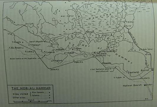
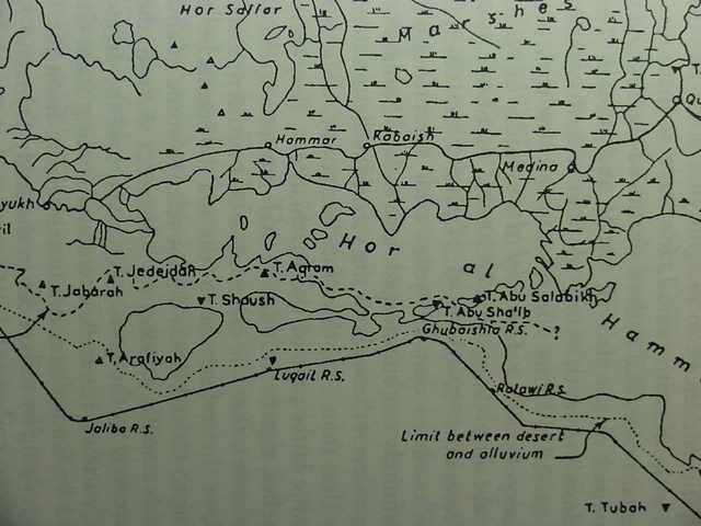
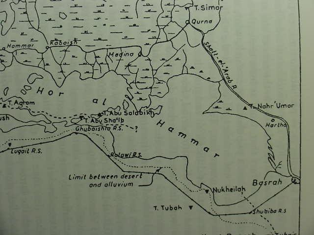
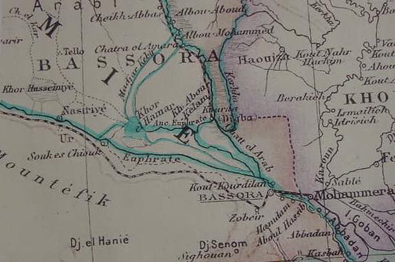
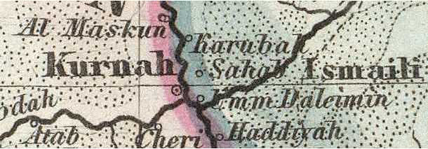
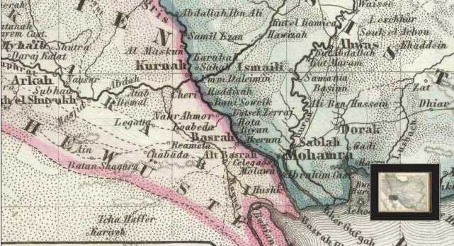
The above map by G. Roux (1960) shows pre-Islamic archaeological sites (2d millennium B.C.) in the vicinity of the Hor al-Hammar Lagoon from the vicinity of Ur to Basra. Dilmun might be one of these sites?
Potts (1997) on Georges Roux's discoveries (1960) near the Hor al-Hammar Lagoon:
"In cuneiform sources southernmost Mesopotamia was known as mat tamti(m) (Sumerian KUR A.AB.BA), the 'Sealand'...While B. Meissner could claim in 1920 that the lack of mounds in this region made it certain that it had been under water (Meissner 1920:4), G. Roux's survey of the Hor al-Hammar (fig. 1.17) showed that this was purely the result of insufficient exploration (Roux 1960:30), for there is in fact a string of mounds 'extending in an almost straight line from Tell Lahm to a point 23 miles north of Basrah' which, Roux suggests 'provides a strong argument against the classical theory according to which the whole of this region was under sea-water from prehistoric times to the dawn of the Christian era' (Roux 1960:30). The existence of sites such as Tells Kirbasi, al-Lahm, Aqram and Abu Salabikh in the area of the modern Hor al-Hammar underscores the fact that, from at least the early second millennium B.C. onwards, this was a populated area which, while it may have been marshy, was certainly not submerged beneath the Gulf. Rising no more than 2 meters above the water line, Tell Kirbasi is today periodically surrounded by water, yet it is difficult to imagine that a site like this was located on an island in the Kassite period, for there is little reason to suppose that if this were the case, Tell Kirbasi or indeed the Sealand generally would have been cited as a source of cattle and cereals. Thus, de Morgan's suggested shoreline in the time of Sennacherib would place under water sites such as Tell al-Lahm which we now know were occupied during the Neo-Assyrian period! The discovery of a cylinder of Nabonidus (555-539 B.C.) at Tell al-Lahm...moreover, confirms that 150 years after Sennacherib's time, the region was most definitely not submerged, and indeed Sanlaville's sea-level curve shows that sea-levels throughout the second millennium B.C. were only marginally higher (less than 1 meter) than they are today, while from the Neo-Assyrian through the latter part of the Parthian era, they were, contrary to de Morgan's belief, significantly lower than modern levels.
That is not to say, however, that the entire area of southernmost Mesopotamia was dry land, or that references to 'the sea' in Sennacherib's account or in texts relating to Ur and Eridu do not refer to some inland body or bodies of water which actually existed...more recently Adams has suggested, 'We may have to deal in in the past, as to a lesser extent we still do today, not with a well-defined shoreline but with a progression of swamps and more and more open, more brackish or saline lagoons' (Adams 1981:16). Nevertheless, this does not necessarily mean that the Hor al-Hammar itself existed when the sites found by Roux were inhabitated. As Roux himself remarked, the existence of relict canals near Tell Abu Salabikh and a well at Tell Aqram suggest that this region was once cultivated, as indeed the Kassite cuneiform sources cited above confirm, and drier than it is today." (pp. 37-38. Potts)
"Finally, had the Gulf actually reached the area of Ur, Eridu or Tello, one must ask whether these sites could have then existed. W. Nutzel has noted that the tidal pattern in the northern Gulf affects the waters of the Shatt al-Arab in that salt-waters enters it at least as far as Abdul Khasib, circa 10 kilometers east of Basra. The interchange of salt and sweet water would have made irrigation from such water impossible, for none of the staple cereals grown in antiquity would have been able to tolerate water with such a high salt content. Therefore, settlements must always have been situated outside the zone affected by such an interchange. The very existence of sites like Ur, or for that matter, the mounds discussed above in the Hor al-Hammar district, Nutzel argues, precludes the possibility that salt-water was present in close proximity to them (Nutzel 1980:98-9)."
(p. 39. D. T. Potts. Mesopotamian Civilization: The Material Foundations. Ithaca, New York. Cornell University Press. 1997)
Professor Jacobsen's below translation of an ancient text describing Enki's seduction of Dilmun's maidens at a _riverbank _in_ Dilmun_, in the midst of a _marshland_ seems _to me_ to "align" with Roux's above map showing the Euphrates river snaking its way through the marshlands past several 2nd millennium B.C. settlements.
The late Professor Jacobsen on Dilmun's "riverbank" and "river-quays" or "river-docks" for ships, noting that the "setting" for the story appears to be the marshlands of Lower Mesopotamia, _not_ the islands of Bahrain and Failaka or the desert wildrness wastes of eastern Arabia from Kuwait to Bahrain which have no river or marshes:
"Enki...He brings fresh water underground from the Euphrates at the Sumerian port of Izin and has it fill the large footprints made by the sun god as he steps from Dilmun up into heaven, much as footprints in marshy ground will fill up with water...Dilmun; for the scene of the second story is most naturally seen as the marshes in southern Mesopotamia."
(p. 182. "Enki and Ninsikila/Ninhursaga." pp. 181-204. Thorkild Jacobsen. The Harps That Once...Sumerian Poetry in Translation. New Haven & London. Yale University Press. 1987)
"Izin has not yet been identified. The mention of bollards indicates that it was a harbor city, and the fact that Dilmun's fresh water came from there suggests a position on the Euphrates, perhaps near the outlet, where the river looses itself in the sea and could have been thought to have gone underground." (note 4. p. 182. Jacobsen)
"In Sumerian mythical geography Dilmun lay at sunrise, which is how it conceivably looked to an observer from the mainland west of it. The Sun god was traditionally assumed to step up into heaven over two mountains." (note 5. p. 182. Jacobsen)
Jacobsen's translation suggests, for me, that Dilmun is associated with Sumer:
"Pure is the city-
and you are the ones
to whom it is allotted!
Pure is Dilmun land!
Pure is Sumer-
and you are the ones
to whom it is alloted!
Pure is Dilmun land!"
(p. 185. "Enki and Ninsikila/Ninhursaga." pp. 181-204. Thorkild Jacobsen. The Harps That Once...Sumerian Poetry in Translation. New Haven & London. Yale University Press. 1987)
Enki attempts to impregnate Nintur, in an environment of canebreaks and marshland (which does not resemble the islands of Failaka and Bahrein), but rather the marshes of Lower Mesopotamia:
"Enki the wise one,
toward Nintur,
the country's mother,
was digging his phallus
into the levee,
plunging his phallus into the canebreak.
The august one, for her part,
pulled his phallus aside
and cried out:
"No man take me
in the marsh!"
(p. 191. "Enki and Ninsikila/Ninhursaga." pp. 181-204. Thorkild Jacobsen. The Harps That Once...Sumerian Poetry in Translation. New Haven & London. Yale University Press. 1987)
Enki spies a sequence of maidens over several years from a marsh, gets in his boat, and with a favorable wind behind him glides downstream through the marshes to accost them as they stand by a river bank. All this suggests to me that the marshlands near Eridu, Enki's principal residence, are downstream from the nearby Euphrates river whose mouth deposits silts into the marine estuary called a "sea" in the ancient hymns. The fact that these maidens are _in_ Dilmun, at a river's bank when seen "upriver" by Enki in his boat, suggests that Dilmun is very near Eridu and is probably Tell el Lahm, NOT the island of Failaka or Bahrein in the Persian Gulf. Also of interest is Jacobsen's mention of Dilmun's "riverquays" or river docks for boats.
"You have given a city, [Dilmun]
What avails me your giving?
[A city] that has no river [quay!]"
(p. 187. "Enki and Ninsikila/Ninhursaga." pp. 181-204. Thorkild Jacobsen. The Harps That Once...Sumerian Poetry in Translation. New Haven & London. Yale University Press. 1987)
In turn Ninkurra
[went out on the riverbank;]
Enki was able to see up there
from in the marsh...
His page Isimu
replied to him:..
with a favorable
downstream wind
blowing for my master
he has put his one foot
in the boat,
may he not stay the other on dry land!
He clasped her to the bosom,
kissed her,
Enki poured
semen into the womb...
(pp. 193-194. "Enki and Ninsikila/Ninhursaga." pp. 181-204. Thorkild Jacobsen. The Harps That Once...Sumerian Poetry in Translation. New Haven & London. Yale University Press. 1987)
Nin-imma in turn [went out]
on the riverbank;
Enki was towing (his boat)
up from the marsh
and was able to see up there,
he laid eyes on Nin-imma
on the riverbank,
and to his page Isimu
he said:
One like the nice youngster
should I not kiss?...
His page Isimu
replied to him:
A (favorable) downstream wind
is blowing for my master,
a downstream wind
is blowing!
You have put one foot
in the boat,
put the other up there
like the first one."
He clasped her to the bosom..."
(pp. 195-196. "Enki and Ninsikila/Ninhursaga." pp. 181-204. Thorkild Jacobsen. The Harps That Once...Sumerian Poetry in Translation. New Haven & London. Yale University Press. 1987)
Langdon on Dilmun:
"...Dilmun. This is the well known land mentioned in historical texts...it lay on the shores of the Persian Gulf and has been located by the writer and others on the eastern shore...Dilmun must have included Eridu at the mouth of the Euphrates in mythology and Dilmun was the Sumerian land and garden of Paradise."
(pp. 193-194. Stephen Herbert Langdon. The Mythology of All Races, Semitic. Vol. 5. Boston. Archaeological Institute of America. Marshall Jones Company. 1931)
"Here again, there seems to be a confusion of sources, for Gilgamesh's journey with the boatman across the western sea to find Utnapishtim as related in tablets nine and ten cannot be reconciled with the location of the "land of the blessed" at the mouth of the rivers in tablet eleven, or the Flood story. The "mouth of the rivers" is surely taken from the old Sumerian legend in which Ziusudra was translated to Dilmun. Obviously some island at the mouth of the Tigris and Euphrates is meant here." (pp. 223-224. Langdon)
Pinches on Eridu being "between" the "mouths of the rivers":
"(In) Eridu a dark vine grew, it
was made in a glorious place,
Its appearance (as) Lapis-lazuli, planted beside
the Abyss,
Which is Ae's [Ea's/Enki's] path, filling Eridu with fertility...
In its interior is the sun god Tammuz.
Between the mouths of the rivers (which are) on both sides.' "
(p. 71. Theophilus G. Pinches. The Old Testament in the Light of the Historical Records of Assyria and Babylon. London. The Society For Promoting Christian Knowledge. 1908 3rd edition)
I note that Eridu (Sumerian Eridug) in antiquity was "between" two mouths of the Euphrates, the Eridug Canal WSW of the city and the Purattum and Iturungal Canal bypassing the northside of Ur, heading for Tell el Lahm as the Id-Nun Canal (cf. the above map). Note: the Sumerian word id can mean either "canal" or "river." In myths the Igigi gods dug the channels of the Tigris and Euphrates as well as the canals branching off them to deliver water to the gods' city gardens in edin. As ancient texts state Eridu was at the edge of the "Sea", the Euphrates' mouth would have been nearby. Dilmun would lie in the "Sea" east of the Euphrates' mouth. East of Eridu is Tell el Lahm. On the northside of Tell el Lahm the Euphrates canal (Id-Nun) passes by. Is this canal the "riverbank" that the maidens of Dilmun stood on when Enki drifted "downstream" in his boat with a wind to his back from the marsh, to seduce them ?
Langdon noted that a hymn to the Sumerian moon-god Nannar or Nanna (Akkadian Sin) portrays him as associated somehow with a temple called Shagnamsar (e-sag-nam-sar kur Dilmun-na) in Dilmun (note: the diacritical mark over the first s in Sagnamsar renders "sh"). Note: kur can be rendered "mountain," "land," "region," and "underworld." There is _no_ mountain at Ur, so a kur Dilmun at Ur would suggest a region or land of Dilmun at Ur:
"In the temple Shagnamsar which
is in the mount of Dilmun (kur Dilmun-na)
In the temple of the holy stylus
a shepherd I caused to be (?).
First son of Enlil, in the land
he is ruler, glorious hero,
far famed shepherd.
In the meadow a sanctuary I
built: in the abode of my city Ur,
In the temple Shagnamsar which
is in the mount of Dilmun (e-sag-nam-sar kur Dilmun-na)
In the temple of the holy stylus
a shephed I have caused to be (?).
It is a sagar melody
Song on the flute to Sin."
(p. 279. Lines 14-22. "Liturgical Hymn to Sin." Stephen Herbert Langdon. Sumerian Liturgies and Psalms. Philadelphia. University of Pennsylvania. University Museum. Publications of the Babylonian Section. Vol. X. No. 4. 1919)
Are my eyes "deceiving me," is Dilmun being equated with Ur, the residence of the moon-god, Sumerian Nannar or Nanna (Akkadian Sin)? The mouth of the Euphrates in antiquity was near Ur and Eridu and both cities were understood to be at the "edge of the sea" (3rd millennium B.C. texts).
Losch (2005) on Ur being a port-city at the "mouth" of the Euphrates in antiquity:
"When it was in its prime, Ur was a major port on the mouth of the Euphrates, very close to the Persian Gulf. Over millennia the gulf coast has moved back and the Euphrates has shifted its course, flowing about ten miles east of the now inland ruins of the city."
(p. 243. "Ur of the Chaldees." Richard R. Losch. The Uttermost Part of the Earth: A Guide to Places in the Bible. William B. Eerdmans Publishing Company. 2005)
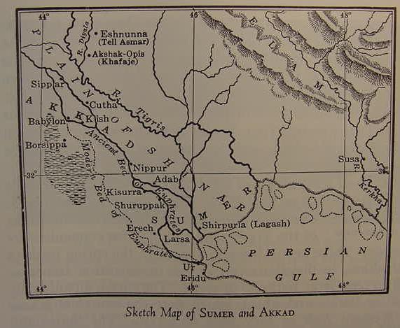
Below: A map (1916/1963) showing _in error_ the "shore" of the Persian Gulf at or near Ur of the Chaldees and Eridu suggesting they are port cities. (cf. p. 141. "Sketch Map of Sumer and Akkad." James Henry Breasted. Ancient Times, a History of the Early World. Boston. Ginn & Co. 1916, 1963 Second Revised Edition)
Conclusions:
Professor Potts, reflecting modern professional scholars' opinions, understands the land of Dilmun was at first the northeastern shore of Arabia from near modern Kuwait to the vicinity of Modern Bahrain and that later Dilmun "migrated" to the island of Bahrain and still later embraced the island of Failaka east of Kuwait. The problem? These locations do not "align" with Professor Jacobsen's above description of Dilmun possessing river quays and its maidens being accosted on the banks of river in a marshland setting by Enki of Eridu.
Archaeologists have also failed to find evidence of a city in any of the above locations (the eastern shore of Saudi Arabia, and the islands of Bahrein and Failaka) associated with Dilmun appearing in texts of the late 4th through early 3rd millenniums B.C. The earliest city or settlement of any size in this region according to Hojlund is Qal'at al Bahrain on the island of Bahrain which dates no earlier than circa 2200 B.C. Yet Dilmun appears in Sumerian texts from circa 3200 B.C. through 2300 B.C. It would appear that professional scholars have settled on a "phantom" Dilmun which did not exist as a city or settlement for nearly a thousand years, 3200-2300 B.C., Qal'at al Bahrain coming into existence circa 2200 B.C.
If I am understanding Hojlund rightly, he seems to be saying _no_settlements_ existed in the eastern littoral of Arabia (where Dilmun allegedly was "first located" according to Potts) or at Bahrain before circa 2200 B.C. yet Dilmun appears in Sumerian texts from circa 3200-2300 B.C!
"The largest archaeological site in Bahrain is the tell of Qal'at al-Bahrain, on the north coast of the main island...The earliest remains of human occupation found at Qal'at al-Bahrain date back to circa 2200 B.C. and were located by the northern side of the tell facing the sea. This small settlement is the only one from this period in Bahrain and, indeed, in all of eastern Arabia. The finds show subsistence at that time already relied on a fully developed oasis agriculture with palm trees and cereal cultivation in the nearby fields, supplemented by herding of cattle, sheep and goats and by fishing."
(p. 59. Flemming Hojlund. "Qal'at al-Bahrain in the Bronze Age." Harriet Crawford & Michael Rice, editors. Traces of Paradise, the Archaeology of Bahrain, 2500 B.C -300 A.D. London. Published by the Dilmun Committee for an exhibit from the Bahrain National Museum. Printed June 2000)
I have attempted to argue that the professional scholars are in error. The sites they have chosen for Dilmun _do not_ match the geographical setting appearing in texts describing Dilmun: a settlement on a river in a marshland setting. Most interesting for me was Professor Jacobsen's observation that the setting for Enki's seduction of Dilmun's maidens appears to be the marshlands of Lower Mesopotamia and I am in agreement with his observation which appears to have been "overlooked" or "ignored" by professional scholars who advocate Dilmun is to be associated with Bahrein and/or Failaka:
"Enki...He brings fresh water underground from the Euphrates at the Sumerian port of Izin and has it fill the large footprints made by the sun god as he steps from Dilmun up into heaven, much as footprints in marshy ground will fill up with water...Dilmun; for the scene of the second story is most naturally seen as the marshes in southern Mesopotamia."
(p. 182. "Enki and Ninsikila/Ninhursaga." pp. 181-204. Thorkild Jacobsen. The Harps That Once...Sumerian Poetry in Translation. New Haven & London. Yale University Press. 1987)
I understand Dilmun is probably to be found in the marshlands, the mat tamti or mat tamtim "the sea-land" or "sea-lands" between Sumer and Elam and near the ancient course of the Euphrates river as it wound its way though this area as noted on Roux's map of this area. The "sea" that Dilmun lay in the midst of was _not_ the Persian Gulf, it was the "sea-land" east of Ur and Eridu and west of Elam.
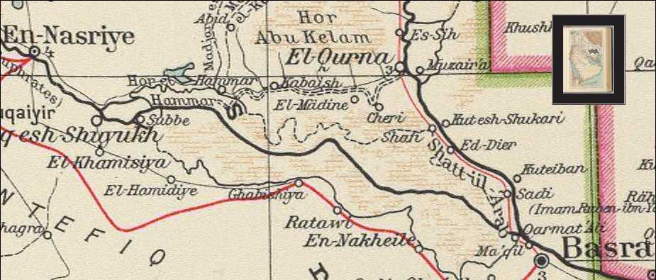
Only if archaeological remains dating from the late 4th millennium B.C. (Dilmun being mentioned in texts found at Uruk from circa 3200 B.C.) and extending to the time of Nabonidus (the 6th century B.C.) are found will the site's identity be established. Wherever the site is, it should be near a river in a marshland setting and "near" the "mouth of the rivers," near the mouth of the Euphrates or just east this mouth. Could Umm Daleimin at the mouth of the rivers, the mouth of the Tigris and Euphrates at Qurnah be Dilmun? An archaeological investigation needs to be done of the Umm Daleimin area to verify if there is an ancient overlooked tell that might be Dilmun. Click here for satellite photos suggesting just such a tell might exist here.
Bibliography:
James Henry Breasted. p. 141. "Sketch Map of Sumer and Akkad." Ancient Times, a History of the Early World. Boston. Ginn & Co. 1916, 1963 Second Revised Edition.
Flemming Hojlund. "Qal'at al-Bahrain in the Bronze Age." p. 59. Harriet Crawford & Michael Rice, editors. Traces of Paradise, the Archaeology of Bahrain, 2500 B.C -300 A.D. London. Published by the Dilmun Committee for an exhibit from the Bahrain National Museum. Printed June 2000.
Thorkild Jacobsen."Enki and Ninsikila/Ninhursaga." pp. 181-204. Thorkild Jacobsen. The Harps That Once...Sumerian Poetry in Translation. New Haven & London. Yale University Press. 1987.
Stephen Herbert Langdon. p. 279. Lines 14-22. "Liturgical Hymn to Sin." Sumerian Liturgies and Psalms. Philadelphia. University of Pennsylvania. University Museum. Publications of the Babylonian Section. Vol. X. No. 4. 1919.
Stephen Herbert Langdon. The Mythology of All Races, Semitic. Vol. 5. Boston. Archaeological Institute of America. Marshall Jones Company. 1931.
Richard R. Losch. The Uttermost Part of the Earth: A Guide to Places in the Bible. William B. Eerdmans Publishing Company. 2005.
Theophilus G. Pinches. The Old Testament in the Light of the Historical Records of Assyria and Babylon. London. The Society For Promoting Christian Knowledge. 1908 3rd edition.
D. T. Potts. Mesopotamian Civilization: The Material Foundations. Ithaca, New York. Cornell University Press. 1997.