Sumerian Dilmun is Umm Daleimin by Qurnah?
13 December 2009 (Revisions through 16 July 2011)
Click here for why Bahrain cannot be Dilmun.
The issue before us is whether or not the 30 beru to Dilmun is 300+ miles or 132 miles. If it is the latter, then Dilmun _cannot_ be the island of Bahrain (favored by most scholars), it is more likely to be found somewhere in the marshes east of ancient Sumer between Ur and the mouth of the Shatt al Arab, called in antiquity the Sea Land.
Regarding the above distance of "thirty beru" to Dilmun: This appears to be a unit of measurement for distance as traveled by a land army. The Reallexicon der Assyriologie suggests that the distance of 30 beru is approximately 220 kilometers (roughly 132 miles). Is the 30 beru to Dilmun then 220 km (132 miles)? Note: Aphek and Raphia are known to archaeologists, they lie near the Mediterranean Sea, Raphia is west of Israel.
"In Esarhaddon's account of a march from Aphek to Raphia (Borger, As. 112f.), the distance (probably rounded to the nearest 0 or 5) is given as 30 beru. Direct distance: c. 220 km, thus beru is 7.3+ km. A similar account gives 6 beru as the distance of Ashurbanipal's march from Damascus to a town called Hululityu, which, if correctly identified with a ruin c. 50 km to the south, leads to 8.3 km for the beru...Sparse evidence from the marching patterns of the Assyrian army suggests that 2 beru was the normal day's march...This corresponds roughly to the marching practices of the Roman army, for which the normal march (iter justum) was c. 20 km...The length of the danna/baru therefore corresponded roughly to 2 parsangs or 60 Greek stadia..."
(p. 467. Vol. 7. Erich Ebeling, Bruno Meissner, et. al. Reallexikon der Assyriologie und Vorderasiatischen Archaologie. Berlin & New York. Walter de Gruyter Publishing House. 1987-1990. A 16 Volume work)
Using calipers I set them to a map scale of 220 km and noted that this is "roughly" the distance from ancient Eridu and Ur near modern an-Nasiriyah to the mouth of the Shatt al-Arab where it empties into the Persian Gulf. I note that in 1881 Professor Friedrich Delitzsch (Leipzig) _also_ located Dilmun in this same general location suggesting it was probably buried under sediments near the ancient mouth of the Shatt al-Arab. Please click here and scroll down for his map (1881) and Dilmun. Note: The distance from mouth of the Shatt al-Arab to Bahrain which is currently favored to be Dilmun is roughly 440 kms, the equivalent 60+ beru (if Esarhaddon's 30 beru is 220 km). Please also note that ancient texts speak of Eridu and Ur as near the "shore of a sea," and marshlands could be called a "sea." So, Dilmun is in a marshland or "sea" and was reachable from Ur/Eridu in that it was only 220 km/132 miles east of these cities.
Crawford, who believes Bahrain is Dilmun (400+ miles from ancient Sumer), seems to suggest that the 30 beru to Dilmun was calculated from the border of Sumer. I have noted texts suggests Ur was at the shore of a "sea," the Tamti marshes (emphasis mine):
"Much later, Sargon II of Assyria describes Dilmun as lying thirty beru from Sumer, in the middle of the sea...This confirms the information gathered from the earlier documents suggesting that some or all of the territory of Dilmun was an island. As a beru is usually thought to have been a measure of time equivalent to two hours, it provides us with an approximate travelling time from Mesopotamia...this distance of 300 miles would fit well."
(p. 2. Harriet E. W. Crawford. Dilmun and Its Gulf Neighbours. Cambridge University Press. 1998. 1st Edition)
Professor Kitchen on 30 beru and Dilmun's location, who reckons the distance from the mouth of the Euphrates or Shatt al Arab (?) rather than from Sumer's border at Ur (emphasis mine):
"A generation earlier, Sargon II claimed receipt of gifts in submission from Uperi, king of Dilmun, whose hideout was located -like a fish- 30 beru distant, amidst the Sea of the Rising Sun." As the phrase "Sea of the Rising Sun" is merely a synonym (like "Bitter Sea") for the Lower Sea, and the comparison with a fish expresses island status, these reinforce the data of Assurbanipal...The distance of 30 beru may provisionally be taken as reckoned from sailing clear of Mesopotamia's coastline, in practice from the mouth of the Euphrates; it may readily be taken as the sailing-time between there and Dilmun, as several writers have clearly pointed out. The figure agrees well with the 300 miles or so from the mouth of the Euphrates to Bahrain. By the same token, it excludes both Failaka (much too near to the Euphrates' mouth) and Qeshm (much too far away)."
(pp. 39-40. "Dilmun." Kenneth Anderson Kitchen. Documentation For Ancient Arabia. Part One. Chronological Framework and Historical Sources. [The World of Ancient Arabia Series] Liverpool, United Kingdom. Liverpool University Press. 1994)
Pritchard's translation suggests for me that Dilmun lies within the "sea-lands" and that it was quite a feat for any monarch to enter and subdue the tribes dwelling in this land who could "ambush" their 'land-lubber' enemies and easily "hideout" in the lagoons and marshes filled with tall reeds. I note that even under Saddam Hussein, the marshlands were an area refugees fled to, a treacherous region for an ancient or modern land-based army to try and capture, hold, and navigate; Saddam's solution was to divert the Euphrates from the area, drying up the marshes. That a few monarchs could proudly boast of capturing and holding Dilmun in the marshlands must have been quite an achievement!
"Sargon, the mighty king, king of Agade am I...the black-headed people I ruled, I governed; Mighty mountains with chip-axes of bronze I conquered, the upper ranges I scaled, the lower ranges I traversed, the sea lands three times I circled. Dilmun my hand captured, to the great Der I went up...Whatever king may come up after me, let him...circle the sea lands three times! Dilmun let his hand capture, let him go up to great Der..."
(pp. 87-88. "The Legend of Sargon." James B. Pritchard. Editor. The Ancient Near east, An Anthology of Texts and Pictures. Princeton University Press. 1958. paperback edition)
From the below verses I draw the conclusion that the "land of the sea" is the mat tamti marshlands east of Eridu and Ur and west of Elam, where lie Dilmun, Magan and Meluhha:
"The [la]nd of the sea I seiged three times, I conquered Dilmun.
I went up to great Der...
Whatsoever king who shall arise after me...
Let him siege the [la]nd of the sea three times,
[Let him conquer Dilmun].
Let him go up [to] great Der..."
(p. 165. Sargon of Akkad, 2334-2279 BC. Benjamin R. Foster. From Distant Days, Myths, Tales, and Poetry of Ancient Mesopotamia. Bethseda, Maryland. CDL Press. 1995. ISBN 1-883053-09-9. paperback)
Pinches (1904) on Dilmun's location at the mouth of the rivers for the Shuruppak Flood hero variously rendered Utnapishtim, Atrahasis or ziusudra:
"...it was to "a remote place at the mouth of the rivers" that the Babylonian Noah (Pir-napishtim) was translated after the Flood, when the gods conferred upon him the gift of immortality." (p. 73. Theophilus G. Pinches. The Old Testament In the Light of the Historical Records and Legends of Assyria and Babylonia. London. The Society For Promoting Christian Knowledge. 1908)
Some scholars have suggested that the Euphrates and Tigris "mouths" meet at Qurnah rather than at Ur or Eridu and I note the existence of a village near Qurnah called Umm Daleimin, which might possibly preserve the name Dilmun. That is to say near the "mouths of the rivers," the Euphrates and Tigris is a location called Daleimin, possibly Dilmun?
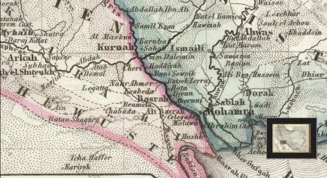
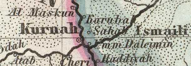
The below map (drawn in 1855, published in 1860) shows Qurnah as Kurnah and a village (?) called Umm Daleimin just to its east at the juncture of four rivers: (1) The Euphrates, (2) The Tigris, (3) The Kerkha, and (4) the Shatt al Arab which they form (Map titled: "Neueste Specialkarte von Persien." Map on page 106 of an atlas titled:
Grosser Hand-Atlas uber alle Theile der Erde in 170 Karten. Herausgegeben von J. Meyer. Hildburghausen Verlag des Bibliographischen Instituts. 1860. Please click here to access this map at the David Rumsey Historical Maps Archive)
Dr. Howard-Carter, PhD, if I am understanding her rightly, suggested in 1981 and 1987 that Sumerian Dilmun, 3200-2300 BC, might be a yet unexcavated mound or tell on the east side of either the Tigris and or the Shatt al-Arab, between Qurnah and Basra, overlooked by archaeologists. The above maps show Umm Daliemin (Dilmun?) as between Qurnah and Basra just as she predicted (interestingly, the very area Associate Professor Eric Cline suggests the Garden of Eden might be located at):
"However, because no objects from Mesopotamia found in either Bahrain or Failaka can be dated earlier than 2200 B.C., it is impossible that Dilmun was located there before that time. Thus, as I have attempted to demonstrate here, the earliest Dilmun is most likely to have been located in the region of Qurna."
(p. 223. Theresa Howard-Carter. "The Tangible Evidence for the Earliest Dilmun." Journal of Cuneiform Studies. Vol. 33. No. 3/4 (July-October 1981). pp. 210-223)
"The written record at this time points toward a Dilmun location near to, but east of Sumer. Suffice it to say that a number of archaeologically unidentified mounds are concealed by palm groves on the east banks of the Tigris and the Shatt al-Arab, according to local reports."
(p. 102. Theresa Howard-Carter. "Dilmun: At Sea or Not at Sea? A Review Article." Journal of Cuneiform Studies.
Vol. 39. No. 1. (Spring 1987). pp. 54-117)
Howard-Carter after enumerating clues from ancient texts describing Dilmun notes that the region of Qurna meets some of the textual criteria: (1) its being east of Sumer where the sun rises according to texts; (2) its location at "the mouths of the rivers" which she identifies with the mouths of the Tigris and Euphrates which form the Shatt al Arab at Qurna and its possessing (3) "a river bank" and (4) its marshland setting according to texts:
"With these characteristics describing Dilmun specified, we turn to the much discussed matter of the location of Dilmun in the Sumerian period. Dilmun is specifically defined in the texts as: The land of crossing; The land of Sun rising, in which dwell Ziusudra and the secret of immortality'; House on the river bank of the land; The ultimate house of Utnapishtim (the Akkadian equivalent of Ziusudra) at the mouth of the rivers; Enki...controls the two rivers, and the marsh waters which wash the reeds teeming with capricious fish; The holy buildings in Eridu, Nippur, and Dilmun belong to Enki and his father Enlil. It is clear from the Journey texts that these cities are closely linked by easy water transport through the marshes. Eridu, Nippur and Dilmun all border the great expanse of the marshlands...The criteria imposed upon us by the myths thus serve to narrow considerably the field of possible locations for early Dilmun...These positive descriptions suggest strongly a location in the region of Qurna, where date palms abound, trees flourish, and the fields are cultivated. The mouth of the two rivers should be interpreted as being their confluence, where even today the waters are wide and impressive. Qurna lies to the east of the Sumerian cities on the distant end of the marshes and consequently stretches into unknown territory. It is also on a river bank."
(pp. 219-220. Theresa Howard-Carter. "The Tangible Evidence for the Earliest Dilmun." Journal of Cuneiform Studies. Vol. 33. No. 3/4 (July-October 1981). pp. 210-223)
Howard-Carter on the location of the "mouths of the rivers" where Dilmun was sited in ancient texts being the area of Basra Qurnah in Iraq and the above map of 1860 shows Umm Daleimin (Dilmun?) as between Qurnah and Basra:
"The exact position of the confluence of the two major rivers has certainly varied during the last five to six thousand years. But in the period of Sumerian historical memory our geological documentation dictates a location in the Basra-Qurnah region."
(p. 220. Note 68. Theresa Howard-Carter. "The Tangible Evidence for the Earliest Dilmun." Journal of Cuneiform Studies. Vol. 33. No. 3/4 (July-October 1981). pp. 210-223)
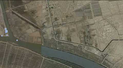
My Note (20 Feb. 2010): Howard-Carter's preceding 1987 observation that "local reports" of the possible existence of archaeologically uninvestigated mounds on the east bank of the Tigris/Shatt al Arab seems to be borne-out by satellite photos of this area, Qurna to Basra (accessible now, since 2005, on the internet via Google Earth). I note especially a large mound (?) on the east side of the Tigris and the NE bank of the Shatt al Arab due east of Qurna. A map from circa 1860 published in Germany shows a village in this very area called Umm Daleimin. Could Daleimin preserve Dilmun? Has this mound been archaeologically investigated? If it hasn't, it needs to be! Perhaps this mound (?) is Dilmun preserved in 1860 as Umm Daleimin?
Below, a satellite map showing Qurnah on the viewer's left (small white squares are clustered over it) and to the viewer's far right and due east of the Tigris what might (?) be the remains of an ancient tell, perhaps Dilmun?
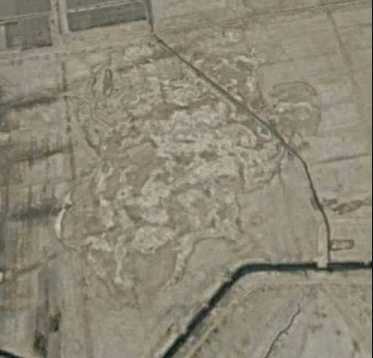
Below, a closeup of the possible (?) tell of Dilmun from the above satellite view. Its south side appears to have the remains of an ancient harbor (?) with two jetties (?). Of course, only after excavations have been done will we know if this is indeed an ancient tell. if it is Dilmun it ought to have pottery debris from circa 3200-560 BC when Dilmun appears in ancient texts. Note: Sometimes ancient site "loose" their names. When abandoned the site's name is sometimes given to the newer settlement and the ancient site acquires some other name. For example, ancient Jericho's ruins are called today Tell es Sultan, the ancient name survives in the nearby _modern_ village of Eriha. Thus the village (?) of Umm Daleimin "might" preserve the name of ancient Dilmun (if I am correct in proposing the physical anomaly picked up in the below satelitte photo is of Dilmun's ruin tell).
I am _unaware_ of anyone proposing that Dilmun "might" be Umm Daleimin. This proposal in uniquely my own.
I am also unaware of anyone besides myself noting that Esarhaddon's 30 beru being 220 kilometers (132 miles) disqualifies Bahrain being the Dilmun which lay some 30 beru away in the sea of the rising sun (I identify the sea of the rising sun with the Sea Lands conquered by Sargon II, lying between Sumer and Elam).
Howard-Carter (1987) states that an Assyrian district list seems to locate Dilmun in the vicinity of Eridu and Kisik, the latter usually associated with Tell el-Lahm, east of Eridu (Tell Abu Shahrain). She uses the terms "baffling" and "inexplicable" as most scholars place Dilmun at Bahrain which is not near Eridu or Kisik (Tell el-Lahm?) nor is it in the midst of marshes. Scholars are divided as to whether Tell el Lahm is Kisik or not, scroll down for a map showing the site of Tell el Lahm to be ancient Durum or Dur-Iakin rather than Kisik; also note that Kisik also is rendered Kisiga by some scholars as of 2008 (emphasis mine):
"Kessler also mentions a baffling Assyrian "district list" according to which Dilmun appears at that time to be located between Eridu and Kisik (Tell el-Lahm?) on the edge of, if not in, the marshes. A similar location is indicated by an inexplicable line on a tablet describing the Ritual for the Observance of Eclipses from Ashurbanipal's library at Nineveh: "I am a man from Telmun whose boat has sunk in the marshes."
(pp. 95-96. Theresa Howard-Carter. "Dilmun: At Sea or Not at Sea? A Review Article." Journal of Cuneiform Studies.
Vol. 39. No. 1. (Spring 1987). pp. 54-117. published by the American Society of Orientalists, ASOR.)
My note: Apparently the above "Kessler text" being cited by Howard-Carter is (?):
Karlheinz Kessler. 1980. Untersuchungen zur historischen Topographie Nordmesopotamiens nach keilschriftlichen Quellen des 1. Jahrtausens von Christ. Wiesbaden, Germany. TAVO Beihefte 26, Reihe B. [TAVO is the Tubinger Atlas Vordern Orient, in English: "The Tubinger Atlas of the Near East"].
Howard-Crawford seems to be of the opinon Dilmunites were active in the area east of the Tigris and the above satellite photo shows a ruin-mound (?) east of the Tigris at Qurna.
"About 2750 BC the sea level was up 2-3 meters, the marshes of southern Iraq expanded, and one might with justification presume that water travel was prevalent. The Dilmunites may have remained east of the Tigris at this time, but their ships surely ranged Gulf waters."
(p. 103. Theresa Howard-Carter. "Dilmun: At Sea or Not at Sea? A Review Article." Journal of Cuneiform Studies.
Vol. 39. No. 1. (Spring 1987). pp. 54-117)
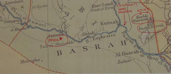
Below, a map (published in 1901 in London by Edward Stanford, Ltd. from an Atlas) showing a Kushk Hawizeh (a lagoon) and a Kushk Bozrah (a settlement) east of Kurnah (Qurnah). The village of Umm Daleimin appears on a 1855/1860 map east of Qurnah/Kurnah while Eridu (modern Tell Abu Shahrain) has been inked-in by myself as west of Suk es Sheiqukh. "If" Umm Daleimin is Dilmun and "if" Kushk is Kisik, then Dilmun lies _between_ Eridu and Kisik as stated in the Neo-Assyrian District List as noted above by Howard-Carter in 1987. Excavations will need to be done to see if there exists an ancient tell near Kushk that might be ancient Kisik of the Neo-Assyrian inscriptions.
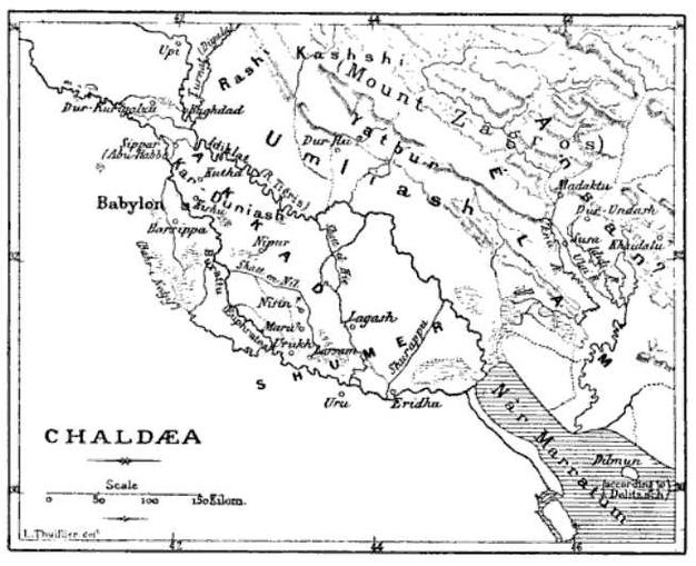
Please click here for Roux's 1960s maps. Professor Potts in the 1990s noted that sometimes the cuneiform word for "sea" can refer to an area of lagoons and marshes rather than an open sea like the Persian Gulf. Apparently, based on Rouxs' findings, Eridu and Ur's "sea" was not the Persian Gulf it was the marshland to their east called the Tamti or "Sea Land" or "Land of the Sea." Products of the Sea Land were cattle, timber, dates and vegetables. Why did Delitzsch place Dilmun near the present Shatt al-Arab's mouth? He understood apparently that 30 beru from Sumer was mouth of the Shatt al-Arab! (for the below map cf. p. 563. Vol. 1. Gaston Maspero. The Dawn of Civilization: Egypt and Chaldea. New York. D. Appleton & Company. 1894). Note: Eridu (Eridhu) is in the wrong location, it should be 12 miles SW of Ur (Uru on the map).
Below a map (1894) showing Dilmun as an island near what would be the mouth of the Shatt al-Arab on modern maps (1990s). Professor Friedrich Heinrich Delitzsch of Leipzig proposed in his book titled Wo lag das Paradeis? (Leipzig. 1881) this was where Dilmun should be (he drew Dilmun on a map accompanying his book). Delitzsch believed that behind the mythical Garden of Eden lay the Sumerian island of Dilmun. It was understood by 19th century scholars that the head of the Persian Gulf in antiquity had been near Ur and Eridu based on cuneiform texts mentioning a sea in their vicinity. It was assumed that with the passage of time the deltas of the Tigris and Euphrates pushed back the Persian Gulf to its present location. For Delitzsch this meant that Dilmun was by 1881 most probably covered over in delta silts. Georges Roux explored this area personally in the 1960s and established the presence of numerous settlements dated to the 2d millennium BC along the banks of a branch of the Euphrates river heading south from Ur to Basra. He found irrigation canals and wells. He concluded scholars since the 1860s were _wrong_ the Gulf had never been at Ur and Eridu, if it had, these villages wouldn't exist. Dilmun appears on the below map in the viewer's lower right corner, the Persian Gulf being labeled Nar Marratum "River Bitter." Note: Ur _in error_ is shown to be west of Eridu. Actually Eridu is 12 miles southwest of Ur. I understand that scholars are in error regarding the Nar Marratum , its not the Persian Gulf, its the Tigris and Euphrates rivers encircling Lower Mesopotamia. Click here for my arguments.
'If" Umm Daleimin is Dilmun and "if" 30 beru are Esarhaddons' 220 kilometers (132 miles), then Dilmun, in the sea of the rising sun, at the mouth of the rivers, is in the Sealand, the mat tamti, and 220 kilometers west of Umm Daleimin is es Samuawa on the Euphrates. That is to say the "beginning" of the "Sea of the Rising Sun" may have been envisioned as the swamps near Samuawa, to the south of Babylon and modern Hilla? The "problem"? The Sealand is usually differentiated from the land of Sumer, and Ur and Eridu are usually associated as being in Sumer, not in the Sealand.
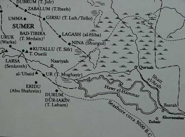
Below, a map showing Tel al Lahm (1964) to be ancient Durum or Dur-Iakin instead of Kisik as understood by Howard-Carter in 1987 or today's Kisiga as of 2008 (for the map, cf. Georges Roux. Ancient Iraq. London. Penguin Books. [1964] 1992).
Professor Parrot (1961) noted that Eridu and Tell el-Lahm appeared to be the farthest south settlements of Ancient Mesopotamia and that near them lie in antiquity the Persian Gulf. He noted that in 1952 Lees and Falcon proposed that scholars were wrong, the Persian Gulf had never been near Eridu, Ur and Tell el-Lahm, it had always been where it is today. Parrot noted cautiously if Lee and Falcon were right maybe, some day, other ancient settlements might be found bewteen Ur, Eridu and Tell el-Lahm and the Persian Gulf south of Basra:
"Two English geologists, G. M. Lees and N. R. Falcon, in 1952, put forward a revolutionary theory. Contradicting the usual opinion that in the earliest periods the head of the Persian Gulf began several hundred miles north of its present position, they maintained instead that it had varied relatively little in five thousand years. Their theory is a challenging one and will need to be carefully verified. Yet there is always the possibility that some day traces of human habitation will be discovered to the south of Abu Shahrein (Eridu) and Tell el-Lahm, hitherto regarded as the most southerly inhabitated sites."
(pp. 38-39. "The Garden of Eden From the Origins to Historical Times (5000-2800 BC)." Andre Parrot. The Arts of Mankind Series vol. 1: Sumer, The Dawn of Art. New York. Golden Press. 1961)
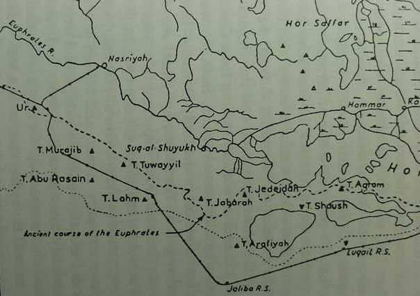
Below, map (1960) showing an ancient branch of Euphrates south of Qurnah, near which are several ancient settlements dated by Roux to the 2d millennium BC (ancient sites are black triangles, modern sites have inverted triangles). These sites seem to suggest for me that Lees and Falcon were right, the Persian Gulf was never at Eridu and Tell el-Lahm. I note two sites between Tell al Lahm and Eridu (Eridu is not on the map but it is just SW of Ur), Tells Murajib, Rasain, and Tuwayyil. "If" Tell al Lahm is Kisik, and "if" Dilmun lies between Eridu and Kisik, then either of these tells might be ancient Dilmun? (For the below map cf. p. 37 map titled "The Hor-Al-Hammar." figure 1.17 Archaeological sites in the Hor al-Hammar (after Roux 1960: Map 1). D.T. Potts. 1997. Mesopotamian Civilization: The Material Foundations. Ithaca, New York. Cornell University Press)