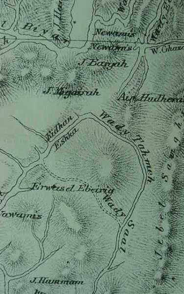
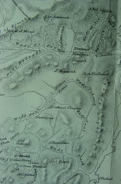
Map of Kibroth-hatta'avah and Taberah (Erweis el Ebeirig)
with a photo of the "Graves of craving."
(Numbers 11:34-35, 33:16-17; Deuteronomy 9:22)
17 August 2006 (Revisions through 28 Dec. 2022)
Nu 10:33; 11:3-4, 34; 12:16 (RSV)
"So they set out from the mount of the Lord three days journey...the name of that place was called Taberah, because the fire of the Lord burned among them. Now the rabble that was among them had a strong craving; and the people of Israel also wept again, and said, "O that we had meat to eat!"...Therefore the name of that place was called Kibroth-hatta'avah, because there they buried the people who had the craving. From Kibroth-hatta'avah the people journeyed to Hazeroth; and they remained at Hazeroth...After that the people set out from Hazeroth and encamped in the wilderness of Paran."
Edward Henry Palmer suggested (1869-1872) that Kibroth-hatta'avah might be Erweis el Ebeirig:
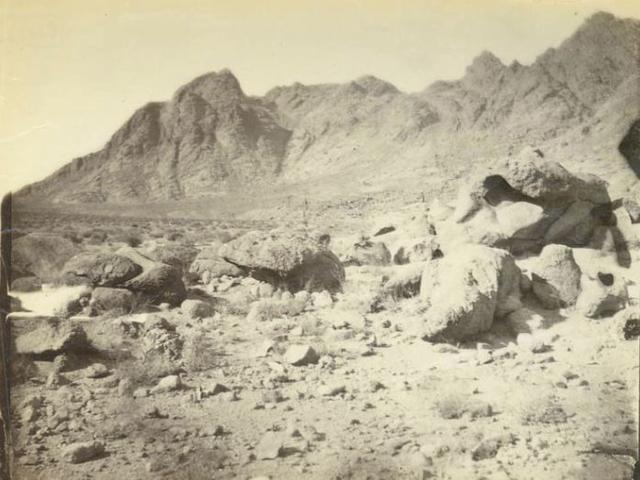
"A little farther on, upon the water-shed of Wady el Hebeibeh, we came to some remains which, although they had hitherto escaped even a passing notice from previous travelers, proved to be among the most interesting in the country. The piece of elevated ground which forms this water-shed is called by the Arabs Erweis el Ebeirig, and is covered with small enclosures of stones. These are evidently the remains of a large encampment, but they differ essentially in their arrangement from any others which I have seen in Sinai or elsewhere in Arabia; and on the summit of a small hill on the right is an erection of rough stones surmounted by a conspicuous white block of pyramidal shape. The remains extend for miles around, and, on examining them more carefully during a second visit to the Peninsula with Mr. Drake, we found our first impression fully confirmed, and collected abundant proofs that it was in reality a deserted camp. The small stones which formerly served, as they do in the present day, for hearths, in many places still showed signs of the action of fire, and on digging beneath the surface we found pieces of charcoal in great abundance. Here and there were larger inclosures marking the encampment of some person more important than the rest, and just outside the camp were a number of stone heaps, which from their shape and position, could be nothing else but graves. The site is a most commanding one, and admirably suited for the assembling of a large concourse of people...For various reasons I am inclined to believe...that we have in the scattered stones of Erweis el Ebeirig real traces of the Exodus...the distance -exactly a day's journey- from 'Ain Huderah, and those mysterious graves outside the camp, to my mind prove conclusively the identity of this spot with the scene of that awful plague by which the Lord punished the greed and discontent of His people...And he called the name of that place Kibroth-hattaavah, because there they buried the people that lusted. And the people journeyed from Kibroth-hattavah unto Hazeroth, and abode at Hazeroth (Numbers 11:33-35)."
(pp. 212-214. Edward Henry Palmer. The Desert of the Exodus: Journeys on Foot in the Wilderness of the Forty Years' Wanderings. New York. Harper & Brothers, Publishers. 1872)
Itzhaq Beit-Arieh excavated at Erweis el Eberig and dated the site to the Early Bronze Age II period (ca. 2900-2600 BC. (cf. Itzhaq Beit-Arieh. Archaeology of Sinai, The Ophir Expedition. Tell Aviv. Tel Aviv University. 2003. ISBN 965-266-018-3).
Because Eweis el Ebeirig did not date to circa 1446-1406 BC (1 Kings 6:1) and Moses' Exodus, it was eventually dropped from consideration as being an encampment of Israel.
My take on all this?
I understand Palmer was correct, this is Kibroth-Hattavah in spite of it being an Early Bronze Age site.
Why?
It is my understanding that the Exodus account was written in the Babylonian Exile, circa 562 BC. At that time no one knew the real age of any ancient site, in Egypt, the Sinai, Negeb, Arabah, Edom, Moab, or Canaan. Not having access to Sir Flinders Petrie's Pottery Typologies developed at the close the 19 th century AD, there was no way an Israelite of Iron Age II (8th/6th centuries BC) would know how old a site was.
It is my understanding, consequentially, THAT ALL the ANCIENT SITES appearing in the Exodus narratives WERE MISDATED 1446-1406 BC by the 562 BC Exilic author.
Archaeology confirms many Exodus sites are real, but excavations reveal they are from different time periods: Chalcolithic to Iron Age II.
As regards the Bible having quail in great quantity eaten, I note that the Arabic word for quail is salwa, while Hebrew is selaw. Furthermore, I note that Erweis el Eberig is situated on a Wadi Sa'al. Could Sa'al be a corrupted form of Hebrew selaw, hence why the Bible has the eating quail (selaw) that causes the deaths of Israel and the graves found by Palmer? It might also be that the Hebrew selaw is a deliberate play on words and Wadi Sa'al was recast in Hebrew as selaw?
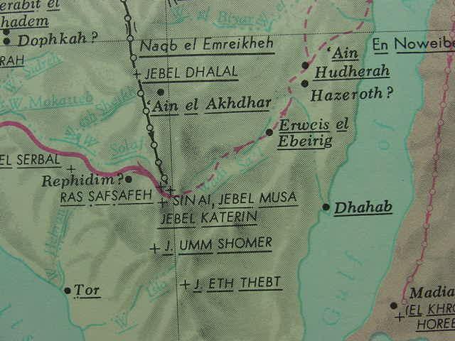
The ancient pottery debris found at Gebel Musa (the traditional Mt. Sinai) on the plain of Er-Raha (found in 1990) dates to the Neolithic Era of 5,000 BC.
For me, this Neolithic settlement on the Er-Raha plain below Ras Safsafeh ( my Mt. Sinai) was misdated in 562 BC by the Exilic author as being ca. 1446 BC (cf. 1 Kings 6:1) and so, too, were the 2900/2600 BC pottery remains at Erweis el Ebeirig.
IT IS MY PROPOSAL THAT the large quantities of ash and charcoal left by the ancient campfires of Ebeirig's encampment (cf. Palmer) were most likely accounted for in the Bible as being TABERAH, "the place of the burning."
The stone heap graves at the perimeter of the camp became, in the Bible, the "Graves of the Lusting," or Kibroth-Hattaavah (as so noted by Palmer in 1869).
That is to say, Palmer did NOT make any attempt to identify Taberah, per se, his focus was on claiming the site being Kibroth-Hattaa'avah because of its graves at the camp's perimeter.
The Reverend John M'Clintock noted (1891) that some scholars thought Taberah and Kibroth-Hattaa'avah were the same site and were to be identified with Erweis el Eberig:
"...From the omission of Taberah in the list at Numbers 33:16,17, and the absence of any statement of removal in Numbers 11, it has been by some inferred that Taberah and Kibroth-Hattaavah were but different names for the same place...Kibroth-hatta'avah...corresponding in position to the Erweis el Eberig, where Palmer has found traces of an ancient encampment (Desert of the Exodus, p. 212 sq)." (cf. p. 74. Kibroth-hatta'avah. Reverend John M'Clintock. and James Strong. Cyclopedia of Biblical, Theological, and Ecclesiastical Literature. New York. Harper and Brothers, Publishers. 1891)
Reverend Charles John Ellicott (1819-1905) of England proposed that Taberah and Kibroth-Hattaa'avah might be two terms for the same location:
"...Taberah may have been the name given to a part of Kibroth-hattaavah, or the two names may have belonged to the same place..." (Cf. Charles John Ellicott. Ellicott's Bible Commentary for English Readers.)
I suspect Ellicott's above proposal was spot-on correct: Taberah was, indeed, a part of Kibroth-Hattaa'avah, it being the campfire portion with its hearths containing charcoal and ashes, evidence of fires, whereas the stone heaps (Palmer's graves) at the perimeter were accounted for in the Bible as the "graves of the lusting." I wonder, has anyone ever examined to campfire ashes for the skeletal remains of quail?
The Early Bronze II stone circles at Sheikh Awad near Naqb el Hawah (Naqb el-Hauwa, "ascent of the wind") and Sheikh Nabi Salah have been excavated. If Mount Sinai is to be identified with Gebel Musa or Ras Safsafeh near Saint Catherine's Monastery, Israel would have most likely marched past either Awad or Salah to arrive and encamp on the plain of el Raha. To date (2006) no Late Bronze Age (ca. 1540-1200 BC) encampments have been found in the Sinai or Negev (Some scholars suggesting an Exodus ca.1446 BC or 1260 BC).
Hobbs has noted that a Neolithic (New Stoneage circa 5,500 to 4,500 BCE) settlement was found on a slight rise abutting the south western edge of the plain of er Raha (el Raha, ar-Raaha). Please click here for a map of the el Raha plain. On the map this "banana-shaped" rise is west of elevation number 4875, north of Ras Solaf and east of Jebel el Ghabsheh. I wonder if perhaps as early as Neolithic times some of the nearby mountains may have been regarded as "sacred" ? If Neolithic folk could dwell long enough here to build a settlement in stone, perhaps a tent-dwelling Israel could have survived here as well ? The banana-shaped rise would protect the settlement being destroyed by sudden flood torrents in the wadies descending Ras esh-Safsaf and Gebel Musa during the winter rains. The Bible has Israel encamped at Mt. Sinai/Horeb for one year, which would mean she would have to contend with possible winter flooding from the wadies emptying on to the er Raha plain. It would make sense to me that the banana-shaped rise would be the "safest" area for Israel to camp upon to avoid floods which could possibly destroy the encampment and the flocks of animals she had with her. When the 5th century AD Christian Pilgrimess Egeria (Etheria) visited this area she described the stone circles found in the area and stated that her guides, who were Christian Holy Men, informed her these were the remains of huts built by Israel when she camped beofre the Holy Mount for one year (cf. pp. 56-57. George E. Gingras [Translator and Annotator]. Egeria: Diary of a Pilgrimage. New York. The Newman Press. 1970)
Hobbs:
"I returned to Mount Sinai last week. I spent the first afternoon walking across the Plain of ar-Raaha, taking stock of the growth that has occurred there since my last visit in 1989...I spent the night in a two-year-old, one-hundred-bed hotel called Daniella Village. It reportedly sits directly atop a Neolithic period settlement on the banana-shaped rise at the southern end of the plain." (p. 306. "Conclusion." Joseph J. Hobbs. Mount Sinai. Austin, Texas. University of Texas Press. 1995. ISBN 0-292-73091-8)
An important Update of 17 December 2022 on Erweis el Ebeirig and E. H. Palmer (1870, 1879):
"Cala`at Nakhl, The Tih, January 19th, 1870:
"Since my last letter, dated from the Convent of Mount Sinai, I have reached the point from which my exploration of the interior region of the Tih commences...From Jebel Musa we proceeded to `Ain Hudherah, examining on our way the curious remains at Erweis el Ebeirig, the head of Wady Saal, which as I have said in a former notice of my visit last year, I believed to be the vestiges of an Israelitish camp. A second and more careful inspection of the spot has fully confirmed my previous opinion. The situation is a most commanding one, and the hill-sides and more elevated portions of the water-shed are covered for more than a mile in every direction with curiously arranged stones, evidently the remains of a large encampment; but differing essentially from any others that I have seen in the country, whether Arab or otherwise. The larger enclosures occupied by the more important personages, the hearths or fire-places etc., are still to be distinctly traced. At some distance are large heaps of stones, obviously burials without the camp; and a conspicuous stone erection on the hill to the right hand is surrounded by a regular series of smaller heaps, different, however, from the rest in their order and construction. The extent of the remains, indicating the assemblage of an unusually large concourse of people; the distance from Sinai on the one hand and `Ain Hudherah (the probable site of Hazeroth) on the other; and above all, the curious story of the lost Hajj caravan, all tend to confirm the supposition that we have here really a vestige of the Exodus."
Palmer's proposal was opposed by another scholar, the Reverend Frederick Whitmore Holland, M.A., F.R.G.S., Vicar of All Saints with St. Lawrence, Evesham, Worcestershire, England, from 1872 to his death on 27 August 1880 at Thun, Switzerland, who visited, in 1878 the above sites. This dissenter noted that the 600,000 men of the Exodus, plus their wives and children, were simply too large a host to have been able to navigate the twisting, narrow wadies leading to Erweis el Eberig and thence to Ain Huderah, and on to Kadesh-Barnea (emphasis mine in italics):
"...having explored on this or in previous journeys every wady leading from Jebel Musa, in the direction of the Gulf of Akaba, I felt convinced that all were unsuitable for the passage of the 600,000 men, besides women and children, of the Israelites. I had also explored the country to the north-west of Ain el Akhdar with similar results... I followed the course of W. Sa'al to Erweis el Ebeirig...I...am of the opinion that all these wadies are too narrow, rugged, and winding to have formed a road for the passage of the large host of the Israelites; nor can I at all agree with my friend Professor Palmer in finding in the numerous heaps of stones at Erweis el Ebeirig, the traces of the Israelitsh camp at Kibroth Hataavah, nor, again, do I hold it possible to identify Ain Huthera with Hazeroth..." (cf. p. 61. The Palestine Exploration Fund. Notes and News. April. 1879. Reverend F. W. Holland. "A Journey on foot through Arabia Petraea.")
Note:
Holland explored the Sinai on foot, on several occasions: 1861, 1865, 1866, 1868, 1878.
My take on Holland?
The biblical account of some 600,000 Israelite warriors traversing the Sinai for 40 years with their families in tow was at odds with Holland's findings.
Having personally trod on foot this wilderness, he tprobably realized that such a huge horde could not have traversed the narrow twisting wadies, so he rejected Palmer's proposal that Kibroth-Hatta'avah was Erweis el Ebeirig. But this rejection would have held for all of the other Sinai wadies.
Holland had apparently failed to realize he had found the proof that the Exodus was a fictional story, it was impossible that such a horde ever existed, but, probably for religious reasons, he kept quiet on all this.
Below, Palmer's Map (1872) showing the location of Erweis el Ebeirig, Wady Sa'al, and 'Ain Huderah (rendered a Ain Hudra on some 20th century maps), sites he associated with Kibroth-Hatta'avah and Hazeroth. He said it was a day's journey between the two sites via camels. As a day's journey is usually 8 hours, and a camel's pace is about two or two and a half miles an hour, the distance would be roughly 16-18 miles between the two sites.