Map of Mount Sinai or Mount Horeb (Gebel Musa, Gebel 'Arribeh & Ras Safsafeh)
15 Nov 2005 (Revisons through 29 May 2010)
Please click here for this website's most important article: Why the Bible Cannot be the Word of God.
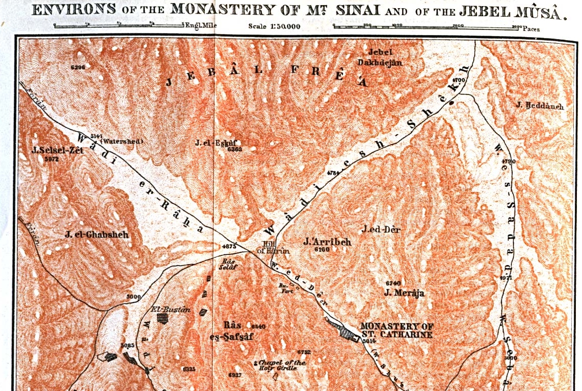
Egeria's Horeb might be Gebel `Arribeh, East-Northeast of the Saint Catherine Monastery. A hillock called the "Hill of Harun" at the base of Arribeh is identified as Aaron's Hill, perhaps envisioned as the site where the Golden Calf was displayed to Israel? The below Map of Mount Sinai and vicinity is circa 1912 and of a scale of 1:50,000. I note a peak called Gebel Sun'a which resembles some what the Greek rendering of Mt. Sinai as Sina in the 3rd century B.C. Greek translation of the Hebrew Bible called the Septuaginta, on the north side of the plain of er Raha, opposite Sheikh Harun, please click here for a map showing Gebel Sun'a.
The "problem"?
Horeb is pronounced in Hebrew as Choreb which, if correctly preserved in Arabic, _wouldn't_ be `Arribeh:
Strong 2722 Horeb, Choreb, Kho-rabe', "desolate;" from 2717 Charab khaw-rab' or Chareb, khaw-rabe', "to parch."
(James Strong. Strong's Exhaustive Concordance. Hebrew & Chaldee Dictionary. Waco, Texas. Word Books. 1977)
Archaeologists, despite repeated careful surveys of this area have found no evidence of a Late Bronze Age occupation in the form of encampments or burial tumuli which would be associated with the thousands who perished worshipping the Golden Calf. The Bible suggests for some Protestant scholars that the Exodus was ca. 1446-1406 B.C. (cf. 1 Kings 6:1). However, many Liberal scholars prefer an Exodus ca. 1250 B.C., which is also in the Late Bronze Age (The Late Bronze being ca. 1570-1200 B.C.). For these reasons (the lack of Late Bronze Age sites) most Liberal scholars regard the Exodus to be fiction as presented in the Hebrew Bible. A pilgrimess, called Etheria or Egeria, circa the 4th/5th century A.D., kept a diary of her visit to Mount Sinai, and she noted that it was approximately 35 Roman miles from the Mountain of God to Pharan/Paran, usually identified with the modern Feiran oasis, which agrees with Horeb/Sinai being the vicinity of Jebel Musa.
Gingras on when the Diary was composed:
"It seems clear that Egeria's Diary was written after 394; it is very probable that she could not have written it before 404; and there is reason to believe the work may not have been composed until 417. Suggestions of any later date are almost certainly to be rejected. The consensus of scholars is that the picture of church life which emerges from the narrative best describes the ecclesiastical and liturgical milieu of the early fifth century."
(p. 15. "Introduction." George E. Gingas [Translator]. Egeria: Diary of a Pilgrimage. New York, N.Y. & Mahwah, New Jersey. The Newman Press. 1970)
This pilgrimess also spoke of her approach to the mountain of God via a valley, which some scholars have suggested is Wadi er Raha. In this valley, her guides, who were the local "holy men", pointed out round or circular stone foundations of temporary huts, which they assured her were the remains of houses built by the Israelites as they dwelt before the mount of God. Archaeologists in recent times have excavated some of these structures and have determined them to have been built in Early Bronze Age II times by itinerant metal smiths from the Negev and the area of Arad who were exploiting the Southern Sinai's copper reserves. I have argued elsewhere that the Exodus account was written ca. 560 B.C. in the Exile by ONE author. I suspect that Iron II Israelites came to identify the temporary campsites of the Negev, Arabah and Sinai made from Chalcolithic to Middle Bronze I times as Israel's encampments. Cf. my Article on Exodus Memories of Southern Sinai, Linking the Archaeological Evidence to the Biblical Narratives. Cf. also my map of sites for the Route of the Exodus, Goshen to Jericho.
Archaeologists have noted the absence of Late Bronze Age evidence in the Negeb (The Exodus being portrayed as occuring in the Late Bronze Age by the Bible which gives two conflicting dates, 1540 B.C. or 1446 B.C., the 18th Egyptian Dynasty), but have "marveled" at the "intense" settlement of this area in the Middle Bronze I by nomadic invaders. These Middle Bronze I campsites also exist in the Northern Sinai, almost to the border of Egypt. I suspect that it is these campsites, Chalcolthic, Early Bronze and Middle Bronze I which came to be identified by Israel in the Iron II era as the encampments of Israel in the wilderness. I have argued elsewhere that the Primary History, Genesis-2 Kings was written ca. 560 B.C. in the Exile by one author. I suspect that it was in the Iron II era (1000- 587 B.C.) that these campsites were identified with Moses' Israelites. The Iron II Israelites naively assumed that the hundreds of campsites dotting the Sinai, Negev and Arabah from the Chalcolthic to Middle Bronze I were those of Moses' Israelites. They did not possess the "sophisticated" technologies (pottery typologies and synchronisms developed by Sir William Flinders Petrie and his successors) available to present day biblical archaeologists to distinguish Late Bronze Age from Middle Bronze I or Early Bronze II.
A European Pilgrimess called Egeria (4th/5th century A.D.?), left an account of her visit to Mount Sinai and from her remarks it appears that it is todays Jebel Musa near the monastery of Saint Catherine, she noting that Mt. Sinai is 35 Roman miles from Paran/Pharan (identified with the Feiran oasis) which is approximately the same distance. She portrays her guides telling her that Israel while encamped in the valley before Mount Sinai, had built houses for themselves, and that she was shown by her guides the remains of their walls, made of stones arranged in circles. Archaeologists have documented Egeria's words for they have excavated such circular stone houses and dated them to the Early Bronze II period. It is anybody's guess as to when these Early Bronze II seasonal encampments created by Asiatic miners from South Canaan and the Negev (Arad and vicinity) were transformed into "the many camps of Israel" wandering in the wilderness. Because these encampments litter the landscape of the Sinai perhaps the reason why Israel was portrayed as existing as 600,000 armed warriors in the biblical narratives? Probably ALL THE ENCAMPMENTS, Neolithic, Chalcolithic, Early Bronze and Middle Bronze, became in the retelling the "hundred-thousands" of Israel (the Iron Age II Israelites not being aware that these encampments "predated" their Late Bronze setting of Israel in the Sinai).
Egeria describes Kibroth-hatta'avah as being at the beginning of a great valley which opens onto a vast plain at the foot of the mountain of God. Her Kibroth-hatta'avah I suspect is the circular stone huts near Sheik Awad just north of Nagb Hawa, "the pass of the wind," this pass ends on the great plain of er-Raha.
Gingras on the valley traversed by Egeria leading to the plain of er-Raha:
"The approach to the valley is through the Nagb Hawa, the "Pass of the Wind"...It is from 200 to 300 yards wide, and on either side granite peaks and precipes tower to a height of 2000 feet above the path. Egeria describes the valley, the Wadi er Raha, or "Plain of Rest"...Egeria emphasizes the vastness of the valley."
(p. 161. footnotes 2 & 3. "Notes on Page 49." George E. Gingas [Translator]. Egeria: Diary of a Pilgrimage. New York, N.Y. & Mahwah, New Jersey. The Newman Press. 1970)
Egeria on the valley the Children of Israel settled in at the base of Mt. Sinai and their "circular stone houses" :
"We took a route by which we would go down the length of the center of the valley, which as I mentioned before, is the valley where the Children of Israel camped while Moses was ascending and descending the mountain of God. As we proceeded through the valley, the holy men continually pointed out to us each place. At the very head of the valley, where we had camped and had seen the bush out of whose fire God spoke to the holy man Moses, we saw the place where he stood before the bush as God said to him: "Loose the strap of your shoe, for the place on which you stand is holy ground." And as we set out from the bush, the guides began to show us all the other places. THEY POINTED OUT FIRST THE PLACE WHERE THE CAMP OF THE CHILDREN OF ISRAEL STOOD IN THE DAYS OF MOSES went up the mountain...THEN THEY SHOWED HOW EACH AND EVERY ONE OF THEM HAD DWELLINGS, THE FOUNDATIONS OF WHICH ARE STILL VISIBLE TODAY THROUGHOUT THE VALLEY, AND HOW THEY HAD BEEN BUILT IN A _CIRCULAR_SHAPE, OUT_OF_ STONE_. They showed us the place where the holy man Moses, on his return from the mountain, ordered the Children of Israel to run from door to door."
(p. 57. George E. Gingas [Translator]. Egeria: Diary of a Pilgrimage.New York, N.Y. & Mahwah, New Jersey. The Newman Press. 1970)
Egeria appears to understand that Mount Sinai (or mountain of God) and Mount Horeb were two mountains that were near each other. From her description I understand her mountain of God or Mount Sinai is today's Gebel Musa while Her Mount Horeb is Gebel Arribeh:
"Having satisfied every desire for which we had hastened to make the ascent, we now descended from the summit of the mountain of God, which we had reached, to another mountain which adjoins it. This place is called In Horeb, and there is a church there. Horeb is the place to which the holy prophet Elias came when he fled from before the face of Achab, and where God spoke to him...To this day they show the cave where the holy man Elias hid, in front of the door oof the church which is there, and also the stone altar which the holy man Elias himself set up to offer sacrifice to God. And the holy men therefore consented to show us each site."
(p. 54. George E. Gingras [Translator]. Egeria: Diary of a Pilgrimage. New York, N.Y. & Mahwah, New Jersey. The Newman Press. 1970)
Gingras on some scholars as early as 1774 identifying Horeb with Gebel Arribeh (Djebel Aribeh):
"qui locus appellatur in Choreb. The expression in Choreb is probably a transliteration from the LXX reading for Exodus 17.6 As W.F. Albright, From the Stone Age to Christianity (New York 1957) 262, shows, the early Israelites made little effort to establish the exact locations of Pentateuchal sites, and in Egeria's day the tradition reflected in the Onomasticon 173 seemed to place Horeb next to Sinai: Choreb, mons Dei...iuxta montem Sinai. Although Exodus 17.6 would indicate that Horeb was in the vicinity of Rapphidim (cf. note 16 above), the 'Horeb' in that verse is rearded by modern critics as a gloss. Legendre, op.cit. 1774, suggested that Egeria's Horeb is the Djebel Aribeh on the other side of Wadi ed Deir, and Anthony of Piacenza as well speaks of a valley between Horeb and Sinai (CCL 175.149: Inter Sina et Choreb est vallis...). However apparent from the Diary text (note the reference to the chapel of Elias; also note 47 below) that Egeria is referring not to the Djebel Aribeh but to another summit in the same range as the Djebel Musa."
(pp. 172-173. "Notes on Page 54." George E. Gingras [Translator]. Egeria: Diary of a Pilgrimage. New York, N.Y. & Mahwah, New Jersey. The Newman Press. 1970)
Greenwood on the plain of er-Raha (el Raha) and its ability to accomodate Israel's encampment:
"Early explorers and Old Testament scholars have attempted to measure the extent of Rahah to determine if it was large enough to hold the Host of Israel to which Moses delivered the Law. Estimates were that Rahah proper is 400 acres. Add to this the flat surfaces and lower slopes in Wadi Shreich, Seil Leja, and Wadi Deir, and some 1,200 acres would have been available for the encampment, but only 207 acres would have been needed for assemblage of the Host in the area of the Rahah itself (Barron p. 68).
Throughout this region are numerous permanent springs and small streams. The water supply here is among the most reliable of any area in Sinai."
(pp. 44-45. Ned Greenwood. The Sinai, A Physical Geography. Austin, Texas. University of Texas Press. 1997. ISBN 0-292-72799-2 paperback; citing T. Barron. 1907. The Topography and Geology of the Peninsula of Sinai [Western portion]. Cairo, Egypt. National Printing Department)
Greenwood (1997) on the location of trees associated with the production of Manna identifying several wadies in the southern Sinai (Note: Greenwood appears to be _unaware_ of the 1927 research of F. S. Bodenheimer which etablished that manna is a secretion of insects and _not_ a "gummy exudate of trees" as thought by Carl Ritter in 1866):
"Of the various plant foods of Sinai, none fired the imagination of European explorers like manna, the "bread of heaven." Speculation is rampant on what it really was or is...Theories fall along two main lines" "wind-blown" (lichens) and "honey-dew" (gum resins). Most theorists settle for the latter.
In Sinai, it is the honey-dew manna obtained from desert shrubs that receives most attention. Most tamarisks, some acacias, and even camel thorn produce exudates. The focus, however, is on the Tamarix mannifera (tarfa), also rendered T. gallica mannifera (French tamarisk). The exudate production of all other shrub species is probably less than that of the tarfa. Both volume and quality set it apart.
Carl Ritter, the noted German geographer, in his exhaustive 1866 study of the Sinai, devoted twenty-four pages plus numerous indirect references to touting tarfa as the biblical manna. While other scholars may not agree with Ritter, tarfa seems to be the logical candidate. Tarfa manna has for centuries been collected by Bedouin for their own diet and to sell to the pilgrims visiting the Judeo-Christian shrines of the peninsula. Distribution of Tamarix mannifera in Sinai is controlled by elevation and moisture; hence most occurrences are in wadi valleys below the 3,000-foot (914-meter) contour. Three fairly localized occurrences dominate Sinai: Wadi Sheikh, Wadi Feiran, and Wadi Gharandal. Wadi Sheikh is a tributary of Wadi Feiran. For part of its course, just above the juncture with Feiran, it is known as Wadi Tarfa. This concentration around Wadi Sheikh is convieniently close to Gebel Musa (widely accepted as Mount Sinai) and Er Rahah (Plain of the Promulgation of the Law). In addition to tarfa manna, many other gummy exudates have over the years yielded economic value to the Sinai."
(pp. 94-95. "Manna." Ned Greenwood. The Sinai, A Physical Geography. Austin, Texas. University of Texas Press. 1997. ISBN 0-292-72799-2 paperback)
Burckhardt (1816) on manna:
"I have already mentioned several times the Wady el Sheikh...in many parts it was thickly overgrown with the tamarisk or Tarfa; it is the only valley in the peninsula where this tree grows, at present, in any great quantity, though small bushes of it are here and there met with in other parts. It is from the Tarfa that the manna is obtained, and it is very strange that the fact should have remained unknown in Europe, till M. Seetzen mentioned it in a brief notice of his tour to Sinai, published in the Mines de l'Orient. This substance is called by the Bedouins, mann, and accurately resembles the description of manna given in the Scriptures. In the month of June it drops from the thorns of the tamarisk upon the fallen twigs,leaves, and thorns which always cover the ground beneath that tree in the natural state; the manna is collected before sunrise, when it is coagulated, but it dissolves as soon as the sun shines upon it. The Arabs clean away the leaves, dirt, etc. which adhere to it, boil it, strain it though a coarse piece of cloth, and put it into leathern skins; in this way they preserve it till the following year, and they use it as they do honey, to pour over their unleavened bread, or to dip their bread into. I could not learn that they ever make it into cakes or loaves. The manna is found only in years when copious rains have fallen; sometimes it is not produced at all, as will probably happen this year. I saw none of it among the Arabs, but obtained a small piece of last year's produce, in the convent; where having been kept in the cool shade and moderate temperature of that place, it had become quite solid, and formed a small cake; it became soft when kept sometime in the hand; if placed in the sun for five minutes it dissolved; but when restored to a cool place it became solid again in a quarter of an hour...Its colour is a dirty yellow, and the piece which I saw was still mixed with bits of tamarisk leaves: its taste is agreeable, somewhat aromatic, and as sweet as honey. If eaten in any considerable quantity it is said to be slightly purgative.
The quantity of manna collected at present, even in season when the most copious rains fall, is very trifling, perhaps not amounting to more than five or six hundred pounds. It is entirely consumed among the Bedouins, who consider it the greatest dainty which their country affords. The harvest is usually in June, and lasts for about six weeks; sometimes it begins in May. There are only particular parts of the Wady Sheikh that produce the tamarisk; but it is said to grow in Wady Naszeb, the fertile valley to the southeast of the convent, on the road to Sherm [the modern port of Sharm el Sheikh at the southern tip of the Sinai peninsula]." (pp. 453-454. Johann Ludwig Burkhardt [Anglicized: John Lewis Burkhardt]. Travels In Syria and the Holy Land. London. John Murray. 1822)
Please note on the below map Wadi esh Sheikh near St. Catherine's monastrey, a wadi famed for its manna production from tamarisk trees.