These maps accompany my article titled
Walter Reinhold Warttig Mattfeld y de la Torre, M.A. Ed.
24 February 2004
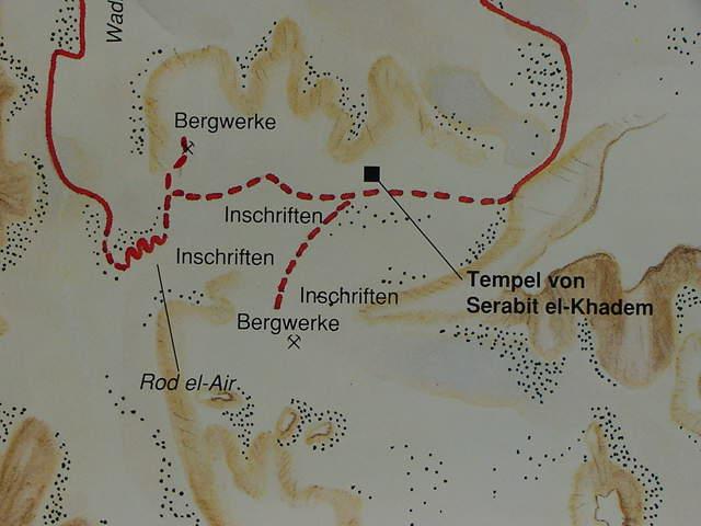
The below map shows the location of the Egyptian minining temple (German: "Tempel") dedicated to Hathor the patron-goddess of Egyptian miners. Note especially the location of the Proto-Sinaitic inscriptions ("inschriften" in German) near mines (German: "Bergwerk" on the map) and mining camps to the west and south of the temple. Djebel Serabit el-Khadim lies south of the temple and Djebel Ghorabi lies east of Djebel Serabit el-Khadim. I understand that the 12th Dynasty Proto-Sinaitic inscriptions, which have fallen from the face of the mountains near mining caves, and lying amongst scree and debris at the foot of the mounts, near Egyptian mining camps are what is behind the biblical notion of Moses shattering the two tables of stone or Ten Commandments and that Rephidim is preserved in Serabit el-Khadim, whilst the "rock -in- Horeb/Choreb" (Ex 17:6), is perhaps the "unidentified elevation" to the west of Djebel Ghorabi. I understand that Israel's Golden Calf worship recalls the singing and dancing in honor of Hathor at the Temple-shrine on the below map, who was a sky-cow-goddess who gave birth to the sun each morning as the Golden Calf. I identify Djebel Saniya with Mount Sinai, which does NOT appear on the below map, but which is adjacent to and south of Djebel Ghorabi and east of Djebel Serabit el-Khadim (cf. the below map of the Egyptian mining temple of Serabit el Khadim, on p.33. Alberto Siliotti. Sinai, Geschichte, Kunst, Touristik. 1994. Karl Muller Verlag. Erlangen, Deutschland). Was Israel envisioned as assembled in the area bounded by the Temple to the north, Djebel Serabit el Khadim to the west and Djebel Ghorabi to the east on the below map ?
Is it possible that Israel was envisioned as encamped in this plain, south of the temple, and west of Gebels Ghorabi and Saniya ? If so, then this would be "an ideal location" for Israel facing EASTWARDS Mount Horeb/Sinai (Ghorabi/Saniya ?) and the rising Sun. In the Bible Yahweh is metaphorically spoken of as "DAWNING" from Mounts Sinai, Paran and Seir. Israel on this plain south of the temple would at morning's dawn FACE Mount Sinai (Saniya ?) Paran (the mountains about the Feiran Oasis ?) and Seir (on the east side of the Arabah which extends south of the Dead Sea). Israel proclaims the Golden Calf led her out of Egypt to the Holy Mount, Aaron proclaims the morrow to be a feast day for the "lord" in Hebrew, YAHWEH. Evidently the Golden Calf's feast day IS YAHWEH'S FEAST DAY. A potsherd fopund in Iron Age Samaria inscribed egel-iah, "bullcalf-yah" suggests for me that Israel worshiped Yahweh as a Golden Calf. This also suggests that the Asiatic miners had no problem assimilating their gods to Egyptian gods, Hathor being called Baalat "Lady" on a Proto-Sinaitically inscribed Sphinx dedicated to her and found in the temple.