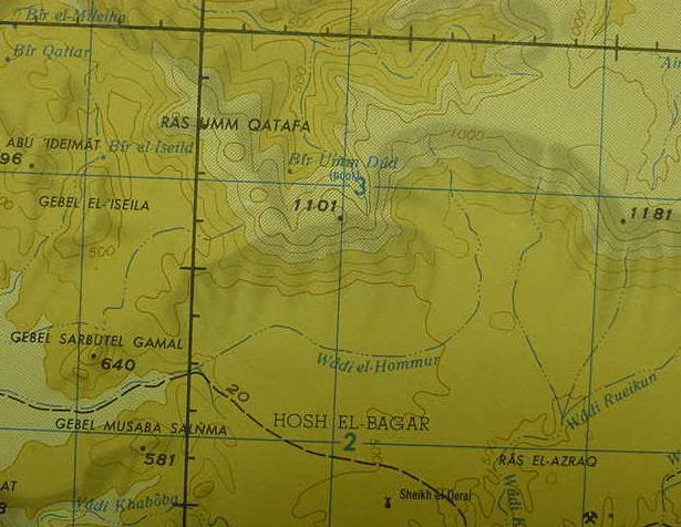
From the "wilderness of Sin, the Greek Septuaginta's Sina (either the high plain of El Sanawi north of Wadi Gharandal or the high plain of Hosan Abu Zenna, south of the wadi) Israel marched on to Dophkah and Alush. Perhaps Alush is Bir El-Guweisa (Al-Guweisa on other maps) on the below map (south of Hosan Abu Zenna), east of Gebel Thal and west of Ras Umm Qatafa (cf. the following below map) ? I envision Israel as following Wadi Tayiba eastward to the great plains of Hosh el Bagar and Ramlet Himeiyir (Qa`let El-Nakhl, Egypt. 1972. Sheet NH 36-11. Scale: 1:250,000. Washington DC).
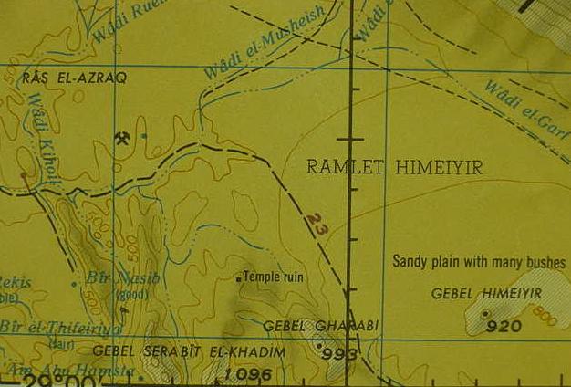
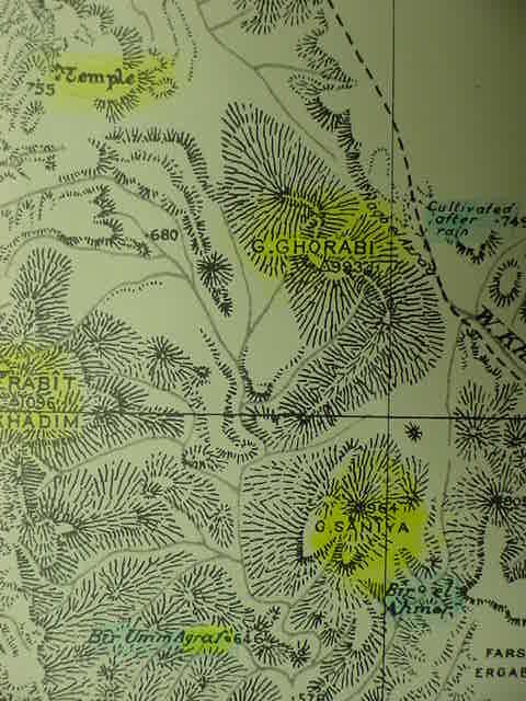
The site on the below map marked "Temple ruin" is the Egyptian shrine of Hathor, which existed from Middle Kingdom (12th Dynasty ca. 1991-1782 BCE) to New Kingdom times (ca. 1570-1293 BCE), including the Ramesside 19th (ca. 1293-1185 BCE) and 20th Dynasties (ca.1185-1133 BCE), Ramesses VI, (ca. 1141-1133 BCE) being the last Pharaoh to leave inscriptions there. Mining caves, encampments, burial tumuli and shattered tablet-resembling Proto-Sinaitic inscriptions are all to be found in the vicinity of Serabit el Khadim, notably the areas North, West, and South of the Temple ruin. I understand that Rephidim's name is preserved as Serabit el Khadim. The rock "in" Horeb/Choreb at Rephidim (Ex 17:6) I identify with Gebel Gharabi (Ghorabi on other maps) to the ESE of the "Temple ruin." Not appearing on this map is GebelSaniya , adjacent to and just ESE of Gebel Gharabi, which I identify with Mount Sinai.
The problem ? While the Shattered tables of stone bearing Proto-Sinaitic inscriptions of the 12th Dynasty (or possibly 18th Dynasty ?) -which I believe are what lies behind the Exodus account of Moses' shattering the Decalogue- are to the North, West and South of the Temple , I am NOT aware of ANY archaeological surveys being conducted in the "immediate areas" of Gebels Gharabi/Ghorabi and Saniya to establish what archaeological presence is, or is NOT attested.I can find NO mountains or locations to the North or West of the Temple Ruin, that "remotely look like" the biblical site names of Rephidim, Horeb/Choreb and Sinai. However, to the South of the temple are mining encampments and inscriptions. The Temple actually lies atop a high plateau, which is, itself, ringed by Gebels Serabit el Khadim, Gharabi/Ghorabi and Saniya, all of which are South of the Hathor temple ruin. Perhaps Israel was envisioned as assembled on this high plateau, south of the Hathor Temple ? I understand that the biblical notion that Israel honored the Golden Calf is recalling the dancing and singing held at the Hathor shrine honoring her as the cow-sky-goddess who gave birth each morning to the dawning sun as the Golden Calf. (Qa`let El-Nakhl, Egypt. 1972. Sheet NH 36-11. Scale: 1:250,000. Washington DC)
Ras Umm Qatafa (Dophkah ? Transposed qa ? d becoming t ?) is a prominent peak in the Et-Tih mountain ridge. I understand that Israel marched into the great plains of Hosh Bagar and Ramlet Himeiyir to Serabit el Khadim (Rephidim ?) via the track passing below the slopes of Ras Umm Qatafa.
On the below map, the Hathor Temple-shrine appears as "Temple." To the ESE lies Gebel Ghorabi, biblical Horeb/Choreb ? (Gebel Gharabi on the "above" map) and Gebal Saniya (Mount Sinai ?), both lie just east of Gebel Serabit el Khadim (Rephidim ?). Could the high plateau upon which the Hathor Temple sits, bounded by Gebels Serabit el Khadim, Ghorabi/Gharabi and Saniya be where Israel was envisioned as assembled ? Note the wadi which bisects this plain. Could this wadi have been envisioned as the "river" which nourished Israel for one year before Mount Horeb/Choreb/Sinai ? The Wadi's headwaters begin at Bir Umm Agraf. Could Wadi Agraf preserve "Rep-" of Rephidim ? Thus TWO nearby geological phenomenon are preserved in Rephidim, Wadi Agraf and Gebel Serabit el Khadim ? The Greek Septuaginta renders the Hebrew Sinai as Sina
(LXX: Ex 19:1-2) (cf. map titled Abu Zenima. Egypt. Southern Sinai. 1936. Sheet 5. Scale: 1:100,000. Survey of Egypt).
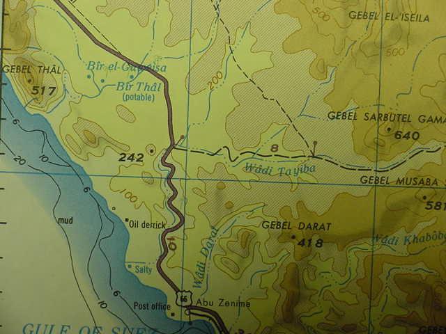
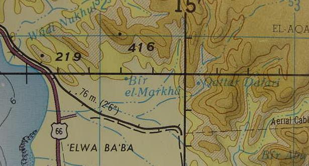
An alternate proposal:Dophkah might be the well of Qattar Dafari near Wadi Dafari, south of Ras Abu Zenima, and east of Bir el-Merkha, near the eastern edge of the plain of El Merkha, in the mountains; many scholars identify this plain with the Wilderness of Sin. Near Dafari, and east of Bir el Merkha Professor Gary D. Mumford, an Egyptologist, found a track from the plain which took ancient Egyptian miners to the interior and Serabit el Khadim ( Tor, Egypt. Sheet NH 36-15. Scale: 1:250,000. Washington, D.C. 1972)
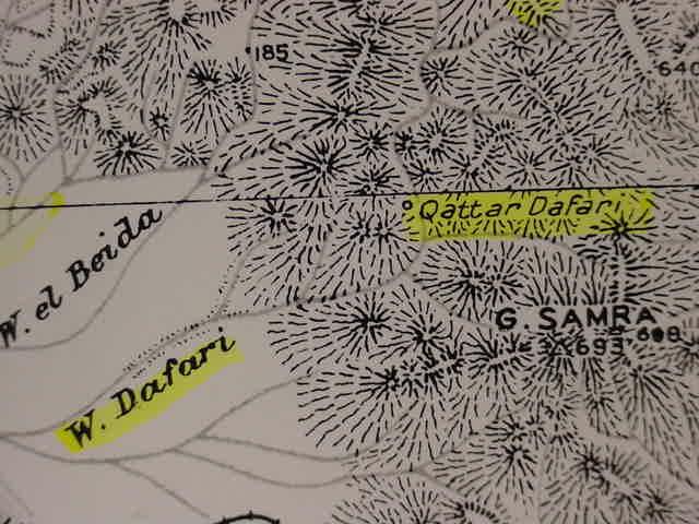
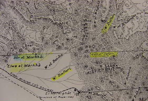
Below are two close-ups of Qattar Dafari, possibly Dophkah? (Abu Zenima. Southern Sinai. Sheet 5. 1:100,000. Survey of Egypt. 1936). The Egyptologist, Kenneth A. Kitchen understands with other scholars that the plain of el Merkha/Markha, south of Ras Abu Zenimeh, which wadi Dafari debouches on to, is the wilderness of Sin (cf. p. 269. Kenneth A. Kitchen. On the Reliability of the Bible. 2003. William B. Eerdmans. Grand Rapids, Michigan).