Map of Mount Sinai (Gebels Musa, Ras Safsafa, Katherina, Er-Rabbeii & Sun'a)
19 November 2004
(Revisions through 29 June 2010)
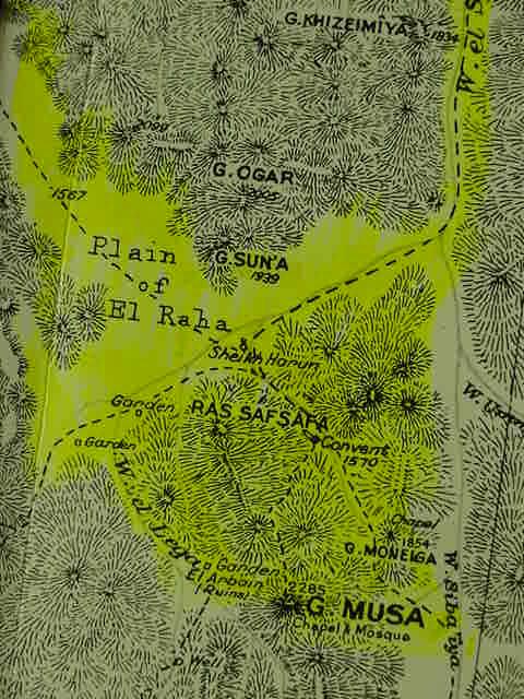
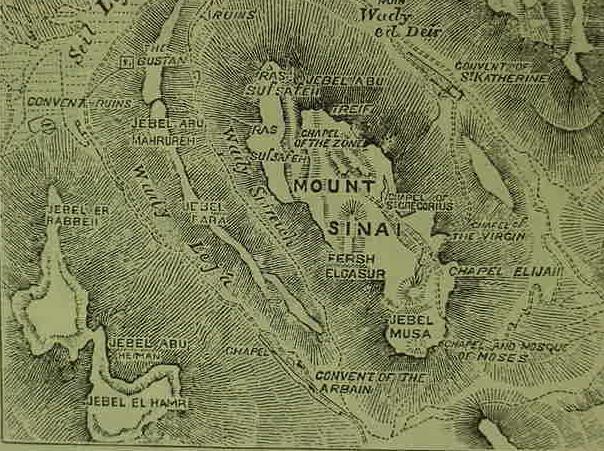
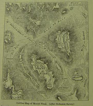
A number of peaks, elevations, and out-croppings vie with each other for the designation "Mount Sinai" or "Mount Horeb". For many, Gebel Musa (Arabic: "mount of Moses") is the location. Some suggest that the plain of el Raha (called er Raha on other maps) is where Israel assembled before the holy mount. The problem? Gebel Musa is not visible from the plain, its view is blocked by Ras Safsafa, accordingly, some have suggested that it is the latter peak that is the holy mount, not Gebel Musa. Still others, citing from the first century AD Jewish historian Flavius Josephus, who averred that Mount Sinai was the highest mountain understand that the Sinai's highest peak, Gebel Katherina, to the south of Gebel Musa is the sacred mount (named after a Christian lady called St. Catherine or Katherina). Still others noting that the mount is also called Horeb, have proposed that Gebel 'Arribeh to the east of Saint Catherine's Monastery is the holy mount. Gebel 'Arribeh does not appear on this map, to see 'Arribeh
Sheikh Harun on the below map is understood by Arabic traditions to be where Aaron presented the Golden Calf to Israel and adjacent to this site and just east of it is the peak of Gebel 'Arribeh equated by some with Mt. Horeb. Saint Catherine's Monastery appears on the below map as "Convent" (the below map is titled Gebel Katherina. Sheet 9. Southern Sinai. Survey of Egypt. 1937. 1:100,000 scale).
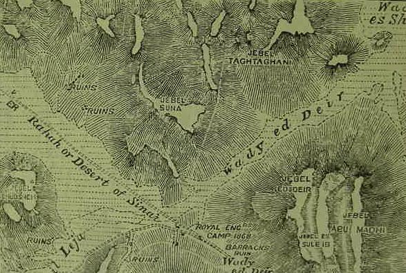
There is a peak called Gebel Sun'a on the north side of the plain of el Raha. Professor Har-El of Tel Aviv University has argued that suna in Arabic referred to "tradition or oral law," if he is right could Suna be Mount Sinai?
Har-El, arguing that Jebel Sinn Bishr near Ayun Musa is Mount Sinai:
"Here are our proofs for identifying this as the mountain of God:
a) The meaning of "suna" in Arabic is tradition or Oral Law among
the Moslems, and that of sanna is made law. The meaning of "bushr"
is to report good news, that of "bushra" is evangelical,
and "bashar" is man. Thus the meaning of Sin Bishr is the reporting
of the Laws, the Laws of man. This name hints at the Giving of the
Law. We should mention that this is the only mountain in the Sinai
peninsula, Midian and Edom where the name Sinai has been preserved
in the form "Sin."
(pp. 420-421. Menashe Har-El. The Sinai Journeys,The Route of the Exodus. Sa Diego, California. Ridgefield Publishing Company. 1983)
Christians by the 4th-6th centuries AD were making pilgrimages to the below locations and in the 6th century the fortified Monastery of St. Catherine was erected by the Emperor Justinian.
The problem?
To date (2004) archaeologists despite repeated careful archaeological surveys of this area have failed to find any evidence of Israel's presence via pottery debris. According to the biblical narratives Israel dwelt for _one year_ at Mount Sinai. No graves have been found of the thousands slain in the Golden Calf incident.
A number of Conservative scholars understand the Exodus was ca. 1446 BC based on 1 Kings 6:1. Others, understand that as the Exodus departed a city called Rameses the Exodus must be in the reign of Ramesses II who built a city called Pi-Ramesses in the eastern Delta. Both Exodus dates, 1446 or 1260 BC, fall within the archaeological period designated as the Late Bronze Age, which is dated ca. 1560-1200 BC. Consequently, a number of scholars refuse to acknowledge any proposal as "correct" for the siting of Mount Sinai until it can be verified by pottery debris of this era.
The only pottery debris that I am aware of, being found in this area is of the Late Roman and Byzantine eras, the 4th-9th centuries AD. There is nothing to be found in this location of the period Before Christ (BC).
A 4th/5th century AD Christian Pilgrimess called either Egeria or Etheria or Silvia (from either France or Spain?) kept a diary of her visit to Mt. Sinai, and noted that it was approached via a long valley and that the monks who served as her guides pointed out to her the remains of stone circles in the valley which they said were huts built by Israel while she dwelt for one year at the holy mount.
Archaeologists have verified somewhat her diary and have excavated some of the stone circles. They are the remains of huts for nomads and corrals for their sheep and goats. They are not of the Late Bronze Age, 1560-1200 BC, however, they are of the Early Bronze II period, ca. 3000-2700 BC. These remains of the "Before Christ Era", however are not in the immediate vicinity of the locations appearing on the below map. These sites are some 4 miles ENE and WNW of the plain of el Raha. The Pilgrimess did say she encountered these stone circlas near the entrance to the long valley, and that she could see the sacred mount at the far end of the valley in the distance.
As is clear on the below map there are two routes into the plain of el Raha, from one the WNW and one from the ENE, each entry is via a long valley or wadi, and at the end or entrance to each of these "valleys" lies stone circle huts and corrals of Early Bronze II settlements (which have been excavated). Apparently the Christian Monks were mistaken in dating these structures to the time of Israel.
No one knew the age of the various structures which appear in the Sinai, Negev, and Arabah (places Israel wandered in according to the Bible) until Sir Flinders Petrie at the trun of the 20th century created a pottery chronology using associated Egyptian cartouches. Perhaps all the structures, New Stone Age through the Iron Age, found in the Sinai by the early Christians came to be misidentified with Israel's 40 years of wanderings?
The only Late Bronze Age pottery debris documented for the southern Sinai where early Christian tradition has the sacred mount situated is near Serabit el Khadim and its Egyptian-run mining camps which were in existence from Early Bronze Age times down to the Ramesside era which ended in this region ca. 1133 BC with Pharaoh Ramesses VI whose name cartouche is the last to appear at the Egyptian shrine dedicated to the miner's cow-sky-goddess Hathor, who, according to myth, gave birth as the sky each day to the sun as a Golden Calf.
Hobbs (1995) has noted that a Neolithic (New Stoneage) settlement was found on a slight rise abutting the south western edge of the plain of er Raha (el Raha, ar-Raaha). I wonder if perhaps as early as Neolithic times some of the nearby mountains may have been regarded as "sacred"? If Neolithic folk could dwell long enough here to build a settlement in stone, perhaps a tent-dwelling Israel could have survived here as well? The "rise" on the above map is just west of the word _El_ in "Plain of El Raha."
Please click here for a better map (more highly detailed) showing this "banana-shaped" rise.
Hobbs:
"I returned to Mount Sinai last week. I spent the first afternoon walking across the Plain of ar-Raaha, taking stock of the growth that has occurred there since my last visit in 1989...I spent the night in a two-year-old, one-hundred-bed hotel called Daniella Village. It reportedly sits directly atop a Neolithic period settlement on the banana-shaped rise at the southern end of the plain."
(p. 306. "Conclusion." Joseph J. Hobbs. Mount Sinai. Austin, Texas. University of Texas Press. 1995)
Too bad the pottery in the plain of er Raha (el Raha) is Neolithic (New Stone Age), if it had been Late Bronze Age (1560-1200 BC) or Iron Age I (1200-1100 BC) we might have had Israel's campsite at Mount Sinai, the Exodus being dated ca. 1512 BC by Roman Catholic scholars or 1445 BC by Protestant scholars, or 1312 BC by some Jewish scholars (cf. Seder 'Olam Rabbah) or 1260 BC by some Liberal scholars.
Is it possible that Israelites in the 9th-8th century BC (their pottery found at the Feiran Oasis by archaeologists) mistakenly identified the remains of the Neolithic settlement at er Raha as being that of an Israelite encampent of the Exodus?
Until Sir Flinders Petrie established pottery chronologies aligning them with Egyptian cartouches of the Pharaohs no one knew the age of any campsite in the Sinai, Negev or Arabah.
The Christian Pilgrimess Egeria (Etheria) who visited Gebel Musa in the 5th or 6th century AD stated in her diary that the Christian monks had told her that the stone circles found in the vicinity of Gebel Musa were "huts" constructed by Israel while she stayed for one year at Mount Sinai. Archaeologists have found these "huts" and established that they are of a much earlier period, the Chalcolithic (ca. 4500-3300 BC) and Early Bronze Age II (ca. 3000-2700 BC), not the Late Bronze Age and the 2nd millennium BC. Those of the Early Bronze II period had pottery made from clays found in the Arad area of the Negev. Copper residue in or near the "huts" established they were mining copper ore from nearby Wady Reqeita (east of Gebel Musa). Of interest is that Israel after a time in the Sinai, winds up near Arad where she is attacked by the king of Arad while mourning Aaron's death at Mount Hor (Nu 21:1, 33:40)
An excellent series of maps of Egypt, 1797-1798 by Napoleon's cartographers is now (2009) available on the internet at the David Rumsey Historical Maps Archive.
To access these maps click on the below active url links.
When the map appears on your screen move your cursor across its surface, this will cause a zoom bar to appear.
Click on the + (plus sign) to activate the map's zooming bar's features; repeated clicking on the + (plus sign) magnifies the map, repeated clicking on the - (minus sign) decreases the magnifying effect.
By placing your cursor on the map while holding down your mouse key a "hand" will appear allowing you to move the Map about to various sectors, right, left, up and down.
Please Click Here for the 1797-1797 panoramic overview of Egypt, the Sinai, and Palestine.
Please click here for "another" version (more details) of Egypt, including Suez harbor.