Please click here for my latest map (21 Nov. 2009) showing the site of Israel's "crossing of the Red Sea"
in the Exodus as being at Ras el Ballah (my Baal-zephon)
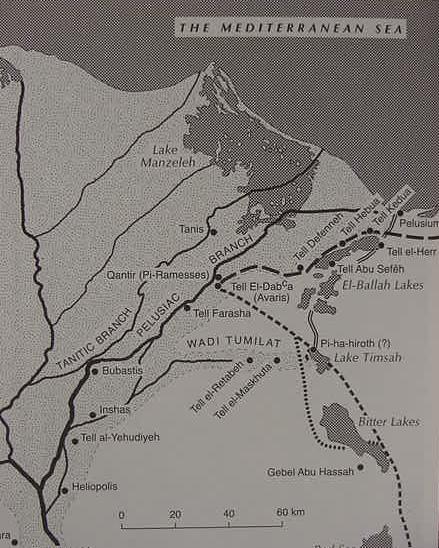
Map of Eastern Delta showing Zoan (Greek: Tanis), Ramesses (Qantir), Avaris (Tell ed Daba), Tell er Retabeh, Tell el Maskhutah. Ancient canal traces are noted as Hoffmeier and Kitchen argue Pi-ha-hiroth means "mouth of the canal." A small Egyptian shrine was found at Gebel el Hassa, the inscriptions being usurped by Ramesses II.Some argue this location is Baal Zephon as the Egyptian god Set appears on a relief and he was equated by the Egyptians with the Syrian war god Baal. The dotted lines mark the Exodus route. Succoth is understood to be a region within Wadi Tumilat. Etham being the east end of the Wadi or near Lake Timsah (cf. the map in James K. Hoffmeier. Israel In Egypt, The Evidence for the Authenticity of the Exodus Tradition. 1996. Oxford University Press. New York).