Tamar and the Waters of Meribath-Kadesh as Arabic Toponymns (Ezekiel 47:18-19)?
18 May 2010 (Revisions through 15 June 2010)
I am aware of only three Arabic toponyms remotely resembling the word Meribah (alternately Meribath or Meriboth).
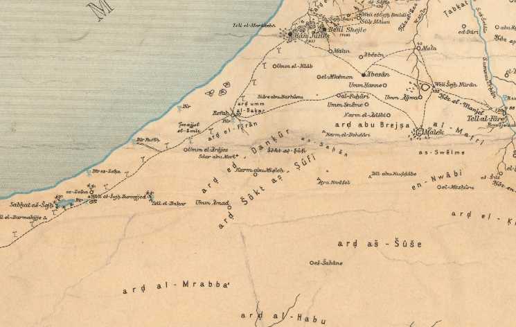
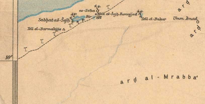
(1) In the wilderness S of Gaza and Khan Yunis at Ard al Mrabba' (Alois Musil. Karte von Arabia Petraea.
Map Scale of 1:300,000. Vienna. ca. 1907):
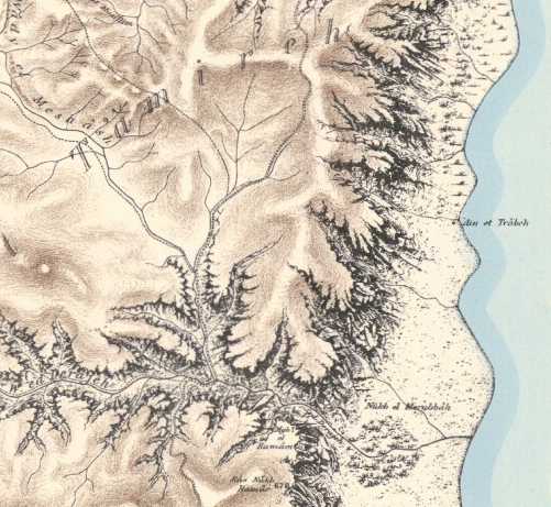
(2) In the wilderness of Judah near the west shore of the Dead Sea at Nukb el Merubbah north of Ain Jedi/Ain Gedi
(Palestine Exploration Fund Map. 1:63,000. London. 1878. Sheet No. 22):
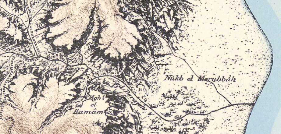
Of the above 2 examples I would tend to favor Nukb el Merubbah as the "waters of Meribah-Kadesh" as:
(1) Two wadies debouch on its plain, perhaps recalling the site's "waters"?
(2) It is near the Dead Sea which forms part of Judah's south border in the Bible.
(3) Ezekiel envisions Israel's Post-Exilic border as extending to Tamar and the waters of Meribath-Kadesh and a region called Arab et Tamireh is near Nukb el Merubbah, perhaps it is Ezekiel's Tamar?
Ezekiel 47:18-19 RSV
On the south side, it shall run from Tamar as far as the waters of Meribath-kadesh, thence along the Brook of Egypt to the Great Sea. This shall be the south side.
I note a region called Arab et Tamireh bordered on its SE side by two wadies terminating at Nukb el Merubbah, could this be Ezekiel's "Tamar as far as the waters of Meribath-kadesh"?
(3) N. [Nahr] el Murabba, a wadi draining from the E side of the Arabah to the NW of Busejra (Buseira/Bozrah) on Alois Musil's Karte von Arabia Petraea (1907). This wadi drains into other wadies that drain N into the Dead Sea.
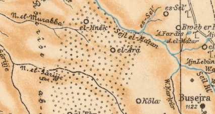
As Kadesh-barnea is "in" Edom's border and it is called Meribah-kadesh Nahr el Murabba might qualify as "the waters of Meribah-kadesh" as it is in the Edomite border on the E side of the Arabah. Some biblical verses suggest Israel laid claim to the Arabah valley. This area is forested (tiny circles are orchards) and could support a population for a considerable period of time. Would el 'Ara be Mount Hor (Hor ha Har)? The Septuaginta has the border descending from the ascent of Acrabin (Umm el Akareb on the southside of the Lisan peninsula?) to Ennac (Nu 34:4) instead of Zin/Zina/Sena. Would Ennac be el-Hnek?
Numbers 34:2-5 Septuaginta (Brenton 1851)
"And your southern side shall be from the wilderness of Sin to the border of Edom, and your border southward shall extend on the side of the salt sea eastward. And your border shall go round you from the south to the ascent of Acrabin and shall proceed by Ennac, and the going forth of it shall be southward to Cades Barne, and it shall go forth to the village of Arad, and shall proceed by Asemona. And the border shall compass from Asemona to the river of Egypt, and the sea shall be the termination."
The "problem" is that the border should be on the west side of the Arabah not the east side where lies Edom, unless the Arabah is being claimed as belonging to Israel, in which case the western foothills of Edom east of the Arabah "might" be envisioned as Israel's eastern border? Most definitely the Arabah N of the Dead Sea is reckoned as being Israelite. But is the Arabah S of the Dead Sea also reckoned as Israelite? Solomon builds the seaports of Ezion-geber and Elath in the land of Edom on the Red Sea which might suggest Israel laid claim to the Arabah S of the Dead Sea.
Exodus 23:31 RSV
"And I will set your bounds from the Red Sea to the sea of the Philistines..."
Joshua 12:7 RSV
"And these are the kings of the land whom Joshua and the people of Israel defeated on the west side of the Jordan from Baal-gad in the valley of Lebanon to Mount Halak that rises toward Seir...in the hill country, in the lowland, in the Arabah, in the slopes, in the wilderness, and in the Negeb..."
In the Exodus Israel travels S from Arad to the Red Sea via the Arabah compassing Mt. Seir and is not allowed to conquer Seir as it is set aside by God for Esau's descendants. Seir is crossed near Aqabah at the Iytm pass. So, perhaps the Arabah was claimed by Israel all the way to Ezion-geber/Aqaba, Edom's western border being the foothills on the eastside of the Arabah. Thus some sites in Israel's south border "might" be along the periphery of the Edomite foothills E of the Arabah?
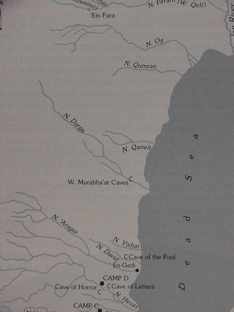
Apparently Wadi Murabba'at south of Qumran and north of Ain Gedi (see the below 1993 map) is in the same general area as Nukb el Merubbah. Wady ed-Derajeh which discharges on to Nukb el Merubbah appears in modern Israeli as Nahal Darga. So the PEF map's Wady ed-Derajeh is also known as Wadi Murabba'at. Where the below map has Nahal Darga the PEF map has Wady Meshash as the headwater.
At Wadi Murabba'at caves were identified possessing fragments of Genesis, Deuteronomy, and other books of the Bible. An Iron Age II presence was documented via pottery from of the 8th and 7th centuries BC. Ezekiel writing in the 6th century BC Exile could have heard tell of a "waters of Meribath-kadesh whose waters run to a great sea," and, in error, assumed the "great sea" was the Mediterranean when it was in fact the Dead Sea (greater in that it is much larger than the Sea of Galilee)?
Wikipedia:
"Wadi Murabba'at is a ravine cut by a seasonal stream which runs from the Judaean Desert east of Bethlehem past the Herodium down to the Dead Sea."
Ezekiel 47:18-19 RSV
"On the east side, the boundary shall run from Hazar-enon between Hauran and Damascus, along the Jordan between Gilead and the land of Israel; to the eastern sea as as far as Tamar. This shall be the east side. On the south side, it shall run from Tamar as far as the waters of Meribath-kadesh, thence along the Brook of Egypt to the Great Sea. This shall be the south side. On the west side, the Great Sea shall be the boundary to a point opposite the entrance of amath. This shall be the west side."
Below, map showing Wadi Murabba'at and its caves (p. 820. Vol. 3. Ephraim Stern, Editor. The New Encyclopedia of Archaeologocal Excavations in the Holy Lands. New York. Simon & Schuster. 1993)
Some scholars have suggested Massah and Meribah may be alternate names for the same location. If this be so then perhaps Massah is preserved in Wady el Meshash (PEF sheet No. 22) and Meribah in Nukb el Merubbah at its mouth?
Deuteronomy 33:8 RSV
"...whom thou didst test at Massah, with whom thou didst strive at the waters of Meribah..."
Conclusions:
As can be seen from the above examples Arabic is quite capable of preserving Meribah-Kadesh or Meribath-Kadesh as either Murabba or Murabba'at. Of interest here is that some verses render Meribah-Kadesh (De32:51) while others render Meribath-Kadesh (Ez 47:18-19) and I note a similar situation seems to exist for Nukb el Merubbah and Wadi Murabba'at, does Merubbah and Murabba'at preserve the Bible's two renderings of Meribah and Meribath?
Tamar is associated with Meribath-Kadesh and I note that Hazazon-Tamar is associated with En Gedi, which Josephus praised for its palm trees, tamar means palm tree.
2 Chronicles 20:2 RSV
"...they are in Hazazon-tamar (that is, En-gedi)."
Wadi Husasah (PEF Map, sheet 22, 1878 perhaps biblical Hazazon?) is south of Merubbah/Murabba'at and all three sites are north of Engedi (Hazazon-tamar).
For Tamar we have the region of Arab et Tamireh west of Nukb ("ascent of") el Merubbah and another Tamar at En-Gedi (biblical Hazazon-tamar).
This clustering of biblical site names near the Dead Sea and Judah's southeastern border suggests for me Ezekiel's Tamar and Meribath-Kadesh are near En Gedi, Tamar is _not_ south of the Dead Sea as is understood by some scholars based on the Byzantine Madeba mosaic map. Perhaps the Byzantine Christians did not know the location of Tamar?
The problems?
The present localities where this toponym is preserved don't align with the biblical narratives and other site names appearing in the stories. They appear _to me_ to be a jumble of locations as preserved in Arabic toponyms scattered about the areas of Philista, the Negev, the Hill Country of Hebron, the Judaean Wilderness, and Edom.
Either the locality, Meribah-Kadesh or Meribath-Kadesh, is no longer at its correct location (Ain el Kadeis? or Ain el Qudeirat?) preserved in an Arabic toponymn or the biblical narrator did not know in every case the proper juxtaposition of one site to another and just created a story using site names associated with the south country (Negeb).
I "suspect" the latter after some 30 years of personal research studying toponyms preserved in Arabic of biblical sites.
That is not to say Exilic narrator was always wrong. He was often correct, but "sometimes he apparently was wrong."
If Ain el Kadeis (Qadeis) is Kadesh then the waters of Merbath-Kadesh or Meribah-Kadesh should be in this area as an Arabic toponym, but such doesn't exist here; nor is there a wilderness of Zin nor a wilderness of Paran near Ain Qadeis or Ain Qudeirat (an alternate site for Kadesh-Barnea) as Arabic toponyms. Yet such toponymns somewhat similar to Zin and Paran do exist in other areas of southern Palestine.
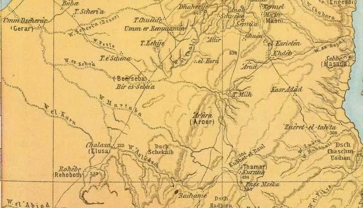
One last possibility for the "waters of Meribath-Kadesh" might be Wadi Martaba (Martabeh) SW of Beersheba. "If" the t ending has been transposed (mrtb= mrbt?)?
In this scenario the "waters" might allude to various wadies that eventually join Wady Martaba which in turn drains into Wadi Beersheba and reaches the Great Sea (the Mediterranean Sea just south of Gaza). That is to say the great Beersheba drainage basin might be the "waters of Meribath-Kadesh"? (cf. the below 1881 Map made in Germany showing Martaba draining to Wadi es Seba and the Mediterranean Sea)