For Christians visiting this website my most important article is: The Reception of God's Holy Spirit: How the Hebrew Prophets _contradict_ Christianity's Teachings. Please click here.
Please click here for this website's most important article: Why the Bible Cannot be the Word of God.
Please click here for the "original" version of this article prior to 04 Jan 2006
Please click here for Zin (Greek Septuaginta and Latin Vulgate Bibles' Senna) possibly being Khashm Zanna between Beersheba and Arad and Kadesh-barnea being Tel Masos (Its excavator noted it was the largest and earliest Israelite Iron Age I site in the Negeb, circa 1200-1100 BC and thought it might be Hormah, another, that it is an Amalekite City).
Revisions through 30 May 2014
The below is all admittedly "highly speculative." I have "struggled" for some 30+ years in attempts at locating the "Ascent of Akrabbim" and the rest of the sites appearing in the southern border of Judah/Israel. What follows will no doubt be somewhat controversial.
I have two conflicting proposals for Kadesh-Barnea and the Wildernesses of Zin and Paran it is associated with.
Proposal One: Zin is Khasm Zanna, Kadesh Barnea is Tell Masos, Akrabbim's ascent is Rugm Kharrubeh.
Proposal Two (This article): Zin is Gebel Sneb (Musil's map), Akrabbim is Naqb el Gharib.
Today, 30 May 2014, I favor proposal One.
The methodology I had employed for locating the sites in Judah's (and Israel's) south border were founded on a notion that the Ascent of Akrabbim "must still exist" in some Arabic toponym. I was aware that many scholars identified this location with Nagb es-Safr (variously also rendered Naqb es-Safr, Safa and Sfai) but failing to find "Akrabbim" or a similar looking word preserved in these toponyms I rejected this site. That was a _major error_ on my part, sending me off on a "wild-goose chase" which would last for many years!
I had noted a Rugm el Kharrubeh on the 1878 Palestine Exploration Fund Map on a steep ascent just west of Arad and thought this might preserve the name Akrabbim; to its west was a village bearing the name Kharubbeh. I must admit, however, at the back of mind, it "made sense" to me that in describing a border extending west from the Dead Sea's furthest south bay, that the ridge of mountains bordering the great Arabah rift valley was "a natural" for the location of the ascent of Akrabbim and thus I understood why many scholars associated it with Nagb es-Sfar (Safa/Sfai).
I finally in past the few days have "accepted" that the Israeli scholars are correct, the ascent of Akrabbim is to be associated with Nagb es-Sfar, "the ascent of Sfar" (Safar/Safa/Sfai). Their placement of the "wilderness of Zin as extending from the eastern perimeter of this chain of mountains also _makes sense_. The modern Israeli maps of Israel (1979) show the Wilderness of Zin extending from just south of modern Sede Boqer to Nagb es-Sfar- I am now in "agreement" with this.
The Israeli produced Map of Israel (1979) shows a Har Zin "mount Zin" as lying in the basin formed by Wadi Marra/Murra, now renamed Nahal Zin. Here I disagree. Many scholars also favor Kadesh-barnea to be either Ain el Qadeis or Ain el Qudeirat, again I disagree.
For my new proposals on the location of Kadesh-barnea I will be using a rather "rarely seen" map, Alois Musil's Karte von Arabia Petraea, circa 1908, scale 1:300,000 Vienna, Austria, based on his own personal survey of the area (What an amazing man to have covered so much territory in such fine detail!). Musil uses an archaic spelling system not in use today and his handwriting or that of his cartographer is hard at times to decipher. For example his capital "R" with a diacritical dot under it preserves a "G" (Razze being Gaza) and his "j" is now rendered "y" or "i."
First, some "clues" on the southern border of Israel/Judah from various Bible recensions:
Numbers 34:3-6 RSV
"...your south side shall be from the wilderness of Zin along the side of Edom, and your southern boundary shall be from the end of the Salt Sea on the east; and your boundary shall turn south of the ascent of Akrabbim, and cross to Zin, and its end shall be south of Kadesh-barnea; then it shall go on to Hazar-addar, and pass along to Azmon; and the boundary shall turn from Azmon to the Brook of Egypt, and its termination shall be at the sea. For the western boundary, you shall have the Great Sea and its coast; this shall be your western boundary."
Joshua 15:1-4 RSV
"The lot for the tribe of the people of Judah according to their families reached southward to the boundary of Edom, to the wilderness of Zin at the farthest south. And their south boundary ran from the end of the Salt Sea; from the bay that faces southward; it goes out southward of the ascent of Akrabbim, passes along to Zin, goes up to Kadesh-barnea, along by Hezron, up to Addar, turns about to Karka, passes along to Azmon, goes out by the Brook of Egypt, and comes to its end at the sea."
Judges 1:34-36 RSV :
"The Amorites pressed the Danites back into the hill country, for they did not allow them to come down into the plain; the Amorites persisted in dwelling in Har-Heres, in Ajalon, and in Shaalbim, but the hand of the house of Joseph rested heavy on them, and they became subject to forced labor. And the border of the Amorites ran from the ascent of Akkrabbim, from Sela and upward."
Judges 1:34-36 Septuaginta Brenton's English translation of 1850:
"And the Amorite drove out the children of Dan into the mountain, and they did not suffer them to come down into the valley. And the Amorite began to dwell in the mountain of shells in which are bears and foxes, in Myrsinon and Thalabin; and the hand of the house of Joseph was heavy upon the Amorite, and he became tributary to them. And the border of the Amorite was from the going up of Acrabin, from the rock [petras] and upwards."
Professors Negev and Gibson, see below, suggest that Judges 1:34-36 is referring to the "same location" appearing in Num 34:4; Josh 15:3.
"Akrabbim (Ascent of). A place on the southern border of the territory of Judah, probably somewhere south of the Dead Sea, in the vicinity of the Wilderness of Zin (Num 34:4; Josh 15:3; Judg 1:36). Eusebius knew a place of this name in the eastern part of Judah, where there was a large village called Akrabattine nine miles east of Neapolis. This, however does not fit the biblical references. On the Madaba Map it figures on the eastern border of Judah, "named today Akrabitte". Some scholars prefer to identify it with the pass made by the Romans in the second century AD, now Naqb Sfai, in the central Negev, south of Mampsis." (p. 28. Avraham Negev & Shimon Gibson. Archaeological Encyclopedia of the Holy Land. New York & London. Continuum. [1972, 1986, 1990], 2001 the Jerusalem Publishing House, Ltd.)
Today most scholars associate the Ascent of Aqrabbim with Nagb es-Sfar (Arabic: "ascent of Sfar") which Gorg renders es-Sfar contra Aharoni's Safa and Negev and Gibson's Sfai:
Gorg:
"Akrabbim Hebrew 'aqrabbim. The name, meaning 'scorpions,' is part of the compound geographical name ma'aleh 'aqrabbim ('ascent of scorpions'). According to Num 34:4; Josh 15:3; Judg 1:36, Akrabbim was an outermost point on the southern borderline of the Judaean territory southwest of the Dead Sea....The ascent of Akrabbim should be connected with one of the passes between the Arabah and the Wadi Fiqre and Kurnub. It is usually identified with Naqb es-Sfar(Abel 1933; Noth Joshua HAT; but cf. Aharoni LBHG). There were three way stations from the bottom to the top, known today as Rugm Sfar, Khirbet Sfar, and Qasr Sfar, all of which were 'Nabatean in origin, Roman in repair, and Byzantine in reconstruction' (Glueck 1959:207)." (p. 141. Vol. 1. M. Gorg. "Akrabbim." David Noel Freedman. Editor. The Anchor Bible Dictionary. New York. Doubleday. 1962)
Because no Iron Age occupation was found in the debris of the three way-stations on Nagb Sfar, Aharoni questioned its being the Ascent of Akrabbim:
"The location of the "ascent of Akrabbim (scorpions)", is unknown; and there is no evidence for identifying it with Naqb es-Safa. Zin is also unknown..." (p. 70. "Boundaries and Names." Yohanan Aharoni. The Land of the Bible, A Historical Geography. Revised and Enlarged Edition. Philadelphia. Westminster Press. 1979 [1962, 1967]. ISBN 0-664-24266-9. paperback)
_If_ this is the ascent of Aqrabbim did the ascent get its name from the Aramaic Bible called the Peshitta which calls it the "ascent of Sepharvaim"?Is it possible that the Arabic Nagb es-Sfar (Sfai/Safa) preserves the Aramaic rendering?
Lamsa's English translation (The Peshitta):
Numbers 34:4-5 (Peshitta)
"And your boundary shall turn from the south to the ASCENT OF SEPHARVIM, and pass on to Zin; and the limits thereof shall be from the south of Rakim-gia, and go on to Hazar-addar, and pass on to Azmon..." (George M. Lamsa. Holy Bible From the Ancient Eastern Text. San Francisco. Harper & Row. [1933, 1939, 1940, 1968] 1987. ISBN 0-064923. paperback)
I note that the Aramaic SEPHARVAIM possesses a "plural" ending, "-im," rather like the Hebrew plural ending "-im" of Akrabbim. Could perhaps the "-im" of Sepharvaim be preserving the presence of "several locations" on the ascent, like Rugm Sfar, Khirbet Sfar, and Qasr Sfar (Sfar being the modern Israeli "Zafir")? These sites have been inspected archaeologically and are no earlier than the Nabatean era and rebuildings exist into Romano-Byzantine times, about the same general period that the Aramaic Peshitta was believed to have been created. Thus the Peshitta's rendering of the ascent of Akrabbim as Sepharvaim in a plural form might be an allusion to these three sites?
Joshua 15:3-4 (Peshitta)
"And it went out toward the ASCENT OF AKRAKAM, and passed along to Zin, then went up on the southside ofRakim-gia; and passed along to Hezroth, and went up to Adar, and circled Karka; Then it passed along to Azmon..."
Judges 1:36 (Peshitta)
"And the border of the Amorites was from THE ASCENT OF EKRON, from the rock and upward."
The Revised Standard Version (1977):
Numbers 34:3-5
."..your south side shall be from the wilderness of Zin along the side of Edom, and your southern boundary shall be from the end of the Salt Sea on the east; and your boundary shall turn south of the ASCENT OF AKRABBIM, and cross to Zin, and its end shall be south of Kadesh-barnea; then it shall go on to Hazar-addar, and pass along to Azmon; and the boundary shall turn from Azmon to the Brook of Egypt, and its termination shall be at the sea."
Joshua 15:1-4
The lot for the tribe of the people of Judah according to their families reached southward to the boundary of Edom, to the wilderness of Zin at the farthest south. And their south boundary ran from the end of the Salt Sea, from the bay that faces southward; it goes out southward of the ASCENT OF AKRABBIM, passes along to Zin, and goes up south of Kadesh-barnea, along by Hezron, up to Addar, turns about to Karka, passes along to Azmon, goes out by the Brook of Egypt, and comes to its end at the sea."
Judges 1:36
And the border of the Amorites ran from the ASCENT OF AKRABBIM, from Sela and upward."
Using "clues" from the Peshitta, here are some "proposals":
If the ascent of Akrabbim is preserved under the Aramaic "ascent of Sepharvim" and if Arabic Nagb es-Sfar (Musil's Nagb es-Safa?) preserves the Aramaic rendering of this site, then the border going on to Zin (Hebrew Sinah with diacritical dot under S) might be Gebel es-Snab (cf. Alois Musil. Karte von Arabia Petraea. Wien [Vienna]. 1:300,000. 1908) which is today rendered on modern Israeli maps as Har Rekhev (Arabic Gebel Rakib on T. E. Lawrence's map "The Wilderness of Zin"). Could perhaps the Septuaginta Bible's Greek rendering of Zin (Hebrew Sinah) as SENA be preserved in Arabic as Gebel es-Sna [b]?
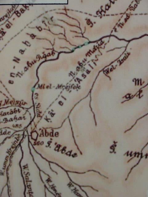
The Peshitta's notion that the border goes out _south of_ Rakim-gia (Aramaic rakim means "holy" which in Hebrew is qadesh, English Kadesh) might allude to the border "turning" southwest beneath the southern slopes of Gebel es-Snab. That is to say, perhaps Arabic is preserving site names not only from Hebrew but other "later renderings" such as Aramaic (the Peshitta), Greek (the Septuaginta) and Latin (the Vulgate)? Could the border described as "going round Sena" be describing the border as Musil's Wadi Marra/Murra (Israeli Nahal Zin) which "goes around" the south side of Gebel es-Snab's south slope? Sela (Judges 1:36) which is associated with the Judah's south border _in addition to_ the ascent of Akrabbim, might be Musil's Mehreh al-'Asali, Ka el 'Asali, and Wai el 'Asali, this area being rendered on modern Israeli maps as "Zinnim," ESE of Sede Boqer.on the south side of Wadi Marra/Murra opposite Musil's Gebel es-Snab and east of Oboda (Musil's Abde).
Is the Pehitta's Rakim-gia perhaps preserved in Jebel Rekhmeh and Khirbet Rekhmeh to the north of Gebel Halaq (biblical mount Halak on Judah's south border?)? The border ascends south of Rakim-gia (Kadesh-barnea). From the Arabah valley the track to Beersheba does ascend toward Gebel Halaq and _south_ of Gebel Rekhmeh and Khirbet Rekhmeh (modern Israeli Har Rakhmah and Be'er Yeroham).
Brenton's English translation of the Greek Septuaginta (1851):
Numbers 34:3-5 (Septuaginta)
"And your southern side shall be from the wilderness of SIN to the border of Edom, and your border southward shall extend on the side of the Salt Sea eastward. And your border shall go round you from the south to the ASCENT OF ACRABIN, and shall proceed by Ennac, and the going forth of it shall be southward to Cades Barne, and it shall go forth to the village of Arad, and shall proceed by Asemona. And the border shall compass from Asemona to the river of Egypt, and the sea shall be the termination." (Sir Lancelot C. L. Brenton. The Septuagint With Apocrypha: Greek and English. Peabody, Massachusetts. Hendrickson Publishers. 1986 [1851. Samuel Bagster & Sons, Ltd. London]. ISBN 0-913573-44-2)
Ennac appears to be a misspelling for Sena, however, I note a high plain on Musil's map called en-Nahabir east of Qa el-'Asali and north of Abdeh (Oboda). Musil has a diacritical under the h which would render en-Nahabir as en-Nakhabir, perhaps the Septuagint's Ennac?
Joshua 15:1-4 (Septuaginta)
"And the borders of the tribe of Juda according to their families were from the borders of Idumaea from the wilderness of SIN, as far as Cades southward. And their borders were from the south as far as a part of the Salt Sea from the high country that extends southward. And they proceed before the ASCENT OF ACRABIN, and go out round _SENA_, and go up from the south to Cades Barne; and go out to Asoron, and proceed up to Sarada, and go out by the way that is west of Cades. And they go out to Selmona, and issue at the valley of Egypt; and the termination of its boundaries shall be at the sea: these are their boundaries southward."
The TANAKH ( Philadephia. The Jewish Publication Society. 1988)
Numbers 34:3-5 (TANAKH)
"Your southern sector shall extend from the wilderness of Zin alongside Edom. Your southern boundary shall start on the east from the tip of the Dead Sea. Your boundary shall then to pass south of the ascent of Akrabbim and continue to Zin, and its limits shall be south of Kadesh-barnea, reaching Hazar-addar and continuing to Azmon. From Azmon the boundary shall turn toward the Wadi of Egypt and terminate at the Sea."
Joshua 15:1-4 (TANAKH)
The portion that fell by lot to the various clans of the tribe of Judah lay farthest south, down to the border of Edom, which is the wilderness of Zin. Their southern boundary began from the tip of the Dead Sea, from the tongue that projects southward. It proceeded to the south of the Ascent of Akrabbim, passed on to Zin, ascended to the south of Kadesh-barnea, passed on to Hezron, ascended to Addar, and made a turn to Karka. From there it passed on to Azmon and proceeded to the Wadi of Egypt; and the boundary ran on to the Sea. That shall be your southern boundary."
Judges 1:36 (TANAKH)
"The territory of the Amorites extended from the Ascent of Akrabbim -from Sela- onward."
Mount Halak is noted as part of Israel's south border as "one goes up to Seir" (Josh 11:17; 12:7). Perhaps Halak is the modern Israeli Har Haluqim ENE of Sede Boqer, Musil's Gebel Halaq, west of Gebel es-Snab. Could perhaps the statement "as one goes up to Seir" allude to the track which passes to the south of Gebels Halaq and es-Snab across the Mehreh al-'Asali to Edom, the track known in Arabic as the Darb es-Sultan, "way of the King" be what is being described? A message was sent from Kadesh by Moses asking permission to use the "King's Highway" (Nu 20:14-16) might this be the Darb es-Sultani? Or, does "goes up to Seir" refer to the track ascending from Gebel Halaq past Gebel Rekhmeh (modern Israeli Har Rakhma) to Ras es-Sirr (to the mountain pass plain called by the Israelies Mesad Sorer) west of modern Dimona what is meant? That is to say Seir is Ras es-Sirr? At Ras es-Sirr the ascending track from Gebel Halaq (Israeli Har Halaqim) turns to enter the Beersheba drainage basin and continue towards Arad. Is the Peshitta's Rakim-gia Khirbet Rekhmeh and Kadesh-barnea?
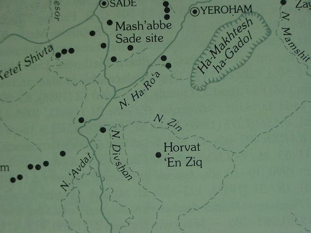
If the wilderness of Zin by Edom's border _demands_ a location "near the eastern periphery" of the mountain chain extending WSW from the Dead Sea's lower bay, allowing Nagb es-Sfar (Sfai) to be "preserving" the Aramaic Sepharvaim of the Peshitta (Ascent of Akrabbim), the _only_ location REMOTELY RESEMBLING Zin/Sena is, _for me_ Musil's Gebel es-Snab(modern Israeli Har Rekhev, the Arabic Gebel Rakib as preserved by T. E. Lawrence's map accompanying his book The Wilderness of Zin 1915). On modern Israeli maps the plain below this mountianous headland (Israeli Har Rekhev, Musil's Gebel es-Snab) is labeled Midbar Zin after the Hebrew for "wilderness of Zin" (cf. Map of Israel. Jerusalem. Survey of Israel. 1:250,000. 1979). The "strange" thing about Musil's map is the _absence_ of Gebel Rakib, _in its place is_ Gebel es-Snab_, however, he does list a Wadi Rakeb just ENE of Snab, draining from Koz ab al-Ershi.
Could Hazar-addar the "enclosed walled yard" [of] Addar (Strong's Bible Concordance nos. 2692 & 2691) be the _walled_ Iron Age II fortress and adjacent settlement of Ain Qudeirat in the Negev? Karka, Hebrew qarqa meaning "ground floor" is describing a geographical feature, the plain wadi el Ain descends into south and west of Ain Qudeirat, this wadi "circling about to" Ain Qusaima, possibly Azmon, (Asemona of Vulgate) and Qesam of the Targums? The River of Egypt is Wadi Muweilah as it passes the southern slopes of Gebel Mushraq, which preserves the Hebrew Mitzraim or Misraim "Egypt", Neo-Assyrian annals speak of the "river of Egypt" as Nahal Musri, noting it has no water (the Wadi el Arish). From the vicinity just north and west of Mushraq Wadi Muweilah becomes Wadi El Arish which becomes one stream all the way to the Mediterranean Sea. Gebel Mushraq being the last mount at Judah's south border, perhaps passed its name on to the river.
The southern border, essentially is following wadies till the slope of Mehreh al-'Asali (Sela?) is reached. From the end of the Dead Sea's south bay we follow Wadi Fiqre WSW along the low mountains extending WSW to Ain Qusaima (Azmon, the Targum's Qesam). Fiqre becomes wadi Marra/Murra which "turns" at Gebel es-Snab (Zinah/Sinah/Sena?) to drain the plain about Sede Boqer south of Gebel Heleqim (Mount Halak?). Then we ascend the mountains to Hazar-addar at Ain el Qudeirat, then it -the border- follows Wadi el Ain to the plain ("ground floor" or qarqa/karka) and Ain Qusaima (Azmon/ Kesam of the Targums). Then the wadi becomes Wadi Muweila and it passes and turns the south slope of Gebel Mushraq which I suspect preserves the name Mitzraim rendered in English as "Egypt".
The "ascent of Akrabbim" has probably been correctly identified by scholars as Nagb es-Sfar, perhaps preserving the Aramaic rendering found in the Peshitta, "the ascent of Sepharvaim".
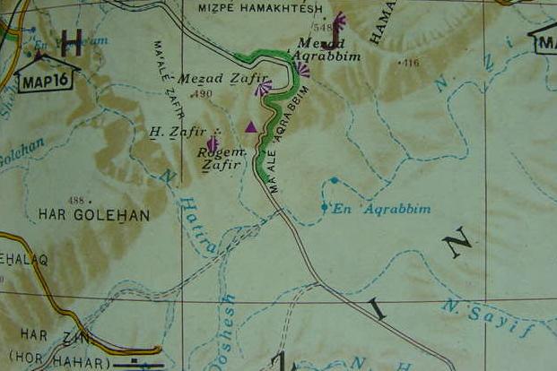
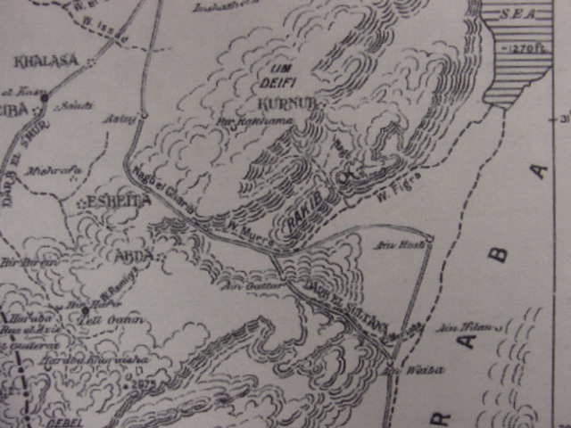
Below, a map of "the Ascent of Akrabbim", Arabic Nagb es-Sfar (Safar/Sfai/Safa) and its way stations from Nabatean and Roman times rendered in Israeli as Hirbat Zafir and Rogem Zafir and Ma'ale Zafir. Apparently a modern paved highway to the E of the ancient ascent has been made by the Israelies ("Map of Israel". Survey of Israel. Jerusalem. 1:250,000. 1979, appearing in Avraham Levi. Bazak Guide to Israel, 1979-1980. Jerusalem. 1979.)
Below, Har Rekhev, the Arabic Gebel Rakib on T. E. Lawrence's above map ("Map of Israel". Survey of Israel. Jerusalem. 1:250,000. 1979, appearing in Avraham Levi. Bazak Guide to Israel, 1979-1980. Jerusalem. 1979.). B and V are interchangeable consonants between Hebrew and English, Avraham is Abraham, Negev is Negeb. The track noted by brown dotted lines, bypassing the south slope of Har Rekhev, appears to be Lawrence's Darb el Sultana "way of the king", cf. the above map.
Seely noted that in the Massoretic Text Zin is rendered in Hebrew as sin-ah (with diacritical dot under s) in Numbers 34:4 and Joshua 15:3. Of interest is that some variants of the Greek Septuaginta (LXX) rendered Zin as either Sena and Senna.
Seely:
"In both Numbers 34:4 and Joshus 15:3 the name "Zin" occurs with the locative -ah in a context that suggests a distinction between Zin [sin-ah] and the Wilderness of Zin. Some have interpreted these passages as evidence that there was a specific place, located between Kadesh and the ascent of Akrabbim, named Zin from which the wilderness derived its name." (p. 1096. Vol.6. David R. Seely. "Zin, Wilderness of." David Noel Freedman, Editor. The Anchor Bible Dictionary. New York. Doubleday. 1992. 6 vols.)
Professor Kallai on _the locative_ or noun ending "-ah" appended to Luz (Hebrew Luzah):
"In the biblical text the name of the city, Luz, twice appears in the form of "Luzah": "And the border went over from thence to Luz (Luzah), to the shoulder of Luz (Luzah) southward, which is Beth-el". In the first case, the noun-ending "-ah" may be explained as locative, denoting direction; but its use in the second case is not explained. It may therefore, be assumed (see below, note 217) that, as in the cases of other names that appear in both forms -sometimes with the noun-ending and at other times without it- this does not invariably connote direction. Thus this line of reasoning one will see as self-explanatory the verse in Joshua xvi:2: "And goeth out from Beth-el Luzah". In other words, the intention is to define the place by both of its name rather than to state that the border went out of Beth-el to Luz." (p. 130. "Benjamin's Allotment." Zecharia Kallai. Historical Geography of the Bible, The Tribal Territories of Israel. Jerusalem-Leiden. The Magness Press. Hebrew University. E.J. Brill. 1986)
Flavius Josephus (1st century CE/AD) suggested that Zin was a mountain:
"Then it was that Miriam, the sister of Moses, came to her end...She was buried upon a certain mountain, which they call Sin..." (Flavius Josephus. Antiquities of the Jews. Chapter 4, verse 6).
Could the "mountain of Zin/Zin-ah/Sena be Gebel es-Sna [b]? If so, then the Israelis have correctly located the "wilderness of Zin" as the plain abutting the south slopes of this mountainous headland. Their error is in identifying an elevation in the plain near Wadi Marra/Murra as being "Har Zin", Flavius Josephus' "Mount Sin", cf. the above "Map of Israel" showing the "ascent of Akrabbim," where Har Zin appears in the lower left corner of the map.
Some may be "wondering" about the "-b" appended to es-Snab. Aharoni in his chapter on toponymns noted that sometimes the Hebrew name may be "hiding" due to prefixes, suffixes and sufformatives appended to the name at a later time, one must look for the "root" word, in this case, _I suspect_ that -sna- is the root preserved in Arabic from probably the Greek Septuaginta and Latin Vulgate Sena (cf. pp. 105-130."The Study of Toponymy." Yohanan Aharoni. The Land of the Bible, A Historical Geography. Revised & Enlarged Edition. Philadelphia. Westminster Press. 1979 [1962, 1967]. ISBN 0-664-24266-9. paperback).
Azmon is rendered in the Tarqum as kesam/qesam and is recognizable in its root as 'sam, modern Ain Qusaima. Perhaps Hazar-addar "the walled/fenced yard [hamlet]" or hazar of Addar is hidden by Ain el Qudeirat, the root being -'deir-, a prefix/suffix (?) and sufformative (?) have hidden the word? Ain Qudeirat has a "walled/fenced" Iron Age II fortress and a nearby settlement of the same era. Excavations revealed that originally the fortress' walled or fenced "yard" was elliptical and of stone, later this was built atop of by a rectangular stone wall.
Now, if the wilderness of Zin is the drainage plain below the slopes of Gebel es-Snab, could it be that Israel's camp called Kadesh-barnea lies somewhere in this plain? If Josephus has related correctly Israelite traditions of Moses burying his sister Miriam on a mount called Sin (Sin-ah), and if Gebel es-Sna[b] is this mount, why not locate Kadesh in this plain or nearby slope? It would be admirably sited for those arguing that Edom's border is the wilderness of Zin adjacent to the eastern permiter of the mountains bordering the Arabah, and Moses did send a message to the Edomites stating Israel was encamped _in their_ border (the wilderness of Zin), and sought permission to use the King's Highway (Nu 20:14-17) which was apparently "near" the Israelite camp at Kadesh.Could the Darb el Sultani/Sultana, a track passing south of the slopes of Gebel es-Snab/Rakib be "the king's highway"? If Kadesh is near the Darb el Sultan and near Gebel es-Snab (Mount Zinah/Sena?) then this is the area to look for Kadesh-barnea, _not_ in Ain el Qadeis or Ain el Qudeirat which lie much further south of the Darb el Sultan (some 50 kilometers or 30 miles away). The "problem" is that some scholars understand that "the king's highway" was a track running the length of Edom, from north to south rather than from Kadesh in the Wilderness of Zin through Edom (the Arabah and mountains east of this rift valley).
Glueck speaking of the biblical King's higway Israel requested permission to use form Kadesh in the wilderness of Zin, in Edom, being later superceded by the Roman highway built under the Roman emperor Trajan and now called the Darb es-Sultani:
"Its counterpart in Transjordan is the Tariq es-Sultani (the "Road of the Sultan"). In many places it runs next to or directly over the road built by Trajan from Damascus to Aila, which in turn, superceded the Derech ha-Melekh (the "King's Way") of the Bible." (pp. 32-33. Nelson Glueck. Rivers in the Desert, A History of the Negev. New York. Farrar, Straus & Cudahy. 1959)
Professor Bailey has suggested that Ain el Kadeis (ain el Gades on earlier 19th century maps), might preserve the Arabic word kadus, meaning a "covered stone drinking trough" for animals, noting such an item exists at this location. Thus, he suggests this might not be Kadesh-barnea.
Kadesh-barnea appears to be rendered under several different names, Kadesh, en-Mishphat ("the well of judgement"), the "waters of meribah-kadesh," and it is located in "the wilderness of Zin" (LXX: Sena) as well as the "wilderness of Paran." Water is limited upon the arrival until Yahewh provides water via Moses striking a rock.
I have the following proposals to make:
Moses while at Kadesh is asked to provide water for his people. God tells him he will provide water from a "rock," called _sela_ in Hebrew (cf. Strong's Hebrew & Chaldee Dictionary #5553). Moses takes his rod and strikes sela TWICE, water gushes forth. The location is then called "the waterS of Meribah" (derived from a root, -riyb Strong # 7378, meaning to quarrel or wrangle). Perhaps sela is preserved at Mehreh al 'Asali, opposite and WSW of Gebel es-Snab (Zin-ah/Sinah). This elevation is probably also the "Sela" mentioned as a part of Israel's south border in conjunction with the ascent of Akrabbim (Judges 1:36).
Judges 1:36 TANAKH (1985)
"The territory of the Amorites extended from the ascent of Akrabbim -from Sela- onward."
Musil shows water sources in blue ink. My what a thorough explorer he was, doing all this back about 1907-1908! I note TWO blue dots on the slope opposite Gebel es-Snab (Mount Zin?) they are called Mi esh-Shabijje. Could these be the TWO wells created by Moses having struck "Sela" TWICE with his rod? Curiously after the incident we are informed these are the waters of Meribah-kadesh. Waters to me suggests TWO water sources not one, the two strikes with the rod creating them in perhaps a "folk-etymology"? The "Sela" Moses struck is perhaps preserved in Mehreh al-'Asali? Is this also the Sela mentioned in Judges with Acrabbim, marking the southern border?
Could Meribah be preserved in two nearby sites, Mehreh and Ka'ab (Mehreh al-'Asali and Gebel umm Ka'ab that lie near each other?). The waters of Meribah would be the two wells (?) bounded by Mehreh-Ka'ab? Is Barnea preserved at Wadi el Bared, just east of the two wells (Musil's Mi esh-Shabijje)?
When Lawrence's 1915 map showing the route of the Darb el Sultana is compared with Musil's 1908 map of Gebel es-Snab, Mehreh al-'Asali and Mi esh-Shabijje, it appears that "the king's highway," if it is the Darb el Sultani (Nu 20:14-17), Israel wants to take is very near Kadesh-barnea, that is, if my hunches are correct that Kadesh lies near Mi esh-Shabijje and opposite Gebel es-Snab (Josephus' mount Zin/Sena?). We are told Moses' sister Miriam dies at Kadesh in the wilderness of Zin (Nu 20:1) and Josephus said Zin/Sin was a mountain that she was buried on. Gebel esh-Snab certainly qualifies as a mountain. And it lies in the "eastern" perimeter of the mountains bordering the Arabah, and it is to the south of the ascent of Akrabbim, commonly associated with Nagb es-Sfar (Safa, Sfai).
If this is the location of Kadesh-barnea then the statement that the border passed up south of Kadesh to Hazar-addar may mean that Kadesh lying on the lower slopes of Mehreh al-'Asali and Gebel umm Ka'ab, is having the border _ascend_ still higher to the northwest rim of the wadi Rumman erosion crater, where it continues till it reaches Ain el Qudeirat, which I suspect is Hazar-addar. Iron Age sites do abound in this high country up to the north edge of the erosion crater and they do extend to Ain el Qudeirat.
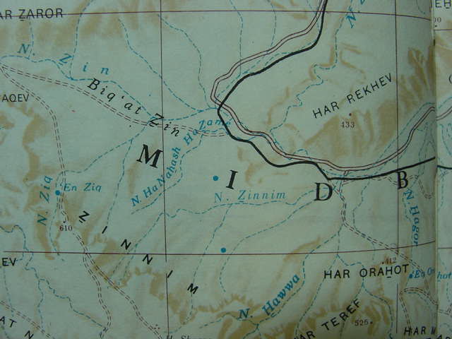
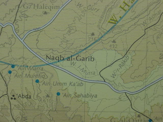
Below, a modern Israeli map made by the Survey of Israel, Jerusalem (1979) showing the "Wilderness of Zin" rendered in Hebrew as Midbar Zin, extending from just ESE of Sede Boqer, and arcing to the ENE towards the Dead Sea and the "ascent of Aqrabbim" (Nagb es-Sfar, Israeli Zafir).
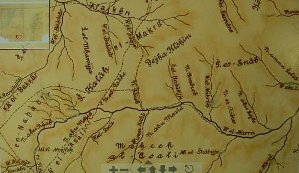
Below, Musil's Gebel es-Snab, Arabic Gebel Rakib, modern Israeli Har Rekhev, which "might be" Josephus' Mount Zin/Zinah, the Greek Septuaginta's Sena? His Gebel Halak I suspect is biblical Mount Halak which according to Bible was also part of Israel/Judah's "southernmost" border.(Alois Musil. Karte von Arabia Petraea. Wien [Vienna]. 1:300,000. 1908). If you should desire to explore the below map further, zooming in and out of "other locations" in the Negev from the Dead Sea to Halaq and points further south including the Arabah valley, please click on the following url:http://mapy.vkol.cz/mapy/v61955_002.htm
After clicking on the preceeding url, by clicking on the + (plus sign) you can enlarge the map repeatedly to pick up tiny details, by clicking on the - (minus sign) you can reduce the map's size and get an overview of the whole of the Arabah and Negev. By clicking on the arrows you can navigate the map going north, south, east and west. You can choose any sector of the map to look at by placing your cursor over the area you want and then click repeatedly to enlarge it. Its an amazing _interactive_ map! Note: Nothing will happen if you click on the below map, you _must_ click on the above url which will present you the interactive map.
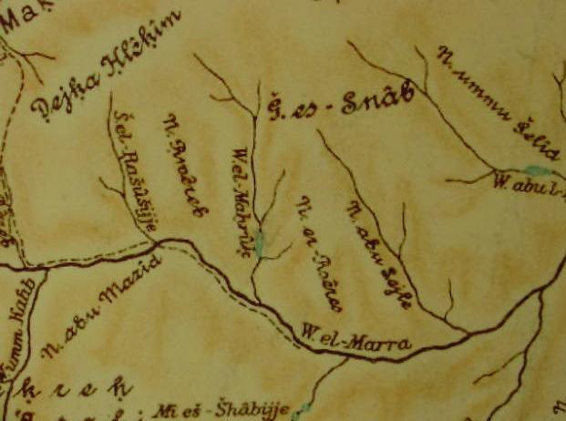
A "close-up of the above map showing Gebel es-Snab (Lawrence's Gebel Rakib, Israeli Har Rekhev). Blue areas are apparently wells or springs or water catchments after rains.
Below Gebel Rakib on T. E. Lawrence's map accompanying his book, The Wilderness of Zin. London, 1915. He shows a track starting near ain Weiba in the Arabah valley called the Darb el Sultana (Nelson Glueck's Darb es-Sultani. cf. pp. 228-229, Rivers in the Desert. 1959) which passes along to the south of Gebel Rakib, along the southside of Wadi Murra, becoming in the vicinity of Musil's Gebel Halak, the Nagb el Gharib "ascent of Gharib," which goes on to Asluj and Beersheba. Note also the Nagb Sfar ascending from Wadi Figra, Musil's Wadi Fikre to the ENE of "Rakib" (Musil's Gebel es-Snab, and a Wadi Rakeb to its ENE). Note: Lawrence's Bir Rakhama appears on other maps as Rekhmeh, modern Israeli Be'er Yehroham (pronounced Yehrokham).
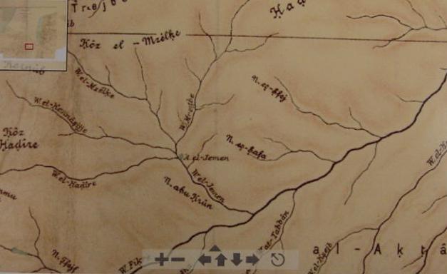
Below, Musil's map showing a Nagb es-Safa "ascent of Safa" and nearby a Nagb es-Sfej (Sfei), ENE of Wadi el-Jemen (the above Israeli Nahal Hatira) which drains into Wadi Fikre (Israeli Nahal Zin) from the erosion crater called by Israelies Hamakhtesh Hagadol. Strangely _missing_ from Musil's map is a Nagb es-Safr (Is it "subsumed" by scholars under Nagbs Safa and Sfej?). Musil shows Wadi el-Hadire (whence the Israeli Nahal Hatira) to be a headwater west of Wadi el-Jemen draining from Koz el-Hadire, on far left of the map. Could the track following Wadies Marra/Murra and Fiqre (Nahal Zin) be "the way of Atharim"? Again, "-im" is plural and two erosion craters each provide a wadi whichs empties into Wadi Fikre. Thus Arabic Hadire (Israeli Hatira) preserves the "two" Atharim erosion craters, Musil's Koz al-Hadire and ENE of this location Hadirt al-Gebu (two heights adjacent to the craters), that is to say, the heights of Hadire and Hadirt may be the Atharim? Israel, is then, skirting Edom's western border below the hieghts of the mountains extending WSW from the Dead Sea?
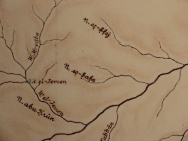
Below, a "close-up" of Nagb es-Safa and Nagb es-Sfej from the above map. Strangely "missing" from this map is a Nagb es-Sfar.
If the "ascent of Akrabbim, the Aramaic Peshitta's "ascent of Sepharvaim," is preserved in Nagb es-Sfar (Sfa, Safar, Sfei?), and If Zin (Hebrew Sin-ah, with diacritical dot under the S), the Greek Septuaginta's Sena, is Gebel es-Snab (Israeli Har Rekhev), then Kadesh-barnea is "most probably" somewhere in this area. Sela, associated with Israel's south border (Judges 1:36) is, perhaps, Musil's Mehreh al-'Asali or Qa el-'Asali N of Oboda. The "rock" or _sela_ struck by moses at Kadesh may also be preserved at 'Asali or _even_ Wadi el-'Asali (?), that is to say, the Arabic may be preserving quite literally in this wadi's name: "a river from the sela (rock)," a headwater of Wadi el-Marra (Wadi el-'Asali is just west of Mehreh al-'Asali and drains from Ka' el-'Asali, north of Oboda, Musil's Abde, Israeli 'Avedat). If this "hunch" is correct, then Kadesh-barnea is perhaps near Oboda and the Qa el-'Asali. If Sela is the vicinity of Nagb es-Sfar, could this be a "euphemism" for the "high-rocky" mountainous mass that extends WSW of the Dead Sea? That is to say the ascent is climbing "the high-rock" (the mountainous heights)?
The "king's highway" which was apparently "near" Kadesh, if it is the Darb el Sultani, crosses between 'Asali (Sela?) and es-Snab (Sena?) and passes under the south slopes of Gebel Halak, another site on Israel's south border. Most scholars locate Kadesh at either Ain el Qadeis or the nearby Ain el Qudeirat, which are 30 miles or 50 kilometers south of the Darb el Sultani (the king's highway?). By placing Kadesh-barnea in the area of "Asali and es-Snab," that is to say a "region" demarcated by Oboda on the West and its Qa el-'Asali and Wadi el-'Asali, Gebel Halak and Sede Boqer on the north, Gebel es-Snab (mount Zinah/Sena?) on the east and Mehreh al-'Asali on the south, all of which are _near_ the Darb el Sultan or "king's highway," we are _much closer to_ the "king's highway and actually have a site for Kadesh _within_ the Israeli map's rendering of "Midbar Zin." Josephus' "mount" Sin where Miriam was buried might be preserved at Gebel es-Snab? Hazar-addar might be the Iron II fortress at Ain el-Qudeirat?
I realize there are "a lot of ifs, might's and maybe's presented here," but that's the nature of proposals for sites in Israel's borders.
Below, is Kadesh-barnea to be located at the beginning of Wadi el-'Asali ("the river of the rock"?), which begins at Abdeh (Oboda) the site where Moses struck the _sela_ with his rod to provide water for his people? Or is Kadesh somewhere on the Qa el-'Asela around which flow the headwaters of Wadi Marra/Murra? Let it be said here that I am _not_ a believer in the Bible being God's word. For the reasons why please click here. I "suspect" that the Hebrews are engaging in some "folk-etymologies." That is to say, no river of water flowed from Moses' rod to sustain thousands of Israelites and their flocks and herds. Perhaps a landform whose name (''asali") resembled a Hebrew word like sela, caused a "creative mind" to concoct a tale to explain the geographical feature? Thus "the river of the rock" or "waters of the rock" became an inspired story of how God provided water in the wilderness of Zin for his people via the wadies or springs in area between 'Asali (Sela?) and Snab (Sena/Zinah?) ?
Below, Gebel Haleqim, possibly biblical Mt. Halak on Israel's south border (Josh 11:17, 12:7) is in the upper left corner. Below Wadi er-Rakib is the mountainous promontory identified by Musil with Gebel es-Snab (my proposal for Mount Zin/Zinah/Sena). The drainage basin about Gebel es-Snab is perhaps the "wilderness of Zin"? If so, then Kadesh-barnea should be "somewhere" within or near this basin. The Darb el Sultan appears to come to its end in the midst of the Zin drainage basin under the slopes of Gebel es-Snab. The road as it "ascends" from the basin, past Har Halaqim (Mount Halak?) comes to be called Nagb Gharib, the ascent of Gharib. If the Darb el Sultan is the "king's highway" Israel sought to embark upon from Kadesh, perhaps this site is near the end of this route, in the Zin drainage basin? (cf. map titled "Palastina um 1920, Sudteil." Siegfried Mittmann & Gotz Schmitt. Gottinger Bibelatlas. Stuttgart. Deutsche Bibelgesellschaft. 2001. ISBN 3-438-06022-1).
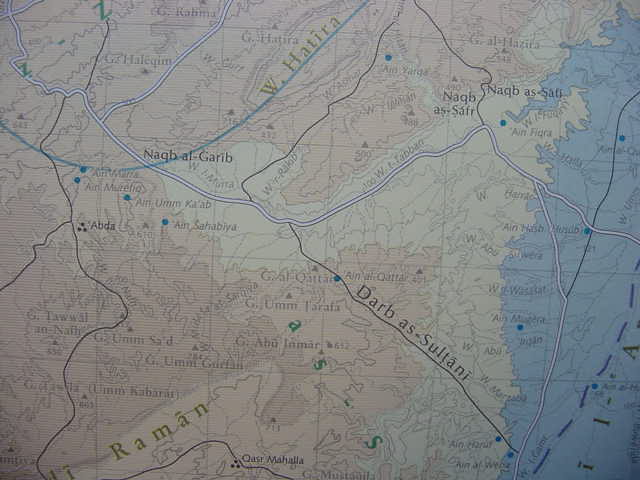
Below, a larger panoramic view of the above map showing the Darb el Sultani, the biblical "king's highway" (?) Israel asked to use from Kadesh in the wilderness of Zin (Nu 20:14-17) bypassing the southern slope of Musil's Gebel es-Snab. The ascent of Akrabbim identified by some scholars with Nagb es-Safr (Sfar/Sfei/Safi), is to ENE of Gebel es-Snab (Israeli Har Rekhev). The white lines represent modern highways, black lines are ancient dirt tracks.
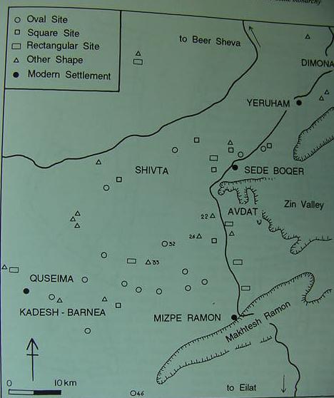
The below map of Iron Age II sites in the Negev do not appear to extend into the Nahal Zin drainage basin. They "circle" the basin as the higher elevations possess soils and water permitting settlements. There might be another reason why there are no settlements, perhaps this drainage basin is the arid, inhospitable wilderness of Zin in which is located Moses' encampment of Kadesh-Barnea? As Kadesh was said to be "in" Edom's border, this area may not not have been settled by Israel (Nu 20:16)? (cf. p. 1126. Vol. 3. Rudolph Cohen. "Map of the main Iron Age sites in the Negev Hills." Ephraim Stern. Editor. The New Encyclopedia of Archaeological Excavations in the Holy Land. New York. Simon & Schuster. 1993)
The below Map of Intermediate Bronze Age (Early Bronze IV- Middle Bronze I, circa 2200-2000 BCE) sites for the Negev shows "only" one archaeological site in the drainage basin of Nahal Zin, the settlement at 'En Ziq. Grinding stones and querns suggest some farming activity in this location. A few graves were also found (cf. p. 1124. RudolphCohen. "Map of the main MB I sites in the Negev Hills." Ephraim Stern. Editor. The New Encyclopedia of Archaeological Excavations in the Holy Land. New York. Simon & Schuster. 1993).
Finkelstein mentions that the area about Sede Boqer was settled in Iron Age II from about the end of the 11th to the end of the 10th century BCE then vacated. The settlements suggest herding of sheep and goats and surprisingly "small cattle" as well. This recalls for me Israel's complaint to Moses at Kadesh in the wilderness of Zin that there is no water for them or their cattle (Nu 20:1-5). Apparently in Iron Age II small cattle were raised on the periphery of the Nahal Zin drainage basin at the higher elevations. If I am reading Finkelstein correctly, herds of cattle were being raised in the Negev by Bedouin as late as the early 20th century.
Finkelstein (emphasis mine in capitals):
"Animal husbandry is evident from the large central courtyards at the main sites, which most probably served as animal pens (Haiman 1988:86-87), and from the osteological finds. The latter, although sparse, REVEAL c. 85% OF SMALL CATTLE (Cohen 1986a:395-401), a number which closely corresponds TO DATA ON HERDS of the Bedouin of the Negev at the beginning of this century (Sawer 1926)." (p. 62. "Subsistence patterns and carrying capacity: The Negev Highlands as a case study." Israel Finkelstein. Living on the Fringe, the Archaeology and History of the Negev, Sinai and Neighbouring Regions in the Bronze and Iron Ages. Sheffield, England. Sheffield Academic Press Ltd. 1995, 2001. ISBN 1-85075-555-8)
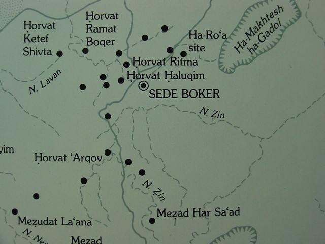
Below, a map of the Iron Age II "fortresses" in the Negev, Note: Finkelstein's "Zin Valley" is the drainage basin of the Nahal Zin, Arabic Wadi Marra or Murra. Avdat is Israeli for the site of Nabatean Oboda or Abdeh. The small circle just north of Sede Boqer is an elliptical Iron Age II fortress with an accompanying village called today Har Halaqim, which I understand to be Mount Halak of the Bible, Joshua's southernmost conquest. If Kadesh is not in the drainage basin of Nahal Zin could it be the settlement and fort at Har Halaqim? That is to say, Joshua's conquest ended at Mount Halak because this was where Kadesh Barnea had been located, a place from which she had failed to conquer the Promised Land on an earlier attempt. (cf. p. 105. "General Map of the Negev Highlands "fortresses".Israel Finkelstein. Living on the Fringe, the Archaeology and History of the Negev, Sinai and Neighbouring Regions in the Bronze and Iron Ages. Sheffield, England. Sheffield Academic Press Ltd. 1995, 2001. ISBN 1-85075-555-8).
Finkelstein on the Iron Age II "subsistence patterns" found in the Sede-Boqer area adjacent to the Nahal drainage basin:
"The subsistence strategy of the Iron Age population is revealed both by the settlement pattern and by the results of excavations in the Sede-Boqer area (Meshel 1974a; 1077; Cohen 1970; 1976; 1986a:314-401) as well as in other parts of the Negev highlands.
The fact that most Iron Age sites are located near cultivable valleys indicates the importance of dry-farming in the subsistence economy of the population. Intensive grain growing activity is also indicated by the large number of grinding stones and sickle blades found at all sites excavated (Cohen 1986a:395). In addition, there are traces of Iron Age dams and terraces (Cohen 1986a:355), silos and threshing floors (Haiman 1989:21, 51-52)." (p. 62. "Subsistence patterns and carrying capacity: The Negev Highlands as a case study." Israel Finkelstein. Living on the Fringe, the Archaeology and History of the Negev, Sinai and Neighbouring Regions in the Bronze and Iron Ages. Sheffield, England. Sheffield Academic Press Ltd. 1995, 2001. ISBN 1-85075-555-8).
"The pottery retrieved from excavations shows that the period of the wave of Iron Age sedentary activity in the Negev Highlands was relatively short -not earlier than the last phase of the 11th century BC and not later than the late 10th century (cf. Finkelstein 1984 for bibliography). Therefore, it is not impossible that most of the sites were inhabited contemporaneously. Accordingly, the sedentary population can be estimated at about 300 individuals, or about 400-450 counting pastoralists who are not represented in the material remains.
The Iron Age population was therefore close to the carrying capacity of the area in a dry-farming-herding model, or even slightly above it." (p. 63. "Subsistence patterns and carrying capacity: The Negev Highlands as a case study." Israel Finkelstein. Living on the Fringe, the Archaeology and History of the Negev, Sinai and Neighbouring Regions in the Bronze and Iron Ages. Sheffield, England. Sheffield Academic Press Ltd. 1995, 2001. ISBN 1-85075-555-8).
Conclusions (08 Jan 2006):
I suspect that Kadesh-barnea has not yet been identified. I have finally accepted the Nagb es-Sfar as probably being the "ascent of Akrabbim," the Aramaic Peshitta Bible's "ascent of Sepharvaim" (Nu 34:4-5) and argued its plural form "-im" may be alluding to the three sites of Rugm Sfar, Khirbet Sfar, and Qasr Sfar, which are Nabatean in origin and Roman-Byzantine in repair, about the same era as the Peshitta's creation.
I have also argued that "the king's highway" which Moses requested permission of Edom to use after setting up camp at Kadesh-barnea, in the wilderness of Zin (Nu 20:14-17), may be the Darb el Sultani, "the king's way," which extends from Ain Weibeh in the Arabah to the Nahal drainage basin (Finkelstein's "Zin Valley") ending beneath the slopes of Musil's Gebel es-Snab.
The "only" topnymn bearing a form _remotely resembling_ the Hebrew Zin or Sinah (S with a diacritical dot under it) that I can find near the eastern perimeter of the mountains extending WSW from the Dead Sea and the "ascent of Akrabbim," the Nagb es-Sfar, is Musil's Gebel es-Snab (1908 Karte von Arabia Petraea. Wein [Vienna, Austria]). I have accordingly proposed this mount is probably Flavius Josephus' Mount Zin, where Moses' sister Miriam was buried.
If Kadesh-barnea is not in the Nahal Zin drainage basin, perhaps it is the Iron Age II (late 11th to late 10th century BCE) elliptical fortress and accompaning village appearing on Israeli maps as Horvat Haluqim, cf. the above map of Iron Age settlements in the Negev (p. 1126. Vol. 3. Rudolph Cohen. "Map of the main Iron Age sites in the Negev Hills." Ephraim Stern. Editor. The New Encyclopedia of Archaeological Excavations in the Holy Land. New York. Simon & Schuster. 1993) just to the NW of the modern Israeli settlement of Sede Boker (Boqer). An extension (?) of the Darb el Sultani called the Nagb Gharib passes by this site, on its way to Beersheba via Asluj.
I have proposed that Israeli Har Haluqim near Sede Boqer may be Joshua's Mount Halak, his furthest south conquest, and this mount lies very near the Nahal Zin drainage basin (the wilderness of Zin?).
The mention of "cattle" in the wilderness of Zin at Kadesh-barnea is borne out by the osteological remains ("bone remains") of so-called "small-cattle" in Iron Age II in the Sede-Boqer region which is adjacent to the Nahal Zin drainage basin. Did later 8th-6th century Judaeans wander into this area (Sede-Boqer and the Nahal Zin basin) and seeing the remains of Iron II settlements and pens of the late 11th-10th centuries BC identify them with Moses' Israelites and their "cattle" (Nu 20:1-5)?
Numbers 20:1-5, 14-17 RSV
"And the people of Israel, the whole congregation, came into the the wilderness of Zin in the first month, and the people stayed in Kadesh; and Miriam died there, and was buried there. Now there was no water for the congregation; and they assembled themselves together against Moses and against Aaron..."Why have you brought the assembly of the Lord into this wilderness, that we should die here, both we and our cattle? And why have you made us come up out of Egypt, to bring us to this evil place? It is no place for grain, or figs, or vines, or pomengranates; and there is no water to drink."
...And Moses lifted up his hand and struck the rock with his rod twice; and water came forth abundantly, and the congregation drank, they and their cattle...These are the waters of Meribah, where the people of Israel contended with the Lord, and he showed himself holy among them...Moses sent messengers to the king of Edom...we are here in Kadesh, a city on the edge of your territory, now let us pass through your land...we will go along the King's Highway...until we have passed through your territory."
I have noted that the Israeli scholars have suggested that the Wilderness of Zin is to be found near the eastern periphery of the mountains extending WSW from the Dead Sea ENE of Sede Boqer. Yet most maps continue to identify Kadesh Barnea with either Ain el Qadeis or nearby Ain el Qudeirat. The problem? Neither of these locations lies in the eastern periphery of this chain of mountains. Instead they lie at the furthest west periphery of the chain (its very "end"), some 50 kilometers away (30 miles); any further west and one is in the great Wadi el Arish drainage basin, nowhere "near" the Wilderness of Zin if it lies ENE of Sede Boqer as portrayed on modern Israeli maps (cf. the above 1979 example).
Please click here for my article revealing that according to Egyptian Ramesside accounts cattle were indeed "herded" across the Sinai in the 13th century BCE by nomads from Edom, thus the possibility exists that Israel could herd her cattle in the reverse direction, from Egypt to Edom.
26 May 2006 Update:
Another possibility for the "ascent of Akrabbim" (Hebrew Aqrabbim) is the Arabic Nagb Gharib, "ascent of Gharib" which is west of modern Israeli Har Rekhev (Arabic Gebel Rakib). The Nagb Gharib appears to be an extension of the Darb el Sultani. On the above T. E. Lawrence's 1915 map this ascent is shown as ascending the mountains just to the east of Abda (Israeli Avdeh, Greek Oboda) and bypassing the southern slopes of Gebel Heleqim, heading for Asluj and Beersheba. "Against" the Nagb Gharib being Akrabbim is that the wilderness of Zin (Sena) is described in the Bible AFTER the ascent, whereas the Gharib is AFTER Gebel Snab. However if the wilderness is the drainage basin SW of Gebel Snab and Nagb Gharib, then the identity could be acceptable.
"If" Nagb al-Garib is the ascent of Akrabbim the "mystery" is by what phonological process did Arabic come to render Hebrew aq[rabbim] into gha[rib]? In favor of Nagb al-Gharib being the ascent of Akrabbim is that it is near Gebel Snab (Sena? Zin?) and it passes the southside of Gebel Haleqim believed to be the biblical Mount Halak which was part of Israel's border in the Negev (cf. Joshua 11:17; 12:7). Cf. the above maps for Nagb (Naqb) Gharib's location.
Special update of 13 January 2009:
Today I stumbled quite by accident over an article on the internet about a large Sumerian cemetery being investigated by archaeologists in Iraq. This area was known to the local natives as
umm el-Ajarib, "Mother of Scorpions."
I have noted that in English transliterations of Arabic words that sometimes j and g are "interchangeable" as for instance the Arabic word for "mountain" being rendered either Jebal or Gebal.
If we render Ajarib alternately as Agarib, could perhaps Nagb al-Garib be a dialectal form of el-Agarib, el-Ajarib? If this be so, then Nagb al-Garib is perhaps a dialectal Arabic rendering of Hebrew Akrabim, both words meaning "scorpions." So Nagb al-Garib is "the ascent of the scorpions" literally translated into Arabic from Hebrew? This would "align" with Sela, associated with the "ascent of Akrabim," as possibly being the nearby Ka (Qa) el-'Aseli, Wadi el-'Aseli and Mehreh al-'Aseli (Musil's 1907 map) on the lower southside of the Nagb al-Garib.
Another interesting observation:
Some of the above maps render Nagb, others Naqb, in other words, g and q appear to be interchangeable in English transliterations of Arabic words. Is it possible that Arabic al-Ajarib ("scorpions") is also renderable as not only Agarib but also Aqarib, q being an alternate rendering of g (recalling Jebal/Gebal and Nagb/Naqb)? I recall a map made in the 1940s rendering the port of Akaba as Agaba (today q is preferred over g and k as Aqaba). In the early 1900's ain el Qadeis was rendered as ein el Gades and ein Kades (q, g, k, being alternate renderings in English transliterations of Arabic words). All this is to say that "perhaps" the ascent of Akrabim (Aqrabim) is "hidden in plain view" on maps by different cartographers using differing phonological systems of vowels and consonants to render Arabic words or sounds into English? That is to say, the Ascent of Accrabim/Akrabim/Aqrabim is the Nagb/Naqb al/el Gharib/Garib/Qarib/Ajarib/Aqarib?
A Google internet search reveals that the Arabic word for "scorpions" can be rendered into English by using any of the following consonants: C, Q, K, J, or G: aqarib, akarib, acarib, ajarib, agarib.
Two examples of the G rendering by Ahmed and Smith:
al-agarib a'garib
"Relatives are scorpions" (177)
"This proverb is using the poisonous scorpion as a metaphor to criticise relatives who
cause problems and poison your life or turn it to hell."
Salwa Ahmed. Educational and Social Values expressed by proverbs in two cultures: Knowledge and Use of proverbs in Sudan and England. Doctor of Philosophy Dissertation. 2005. Technischen Universitat Berlin.
`agarib, which means both scorpions and 'curl,' Ibn Khallikdn.
Margaret Smith. Al Ghazi the Mystic. Al-Hijra Publishers.
(http://www.ghazali.org/books/smith-gz.rtf)
Judges 1:36
And the border of the Amorites ran from the ASCENT OF AKRABBIM, from SELA and upward."
Note: the text says from Sela and "upward." Perhaps upward means that the ascent is "above" the Sela just as Nagb al-Garib is "above" (a higher elevation) the Qa el-'Asali, Wadi el-'Asali and Mehreh el-'Asali ?
The "break" in the mountain chain extending southwest of the Dead Sea is at the Nagb al-Garib, and this break, traversed by the Garib, would be a naturally occuring "physical feature" of Judah's southern border.
Moses apparently while at Kadesh-Barnea requests of the king of Edom, permission to cross his land. Moses tells him that Israel will use the "King's Way" to cross Edom but Edom refuses passage. Of interest here is that some scholars have suggested the "Kings' Way" is the Arabic Darb es-Sultani (Way of the Kings), a track starting near the Naqb Gharib and heading eastwards for Edom on the east side of the Arabah valley.
In another passage Moses strikes a "rock" rendered in Hebrew sela (Nu 20:10; Strong 5553 "cela", seh'lah, Hebrew and Chaldee Dictionary) and water comes forth from the sela to provide water for Israel and her cattle in the Wilderness of Zin. Is it possible that the sela Moses struck is a play on words of the Sela near the ascent of Aqrabbim? That is to say the Arabic 'Asali preserves the sela that water came forth from in the form of Wadi el-'Asali (Musil's 1907 map titled Karte von Arabia Petraea)? The area where the sela was located was suppossed to be without water, hence Israel complaining they and their herds had no water to drink. The arid Mehreh (Mekreh?) el 'Asali south of the Nagb al-Gharib/Garib would fit the arid wilderness description of Zin. The modern Israelis locate the Wilderness of Zin in this very area on modern maps.
Another passage speaks of Joshua's conquests in the Negeb reaching as far south as mount Halak (Jos 11:17, 12:7). If this is Gebel Halaq on Musil's map, I note that the Nagb al-Garib turns north and runs parallel to the east side of Halaq (the Nagb al-Garib is between Halaq on its west and Gebel Rakib on its east), heading for el-Makra on Musil's map. That is to say Musil shows the Nagb al-Garib going in a _different direction_ than the later maps which have it passing the southern slope of Halaq/Halak then its turning north to the west of Halaq.
If Joshua's furthest south conquest of the Canaanites is mount Halak, it is noteworthy that near Gebel Halaq is the Qa el-`Asali (Sela?) and Nagb al-Garib (Ascent of Aqrabbim?), the border of the "Amorites" at Sela and Aqrabbim _aligns_ with Gebel Halaq as the end of Joshua's conquests in the south. In other words the southern border of Israel/Judah is Halak, Sela, and the Ascent of Aqrabbim (Halaq?, `Asali?, Nagb al-Garib?).
Zin was where Kadesh-Barnea was and it is "in the border" of Edom according to Moses. The modern Israeli scholars are probably right that this area is the wilderness of Zin. Their error is in associating the Ascent of Aqrabbim with the Arabic Nagb es-Safej (Musil) or Nagb es-Safa (Musil).
Professor Aharoni said that the stations which were excavated by archaeologists on this ascent were Nabatean and Roman, not Iron Age I-II as would be expected if it is the Ascent of Aqrabbim. He might be right. In this area the Darb es-Sultani ends and it was in Zin that Moses proposed Israel would use the King's Way to traverse Edom. If the Darb es-Sultani is the King's Way, then Kadesh and the Wilderness of Zin should be near the Nagb al-Garib.
Below, a map-frame of the area under discussion by Finkelstein, as an example of Subsistence patterns in the Negev for the Iron Age II period (cf. p. 52. Israel Finkelstein. Living on the Fringe, the Archaeology and History of the Negev, Sinai and Neighbouring Regions in the Bronze and Iron Ages. Sheffield, England. Sheffield Academic Press Ltd. 1995, 2001. ISBN 1-85075-555-8).
Update of 09 May 2010:
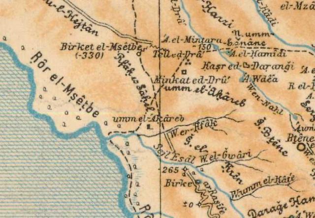
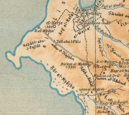
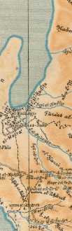
Kallai noted that Mazar had proposed that Hebrew lashon "tongue" might be an allusion to El Lisan "tongue" (in Arabic), a peninsula jutting into the Dead Sea and perhaps the Ascent of Akrabbim was the ascent from the southern plain of Lisan to the height or elevation called Umm el 'Akareb via a track at a site called Umm el Akareb, cf. the below map for these two Akarebs (Alois Musil. Karte von Arabia Petraea. circa 1907, Vienna, Austria 1:300,000). If Mazar is correct then Israel's border was at the east side of the Dead Sea rather than the West side.
Kallai:
"...from the bay (lashon)...'uttermost part of the Salt Sea that looked southward'...Numbers 34:3...reads 'from the end of the Salt Sea eastward'...it may be inferred that the border begins at the eastern side of the extremity of the Salt Sea and includes the Arabah to the south of it. Consequently, Mazar is inclined to think that Maaleh-Akrabbim too is in this region, and he perceives a connection between it and `Umm `el-`Aqarib at the south-eastern end of the peninsula above Sel `el-`Asal."
(pp. 116-117. Zecharia Kallai. Historical Geography of the Bible, The Tribal Territories of Israel. Jerusalem & Leiden. The Magness Press. The Hebrew University. E. J. Brill. 1986)
My note: Mazar's Sel `el-`Asal is Musil's (1907) Sejl 'Esal, a stream rendered in blue on the below map. The biblical text suggests that Akrabbim is associated with a toponym called Sela, could Sela be 'Asal/Esal south of the ascent at Umm el-`Aqarib/Akareb? If so, then the "mysterious" Ascent of Akrabbim and its Sela is east of the Dead Sea not west of it, which is why it eluded detection for so long by scholars!
Judges 1:36 RSV
"And the border of the Amorites ran from the ascent of Akrabbim, from Sela and upward."
My note: Hebrew lashon "tongue" if applied to the sea and not to the Lisan Peninsula "might" be describing the small tongue (in blue) above el-Mezra' and east of Ard el-Ketat on the below map, which would allow the border to proceed from a sea's tongue to the Ascent of Akrabbim (Umm el- Akareb/Aqrarib east of Ror el-Msetbe).
If Israel laid claim to the Arabah S of the Dead Sea to the Red Sea (Gulf of Aqaba) and if Umm el Akareb is the Ascent of Akrabbim, might Mount Halak, pronouncied in Hebrew as Chalaq/Khawlaq be Jebel el Qulei'a by Petra and Jebel Harun (the mount of Aaron, Hor ha Har, Mt. Hor)? Click here for Halak possibly being Qulei'a. Kadesh-barnea would be Wadi Musa at Petra.
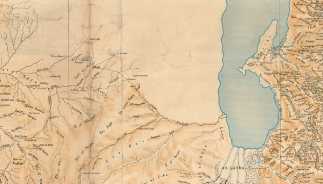
Below a map suggests two fords (?) from Palestine to El Lisan: the northern ford from Wadi Senia (the spelling is not clear?) and the southern ford from Wadi Hatrura. The southern ford in nearest to Wadi el-Asal where Umm el Akareb is located on the noth side of the wadi. Did Israel's border cross the Dead Sea from the vicinity of Wadi Asal (biblical Sela?) and Umm el Akareb (Acrabbim?) to Hatrura? The biblical text suggests that Sodom and Gomorroh were in the plain which is now the south bay of the Dead Sea (Alexander Keith Johnston. Edinburgh. Palestine. 1861)