Mount Halak Map
Walter Reinhold Warttig Mattfeld y de la Torre, M.A. Ed.
Please click here for this website's most important article, "Why a _naked_ Adam in Eden ?
01 July 2004
In the Hebrew Bible Mount Halak is given as the farthest south conquest achieved by Israel under Joshua :
Joshua 11:16-17 RSV
"So Joshua took all that land, the hill country and all the Negeb and all the land of Goshen and the lowland and the Arabah and the hill country of Israel and its lowland from Mount Halak that rises toward Seir, as far as Baal-gad in the valley of Lebanon below Mount Hermon."
Joshua 12:7 RSV
"And these are the kings of the land whom Joshua and the people of Israel defeated on the west side of Jordan, from Baal-gad in the valley of Lebanon to Mount Halak that rises toward Seir..."
Joshua 11:16-17 TANAKH (Philadelphia. The Jewish Publication Society. 1988)
"Joshua conquered the whole of this region: the hill country [of Judah], the Negeb, the whole land of Goshen, the Shephelah, the Arabah, and the hill country and coastal plain of Israel -[everything] from Mount Halak, which ascends to Seir, all the way to Baal-gad in the valley of the Lebanon at the foot of Mount Hermon."
Joshua 11:16-17 Septuaginta
"And Joshua took all the hill country, and all the land of the Nageb, and all the land of Gosom, and the plain country, and that toward the west, and the mountain of Israel and the low country by the mountain; from the mountain of Chelcha, and that which goes up to Seir, and as far as Balagad, and the plains of Libanus, under mount Aermon;"
Joshua 12:7 Septuaginta
"And these are the kings of the Amorites, whom Joshua and the children of Israel slew beyond Jordan by the sea of Balagad in the plain of Libanus, and as far as the mountain of Chelcha, as men go up to Seir:"
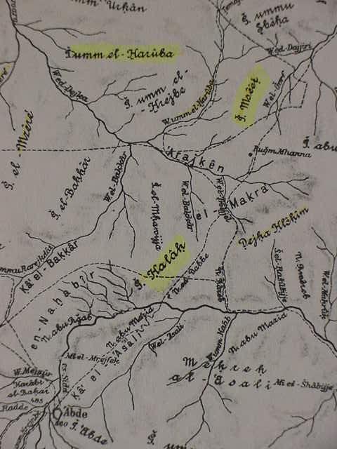
Cohen identifies Mount Halak with Jebel Halaq :
"A mountain mentioned as the south limit of the conquest of Joshua (Josh 11:17; 12:7)...It is described as being "on the way leading up to Seir"...The name and site are preserved in Jebel Halaq on the northwest side of Wadi Marra, north of `Abdeh." (p. 512. Vol. 2. S. Cohen. "Halak, Mount." George Arthur Buttrick. Editor. The Interpreter's Dictionary of the Bible, An Illustrated Encyclopedia. Nashville. Abingdon Press. 1962)
Below, Musil shows Gebel Halak as "G. Halak," (highlighted) bounded on the northwest by Wadi el-Bakkar and Ka el-Bakkar. To the south of Halak is `Abde, Greek: Oboda, a Nabatean site (cf. Alois Musil. Karte von Arabia Petraea. Vienna, Austria. 1908. Scale: 1:300,000)
Please click here for more maps showing Gebel Halak, Kadesh-barnea and the wilderness of Zin.