Wilderness of Paran Map
(by Kadesh Barnea and Zin)
16 March 2004
12 Jan 2006 Update:
As of 04 Jan 2006 I have ABANDONED the notion that Kadesh Barnea is Tell Masos and that the Wilderness of Zin is Khashim Zanna and the Wilderness of Paran is Sahel Farah as portrayed on the below map. For the "new" locations, ENE of Sede Boqer in the Negev please click here for the arguments and maps. I will however "leave" the below map in place (My below "errors" may be of help to others).
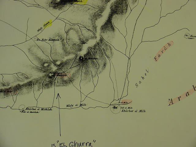
The "wilderness of Paran" near Kadesh Barnea may be Sahel Farah, to the east of Khurbet el Meshash/Biar el Meshash (Israeli: Tel Masos) and Khurbet el Milh/Tell el Milh. I have identified Tel Masos as being Kadesh Barnea because it has the "missing" Iron IA pottery debris (ca. 1220-1150 BCE), and it is also the largest Iron IA site in the Negev, a situation befitting Kadesh-Barnea, where ALL Israel is assembled in view of the Hill Country. I accordingly associate the "wilderness of Zin" (LXX and Latin Vulgate Sena/Senna) with Khashim Zanna, to WSW of Tel Masos, on an elevation overlooking Masos and Milh in the valley below. The arrow points to "el-Ghurra" a site on the spur which descends from the Judaean Hill Country, this spur is called today by the Israelies Hare Ira (For the map below, cf. The Palestine Exploration Fund Map. London 1878. Scale: 1:63,000. Sheet XXV) Note: I make a distinction between the wilderness of Paran in the Sinai at the Feiran Oasis and Wadi Feiran and its headwaters, and "another Paran" near Kadesh Barnea (Tel Masos) and Zin (Khashim Zanna). Could el Ghurrah be Mount Hor, Hebrew Hor-ha-har, where Aaron was buried ?