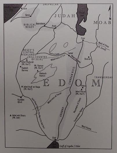
Crew's map showing the "Hill Country of Seir" to be the Central Negev, is based on the notion that Kadesh Barnea, identified by most scholars with Ain el Qudeirat, is near the Hill Country. Please click on the following blue underlined url to read Crew's in-depth arguments and see more clearly his map: "Did Edom's Original Territories Extend West of Wadi Arabah ?"
Note: Bruce R. Crew has a PhD in Geography, and this article is probably based on an earlier article "The Negev as Part of the Territories of Edom." Biblical Geographical Newsletter. 4:2-3. 1984.
I have argued that Seir is in the Hill Country north of Kadesh Barnea, seized by Edom after 586 BCE when Judah went into Exile. I understand that the Primary History, Genesis-Kings was written ca. 560 BCE in the Exile.
Of interest is Crew's identification of the Darb es Sultan "the king's way" extending from Ain Weibeh in the Arabah to the vicinity of Gebel Haluqim (biblical mount Halak ?) near Sede Boqer as being the "kings' highway" Israel wished to use from Kadesh Barnea (Nu 20:16). I have proposed that Kadesh Barnea might be the Iron II Israelite fortress and village of Horvat Haluqim near Sede Boqer and the Darb es Sultan. Please click here for the maps and arguments.
I am also in agreement with Crew in his location of a Mount Seir at Gebel es-Shaira, west of the head of the Qulf of Aqaba, as possibly being "the way of Mt. Seir" (Darb es-Shaira) in Deuteronomy 1:2.