The Gihon River is Wadi al Gineina/Junaynah, Wady Kenous, or Mount Gianadel or Jan-Adel in the Sudan or Nubia (ancient Cush) or El Gianieh of the 1st Cataract east of Philae Island?
(Note: This is a _Major Revision_ of 25 October 2009, deleting all earlier proposals)
Revisions through 13 April 2010
The Nile river has been identified with the Gihon river appearing in Genesis 2:13 since the creation of the Septuaginta, a Greek translation of the Hebrew Bible by Jews for Jews living in Alexandria, Egypt circa the 3rd century B.C. The late 2nd century B.C. Jewish Book of Jubilees also portrayed the Nile as being the Gihon. The first century A.D. Jewish historian Flavius Josephus in his History of the Jews written after 70 A.D., apparently following the Septuaginta and Book of Jubilees also identified the Nile with the Gihon. The early Church Fathers of the Christian Church accepted these Jewish identifications. The Gihon is described as flowing about or through the land of Cush (Ge 2:13) which may have suggested to the 3rd century B.C. Jewish authors of the Septuaginta that Egyptian Cush or Kush (modern-day Sudan) was meant.
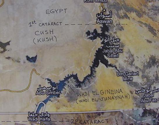
To the degree that Gihon might refer to the Nile "in" Cush, it is worth noting that several maps on the internet appear label a village (?) on the Nile as Wadi el Gineina or Wadi al Junaynah south of Lake Nasser and the Aswan Dam. In antiquity Cush's northern border began at the first cataract of Nile which is near Aswan (Greek Syene). So the village of Wadi Gineina south of Aswan in antiquity apparently lay in Cush. Does Gineina(Junaynah) preserve in Arabic the Gihon which flowed through Cush? Please click here to see Wadi el Gineina on the Nile south of Aswan and Lake Nasser.
Genesis 2:13 RSV
"The name of the second river is Gihon, it is the one which flows around the whole land of Cush."
Most commentators understand that Cush is a reference to the Egyptian Kush (Cush), a land south of ancient Egypt (the modern-day Sudan).
Gihon according to Strong's Hebrew and Chaldee Dictionary (James Strong. Strong's Exhaustive Concordance to the Bible. Waco, Texas. Word Books. 1970): # 1521, Giychown, ghee-khone, or Gichown, ghee-khone from
# 1518 stream; Gichon, a river of Paradise. # 1518, giyach, ghee'-akh, or goach, go'akh, a primitive root to gush forth (as water). If the Nile is the Gihon, could the cataracts of the Nile be what is behind the notion of "gushing water"?
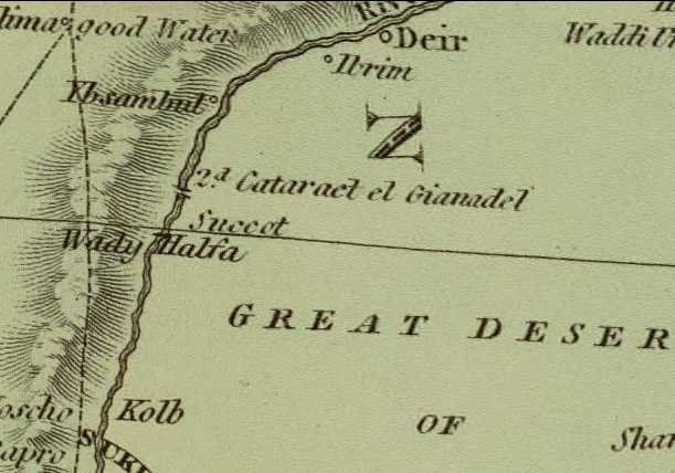
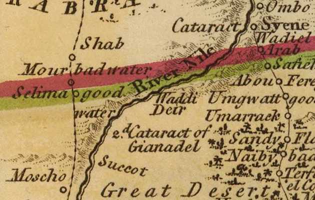
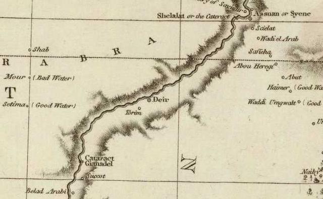
Below, a map made in 1831 showing that the 2d cataract, which would have lain in antiquity in Cush, is called el Gianadel (the cataract is north of Wadi Halfa). Perhaps Gian[adel] preserves in Arabic Hebrew Gihon? To the degree that Strong's Hebrew and Chaldee Dictionary defines Gihon as derived from a root meaning "to gush" as in "water gushing," this is an apt name for the gushing waters of the Nile at the Cushite 2d cataract of el Gianadel. Perhaps Genesis' Gihon river in Cush is then preserved in the regional land area's name of Wady Kenous and the 2d cataract of el Gianadel? (The below map is by Daniel Lizars. 1831. Titled: "Arabia with the Adjacent Countries of Egypt and Nubia." It is available on the internet at the David Rumsey Historical Maps Archive) Please click here to access the interactive version of the below map allowing you to enlarge and scroll N-S, E-W. Note: The Septuaginta Bible written in Greek by Jews for Jews at Alexandria, Egypt circa 275 BC in the reign of Ptolemy II renders Gihon as Geon. Christians used the Septuaginta so it is possible that when Islam conquered Byzantine Christian Egypt in the 7th century AD, the Septuaginta's Greek form, Geon, passed into Arabic possibly as Gian(Gianadel?).
Apparently the Nile as it winds it way north from Africa's Central Lakes District is given different names by the local natives residing along its banks. In Cush, modern Sudan, it may have been (?) called Wady Kenous "River of Kenous" (Wady Gineina/Junayah?) between the 2d and 1st Cushite cataracts, the 1st cataract being ancient Egypt's border with ancient Cush. Today, this region or land area, Wady Kenous, is under the waters of Lake Nasser (called Lake Nubia in the Sudan) formed by the Aswan dam.
The French scholars who compiled a History of Egypt and their findings (1796-1813) under the patronage of the French Emperor Napoleon Bonaparte I observed that the Coptic Boharic recension of the Septuaginta renders Greek Geon as Pi-Keon (p. 45, Description de l'Egypte. Paris. 1813), and that the Jewish scholar Moses of Chorene/Khorene, circa 410-490 AD rendered Gihon as Kehon in his work (p. 45, Description de l'Egypte). "Pi" in Hebrew means "mouth of," perhaps the "mouth of Keon" is the 2d cataract of Gianadel, as type of "mouth" for Wady Kenous?
The prophet Ezekiel located Cush's border with Egypt at Syene (modern Aswan) and the 1st cataract of the Nile:
Ezekiel 29:10
KJV:
"Behold, therefore I am against thee, and against thy rivers, and I will make the land of Egypt utterly waste and desolate, from the tower of Syene even unto the border of Ethiopia.."
NIV:
"...therefore I am against you and against your streams, and I will make the land of Egypt a ruin and a desolate waste from Migdol to Aswan, as far as the border of Cush."
GWT:
"That is why I'm against you and the Nile River. I will turn Egypt into a pile of rubble. It will become a wasteland, from Migdol to Syene, all the way to the border of Sudan."
The 2nd cataract is rendered in older works under different spellings: Jan-Adel, Gianadel, Genadil, Ge-na-dil in texts from the early 1800's written in France (Napoleon Bonoparte I briefly occupying Egypt, 1798-1799).
A description of the 2nd cataract, emphasis mine (2005):
"Despite its name, the second cataract is not a single precipitious fall of water but a series of lesser obstructions in two groups, separated by about 35 kilometers of reasonably clear water. The northern end is marked by a dense group of rocky islands treacherous for navigation, the southern, at Semna, by a narrow rocky barrier through which the river gushes in several torrents. In both cases sailing was hazardous when the river was low, but at full flood the obstacles were sufficiently submerged to allow careful sailors safe passage."
(p. 236. Barry J. Kemp. Ancient Egypt: Anatomy of a Civilization. London. Routledge. 2005)
I note that Kemp speaks of the GUSHING in several torrents of the Second Cataract and Gihon in Hebrew means "TO GUSH": Strong's Hebrew and Chaldee Dictionary # 1518, giyach, ghee'-akh, or goach, go'akh, a primitive root to gush forth (as water).
A description of the 2nd cataract circa 1899:
"The cataracts hinder navigation of the Nile, and have done so for thousands of years. The ancients used the strong north winds to sail up the Nile in Egypt, but this could not carry them over the cataracts. Instead, the boat would have to be dragged up the cataract by teams of men, often with great difficulty...The best description of cataracts comes from 'The River War', written in 1899 by Winston Churchill, then 25 years old. The book details the exploits of the British in 1896 through 1898 to return to the Sudan after they were chased out by the Sudanese people in 1885. The British tried to reconquer the Sudan by steaming in gunboats up the Nile, so they were very interested in how the water flowed through the cataracts. They knew that the only time that ships could move upstream through the cataracts was during the summer flood, and then only with great difficulty. Churchill describes the Second Cataract (now submerged beneath Lake Nasser) as being about 9 miles long and having a total descent of sixty feet. The river flowed over successive ledges of black granite. During the summer floods, the Nile flowed swiftly but with an unbroken surface, but the granite ledges were exposed when the annual flood abated. During this time, Churchill reported that the river tumbled violently from ledge to ledge, its entire surface for miles churned to white foam. There are several other small cataracts between the Second and the Third Cataracts (Churchill shows cataracts near Semna, Ambigol, Tanjore, Okma, and Dal) but none of these posed any problems to the British moving upstream..."
A more "poetical" description (1890) of the 2nd cataract area:
"The cataract – an immense multitude of black and shining islets, among which the river, divided into hundreds of separate channels, spreads far and wide for a distance, it is said, of more than sixteen miles, – foams at our feet. Foams, and frets, and falls; gushing smooth and strong where its course is free; murmuring hoarsely where it is interrupted; now hurrying; now loitering; here eddying in oily circles; there lying in still pools unbroken by a ripple; everywhere full of life, full of voices; everywhere shining to the sun."
(Amelia B. Edwards. "The Second Cataract." A Thousand Miles Up the Nile. 1890)
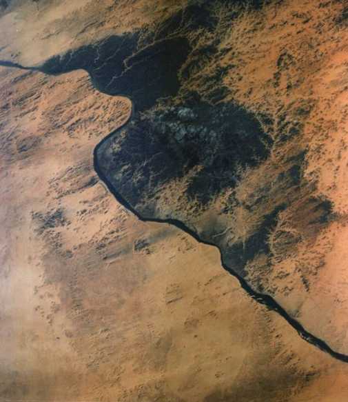
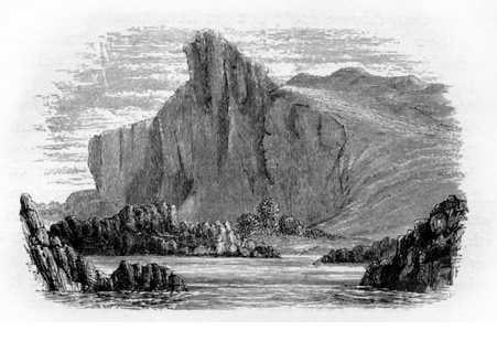
French travelers, 18th/19th century AD, spoke of a mountain (montagne) called Gianadel, and alternately, the "cataract" of Gianadel. An aerial photo shows that the basalt rocks in the 2nd catact are an extension of a basalt area (black color in the photo) lining the bank of the Nile. Today the 2nd cataract is under Lake Nasser formed by the Aswan Dam erected in the 1960s..
Ritter (1835):
"...on lui donnait le nom de Jan-Adel ou Gianadel, mot qui est, chez les Arabes, l'appellation generale pour les cataractes, comme Yellala sur le fleuvre Congo."
(p. 280. Vol. 2. Karl Ritter. Geographie Generale Comparee, ou Etude De La Terre. Paris. 1835)
D'Herbelot (1777):
"...si la cataracte du mont Gianadel ne les empechoit..."
(p. 611. Vol. 1. Mr. D'Herbelot. Bibliotheque Orientale ou Dictionaire Universel. Vol 1, "A-E," J. Neaulme & N. Van Daalen, Libraries. 1777)
Panckoucke (1821):
"Il en est de meme de la cataracte...au dessus d'Ibrim, et on l'appelle Giandel, nom que plusieurs ecrivent Jan-Adel, mais sans fondement: on croit qu'elle est due a une chaine de montagnes qui va de l'est a l'ouest, vers le 22 degrees 15 minutes de latitude...El-Edricy rapporte que les barques de Nubie sont forcees des arrester a la montagne de Gianadel, et que de la les marchandises sont transportees a dos de chameau jusqu'a Syene, qui en est eloignee de douze stations."
(p. 168. Vol. 1. Charles Fleury Panckoucke. Description De l'Egypte. 2nd edition. Paris. 1821)
"Sel on Abou-l-feda "les deux chaines de montagnes qui enferment la haute Egypte partent de Genadil: au dessus d'Asouan, il y a une montagne d'ou le Nil coule et forme une cataracte a travers des rochers aigus el elves, ou les barques ne peuvent passer; c'est la la limite de la navigation des Nubiens, cote du nord, et des Egyptiens, du cote du midi. "Michaelis pense que Genadil est un nom propre egalment donne a la chute de Syene et a celle qui est au-dessus: j'ignore sur quoi il appuie son opinion; mais, si elle etait fondee, elle contribuerait a expliquer comment l'on a confondu l'une et l'autre cataracte. Les geographes Strabon at Ptolemee, ainsi qu Heliodore, Eustathe et d'autres anciens, distinguaisent seulement deux cataractes, la grande et la petite, quoiqu'ils sussent vaguement qu'il y en avait davantage; et leurs descriptions s'appliquent toujours a celles de Genadil et de Syene."
(pp. 169-170. Vol. 1. Panckoucke. 1821)
Panckoucke cites the research of Raige on what Gianadel might mean: "a precipice," (Arabic?) or the "quality of excessiveness" (Persian?):
"Il resulte des recherches que M. Raige a bien voulu faire a ma priere sur ce nom, que l'on ne peut s'en tenir au sens de Genadil, pluriel de gendal, qui signfie pierre suivant Golius, et dont la racine veut dire reverser: il prefere le sens de Ge-na-dil, dont le premier mot signifie en araba eleve, et a la racine, tomber, se precipiter; le second mot est persan, et designe metaphoriquement une qualitie excessive."
(p. 170. Vol. 1. Note 1. Panckoucke. 1821)
Tzschvklo (1806):
"D'Anville p. 216, c.l. exlagto Turcorum se audiisse scribt, hunc esse in Nubia et a monteGianadel effici."
(pp. 260-261. Carlo Henrico Tzschvcklo. Pomponii Melae de Sitv Orbis. Libri Tres (Vol. 3, part 1) Lipsiae (Leipzig?), 1806)
De La Croix (1687):
"On doit savoir que le Nil an sortir de la Nubie renconrre la Montagne de Gianadel, dont les Rochers pointus and escarpez changent la lenteur de son cours: l'enceinte des cataractes est de 50 stades d'etendue; c'est une pente droite, enfermee de rochers and de valees; le Nil passant au milieu and seprecipiant de la pointe de ces roches fait un horrible fracas: tellement que ces cataractes tombent de la hauter de 200 pies non en droite ligne, mais obliquement..."
(p. 351. Vol. 1. A Pherotee de la Croix. Relation Universelle de l'Afrique, Ancienne et Moderne. Lyon. 1687)
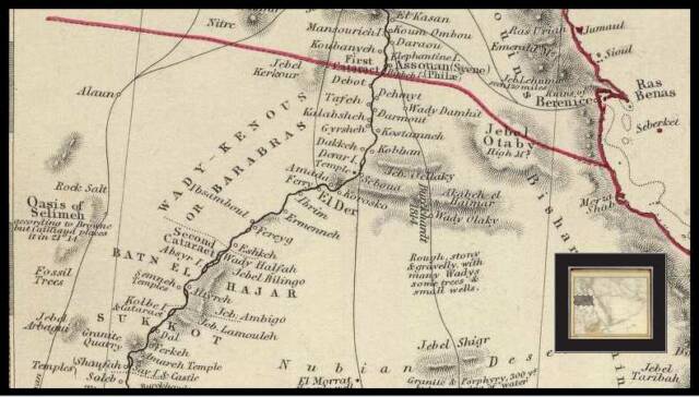
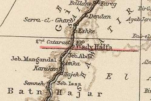
Below, a map of the second cataract (1814, John Pinkerton. Pinkerton's Modern Atlas. London) showing a JebelMangandal on the west side of the Nile, south of Wady Halfa, perhaps this is the "Montagne Genadil" of French texts (1687, 1821) cited from above? That is to say the Man- of Mangandal was _in error_, rendered into French as Montagne (Mountain)? Its "correct" rendering is Mangandal not Montagne Genadil?
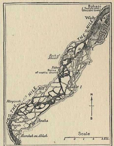
Below, I have added in ink, the location of the 1st and 2nd Cataracts of the Nile near Aswan and Wadi Halfa, noting the location of the village of Wadi el Gineina, alternately Wady al Junaynah. The Second cataract is called el Gianadal according to Lizars 1831 map, above (note: a number of villages on the Nile bear the name Wadi, as in Wadi/Wady Halfa near the 2nd Cataract)
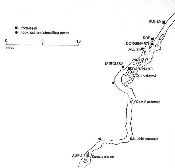
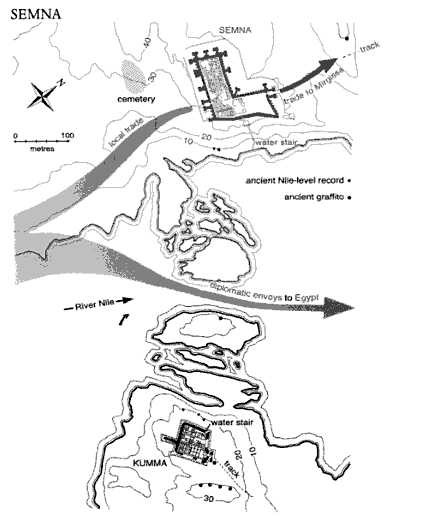
Below, a map showing ancient Middle Kingdom Egyptian forts controlling the area south of the Second Cataract:
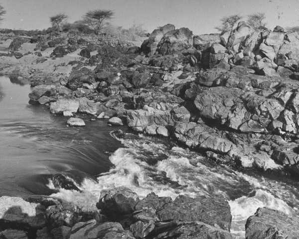
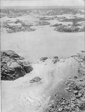
Below, a photo of "white water" at the Second Cataract circa 1954:
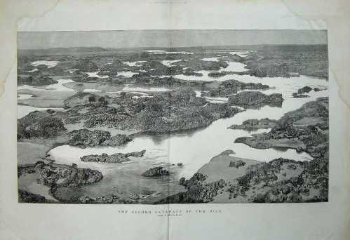
Below, a panorama of some of the basaltic rocks with silt sediments in the Second Cataract (1880's), French texts describe the Gianadel as the "Grande Cataract" in contrast to all other cataracts:
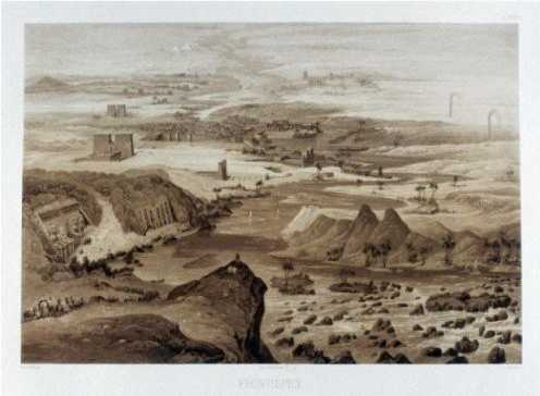
Below, an artist's "imaginative" somewhat "romanticised" sketch (1841) of a panoramic view of the Nile from the Second Cataract's rapids to the Mediterranean Sea, "mountains" are shown on either side of the Nile at the Second Cataract:
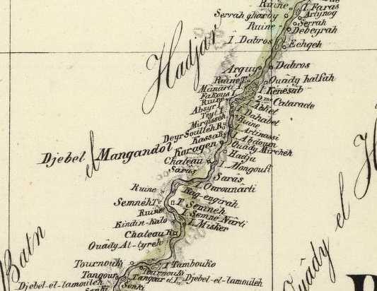
The below map is a "highly detailed" drawing of the islands and rocks found in the second cataract region (from Gaston Maspero's History of Egypt, Chaldea, Syria, Babylonia, and Assyria by Grollier Publishers, London, 1906, 13 volumes), the town of Wady Halfa being in the upper right corner. Note that the 1831 map (cf. above) places the 2nd cataract called Gianadel _north_ of Wadi Halfa. Could the island of Kenesab S. of Wady Halfa preserve Ken, Kens, Gi'chon?
Below: an aerial photo showing the basaltic rock formation lining the Nile which contributes the basaltic rocks and boulders found in the Second Cataract region (the blackened area is pretty much "the length" of the Second Cataract region), reckoned by some as either 9 miles (Churchill, 1899) or 16 miles (Edwards, 1890). Is this black basaltic (granite) region "the Mountain" of Gianadel or Jan-Del of texts of the 17th-19th centuries AD? If so, and "if" the Gihon is Gianadel/Jan-del, then "the river _of_ Gihon" may have taken (?) its name from this granite mountain through which the Nile cut its channel. Note how it "winds about" (twists and turns) or "encompasses" the land of Cush as described in the Bible:
"The name of the second river is Gihon; it is the one which flows around the whole land of Cush."
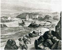
Below, the British Army, November 1884, using tow ropes, pulling boats up the Nile through the Second Cataract's rapids
(a wind blowing from north to south allows Arab sailboats to sail up the Nile, against its current, as far as the Second Cataract, their sails are in the distance in this picture.
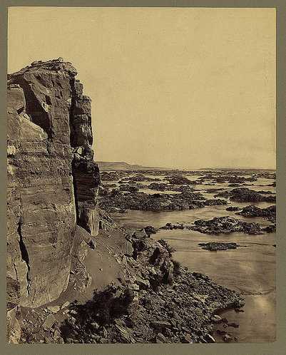
Below, the crag of Abou Seer (Abusir) overlooking the Second Cataract area.
Below, a sketch of Abusir (?), a crag towering over the Second Cataract area, a favorite spot for tourists to get a panoramic view of the Second Cataract and its rapids:
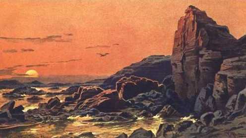
Below, a romanticised rendering of the crag of Abusir (?) overlooking the Second Cataract.
Below, "white water" descending or "falling" at the Second Cataract.
In 1843 El Gianieh (1798/1828 maps) was described as a "Nubian village" (German: nubische dorfchen) near the palm tree covered island of Philae:
"Zwischen diesen Bergen ist der Nil eingezwangt, ein dunkler Spiegel, wie unser Alpensee'n. Links sahen wir den Minaret de Moschee von Anbea, rechts das nubische Dorfchen el Gianieh und zwischen beiden eine Insel mit Palmen, uber deren Gipfel hoch empor die Pylonen der Tempel ragten, umgeben von Saulen und Trummern. Es ist Philae, die Zaubeinsel."
(p. 196. Joseph Russegger. Reisen in Europa, Asien und Africa... Zweiter Band (Volume Two): Reisen in Egypten, Nubien und Ost Sudan. Stuttgart. E. Schweizerbart'sche Verlagshandlung. 1843)
For those who don't read German, a rough translation or paraphrasing:
This is a German Travel Guide and apparently the author (the Guide) is on the east side of the Nile facing west. On his left (links) is the Mosque of Anbea with tombs, to his right (rechts) is the Nubian (Nubians are Cushites) village of El Gianieh, between these two locations, in the midst of the Nile, lies the palm tree laden island of Philae with its ruins; he briefly describes the Ptolemaic Era Philae temple's architectural features mentioning its pylons. He metaphorically describes the Nile here as between mountains, the scene recalling for him an Alpine lake (see) in the Alps mountains, its water like a dark reflecting mirror.
Conclusions (01 April 2010)
This "work in progress" (06 Jan. 2007 to 01 April 2010) has attempted to find the presence of a word associated with the Nile in Cush that "might" preserve the Hebrew Gihon (Greek Septuaginta: Geon).
Several proposals have been made:
(1) As Cush was called Ta Kens, Wadi Kenous might preserve the name (map of 1843); the Coptic Boharic recension of the Septuagint: Pi-Keon, and Moses of Chorene: Kehon.
(2) The 2d cataract of the Nile being called Gianadel might preserve Gihon (maps of 1812 and 1831).
(3) The village of El Gianieh on the south side of the 1st Cataract might preserve Geon/Gihon (map of 1828, survey 1798)
I now (as 27 March 2010) favor number (3) because the prophet Ezekiel speaks of Egypt as extending from Migdol to Syene (Ez 29:10; 30:6). Syene is near the 1st Cataract of the Nile so Cush's border would be south of Syene (modern Aswan). To the south of Syene on the above maps is El Gianieh and the island of Philae. As El Gianieh is somewhat at the beginning of the 1st Cataract it may have lent its name as the "river of Gianieh" which in Hebrew became the Gihon/Geon River? That is to say the village of Syene lies at the north end of the 1st Cataract whereas the village of El Gianieh lies at the south end of the 1st Cataract, apparently in Cush (?), as Syene at the north end of the 1st Cataract is Egypt's border according to Ezekiel.
Flavius Josephus a Jewish historian of the 1st century AD identified the Gihon with the Nile in Cush. He said Gihon meant "that which rises in the east." The Nile does possess an eastern tributary the Atbara ultimately draining via its tributaries from the mountains of modern Ethiopia near Lake Tana. Perhaps, as the Garden of Eden was described as being "in the east" the Nile was conceived as originating "in the east" at Eden (via its eastern tributary)?
Josephus also described the river of Eden "as running about the earth and subdividing into four streams," the Pishon (Ganges of India), Gihon of Ethiopia (Cush/Sudan) and the Tigris and Euphrates, apparently he is refering to Greco-Roman geographers' notions of his day.
Homeric Greek myths (9th-8th centuries BC) had _all_ rivers arising from _one_ great freshwater stream which ran all over the earth called River Okeanos. All rivers via underground streams linked to Okeanus (Ocean). As late as the 1st century BC some Greco-Roman geographers thought that the Euphrates lost itself in marshes in southern Mesopotamia and re-emerged in Ethiopia as the Nile. In the 4th century BC the Greeks thought the Indus river flowed into the Ethiopian Nile. So ancient Geographers (Greeks) mistakenly thought from Homeric times one river (Okeanos) was source of all the great rivers of the world.
Archaeologists have confirmed Greek pottery in Judea of the 8th-6th centuries BC and Greeks residing in the area (at Arad in the Negeb). Perhaps via these Greek merchants and mercenaries the pre-exilic Jews of the 8th-6th centuries BC came to understand the River of Eden (assimilated to River Okeanus) had subdivided in to a Gihon in Cush/Ethiopia (Sudan) and Pishon of Havilah (Wadi Baish/Baysh of Khaulan of Asir in Saudi Arabia near the Yemen). Please click here for maps of the Baish and Bishah conflated into the Pishon. I understand Genesis-2 Kings was composed circa 562-560 BC in the Babylonian Exile and preserves pre-exilic (9th-6th century BC) Greek notions in Genesis' Table of Nations and description of Eden's four rivers. Please click here for details. Greek mercenaries served in Egypt, Cush, Judaea, and Babylon in the pre-exilic period and may be the source of some of Genesis' imagery about Eden's four streams.
Pharaoh Necho hauled off into Egyptian captivity the Jewish king Jeho'ahaz (609 BC), son of Josiah (2 Ki 23:33-34). By 587 BC Jerusalem had fallen to Nebuchadrezzar and a few years later Gedaliah was slain and Jews with Jeremiah fled to Egypt to avoid reprisals from the Babylonians. Jewish mercenaries at the island of Yeb (Elephantine) near Syene and the 1st cataract may have settled there as early as 650 BC. So Jews in Egypt, would know of the gushing waters of the 1st and 2nd cataracts from first hand knowledge and pass this info on via letters to Jews in the Babylonian Exile, the Gihon River becoming a part of the Primary History (Genesis-2 Kings) of 562-560 BC.
The presence of the word Hebrew word gihon ("to gush") near the 1st and 2d cataracts might be due to Jewish mercenaries at Yeb since 650 BCE, or possibly via Byzantine Christians (4th-7th century AD) who, using the Greek form Geon from the Septuagint bible caused the name to be fixed in the area, the Arab conquest of the 7th century AD may have rendered the Byzantine Christian Geon into Arabic El Gianieh and Gianadel (localities in the vicinity of the 1st and 2d cataracts).
I am _unaware_ of any scholar other than myself proposing that the Gihon/Geon River of Cush (associated with Genesis' Garden of Eden) might have its name preserved at either the 2nd Cataract of Gianadel or 1st Cataract at the Nubian village of El Gianieh.
If Strong's Exhaustive Bible Concordance (Hebrew and Chaldee Dictionary) is correct in suggesting Hebrew gihon means "to gush" as in water gushing, perhaps Gihon meant the "Gushing River," so named after the Nile's most distinguishing and prominent feature in the land of Cush (Sudan), its many cataracts and their gushing waters? Josephus said Gihon meant that which _rises_ in the east. The Cushite Nile's rising waters each year causes not only gushing at the cataracts the river's "rising" also caused the annual flooding of the Egyptian Delta. So both both terms are appropriate in describing the Cushite Nile: "rising" and "gushing." Does Gihon mean "the Rising River" or the "Gushing River," or "both"?
Perhaps it means the "Rising River" as Egyptian texts have the god Khnum declaring he is the Nile in its _rising_, a notion supporting somewhat Josephus' statement about Gihon meaning "that which rises in the east":
The Egyptian Pharaoh Zoser in an inscription found near Aswan is portrayed as stating that he prayed to the god Khnum to end a 7 year famine in Egypt. Khnum answered his prayer by causing the Nile to rise and flood its banks:
"...Khnemu appeared before him, and said, I am Khnemu the creator...I am he who created himself. I am the primeval watery abyss, and I am the Nilewho riseth at his will..." (p. 53. Vol. 2. E. A. Wallis Budge. The Gods of the Egyptians. New York. Dover Publications.[1904], reprint 1969)
Some have noted an underground subterranean spring in a cavern at Jerusalem called the Gihon. Egyptian art shows two Niles rising forth from a subterranean "double cavern" called Qerti on the island of Elephantine (Egyptian Abu or Yeb). As the Jerusalem Gihon spring rises/gushes forth from a subteranean source in a cavern perhaps the connection might have been made via the Egyptian myths about a subterranean source for the Egyptian Nile with the Jerusalem Gihon spring? Jewish mercenaries did live on Elephantine before Egypt's 525 BC conquest by Cambyses of Persia and being aware that the local Egyptians believed that the rising of the Nile was from the Qerti cavern they may have equated this cavern's spring with their subterranean Gihon spring at Jerusalem?
Please click here for a picture of the the Two Niles which flowed through Egypt, Hap-Reset (South Nile) and Hap-Meht (North Nile) rising from their mythical subterranean source, the Qerti or "Double Cavern" on the island of Elephantine near the 1st Cataract.
Emery (1967) noted that Cush was commonly called Ta Kens, Budge (1904) understands that Egypt's first nome Kenset was the region of the 1st Cataract (does Kenset preserve Kens?):
"It is important to note that Hep [Hapi] is mentioned in connection with Kenset...the first nome of Egypt, in which were included the First Cataract and its islands Elephantine, Sahel, Philae, Senmut, etc., and thus it would seem as if the Nile-god Hep, and Ap-uat, "the opener of the ways," were....connected with places in which in later times the Nile was thought to rise...The Egyptians believed that the Nile rose in the First Cataract, in the Qerti or "Double Cavern..."
(pp. 42-43. Vol. 2. "The Nile God." E. A. Wallis Budge. The Gods of the Egyptians. New York. Dover Publications. 1969 reprint of 1904 Methuen & Company, London)
The Coptic Boharic recension of the Septuagint renders Geon as Pi-keon, perhaps Pi recalls Hapi (?) and Keon recalls Khnem (?); does Wady Kenous the region between the 1st and 2d cataracts preserve the Egyptian Ta Kens, "Land of the Bow"?
As can be seen there is much confusion here. Part of the confusion is that Egypt's border with Cush varied over time. At first it was at the 1st cataract, later the border shifted further south to the 2d cataract. The Bible suggests Cush's border is at the 1st cataract as Ezekiel describes Egypt's southern border at the fortress of Syene, modern Aswan.
Egyptian texts state the Nile rose from the depths of a cavern spring on the island of Elephantine near Syene/Aswan and the 1st Cataract. Jerusalem's Gihon spring rose from a subterranean source too. Jews on Elephantine circa 650-562 BC could have equated this subteranean spring source of the Nile on Cush's border with the Jerusalem Gihon spring.
The Septuagint's Geon could have been applied to the Cushite Nile in Byzantine Christian times being preserved later in Arabic as Gianieh near the 1st cataract or Gianadel at the 2d cataract.
All of the above associations "may be a part" of the big picture behind as to why the Nile in Cush came to be called Gihon recalling for Jews at Elephantine similar phenomena at Jerusalem's Gihon spring.
Gihon according to Strong's "Hebrew and Chaldee Dictionary" (James Strong. Strong's Exhaustive Concordance, Complete and Unabridged. Waco, Texas. Word Books.1977 edition):
1518. giyach, ghee'-akh or
goach, go'-akh;
a primitive root, to gush forth (as water), gen. to issue:- break forth, labor to bring forth, come forth, draw up, take
out.
1519. giyach (Chaldean), ghee'-akh or
guwach (Chaldean), goo'-akh; corresponding to 1518, to rush forth: -strive.
1520. Giyach, ghee'-akh, from 1518, a fountain; Giach, a place in Palestine: Giah.
1521. Giychown, ghee-khone'; or
Gichown, ghee-khone' from 1518, stream; Gichon, a river of Paradise; also a valley (or pool) near Jerusalem:-
Gihon.
I note at the 1st cataract a Wad Kouq S of Elephantine island and NW of the village of El Gianieh, could Kouq preserve Strong's alternate rendering of Guwach,goo'-akh?
The French scholars who compiled a history of Egypt and their findings under the patronage of Napoleon Bonaparte observed that the Coptic Boharic recension of the Septuagint renders Greek Geon as Pi-Keon (p. 45, Description de l'Egypte. Paris. 1813), and that Moses of Chorene rendered Gihon as Kehon in his work (p. 45, Description de l'Egypte).
Egyptian texts suggest the Nile could be called Khnum:
"...But if the prayers of men are granted when he rises, and if he makes himself to be called Khnum for them, when he goes up, then the earth shouts for joy, every belly makes glad..." (p. 31, Alexandre Moret. The Nile And Egyptian Civilization. London. Routledge & Kegan Paul. [1927], reprint 1972)
The Egyptian Pharaoh Zoser in an inscription found near Aswan, is portrayed as stating that he prayed to the god Khnum to end a 7 year famine in Egypt. Khnum answered his prayer by causing the Nile to rise and flood its banks.
"...Khnemu appeared before him, and said, I am Khnemu the creator...I am he who created himself. I am the primeval watery abyss, and I am the Nile who riseth at his will..." (p. 53, Vol. 2, E. A. Wallis Budge. The Gods of the Egyptians. New York. Dover Publications.[1904], reprint 1969)
Septuagint, LXX (3rd century BC):
"And the name of the second river is Geon, this it is which encircles the whole land of Ethiopia."
According to some scholars the ancient Egyptians called ancient Nubia Ta-kens, meaning "the Bend Land" or the "Land of the Bow." There are two great "bends" in the Nile between Meroe and Buhen (the 2nd cataract). Professor Emery suggests that _the region of Cush or Kush was associated most specifically with the land south of the 2d Cataract of the Nile_ and I have noted (above) this cataract's name in 1831 was apparently (?) Gianadel, perhaps preserving the Christian Septuaginta Bible's Geon (Gihon).
Professor Emery (1967):
"Even the origin of the name Nubia is obscure. Strabo, quoting Eratosthenes, writes: "On the left of the course of the Nile live Nubae in Libya, a populous nation. They begin from Meroe, and extend as far as the bends [of the river]...Among the many names by which the ancient Egyptians referred to Nubia the most commonly used was
Ta-kens, "The Bend Land" or the "Land of the Bow." But this was only a general term, and they distinguished between Lower and Upper Nubia by calling the northern area, between the first and second cataracts, Wawat, and the second cataract, Kush."
(p. 4, Walter B. Emery. Lost Land Emerging. New York. Charles Scribner and Son. 1967)
Note: The Bible suggests Syene, modern Aswan, is the border of Egypt and Cush/Ethiopia (Ezekiel 29:10, 30:6), but Professor Emery relates that for the ancient Egyptians the area between the 1st cataract and 2d cataract was called Wawat while Kush/Cush was reserved for the area south of the 2d cataract (the 2d cataract apparently forming the northern border of Kush/Cush). If Emery is correct then perhaps the "mountagne de Gianadel" is the black basaltic region on the east side of the Nile south of the 2d cataract? So the Gihon/Geon river may take its name after this mountain which creates its cataract area.
I note that the Nile does actually form two great bends, could these bends of the Nile account for the land being called Ta-kens? Did the Egyptians call the Nile "Kens" alluding to its great bends in Cush? These two great bows or bends are south of the 2d cataract called Gianadel, the northern border of Kush according to Emery.
The Jewish Publication Society understands the Gihon as "winding" through Cush:
"The name of the second river is Gihon, the one that winds through the whole land of Cush."
(Genesis 2:13, TANAKH, The Holy Scriptures. Philadelphia. The Jewish Publication Society. 1988).
****************************************** 27 March 2010 Special Update ******************************************************
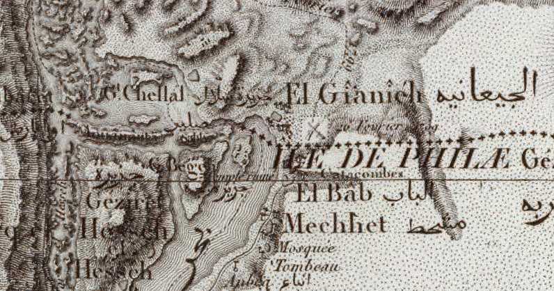
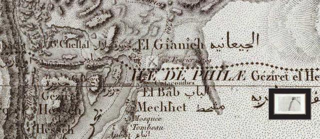
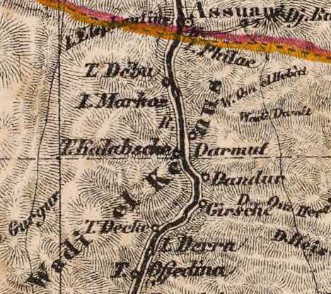
Today, 27 March 2010 at 7 pm Eastern Standard Time (Here in Massachusetts) I found what _may be_ "the source" of the Gihon river's name, it might possibly be preserved in the small village on the east bank of the Nile and the 1st Cataract called on the below French Map of 1828 called El Gianieh.
El Gianieh village has several palm trees about it (near the E of El Gianieh). The island of Philae lies just WSW of
El Gianieh. As Aswan or Syene was regarded Egypt's original border with Cush perhaps the cataract region south of Syene/Aswan was regarded as being Cush? If this be so then El Gianieh lay in Cush and either gave its name to the Gihon River or it may preserve the name (Gihon being rendered as Geon in the Greek Septuaginta Bible of the 3rd century BC which was composed at Alexandria Egypt)?
The below map (1:100,000 scale) is available at the David Rumsey Historical Maps Archive on the internet. Apparently the survey of this area was done under Napoleoan Bonoparte I when he occupied Egypt circa 1796-1798, but published later in Paris circa 1828 by C. L. F. Pankoucke. The map's title is: Carte topographique de l'Egypte et de plusieurs parties des pays limitrophes...Flle 1 ere. les Cataractes, Syene." Please click hereto access this map. Move your cursor over the map to make appear a scrolling bar with plus and minus to magnify or reduce the map image. You can move across this map east-west north-south with by pulling the map with your mouse cursor. The 1st Cataract region is at the top of the map.
The island of Philae appears in French as ILE DE PHILAE. "temple ruine" describes the temple on Philae island.
El Gianieh, which "might" preserve the Hebrew Gihon (Septuaginta Bible: Geon) is on the east bank of the Nile at the beginning of the islands in the cataract area (Chellal means cataract). El Bab is south of Gianieh. El Bab means
"the gate" or "the entrance" perhaps an allusion to this cataract being "the entry point" to Egypt from Cush? South of El Bab is Anbea with its Mosque and tombs which are described in an 1843 German travel guide, cf. below.
The below map made in 1843 reveals that a land region of the Nile between the 2d and 1st cataracts is called Wady Kenous, is this preserved in the village of Wady Ghinah/Junaynah? If so, then the Nile south of Egypt's border, which was the 1st cataract at Aswan, was, in Cush called Gihon between the 2d and 1st cataracts which are waterfalls on the Nile (the below map can be accessed at David Rumsey's Historical Map Collection which is on the internet. Map title: "Arabia, Egypt, Nubia, Abyssinia." Title of the Atlas: Maps for the Society for the Diffusion of Useful Knowledge. London. Volume One. 1844)
Below a map published in 1812 showing the name of the 2nd Cataract to be Gianadel (William Darton Jr. Arabia. Holborn Hill, London. 1812. Book titled: 38 Maps, Union Atlas... This map is available at the David Rumsey Map Collection Archive on the internet)
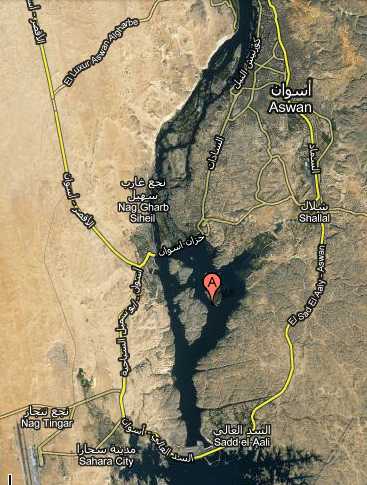
Below a satelitte map (2009) of Philae island (Red dot with "A"). On the east bank of the Nile ENE of this island is the Nubian/Cushite village of El Gianieh. The islands of the 1st Cataract region (Syene/Aswan to El Gianieh) are clearly visible in the satellite view. The modern Aswan Dam appears just to the west of Sadd el-Aali at the bottom of the below map.
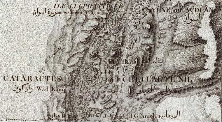
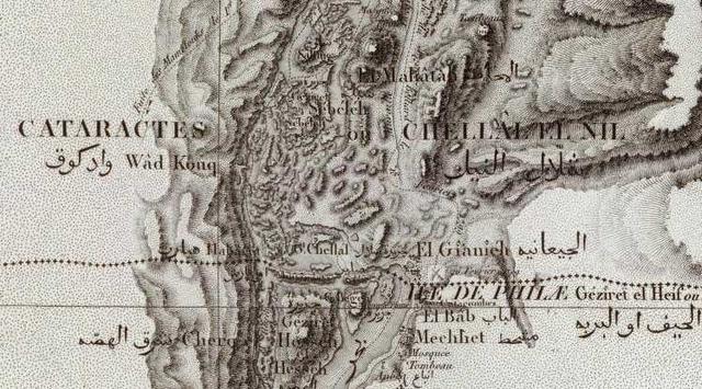
Below a map showing Wady el Kenus (other maps' Kenous/Qenus) as the region about the Nile south of the 1st cataract (1855. Heinrich Berghaus. Leipzig. Egypt, Sudan, Nord Afrika). The Egyptians called Cush Ta Kens and their 1st nome at the 1st cataract was called Kenset. Was the Cushite Nile called Ken or Kens? Does the Hebrew pronounciation gee-khon (English: Gihon) preserve Wadi el Kenus? In other words Wadi el Kenus might be the Arabic equivalent of the River Gihon?
Below a map showing ancient Egyptian forts in the vicinity of the 2d cataract.
Below a map of 1814 showing the 2nd cataract to be called Gianadel (John Pinkerton. Pinkerton's Modern Atlas. London. "Abyssinia and Nubia")
Below a map of 1827 showing Djebel Mangandol south of Wady Halfa (Ouady halfah) and the 2d cataract, perhaps Mangandol is "Montagne Genadil" of French texts (1687, 1821)? (Philippe Vandermaelen. Bruxelles. Nubie & Afrique). Could the island of Kenesab preserve Ken, Kens, Gi'chon (N. of the 2d Cataract)?