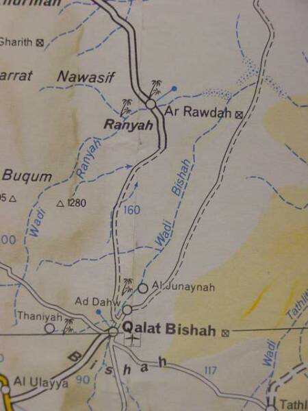
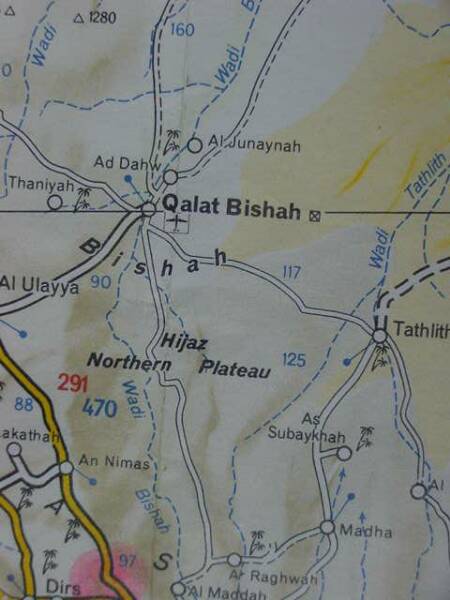
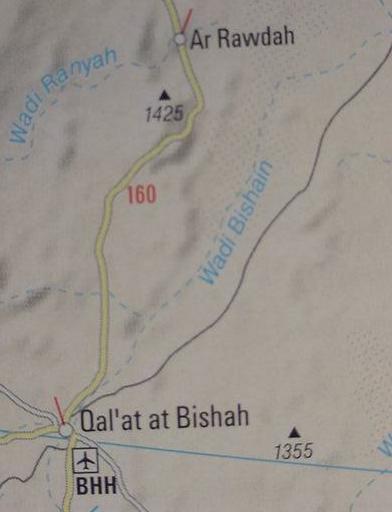
Wadi Bishah is some 300 miles in length and it begins in the coastal mountains of Asir, the headwaters beginning near Khamis Mushayt east of Abha and draining northwards to Qal'at Bishah (cf. the below map for these two locations), emptying into the desert sands of the Nafud Ad Dahy to the ENE of Qal'at Bishah. Sayce's Tihamah Khaulan in Asir lies south of Abha near which are the headwaters of Wadi Bishah. If Bishah is the Pishon River, then the FOUR Khaualan Tribal Areas all lie to the south of the Bishah. In other words to get to the Khaulans, Wadi Bishah must first be crossed, perhaps this is why the Pishon encircles the land of Havilah in Genesis? The Bible takes note of another great river that served as a border to a region (Judah), the "river of Egypt" a wadi like Bishah, today called Wadi el Arish in the midst of the Sinai peninsula. The Septuaginta Bible written in Greek at Alexandria, Egypt in the 3rd century BC by Jews for Jews identified the Nile with the Gihon that flows through Cush (Ethiopia of the Septuaginta). Like the Bishah, the Nile drains "northward" too.
As regards the possibility of Wadi Bishah (conflated with Wadi Baish/Baysh) being the Pishon river (Pison river in the King James Version of the Bible), and Arabic "b" possibly preserving "p", cf. the late professor Yohanan Aharoni's remarks on "p" becoming "b" in Arabic and the loss of the Hebrew sufformative "-on" (Beth-Horon losing its "-on" sufformative to become Beit Ur in Arabic):
"Pe (unaspirated p) when coming by the gradual process, appears in Arabic as fa (ph), e.g. (Beth-)tappuah -Taffuh, Sippori (Sepphoris) -Saffuriyeh. In the immediate borrowing pe becomes beit (b) in Arabic, e.g. Mizphah -Tell en-Nasbeh, Pharpar -Barbar. By the same token Greek pi in Hellenistic names always becomes Arabic beit. This is not a matter of rapid or gradual transmission but rather a straight phonetic shift in the transcription of non-Semitic words, e.g. Tripolis -Tarabulus, Neapolis -Nablus, Paneas -Baniyas...Sufformatives were not permanent elements of the name, that is to say, many names were formed by the addition of sufformatives which can be changed without altering the geographic meaning of the term, e.g. Geba, Gibeah, Gibeon...Thus the sufformatives are usually changed in the Arabic form...a few examples: Almon, Almeth -Khirbet 'Almit; Shaalbon, Shaalabbin, Shaalbim -Selbit; Dothan, Dothain -Tell Dothan; Shiloh (Shilon) -Seilun...(Beth-)nimrah (the waters of) Nimrim -Wadi en-Numeirah. Sometimes the sufformative disappears entirely, e.g. Chesulloth -Iksal; Beth-horon -Beit 'Ur."
(p. 120. "The Study of Toponymy." Yohanan Aharoni. The Land of the Bible, A Historical Geography. Philadelphia, Pennsylvania. The Westminster Press. 1962 (Hebrew text); English texts: 1967, 1979)
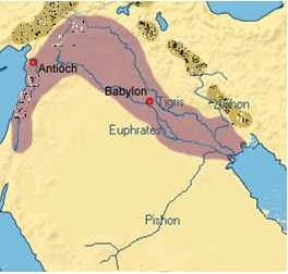
How does a "dry" wadi in SW Arabia "link" to Eden's river, the progenitor of three other streams, the Gihon (Nile) of Cush (Sudan) and Hiddekel (Tigris) and Euphrates of Mesopotamia? The answer will surprise you. In Mesopotamian myths the Sumerian god called Enki (Akkadian Ea meaning "house of water" according to some scholars) lived at Eridu in Lower Mesopotamia (Sumer) and it was he who filled the Tigris and Euphrates with clear sparkling water in the form of "sperm" from his penis! He is THE ONE SOURCE OF the Tigris and Euphrates rivers in Mesopotamian myths. On cylinder seals Enki is shown with two streams erupting from his shoulders suggesting his body as Ea, "the house of water," is the ONE source of the waters for the Tigris and Euphrates. He dwells in the midst of a freshwater stream called the apsu or abzu that "in the beginning," before any land existed, erupted to the surface of the briny sea and the "first land" gathered about this freshwater stream and Eridu was built by Enki. He is the god all the kings and princes of Sumer seek out to provide their cities with freshwater via various wells, springs and rivers. Enki (and his subterranean apsu abode) is THE ONE SOURCE of all the world's rivers, springs and wells. Ipso facto I understand that he is the "one source" of the Nile and and Wadi Bishah as well as the Tigris and Euphrates. Please click here for more details.
The Homeric Greeks believed that a freshwater RIVER OCEAN encircled the world and it was in the midst of the briny sea. From this mythical freshwater stream subterranean rivers flowed which emerged in various parts of the world as rivers. So the Homeric Greeks, somewhat similarly to the Mesopotamians had a mythcal SINGLE STREAM as the source of all the world's rivers via subterranean streams or channels. Greek mercenaries served in Judah under the Saitic pharaohs who slew King Josiah and hauled off his successor Jeho'ahaz in chains to Egypt, appointing in his place Jehoi'akim. Perhaps via Greek mercenaries the Jews learned of a Freshwater stream called River Ocean the source of all rivers via subterranean channels?
Smith (1898) on Josephus' (A 1st century AD Jewish historian) notion the Edenic stream is River Ocean:
"That the ocean stream which surrounded the earth was the source from which the four rivers flowed was the opinion of Josephus." '
(p. 220. "Eden." William Smith. Editor. A Dictionary of the Bible. Hartford, Connecticut. S. S. Scranton & Co. 1898)
So, via either Mesopotamian notions of a single freshwater apsu stream at Eridu or Homeric River Ocean the 7th/6th century BC Jews could in good conscience portray a single river as the source of rivers appearing in Cush (Sudan), SW Arabia and Mesopotamia. Egyptian myth claimed the Nile emerged from the underworld from two caverns or spring holes near Aswan (the Nile's first cataract as one goes "upstream" from the Egyptian delta). Please click here for a picture of the god of the Nile Hapi within a subterranean cavern, holding two vases from which pour the waters of the subterranean Nile. Please click here for pictures of the Nile as a great circle flowing in heaven as well as "under" and "atop" of the earth. The Egyptian sun-god Ra rode in a solar bark or boat on the heavenly Nile and at night he rode in this bark, the Nile of the underworld.
Some, but not all, scholars have sought the Pishon and its land of Havilah as being somewhere near Mesopotamia, or the mountains of Armenia as the Euphrates and Tigris (biblical Hiddekel) flow through these regions. They apparently are unaware that in Mesopotamian, Egyptian and Homeric Greek myths (8th-6th century BC) of a single stream whose many channels, flowing under ground, could give birth to rivers all over the world. Because these scholars could not find a stream on the earth's surface linking any stream in SW Arabia or the Nile in Cush (Sudan) with the Tigris and Euphrates they dismissed as "nonsense" the clues preserved in the Septuaginta that Cush was Ethiopia, and they dismissed Genesis' statements about Havilah being a son of Joktan and brother of Sheba and Hazarmaveth (Hadramawt) who in Arabic traditions are assoicated with SW Arabia.
Muller on the Pishon being possibly a conflation of wadies Bishah and Baish/Baysh (emphasis mine):
"Pishon. The first of the four rivers into which the stream that springs from the Garden of Eden is divided (Gen 2:11). The Pishon surrounds the land of Havilah, where there is gold. Several proposals have been made to identify this country and its river. If, however, Havilah is to be equated with the large and old tribal federation of Khaulan in SW Arabia, the Pishon likewise is to be localized in that region...A. Springer (1875:49) was the first who compared the biblical Pishon with the Wadi Baish in the SW of the Arabian peninsula. Al-Hamadi (1884:73) nevertheless writes that the Wadi Baish is fed from tributaries from the north of the land of Khaulan before it flows into the Red Sea. As was probable already in antiquity, in the 10th century the wadi Baish, abounding in water, formed the north boundary of the densely populated and terraced mountainous region of Khaulan (and until 1934 it was the border between the kingdom of Yemen and Saudi Arabia). Moreover, it is quite possible that the names of the rivers Baish and Bishah are contained in the name Pishon, since both rise not far from each other in the mountains of `Asir." (p. 374. Vol. 5. W. W. Muller. "Pishon." David Noel Freedman. Editor. The Anchor Bible Dictionary. New York. Doubleday. 1992)
Muller on Havilah being in SW Arabia (emphasis mine in bold print and capitals):
"Havilah. The rich land surrounded by the river Pishon according to the story of the Garden of Eden (Gen 2:11). Its richness derives from the GOLD, RESIN BDELLIUM and ONYX STONES present there. ALL THREE OF THESE PRODUCTS POINT TO SOUTH ARABIA AS THE LOCATION OF HAVILAH, since South Arabia is the homeland of valuable resins and precious stones. According to Pliny (Natural History 12.23), the tree which yields bdellium also grows in Arabia, and the resin from Commiphora mukul, Arabic muql, is up to now a Yemenite product...Onyx (Arabic gaz) is found at all times in various places in Yemen; and among the sorts which were usually named after the places where they are found, there was also a 'Khaulanite onyx' (al-Hamadani 1884:202-3). Among the gold mines of the Arabian peninsula, the mine of `Asam in the region of the Quda`a is attested, the gold of which is red and excellent; also attested are the mines of al-Qufa`a in the land of Khaulan, which yield gold of superior quality (cf. al-Hamadani 1968 :138-41). J. Halevy reports that, as an eyewitness in1870 in Sirwahin Khaulan, he saw Arabs washing gold and noted that gold was found in small grains of sand and in the river bed (1872:54). (p. 82. Vol. 3. W. W. Muller. "Havilah." David Noel Freedman. Editor. The Anchor Bible Dictionary. New York. Doubleday. 1992)
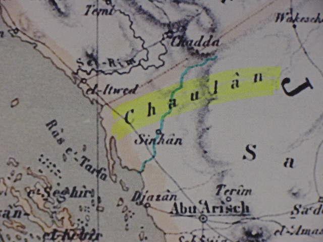
Below, Wadi Baysh (Wady Baish on earlier maps), a possible contender for the Pishon river according to Muller. Wadi Bishah is the blue dotted line above Khamis Mushayt going by Al Maddah (cf. map titled Africa, North East. Map number 954. Paris, France. Michelin. Map scale: 1:4,000,000. 1 centimeter: 40 kilometers. 1990). This map suggests Wadi Baysh/Baish is about 60 miles or 100 kilometers in length. Sayce's Tihamah Khaulan between San'a and Mecca is apparently today in the Asir province of Saudi Arabia just south of Abha which appears on the below map. That is to say Wadi Baysh/Baish flows through this Khawlan, hence the reason Muller suggests it might be the Pishon associated with the land of Havilah. Please click here to see the Saudi Arabian Khaulan Tribal Area south of Abha. The border between Saudi Arabia and Yemen is the line of crosses (+++++++) on the below map.
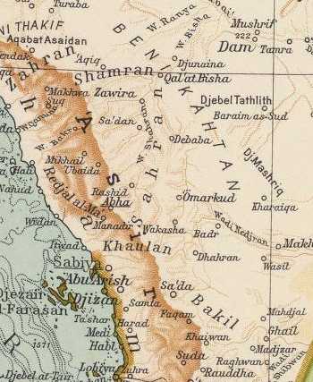
Below, another cartographical rendering of Wadi Baysh/Baish, the Pishon? (cf. map titled Near & Middle East. Hammond International. Scale: 1:4,000,000. Langenscheidt Publishing Group. Munchen [Munich], Deutschland. 2006). The map to the viewer's right reveals that Wadi Baysh (Wadi Baish on maps before 1970) is in the midst of the Khaulan (Havilah) area, draining it and providing it water, it is a very remarkable river in that it has water year-round, a rare sight in this part of the world (compare the location of Sabya on the left map with Sabiya on the right map). Also note Havilah is the "son of Joktan" in Genesis 10:26-29 and how close Khaulan is to the Beni Kahtan "Sons of Joktan" tribal federation on the below map (1929, Milan, Italy).
The Edenic Pishon River (Pison River) is Wadi Bishah (Bishain) and Wadi Baish (Baysh)
and Havilah (Hebrew: Hawila; Targum: Chavila) is the Khaulan/Khawlan/Haulan/Hawlan Yemeni Tribes?
(Please scroll down for a "Critique" of James A. Sauer's 1996 article identifying the Pishon River with Wadi Batin and Havilah with Mahd adh-Dhahab)
Please Click Here for maps showing the four rivers of Eden arising from one stream, including the Tigris (biblical Hiddekel)
16 June 2006 (Revisions through 15 May 2011)
This article in a nutshell:
Since 1875 (for over 100 years) the Pishon/Pison River associated with the land of Havilah has been identified by some scholars with Wadi Baish (Baysh) and Havilah with the Khaulan in SW Arabia, present-day Saudi Arabia near the Asir mountains. Two wadies, Bishah (Bisheh) and Baish (Baysh) are understood to have been conflated and identified with the Pishon/Pison.
Strong notes Havilah is pronounced in Hebrew with a Ch or Kh sound Khav-ee-law':
"Strong # 2341, Chaviylah, khav-ee-law', probably from # 2342 Chuwl, khoolor Chiyl, kheel, a primitive root, to twist or whirl in a spiral manner."(James Strong. Strong's Exhaustive Concordance, Complete and Unabridged. Hebrew and Chaldee Dictionary. Waco, Texas. Word Books. 1977)
I note that Hebew "w" can also be rendered "u" or "o" and that Chuwl/Khool is the possible "root form" of
Havilah/Khav-ee-law, if this be so, then the Arabic form Khaulan/Khawlan on the below maps seems (?) to preserve the Hebrew Havilah's root of Chuwl, Khool and the Hebrew Ch/Kh sound rather than the English "soft" H pronounciation of Havilah.
Havilah,
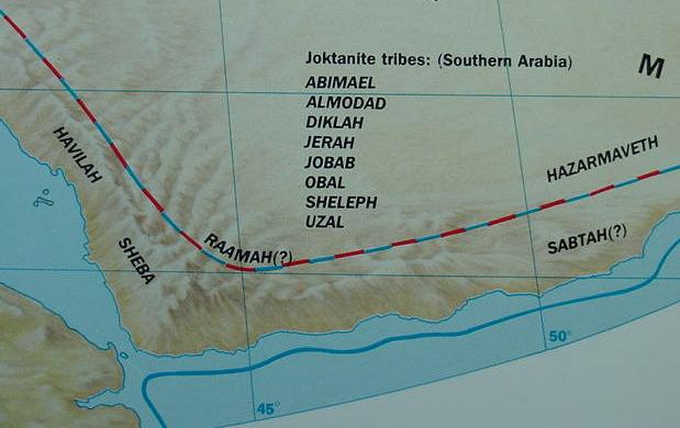
Below, a map showing Havilah (Hebrew: Hawilah) which was associated in Genesis with the Pishon river, one of the four rivers of Genesis' Garden of Eden (Ge 2:10-12). This region of South West Arabia (the Yemen and vicinity) also has the kingdom of Sheba and a region called Hazarmaveth (Arabic: Hadramawt). Genesis portrays Havilah as a land of gold, bdellium (a resin) and precious stone. The Queen of Sheba brought Solomon much gold, spices and incense (resins) and precious stones (1 Kings 10:1-13). Genesis portrays Havilah as being the son of Joktan and his brothers are Sheba and Hazarmaveth (Ge 10:26-30), localities associated with SW Arabia, the Yemen and Dhofar areas. So, Havilah and Sheba are not only brothers, their lands have similar valuable products (for the below map cf. p. 59. James B. Pritchard. Editor. The Harper Concise Atlas of the Bible. New York. HarperCollins Publishers. 1991). I have superimposed an earlier map of 1851 ("Arabia," R. M. Martin & J. & F. Tallis, New York) showing in greater detail the location of Havilah as Khaulan/Khawlan, south of Wadi Bisheh/Bishah (the Pishon River?); note that the great trade route road from Jerusalem to Havilah/Khaulan/Khawlan passes over Wadi Bishah (Note: Hebrew "-on" is a sufformative word ending and when dispensed with renders the Pishon river as the Pish); so to get to Havilah/Khaulan from Israel, one must cross the Pishon/Bishah River via this spices and incense trade route. The Jewish Targum renders Havilah as Chavilah/Khavilah, a pronunciation closer to the Arabic tribal territory and federation of Khaulan, Khawlan. Wady Bishah's headwaters drain ENE from the mountain heights of Asyr (modern: Asir). Genesis' knowledge of the Pishon and Havilah probably is a result of trade with the Queen of Sheba in the Yemen in King Solomon's time. Modern Yemeni Jews claim their Jewish ancestors came as "traders" from Jerusalem in Solomon's days and settled in the Yemen. Please click here and here for maps showing Joktan's sons as Tribal groups today.
Professor Hess on Joktan's association with South Arabia:
"Joktan...Son of Eber, brother of Peleg, and father of thirteen descendants, whose settlements ranged from Mesha to Sephar, in the hill country to the east (Gen 10:25-30). As a descendant of Shem, Joktan represents that part of the line which, in the Table of Nations, is found in South West Arabia. There is a possible relationship between the name and a figure remembered as the ancestor of the Southern Arabs, Qahtan (Winnett 1970:181; Simons GTTOT, 48-49).
Although it is unclear whether Joktan is a prefixed verbal form of the Sabaean root qtn (cf. Ryckmans 1934 1:190; Biella 1982:452), its meaning, "to be small," is associated with this root in West Semitic and appears in geographical names such as Qatna." (p. 935. Vol. 3. Richard S. Hess. "Joktan." David Noel Freedman. Editor. The Anchor Bible Dictionary. New York. Doubleday. 1992)
Professor Sayce (1898) on Havilah being the Khaulan of SW Arabia:
"Havilah...A son of Cush according to Gn 10:7, 1 Ch 1:9, of Joktan according to Gn 10:29, 1 Ch 1"23...A district of Khaulan (Haulan) is mentioned in the inscriptions of South Arabia; this is either Khaulan in Tihamah, between Mecca and San'a, or another Khaulan SE of San'a...The name, in fact, was widely spread in Arabia, and Yakut states that Hawil was the name of a dialect spoken by the people of Mehri in the east of Hadramaut [biblical Hazarmaveth]. The Mehri is the modern representative of the language of the Sabaean inscriptions." (p. 311. Vol. 2. A. H. Sayce. "Havilah." James Hastings. Editor. A Dictionary of the Bible. Originally published 1898 by T& T Clark of Edinburgh, Scotland. Reprinted 1988 by Hendrickson Publishers. Peabody, Massachusetts in 5 volumes)
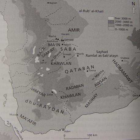
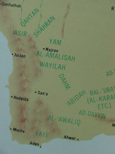
Below _two_ locations within the Yemen bear the geographical designation Khawlan (Khaulan, Haulan). A Khawlan just east of the capital of Yemen, San'a, and the other Khawlan lying further south near Radman and Himyar, said area(s) being proposed by some scholars to be Havilah (the Targum's Chavilah) of the Bible. Strangely, no Khawlan lies between San'a and Mecca as stated above by Hastings in 1898. However Muller (cf. below) cites Halevy about gold being found at Sirwah in stream beds in the Khawlan and Sirwah does appear on the below map between Saba and Khawlan, so apparently Muller favors the "gold of Havilah" to be the Khawlan east of San'a (for the below map cf. p. 37. Map 3. "South Arabia" Robert G. Hoyland. Arabia and the Arabs, From the Bronze Age to the coming of Islam. London & New York. Routledge. 2001). Special note: Muller states that there is a THIRD tribal federation in the Yemen called the "Northern" Haulan near Sa`dah. Unfortunately the below map does _not_ show the city of Sa`dah and this tribal federation. Sa`dah lies south of Najran and north of Nashq on the below map. Sayce (1898) noted a Khaulan in Tihamah between Mecca and San'a (cf. above). I have established that this Khaulan is today in Saudi Arabia in the province of Asir. It appears in a Google Saudi Arabian Gazeeter as a "Tribal Region" located to the south of the city of Abha, east of the port of Jizan on the Red Sea and west of the village of Aba Saud. The Saudi "Khaulan Tribal Area" is very near the northern border of the Yemen in the Asir mountains which border the seacoast plain called Tihamah. Please click here to see the location of the Saudi Khaulan (Sayce's Tihamah Khaulan). All this is to say that Hoyland's below map shows only TWO of the FOUR tribal federations known as the Haulan, Khaulan, Khawlan Tribal Areas. Note: Wadi Baish and Wadi Bishah are both _in_ Saudi Arabia not the Yemen.
Could the Ma'Afir be biblical Ophir, a brother of Sheba (Yemenite: Saba) and Havilah (Yemenite Khawlan), and Hazarmaveth (Yemenite: Hadrawmawt) the sons of Joktan (South West Arabian: Qahtan) (cf. Ge 10:29)?
The below extracts on Havilah the person and Havilah the region by W. W. Muller are from the
Anchor Bible Dictionary (1992. Volume 3. pp. 81-82. New York. Doubleday) (Emphasis mine):
HAVILAH (PERSON) [Hebrew hawila].
Two individuals with this name, whose identities are closely associated with the place which bears this name, appear in the Bible.
1.A son of Cush listed in the so-called Table of Nations (Gen 10:7; 1 Chr 1:9).
2.A son of Joktan listed in the so-called Table of Nations (Gen 10:29; 1 Chr 1:23).
Havilah is the biblical form of the name of the large and old tribal federation of Haulaµn in SW Arabia, which is divided into two or three branches. The identification originates from Niebuhr (1772: 292f.), who associated Haulan to the SE of San'a with Havilah, the son of Joktan, and Haulan to the W of Sa`da with Havilah, the son of Cush. He found it remarkable that two tribal districts in different regions of Yemen have the same name and are also mentioned twice in the Table of Nations (Gen 10:7, 29).
Two tribal groups of Haulan continue to exist today. The E (or S) branch are the Haulan al-Aliya or Haulan al-Tiyal, the territory of which extends from the E of San`a over Tan`im to Sirwah and into the Wadi Dana just before reaching the oasis of Marib. The N branch is the federation of the Haulan bin `Amr or Haulan Quda`a, the territory of which lies to the NW of Sa`da. The Haulan were probably originally one single tribe, the territory of which was later separated when the Minaean realm arose and the Hasid and Bakil invaded the Yemenite highland and settled there. Place names in the region of these two tribes still indicate the former presence of the Haulan. Also, in other parts of Yemen, dispersed groups of the Haulan are encountered at a later date.
The earliest epigraphic attestation of Haulan is to be found in the Old Sabean record of the ruler Karib`il Watar, set up at Sirwah, RES 3946,3, where vassals of a certain Ya`tuq of Haulan (`dm y`tq dhwln dyrrt) are mentioned. In the Minaean inscription M 247 = RES 3022,2 from Baraqis from the time about 340–330 B.C., the donors of the text give thanks to their gods for having saved them and their possessions from the raids which Saba` and Haulan undertook against them on the caravan route between Ma`in and Ragmatum (Nagran). Also in the Qatabanian inscription RES 4274,1 a member of Haulan (dhwln) is attested as a person who makes a dedication to the goddess Atirat.
In the Sabean inscriptions from the time of the kings of Saba` and Du-Raydan there are numerous references to Haulan, which can be subdivided into three different groups. The E branch is the tribe which settles around Sirwah and is called the tribe Haulan Hadilim (s`bn hwln hdlm; e.g., Iryané 28,1); through common leaders it is closely connected with the tribe of Sirwah and Hainan (s`bn srwh whwln hdlm whynn; e.g., Fakhri 3,2). In the genealogy of the N Haulan around Sa`da, which in Islamic times are the Haulan bin `Amr, the older name Banu Gudad or al-Agdud is still quoted by al-Hamdani (1965: 143–45). In the inscriptions these are the tribe Haulan Gudadim (sû`bn hwln gddm; Ja 577,8) or the tribe Haulan Gudadan (s`bn hwln gddn; Umm Lailà 1,1–2) or the groups of Haulan `Agdudan (`sûr hwln `gddn; Ja 658,13); the largeness of Haulan is sometimes expressed by the plural `s`bn placed in front of the name (“the tribes of Haulan;” Ja 601,10) or by the designation “the tribes and groups of Haulan Gudadim” (`s`b w`sr hwln gddm; Ja 616,12); their territory is the land of Haulan Gudadim (`rd hwln gddm; Ja 2109,4) or Haulan Gudadan (`rd hwln gddn; Ja 601,5) respectively, or the land of Haulan `Agdudan (`rd hwln `gddn; Ja 658,10). Once the term Haulan Gudadatan (hwln gddtn; Ja 671,5) is found. In pre-Islamic times there existed in SE Yemen around the town of Wa`lan in the ancient district of Radman a further branch of Haulan, which is often attested in the inscriptions of the 2d and 3d centuries A.D., namely, the tribe of Radman and Haulan, the leaders of which came from the clan Ma`ahir and Du-Haulan (bn m`hr wdhwln qyl rdmn whwln; e.g., RES 3958,1–2). W. W. Muller.
HAVILAH (PLACE) [Hebrew hawila]
The rich land surrounded by the river Pishon according to the story of the Garden of Eden (Gen 2:11). Its richness derives from the gold, resin bdellium, and onyx stones present there. All three of these products point to S Arabia as the location of Havilah, since S Arabia is the homeland of valuable resins and precious stones. According to Pliny (Natural History 12.23), the tree which yields bdellium also grows in Arabia, and the resin from Commiphora mukul, Arabic muql, is up to now a Yemenite product (cf. Schopen 1983: 176f.). Onyx (Arabic gaz`) is found at all times in various places in Yemen; and among the sorts which were usually named after the places where they were found, there was also a “Haulanite onyx” (al-Hamdani 1884: 202–3). Among the gold mines of the Arabian peninsula, the mine of `Asam in the region of the Quda`a is attested, the gold of which is red and excellent; also attested are the mines of al-Qufa`a in the land of Haulan, which yield gold of a superior quality (cf. al-Hamdani 1968: 138–41). J. Halévy reports that, as an eyewitness in 1870 in Sirwah in Haulan, he saw Arabs washing gold and noted that gold was found in small grains in the sand and in the river bed (1872: 54). Since in Old South Arabic dhb does not only mean gold but also a type of incense, it is possible that zahab tob in Gen 2:12 does not refer to “good gold” but rather to a fragrant resin (cf. de Langhe 1959: 493).In Gen 25:18 hawila, which by the Israelites might have been connected with Hebrew hol, “sand,” designates presumably the SE desert border of the region where the Ishmaelites settled. From this fact and from the reference to the Chaulotaîoi by Eratosthenes (Strabo, Geog. 16.4.2), H. von Wissmann (1970: 905–80, esp. 947–54) concluded that there must have existed a colonial Sabean Haulan in NW Arabia along the incense road before or perhaps still during the Minaean period in the oasis of Dedan. Probably this N Arabian hawila is to be distinguished from the S Arabian Haulan and perhaps to be compared with the tribe of hwlt, which is repeatedly mentioned in the Safaitic inscriptions and which might be identified with the Avalitae of Pliny (HN 6.157) and the later Arabian tribe of Hawala. Possibly the old biblical name of this region survives in the name of the N Arabian town of Ha`il (cf. Knauf 1985: 64). The borders of the Ishmaelites in Gen 25:18 with the local destination hawila have also been taken over in 1 Sam 15:7 and transferred to the Amalekites.
It should also be noted that other less convincing identification of hawila have been proposed, e.g., in the central Arabian Yamama, in NE Arabia at the Persian Gulf, or even with Avalites (Periplus maris Erythraei 7; Ptolemy, Geog. 4.7.10), the later Zayla` at the NE African coast. For further bibliography, see Westermann (1984: 214–15).
W. W. Muller.
According to Genesis 10:26-30 Joktan and his progeny are enumerated as Joktan, Almodad, Sheleph, Hazarmaveth, Jerah, Hadoram, Uzal, Diklah, Obal, Abimael, Sheba, Ophir, Havilah and Jobab, living in a region described as extending from Mesha to Sephar and the hill country of the east.
The below maps showing the locations of various Arab tribes (as of 1968) and may be of some help in identifying the location of some of Joktan's "sons."
The tribe called Qahtan (in the province of Asir, Saudi Arabia) might be Joktan. Of interest is that Wadi Bishah lies just about where the word Qahtan is. Genesis suggests the Pishon river surrounds the land of Havilah (Hebrew: Hawila) which might be the tribal group called Wayliah, south of Wadi Bishah (the Pishon?), which lies _north_ of Sana'a the capital of Yemen. Note: Muller (cf. above) places a "northern" Haulan tribal federation in the area of the city of Sa`dah, which although not on the below map is just about where the tribal group called the Wayliah are located. Another tribal group is the Al-`Awaliq _south_ of Sana'a near Radman which does not appaear on the below map. "Missing" from the below map is the tribal "south" federation of Haulan centered to the east of Sana'a and extending towards ancient Marib (cf. p. 54. "Tribal Map of the Arabian Peninsula." Aramaco Handbook, Oil and the Middle East. Dhahran, Saudi Arabia. Arabian American Oil Company. Revised Edition 1 July 1968. Library of Congress Catalog Card Number 68-24022. Printed in the Netherlands by Joh. Enschede en Zonen-Haarlem. Note: no author or editor's name is given for this book).
Could Ophir, identified with the fine gold of Ophir in the Bible be recalled in the tribal group called al-'Ifar, in Dhofar (Zhufar on some maps), west of Wadi Hadrhramaut (some scolars identifying Joktan's son Hazarmaveth with Hadhramawt)?
Could the tribal lands of Joktan and his sons said to extend from Mesha to Sephar and the hill country of the east be alluding to present-day Khamis Mushayt, in the mountains of Asir (Saudi Arabia) lying just south of Qahtan (and north of Najran) and could Sephar and its eastern hill country be modern-day Dhofar and its hill country (famed for its frankincense trees), alternately rendered on some maps as Zufar or Zofar? This region is a land of precious stones, incense and gold, items associated with Joktan's patrimony (Sheba, Havilah, Ophir). The main caravan route appears to have left the Yemen heading north to Najran and Khamis Mushayt. That is to say "if" Mesha is Mushayt, it was a major stop on the caravan route to Israel from the Yemen?
Below, a "Metallic Minerals Map" of the Yemen showing some 19 locations possessing GOLD as a mineral resource (the small olivedrab green circles mark gold bearing lodes). Is it any wonder Havilah was "the land of gold" with 19 locations? The Wayilah are located north of San'a and in this same general area are approximately 6 or 7 locations for gold. Please click here for an "interactive version of the below map which allows one to scroll through the various regions of the Yemen. The Google internet search engine by keying in "Yemen Gold" offers numerous articles by Geologists on this region's gold bearing sites including articles on Iron Age Gold-processing Camps of the first millennium BC (the World of Solomon and the Queen of Sheba).
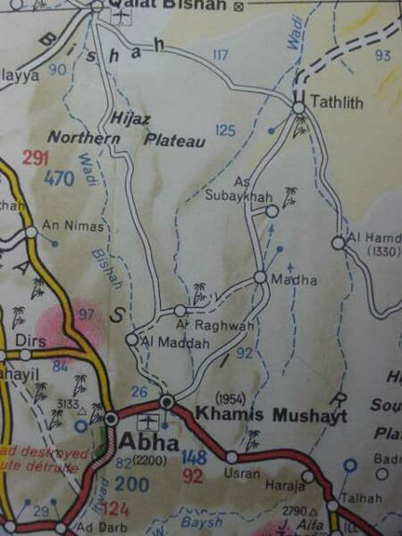
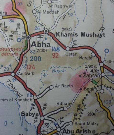
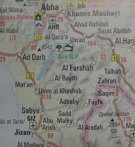
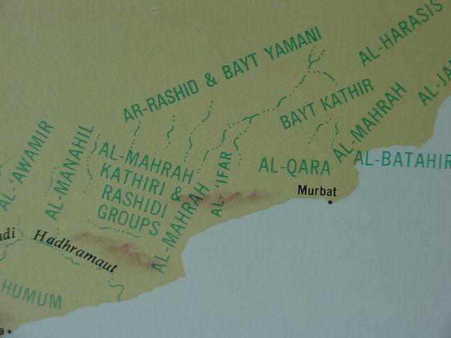
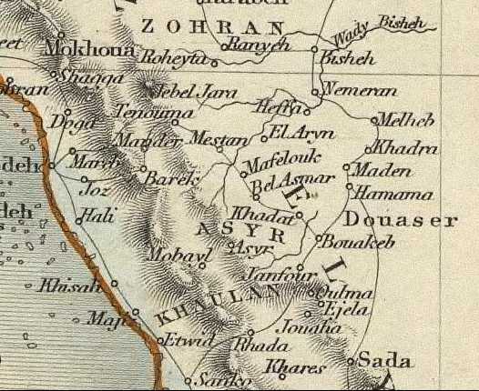
Below, Wadi Bishah, divided into three maps for clarity. (cf. Map titled Africa, North East Arabia. Michelin. No. 954. Paris, France. Scale: 1:4,000,000. 1990)
Below, another map showing Wadi Bishah as Wadi Bishain. If Bishain is not an "error," and if it is a legitimate alternate rendering of Bishah, could the "n"preserve the Pishon? (cf. Map titled Near & Middle East. Hammond World Atlas. Scale: 1:4,000,000. Langenscheidt Publishing Group. Munich, Germany. 2006)
Please click here for a "Rough Tribal Map of Arabia." 1949. H. R. P. Dickson. The Arab of the Desert. London.
To "enlarge" this map place your mouse on the map's lower right corner and a square will appear to click on, enlarging it.
The Queen of Sheba brought Solomon gold, incense, spices and precious stones. According to the below article by Bouton such items are attested for the Yemen in the Iron Age (Note that the Iron Age Gold Mines of the al Maraziq region are located in the al Jawf/Jof region northeast of Sana'a on the above minerals map):
"At present there is no archaeological evidence to prove that the meeting of Solomon and Sheba took place, or that the queen actually existed. But, recent excavations have found that some aspects of the story can be verified. This exhibition investigates these aspects and aims to shed light upon the mysterious but magnificent civilization of ancient Yemen, the land of Sheba.
Some scholars have disputed the Old Testament passage on the basis that the Queen of Sheba’s gifts - spices, gold and precious stones - are inconsistent with her homeland in southern Arabia. However these are not as incongruous as it may at first seem. The ‘spices’ mentioned are likely to be a reference to aromatics principally burnt in religious rituals in the temple and the home. Foremost among these were frankincense and myrrh, both natural gums which exuded from their
trees after the bark was scraped away. A number of ancient incense burners found in Yemen are even inscribed with the names of different aromatics. In terms of the ‘gold’, geological surveys (most recently in the Maraziq area of the Jawf region of northern Yemen) have uncovered the remains of ancient camps and ore-crushing and grinding equipment. These have been found close to ancient test pits and mines running along quartz veins exposed on the surface. In addition, a small collection in the British Museum of high-quality gold beads, earrings, bracelets and appliques suggest these are the work of a previously unrecognized high-quality goldworking tradition. Examples of this goldwork can be seen in the show. Detailed depictions on funerary sculptures of necklaces, earrings, armlets and finger rings offer a further glimpse of the types of high-status jewellery worn by men and women alike. Certain ‘precious stones’ such as coloured chalcedonies occur naturally in Yemen; other types were probably imported from India and Somaliland. These stones were popular across the Near East for carving beads and seals."
(cf. Ms. Hannan Bouton, Press Officer for the British Museum, London.
"The Queen of Sheba: Treasures from the Ancient Yemen."
9 June-13 October 2002 Exhibition sponsored by Barclays PLC)
A report assessing potential gold lodes in the Yemen made in 2007 has identified some 12 locations, cf. "Investment Opportunities in the Metallic Minerals Sector in Yemen. Evaluation and Promotion." Republic of Yemen. Ministry of Oil and Minerals. Geological Survey and Minerals Resources Board. 2007(Please click here for the report).
Twelve locations in the Yemen have been surveyed as possibly being gold-bearing:
(Note: Wadi al Jawf and its tributaries lies southeast of Sa`dah and northeast of Sana`a)
1. Wadi Rubaq (Al Jawf)
2. Wadi Al Mamasah (Al Jawf)
3. Al Matammah (Al Jawf)
4. Wadi Falahan (Al Jawf)
5. Shaharah (Amran)
6. Bahrah (Marib)
7. Khowlan (Sana'a)
8. A'ithayn (Dhamar)
9. Waraqah (Dhamar)
10. Magrebah (Dhamar)
11. Al Waz'yyah (Taiz)
12. Am Surrah-Habalain (Abyan)
The report noted:
"Metallic minerals are not currently (2006) being mined in Yemen. During ancient times...silver was mined...and gold from small quartz veins scattered over northern and western Yemen."
Cf. below a report on Iron Age gold mines in the Yemen, King Solomon and the Queen of Sheba were Iron Age monarchs, Note: the al Maraziq area is located within the al Jawf region northeast of Sana'a, the capital of Yemen:
Leanna Mallory-Greenough, John D. Greenough & Charles Fipke. "Iron Age Gold Mining: A Preliminary Report on Camps in the Al Maraziq Region, Yemen." Arabian Archaeology and Epigraphy. Vol. 11. No. 2. Nov. 2000. pp. 223-236.
"Abstract:
Ancient geologists in Yemen and Egypt recognized that quartz veins surrounding caldera-collapse complexes (exhumed explosive volcanoes) were gold bearing and actively sought out these geologic environments. Rock hammerstones, anvils and grinders are found in camps on both sides of the Red Sea, indicating that mining and metallurgical extraction technology and knowledge were also widespread during the Iron Age. The technology and overall layout of the Yemen sites is equivalent with New Kingdom to Late Period Egyptian sites, and there is no evidence of smelting, which is a Greco-Roman Period development. It is not known who controlled the Yemen mines, but the large number of adits in the Al Maraziq area suggests that these gold mines may have been important to local, regional and possibly international economies."
An internet map search for al Maraziq gives the following co-ordinates:
Latitude: 14 degrees 25' 0
Longitude: 46 degrees 34' 0
These co-ordinates place al Maraziq in the al Jawf region ENE of Sana'a (cf. the below map for al Jawf).
Leanne Mallory-Greenough et al. (My thanks to her for providing me a copy of her below article):
"The Yemen ore deposit may have been discovered because it was close to trading routes, or trade route proximity may have been a product of gold exploitation." (p. 223. Leanne Mallory-Greenough et al. "Iron Age Gold Mining: A Preliminary Report on Camps in the Al Maraziq Region, Yemen. Arabian Archaeology and Epigraphy. Vol. 11. No. 2. Nov. 2000. pp. 223-236.)
"Five ancient mining sites were visited in the Al Maraziq area, Al Jawf region, northern Yemen...A tape measure and compass were used to survey building and artefact positions...Excavations were not attempted. Al Maraziq inhabitants contend there are over 200 ancient adits in the area and at least one ancient community we did not visit..." (p. 225. Leanne Mallory-Greenough et al.)
"The ore processing technology found in Yemen was widespread in the Near and Middle East at about 1000 BCE, and can be found at Egyptian/Nubian sites ranging from the New Kingdom to Late Period, reaching a peak during the twenty-sixth Dynasty." (p. 233. Leanne Mallory-Greenough et al.)
"Based on the technological similarities with Egyptian gold mines, Yemen sites may range from Bronze to Iron Age. Preliminary thermoluminescence measurements on pottery from site 4 are consistent with the presumed antiquity of the site. The stone block bearing South Arabian script (Sabaean) suggests site 1 was occupied at some time between 800 BCE and 600 CE although mining may have occurred earlier. There is no information about how long mining went on at the Yemen sites. Mines in southeast Egypt and Nubia were mined for over two thousand years with individual mines first opened during the Middle Kingdom, re-opened in the New Kingdom, Late Period and Greco-Roman times." (p. 234. Leanne Mallory-Greenough et al.)
"It appears that the Yemen mining camps are close to the frankincense trade route. It is not known if the trade route existed because of the gold or if the deposits were discovered as a result of through traffic. Legend (Sheba's gifts to Solomon) suggests the gold trade was internationally important. Regardless of whether these stories are true, processing and geological (prospecting) similarities between Iron Age gold mines in Yemen and Egypt suggest ties and an exchange of technological knowledge between distant places in the Near and Middle East." (p. 234. Leanne Mallory-Greenough et al.)
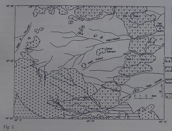
Below, a map (figure 1. p. 224. Leanne Mallory-Greenough, et al.) showing the location of the gold mines marked off as "Study Area" (NE of Sana'a) and a close-up map showing a Wadi Kuhayl in the area of the mines. To the degree that Strong derives Havilah from Chuwl, khoolor Chiyl, kheel (Strong 2342), might Wadi Kuhayl preserve the Hebrew Chaviylah, khav-ee-law'' English, Havilah and its gold?
That is to say Havilah is _not_ the Khaulan and Wadi Baish, but instead, Havilah is Wadi Kuhayl and the nearby 200 adits of gold! Mallory-Greenough noted this gold-bearing area is near the great trade route from the Yemen to Jerusalem and Judah. Trade caravans from Jerusalem would be the source of the Jews' knowledge of a great river called the Pishon, perhaps Wadi Bishah, which the route crosses at Qalaat Bishah and continues on to the Jauf region and Wadi Kuhayl (Havilah, chuwl, kheel?).
Below, a larger map of Wadi Baysh/Baish (apparently printed in Japanese?) showing the stream reaching the Red Sea just north of the port of Jizan, the Baish's (Baysh's) "numerous tributaries" are not shown on any of the maps accompanying this article because I was unable to find such maps on the internet. The Yemen, not on the below map, is south of the dotted line border of Saudi Arabia.
Philby (1936) on Wadi Baish tributaries:
"For the first two hours...of our march...the steep slope of the Baid massif formed the right bank of the Baish...hemmed in...by...the Jabel Raith...whose ravines head no fewer than eighteen tributaries of Baish down to our...camp at Mishaqa...bordering the Tihama plain."
(p. 450. H. Sr. J. B. Philby. Arabian Highlands. Ithaca, New York. Cornell University Press. Published for
The Middle East Institute of Washington D.C. 1952)
I have _not_ consulted the following work which would probably be very useful to anyone seeking to identify biblical Joktan and his sons:
Richard Trench. Gazetteer of Arabian Tribes. 18 Volumes. Cambridge Archives Series. Cambridge, United Kingdom. 1996. With 6 maps showing various tribes and clans. It sells for 5,000 British Pounds Sterling (USA $10,000.00).
Book Description: Archive Editions Ltd (Cambridge University Press), 1996. Hardback. Book Condition: Brand new hardback. 17.64 by 17.6 inches. (12,000 pages). The Gazetteer provides a magnificent collection of historical descriptions of Arabian tribes from British archival sources in the 19th and 20th centuries. Some 745 tribes are included, representing most of the major clans and families in the Arabian peninsula. From Iraq and Syria the geographic coverage includes Jordan, Saudi Arabia and the Gulf States to Oman, the Hadhramaut and Yemen. The records show territories and nomadic routes, tribal relations and allegiance, military strength, personalities and modern influence. These volumes provide the broadest array ever assembled of English language historical references concerning approximately 745 tribes, tribal confederations and clans in the Arabian peninsula. It is likely to remain the definitive research work for tribal history. From the eyewitness accounts of the Hijaz tribes riding into battle in 1917 to a social and political breakdown of the Jaburi tribe of Iraq, this gazetteer is an important resource to the study of Arab history.
As noted earlier, if Wadies Baish (Baysh) and Bishah (Bisheh) have been conflated into the Pishon how does one account for the Pishon with the Euphrates and Hiddekel (Tigris) emanating from one stream that watered Eden's garden (Ge 2:10-14)?
Quite simply, the Edenic account is mythical, it is _not_ based on geological or geographical reality as revealed by the scientific disciplines of Geology and Hydrology. The Euphrates and Tigris _never_ in all of geological history emanated from one stream, each arises from its own tributary system of interconnecting rivers.
Professor Sarna (a Jewish Rabbi) suggests as much, believing that Genesis' author magnaminously wanted to portray all the famous rivers of his day as emanating from one stream. Sarna also notes that the Eden narrative is probably no older than the 7th century BC, others have suggested the 6th century BC and the Exile:
"A single river issues from Eden. Its source appears to be outside the garden...beyond the confines of the garden the single river separates into four branches that probably represent the four quarters of the inhabited world. In other words, the river of Eden also nourishes the rest of the world with its life-giving waters. While the Tigris and Euphrates are of course well known, the other two names defy positive identification. They may stand for another great river civilization corresponding to that of the Mesopotamian plain, perhaps the Nile valley."
(p. 19, Nahum M. Sarna, Editor. The Jewish Society's Torah Commentary-Genesis. The Jewish Publication Society. New York. 1989)
If the account is 6th century BC, as I suspect, then we have an answer as to why the Pishon in SW Arabia and Nile-Gihon in Cush/Sudan is conceived as emanating with the Tigris and Euphrates rivers from one great Edenic stream, this is a 9th-7th century BC Homeric (Homer dated generally to the 9th-7th centuries BC) Greek notion which postulated that _all_ rivers emanated from a freshwater River Ocean (Greek: Okeanos) which encircled the world and via underground streams erupted in various parts of the world as rivers!
Judah was under Egyptian vassalage following the death of King Josiah at Megiddo (ca. 640-610 BC) slain in battle attempting to stop Pharaoh Necho from coming to Assyrian assistance at the Euphrates and Carchmesh. Greek mercenaries apparently were stationed in Judah by the Egyptians to control the province and put down any revolts. Via either these mercenaries or Greek traders Judah, before she went into Exile (ca. 576 BC), came to know of a great river which was the source of _all_ the world's rivers and this would include streams in Mesopotamia, SW Arabia (Yemen) and Cush (Africa).
Homeric River Ocean as the source of _all_ rivers:
"In ancient Greek cosmology the RIVER OKEANOS was a great, fresh-water stream which circled the flat earth. It was the source of all of the earth's fresh-water--from the rivers and springs which were fed by subterranean aquifers, to the clouds, which dipped below the horizon to collect moisture from its stream.
Okeanos also marked the outer boundaries of the flat earth which it encircled with a nine-fold stream. The sun, moon, and stars were all believed to rise and set into its waters."
Thus, in my opinion, Professor Sarna "errs," the Jewish narrator wasn't being "magnaminous" in visualizing various streams in different parts of the world as emanating from one stream, he apparently believed such nonsense via the Greek traders and mercenaries present in Judah circa the 8th-6th centuries BC!
Professor Sarna on Genesis being no earlier than the 7th century BC:
"The difficulty, however, lies with the designation "Ur of the Chaldeans." The name "Chaldeans" as applied to lower Mesopotamia does not appear before the eleventh century B.C.E., many hundreds of years after the patriarchs. The city of Ur itself could not have been called "of the Chaldeans" before the foundation of the Neo-Babylonian empire in the seventh century B.C.E. The characterization therefore, as distinct from the tradition, would seem to be anachronistic."
(p. 98. "The Problem of Ur." Nahum M. Sarna. Understanding Genesis. New York. Shocken Books. 1966. reprinted 1970)
Professor Stern on Greeks in Judah by the 7th-6th century BC:
"The findings at Mezad Hashavyahu and Migdol led some scholars to assume a cluster of fortresses in the Judaean kingdom partly manned by Greeks, especially during the reign of Josiah...Yigael Yadin accepted Aharoni's view that the kittiyim were Greek soldiers stationed in the garrison at Arad...From this combined evidence of both written documents and archaeological remains, it appears that, even before the arrival of the Assyrians, but mainly during and after their period of domination, there was Greek penetration into Palestine by both traders and mercenaries. No discussion of the archaeology of Palestine of this period can ignore them, and in any case, their presence here seems to reflect somewhat more than the results of regular trade relations alone, as was recently suggested by J. Waldbaum."
(pp. 226-7. Ephraim Stern. "The Greek Penetration, The Population in 7th Century B.C.E. Phoenicia and Palestine." Ephraim Stern. Archaeology of the land of the Bible, The Assyrian, Babylonian and Persian Periods,
732-332 BCE. Anchor Bible Reference Library. New York. Doubleday. 2001.)
The Jewish historian Flavius Josephus (70-80 AD) understood Eden's stream was the source of a Pishon/Ganges in India and Gihon/Nile in Egypt/Cush (Sudan), mirroring somewhat the Homeric Greek notion that all rivers emanate from a mythical fresh-water oceanic stream that encircles or "runs about" the earth:
"Moses says further, that God planted a paradise in the east...Now the garden was watered by one river, which ran about the whole earth, and was parted into four parts. And Phison, which denotes a multitude, running into India, makes its exit into the sea, and is by the Greeks called Ganges...Geon runs through Egypt, and denotes what arises from the east, which the Greeks call Nile."
(pp. 29-30, Flavius Josephus. The Antiquities of the Jews. Book 1, chapter 1, section 3.37-39. The Works of Josephus. [William Whiston, translator]. Hendrickson Publishers. Peabody, Massachusetts. 1987)
Professors Graves and Patai (1964) on Greek mythological concepts appearing in the 6th century BC book of Genesis and its Garden of Eden narrative:
"...Genesis, which is far more closely linked with Greek, Phonenician, Hittite, Ugaritic, Sumerian and other bodies of myth than most pious Jews and Christians care to admit, was thereafter edited and re-edited from perhaps the sixth century BC onwards, for moralistic ends."
(p. 14. "Introduction." Robert Graves and Raphael Patai. Hebrew Myths, the Book of Genesis. Garden City, New York. Doubleday & Company. 1964)
"Some elements of the Fall of Man myth in Genesis are of great antiquity; but the composition is late, and even in places suggests Greek influence."
(p. 78. "The Fall of Man." Robert Graves and Raphael Patai. Hebrew Myths, the Book of Genesis. Garden City, New York. Doubleday & Company. 1964)
It would appear then, that Judah's knowledge of the Greeks' notions about a mythical fresh-water River Okeanos as the source of all rivers arose in the course of the 7th through 6th centuries B.C. _before_ the Primary History (Genesis-2 Kings) was written ca. 562-560 B.C. in the Exile.
Scholars who attempt to identify the Pishon and Gihon as being in the vicinity of Mesopotamia's Tigris and Euphrates rivers, err, in my opinion, unaware that a Homeric Greek 9th-7th century BC mythical world-encircling freshwater-river Okeanos (the single source of _all_ the world's river in myth) is most probably behind Genesis' Edenic stream.
"Other" Havilahs in the Bible?
We are told that King Saul pursued the Amalekites "from Havilah to Shur that is before Egypt" (1 Samuel 15:4-10). It is very unlikely that Saul attacked the Havilah associated with the Pishon River in SW Arabia as the distance is just too great. Some clues that the Amalekite Havilah was not in SW Arabia and the Khaulan:
(1) The Amalekites inhabit the Negeb (Nu 13:29) and the vicinty of Kadesh/En Mishphat in the wilderness of Zin/Paran (Ge 14:7 ) and the Hebron/Seir Hill Country (Nu 14:44-45) from which they range into the Sinai as far as Shur that is before Egypt attacking Israel at Rephidim before Israel reaches Mount Sinai (Ex 17:8).
(2) The Kenites are warned to separate themselves from the Amalekites by Saul (1 Sam 15:6). The Kenites are portrayed as having settled in the wilderness of Judah in the Negeb associated with Arad at the foot of the Hebron/Seir Hill Country (Jdgs 1:16). The wilderness of Judah is usually associated with the Hill Country flanking the western shore of the Dead Sea. Arad lies S of this Hill Country and the Kenites near Arad's negeb might be preserved at Wady el Keni near ez Zuwera, E of Arad.
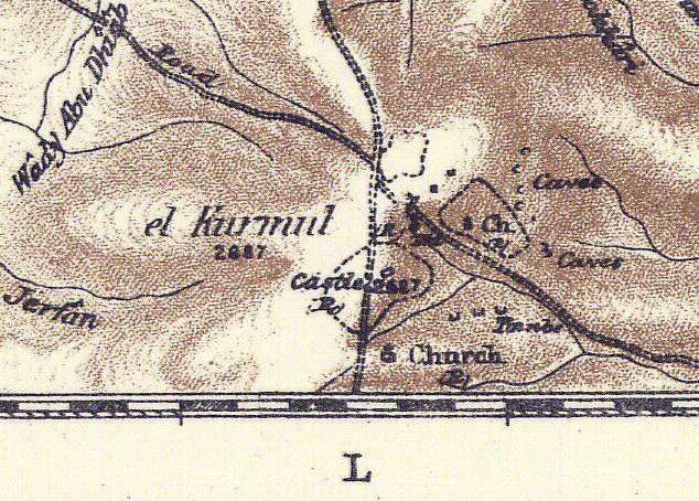
(3) Saul assembles his troops in Judah at Telaim/Telem before the attack on Amalek.(1Sam 15:4) Telem, is near Ziph Tell ez Zif S of Hebron and N of Kurmul (Jos 15:24)? After his victory over Amalek he celebrates at Carmel (1 Sam 15:12) Telem/Telaim is near Ziph (Jos 15:24), perhaps Ziph is Tell ez Zif (PEF 1878) N of el Kurmul which might be Carmel? Could Tell Main S of Kurmul/Carmel be Telem?
(4) "The city of Amalek" (a village or tent encampment?) is attacked and apparently it is in the vicinity of Havilah and from it they flee to Shur.
Does there exist in the vicinity of the Carmel/Kurmul in the "wilderness of Judah" a location called Havilah recalling that the Hebrew pronunciation is Chaviylah, khav-ee-law' derived from Chuwl, khoolor Chiyl, kheel?
Arabic is not Hebrew so allowances need to be made for its preservation of the Hebrew word and its pronunciation.
Perhaps Saul's Havilah (Chaviylah, khav-ee-law'') is preserved in Arabic in its Hebrew "root" form as either Chuwl, khoolor Chiyl, kheellike the Arabic Khawlan/Khaulan of SW Arabia (Yemen & Saudi Arabia).
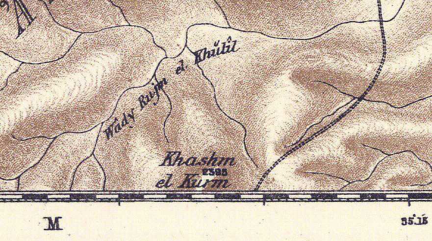
"If" Havilah is associated with the Hill Country, more specifically the wilderness of Judah east of Carmel/Kurmul might Havilah be preserved at Wady Rujm el Khulil (preserving the Hebrew root: Khool, Kheel) to the E of Carmel/Kurmul (Palestine Exploration Fund Map. Sheet 21. London. Scale: 1:63,000)?
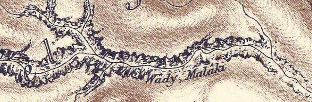
Just N of Wady Rujm el Khulil is Wadi Malaki perhaps preserving Amalek? Did Saul launch his attack eastwards from Carmel/Kurmul and Tel Main (Telem?) on the Amalekites at Wadi el Malaki via Wady Rujm el Khulil (Havilah)? He apparently swept them before him towards the Dead Sea in the wilderness of Judah east of Carmel and southwards along its shore to the vicinity of the Kenites at Wady el Keni E of Arad to the ascent of ez Zuwera (modern Israeli Rekhes Zohar)?
If these proposlas are on the mark then Havilah to Shur to to the E of Carmel/Kurmul and Telem/Tell Main in the wilderness of Judah bounded on the east by the Dead Sea. If Shur is ez Zuwerah by wady Keni, then Havilah to Shur is a very small area, restricted pretty much to "the wilderness of Judah" bounded on the south by the Kenites near the negeb of Arad as suggested in the Bible.
Below Carmel (Kurmul?) S of Hebron where Saul celebrated his victory over the Amalekites after pursuing them from Havilah to Shur (PEF 1878 Sheet No. 21 ):
Havilah according to Strong's Hebrew and Chaldee Dictionary is wrongly pronounced in English as "Havilah" its correct pronounciation in Hebrew apparently is Chavilah or Khav-ee-law':
"Strong # 2341, Chaviylah, khav-ee-law', probably from # 2342 Chuwl, khoolor Chiyl, kheel, a primitive root, to twist or whirl in a spiral manner."(James Strong. Strong's Exhaustive Concordance, Complete and Unabridged. Waco, Texas. Word Books. 1977)
Muller on Havilah:
"Havilah, Hebrew: hawila. The rich land surrounded by the river Pishon..."
(p. 82. vol. 3. W. W. Muller. "Havilah." David Noel Freedman. Editor. The Anchor Bible Dictionary. New York. Doubleday. 1992)
Below, a map (1862) showing Havilah as the Chaulan region being watered by Wadi Baish (the Pishon river of Garden of Eden fame?) in lightblue marker, "abundant in water," descending south from the Asir mountains to the Red Sea (Heinrich Kiepert, Cartographer. Germany). As noted by Muller (1992) Wadi Baish was identified by Springer in 1875 with the Pishon that waters the land of Havilah, the Jewish Targum's Chavilah/Khavilah (the Khaulan or Chaulan). I suspect that Springer (1875) is correct and Muller (1992) too in that Wadi Bisheh/Bishah has been conflated with the Baish/Baysh. Havilah's gold and onyx stone (biblical shoham stone) would be mined in the mountains of SW Arabia associated with the tribes of this area the Kahtan (Joktan), Khaulan (Havilah) and Saba (Sheba).
_My_ "Critique" of the Pishon River being the "Kuwait River" (Wadi al Batin) as proposed by the late James A. Sauer in 1996:
The late James A. Sauer (died 1999) suggested in 1996 that the Pishon river might be Wadi al-Batin also called the "Kuwait River" because it drains from an area near Mahd adh-Dhahab,"the cradle of gold," an ancient gold bearing region worked in antiquity in western Saudi Arabia, this river ends near modern Kuwait.
Below a map showing the so-called "Kuwait River" alternately, Wadi Batin, which Sauer proposed might be Eden's Pishon River, draining from the area of Mahd adh-Dahab (viewer's lower left). The Gihon is identified on the below map with the Iranian Karkheh River draining from the Zagros mountains and ancient Susa (viewer's right):
Sauer, _in error_ thought that Mahd adh-Dhahab was the "only area" possessing gold in antiquity. As revealed by geological surveys conducted in the Yemen (cf. above Mallory-Greenough, 2000) gold mines also existed in antiquity in the Yemen. Sauer consequently proposed in 1996 that Havilah, famous for its gold, was most probably the vicinity of Mahd adh-Dhahab and Medina in western Saudi Arabia. In 1996 when Sauer wrote his article the Iron Age Gold Mines at al Maraziq in the al Jawf region of the Yemen had not yet been identified, that event would occur in 2000, one year _after_ Sauer's death in 1999. Because in 1996 Mahd adh-Dhahab was _the_only_"verified" ancient_gold_mine_in Arabia known to scholars he understandably associated it with Havilah's gold.
The below quotes are from James A. Sauer, "A Lost River of Eden, Rediscovering the Pishon." pp. 3-11, in Molly Dewsnap Meinhardt, editor, Mysteries of the Bible, From the Garden of Eden to the Shroud of Turin. Washington, D.C. Biblical Archaeological Society. 2004. This is apparently a reprint, with a different title, of James A. Sauer, "The River Runs Dry: Creation Story Preserves Historical Memory." The Biblical Archaeology Review, Vol. 22, No. 4, July/August 1996, pp. 52-54, 57, 64. The late James A. Sauer was a Curator and Research Associate at Harvard's Semitic Museum and considered an authority on the archaeology of Jordan he died in 1999.
Sauer on Mahd adh-Dhahab being the _only known_ site for Arabian gold, which he uses "to fix" the location of the land of Havilah and its Pishon River:
"An important key is the Biblical phrase "the gold of that land is good." Only one place in Arabia has such a deposit -the famous site of Mahd edh-Dhahab, the "Cradle of Gold." This ancient and modern gold mine is located about 125 miles south of Medina, near the headwaters of the Kuwait River."
(p. 8. James Sauer."A Lost River of Eden, Rediscovering the Pishon.")
To his credit, Sauer did acknowledge a "problem" with his Havilah proposal, that bdellium also associated with Havilah (a resin), appears to be unknown as a physical resource near Mahd adh-Dhahab or Medina, it is a resource however of the Yemen. To get around this "problem" he proposed that the Yemen's bdellium was "traded" in the Medina area and thus came to associated as a physical resource of Havilah:
"The Biblical text also mentions bdellium and onyx. Aromatic resins such as bdellium are known in Yemen to the southwest, and, although they are not thought to have been produced in the vicinity of Medina, they could easily have been brought there."
(p. 8. James Sauer. "A Lost River of Eden, Rediscovering the Pishon.")
Another "problem" acknowledged by Sauer was Havilah's precious stones. Again he acknowledged that the area of Southwest Arabia ( the modern Yemen) is famed for a variety of semi-precious stones rather than the Medina area:
"Semiprecious stones such as alabaster also come from these areas, but it is uncertain whether other precious stones, such as onyx, do. In any event, no other river would seem to fit the Biblical description. I am inclined therefore to think that the Kuwait River could well be the Pishon of the Bible."
(p. 8. James Sauer. "A Lost River of Eden, Rediscovering the Pishon.")
The problem? Havilah appears for most scholars to be associated with the Khaulan (Khawlan) in the Yemen, which also has evidence of gold mines being worked in the Iron Age. Wadi Bishah (the Pishon?)_must be crossed_ before reaching Yemen's Sheba and Haulan/Khawlan (Havilah?), perhaps this is why the Pishon is said to encircle Havilah, you must cross the Bishah before entering the gold-bearing region of the Yemen (ancient gold mines have been found to the southeast of Sa`dah in the al Maraziq area of the al Jawf region).
I understand Sauer is _wrong_ about Mahd adh-Dhahab and Medina being the region of Havilah and Kuwait River (Wadi al-Batin) being the Pishon River for the following reasons:
(1) Havilah appears for some scholars to be associated with the Khawlan tribal federation in the Yemen, no such regional name or federation exists near Medina or Mahd adh-Dhahab. Muller (cf. above) identified THREE tribal federations within the Yemen all bearing the name Khawlan or Haulan: (1.) A "northern" Haulan tribal federation near Sa`dah; (2.) An "Eastern or Southern Haulan tribal federation" near Sirwah; (3.) A Haulan tribal federation near Radman, south of Sana'a. Sayce (1898) identified a "fourth" Khaulan tribal area with the Tihamah coastline bordering the Red Sea. Today this area lies in Saudi Arabia in the province of Asir, to the south of Abha, very near the northwestern border of the modern Yemen. Pritchard's map (cf. above) shows Havilah as near the Red Sea and probably this is based on Sayce's Tihamah Khaulan in Saudi Arabia.
(2) Sauer was simply _wrong_ in his belief that the "only known source" for Arabian gold was Mahd adh-Dhahab. Geological surveys in the Yemen have identified gold mines in this area in the al Maraziq area within the al Jawf region, east of Sa`dah dating from Iron Age times and Solomon and the Queen of Sheba were Iron Age monarchs (cf. Leanne Mallory-Greenough et al. "Iron Age Gold Mining: A Preliminary Report on Camps in the Al Maraziq Region, Yemen." Arabian Archaeology and Epigraphy. Vol. 11. No. 2. Nov. 2000. pp. 223-236). Note: According to Muller the "northern" tribal federation of Haulan is located in the Sa`dah area, and just southeast of Sa`dah are Iron Age gold mining camps of the al Jawf region (Wadi al Jawf?). Were these mines identified in Genesis with the "northern" Haulan tribal federation near Sa`dah? A Jew traveling south from Jerusalem, would most like have crossed Wadi Bishah (Genesis' Pishon River?) before reaching the land of Hawila/Havilah and the area of the "northern" Haulan tribal federation at Sa`dah which may have controlled the Iron Age mining camps southeast of that location at al Jawf. Mallory-Greenough speculated about the nearness of the al Jawf Iron Age gold mines to the frankincense trade route extending from the land of Sheba and Jerusalem in King Solomon's days (cf. above).
(3) In antiquity the Yemen (Southwest Arabia) was famed for resins, most particularly frankincense of the Dhofar/Zufar region (biblical Sephar? Ge 10:30) east of Wady Hadramawt (biblical Hazarmaveth, a brother of Sheba and Havilah, cf. Ge 10:26-30).
(4) Havilah is a "brother" of Sheba and Hazarmaveth (Ge 10:26-29) and these names appear in the Yemen under Khawlan/Haulan, Saba and Hadramawt.
(5) Ophir was a "brother" of Sheba, Havilah and Hazarmaveth too. The Bible speaks of the gold of Ophir. Is it possible that the gold adits of the Jauf area came to be "morphed" into the gold of Oph[-ir] by the Hebrews? That is to say Jauf "became" Oph[ir]?
(6) Apparently unknown (?) to Sauer, the Jewish scholar Halévy reported that as an eyewitness in 1870 in Sirwah in Haulan (in the Yemen), he saw Arabs washing gold and noted that gold was found in small grains in the sand and in the river bed.
(7) Sauer understood onyx (biblical shoham stone) was a precious stone associated with Havilah and it is attested as being local to the Yemen.
(8) The Queen of Sheba brought Solomon much gold, precious stones and resins (incense) and she is called in the New Testament "the queen of the south." Yemen (Yamin) means "south" in the sense that as one faces east one's right hand is to the "South." So the Queen of the South" (Yemen) came from a land of gold, precious stones and resins, which align somewhat with Havilah, the brother of Sheba and Hazarmaveth (Hadramawt of the Yemen).
There is a "problem" that will not go away for any scholarly proposal for Havilah and its Pishon river: No river subdivides into the Euphrates, Hidekkel (Tigris) and Pishon (Bishah?) as portrayed in Genesis, but then Sauer's "Kuwait River" (Wadi al Batin) _doesn't align either_ with Genesis' notion of one river subdividing into four after leaving the garden in Eden. Sauer is not "alone" in proposing that four streams _converged_ at the Garden of Eden rather than the more common understanding that a river subdivided into four streams. Earlier scholars like the late Ephraim A. Spieser in an article dated 1959 had proposed four streams _converged_ at Eden's garden which he located in the Lower Mesopotamiam marshlands near Qurnah (Kurnah) where the Euphrates and Tigris rivers _converge_ today. Local native traditions claim Qurnah is the site of the Garden of Eden. Of interest here is that the 1st century A.D. Jewish scholar Flavius Josephus understood that the river of Eden subdivided into four streams that encompassed the world (he associated the Gihon with the Nile).
An Englishman, H. St. John Philby, described (1936) the area about Wadi Baish/Baysh as being "like the Bible's Garden of Eden," he was mapping this area on behalf of the Saudi Arabian government (I am in agreement with Muller that Havilah is the Khaulan and that its Pishon River is a conflation of Wadi Baish and Wadi Bishah both of which drain near each other from the Asir mountains):
"As he trekked down to the coastal plain at Jaizan, which he made his headquarters for his three final assaults on the foothill frontier, he came across scenes and human types never met with in the rest of his Arabian experience:
"The garden of Eden must be very like this valley [he wrote to Dora from the Wadi Baish] and the human beings one meets from time to time might have stepped straight out of Genesis, naked except for a loin-cloth and sometimes a rifle, and with very fuzzy greased hair. All prefer walking to riding... and drink from the brook whenever they are thirsty. When tending goats on the hillside they sit so still... that one doesn't notice them unless they move or speak."
(Elizabeth Monroe. "Into the Highlands." ARAMCO World Magazine. 1974. Vol. 1)
Please click here for maps showing the river which arose in Eden and subdivided into four streams.
Please click here for an article showing a map of the so-called "Kuwait River" (Wadi al-Batin) being Sauer's Pishon river.
Please click here and scroll down to pp. 433-450 for Philby's in-depth delightful description of Wadi Baish (including its headwaters and tributaries) and the Khawlan (Havilah) as preserved in his explorer's journal dated 5-31 December 1936. After reading his account you will understand "why" Havilah (the Khawlan tribal region) and its Pishon River (Wadi Baish/Baysh) was associated with Paradise on earth by the Jews by circa 562-560 BC! Philby describes a wonderous world of copious amounts of water gushing over rapids, gaily bubbling over pebbles, flanked by towering Daum Palm Trees with nuts and wild fig trees for monkeys to eat of, flocks of aquatic birds, powerful aromatic scents in the air from plants near the river (drawing butterflies), towering reeds and marsh grasses, nomadic herdsmen of cattle, sheep and goats, enumerating the sub-clans of the Qhatan (biblical Joktan) and the Khaulan (biblical Havilah). Please click here for the PDF version. Philby provides interesting commentary on the various tribes (bani) and sub-clans of this area, some of whom "might" appear as Joktan's sons in Genesis 10's Table of Nations. Someone could "mine" his account for such genealogical data!
Philby on the Qahtan and Khaulan tribal confederations associated with Wadi Baish (Biblical: Joktan, Havilah, and the Pishon River):
"The head of Wadi Baish at the junction of Raha and Dafa'...The Ahl al Raith are a section of Khaulan, and their territory is separated from Ahl Sari' (Qahtan) by Wadi Dafa', and from Jaub (also Qahtan) by Wadi Baish...The Bani Malik tribe, a branch of Khaulan..."
(pp. 445, 446, 502. H. Sr. J. B. Philby. Arabian Highlands. Ithaca, New York. Cornell University Press. Published for
The Middle East Institute of Washington D.C. 1952. 771 pages with an exhaustive index and three maps)
Below, a map showing Wadi Baysh's (Wadi Baish's) origins as two headwaters, the northern headwater draining from the south slopes of the Asir mountain range south of Abha. Philby (1936, 1952) lists over a dozen streams as tributaries of the Baish as it descends from the heights of the Asir mountains.
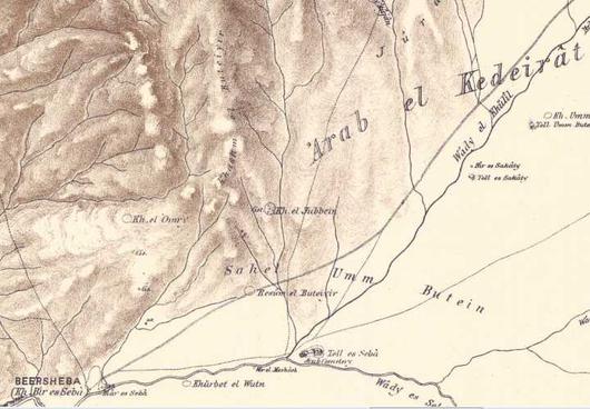
Below, Umm es Seir, a possible Arabic toponym for the Hill Country of Seir (?), SW of Edh Dhariyeh and S of Hebron. Israel was routed in the Hill country from Seir to Hormah by Amalekites and Canaanites (Nu 14:39-45) whereas it is Amorites in Deuteronomy (De 1:44) (PEF 1878 Map sheet 21).
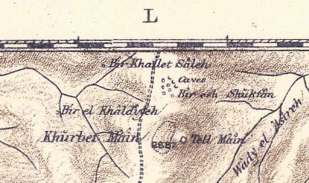
Below, Tell Main is Telem/Telaim (?) where Saul assembled his troops before attacking Amalek in the wilderness of Judah (PEF Map sheet 25). Note: Scholars usually equate Main with Ma'on. Telem/Telaim's location is a puzzle.
Below, Wady Malaki may preserve Amalek (?) in the wilderness of Judah E of Carmel/Kurmul attacked by King Saul (PEF Map 1878 Sheet 21). Wady Malaki is N of Wady Rujm el Khulil.
Below, Wady Rujm el Khulil, biblical Havilah (From the Hebrew root: khool?) E of Carmel/Kurmul and Telem/Tell Main (?) where Saul launched his attack from (?) on Amalek? When Israel attempted to invade the Hill Country of Seir she was routed from Seir to Hormah by Amalekites, Cananites, and Amorites (Nu 14:39-45 and De 1:44):. Could Hormah, pronounced in Hebrew Khormah, be Khasm el Kurm S of Khulil and the Amalekites at Wady Malaki (PEF Map sheet 21)?
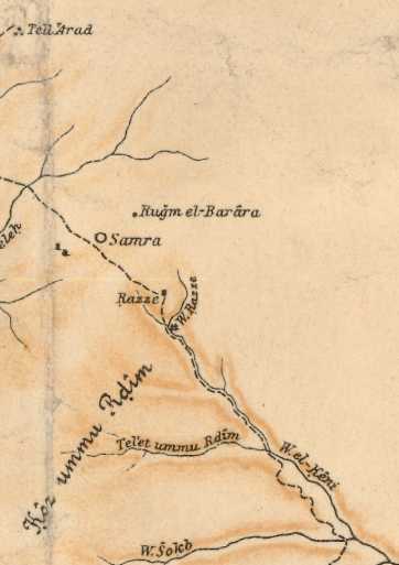
Below, Wadi el Keni may preserve (?) the Kenites who settled in the wilderness of Judah near the negeb of Arad (Jdgs 1:16)? Saul warned the Kenites to separate themselves from the Amalekites to avoid being accidentally slain by Israel (1 Sam 15:6) (Alois Musil. ca. 1907. Karte von Arabia Petraea. Vienna, Austria. Scale: 1:300,000).
Judges 1:16-18 RSV
And the descendants of the Kenite, Moses' father-in-law, went up from the city of palms [a palm tree is called tamar] into the wilderness of Judah, which lies in the Negeb near Arad and they went and settled with the people. And Judah...defeated the Canaanites who inhabitated Zephath and utterly destroyed it. So the name of the city was called Hormah...Judah took Gaza with its territory..."
Of interest is that Musil's Iron Age II settlement of Razze (ca. 1907 Karte von Arabia Petraea) is now rendered as Gazza on more modern maps. Was this the Gaza that was captured by Judah (Judgs 1:17) rather than Gaza on the Philistine coast?
Below, Wady Malaki E of Carmel (identified as Sela-Ham-Mahlekoth?) may preserve Amalek as a toponymn.
Please click here for additional maps of the Negeb showing Arabic Malak as a possible toponym for Amalek.
The "linch-pins" for identifying Saul's defeat of Amalek from Havilah to Shur are drawn from several clues:
(1) The Kenites among the Amalekites in the wilderness of Judah near Arad.
(2) The wilderness of Judah being associated with the area between Carmel and the Dead Sea.
(3) The southern limit of the wilderness of Judah being Arad's Negeb where the Kenites and Amalekites are.
(4) Wady el Keni SE of Arad possibly preserving the Kenites of Arad's Negeb.
(5) Shur (shuwr) possibly being ez Zuweirah by Wady el Keni, the S terminus of the Wilderness of Judah?
(6) Havilah as the Hebrew root khool being Wady Rujm el Khulil (PEF 1878 Map sheet 21)
(7) Amalek being Wadi Malaki N of Khulil (Havilah/Khulil is crossed first to begin the assault on Amalek at Malak
"ALTERNATELY":
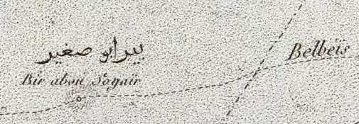
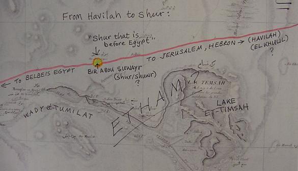
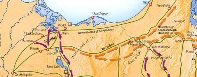
Saul's rout of Amalek "from Havilah to Shur" might be (?) along the Great Caravan Trade Route from Jerusalem via Hebron, Beersheba, Khalasa, and Muweilah to Wadi et-Tumilat (Etham?), Lake et-Timsah (Etham?) and Bir Abu Suwayr (Shur, Hebrew: shuwr).
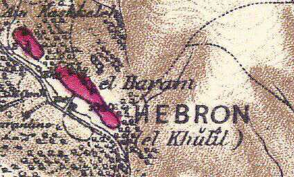
Havilah on this trade route might be Hebron and/or Wadi el-Khulil. How so?
In Arabic Hebron is called el-Khulil "the friend of God" an epithet alluding to Abraham as being "God's friend." The below Palestine Exploration Fund Map of 1878 (scale of 1:63,000) shows Hebron as el-Khulil and the general region as Khulil (later maps however prefer the spelling Khalil instead of the 1878 Khulil). Maps show that the Great Trade Route between Hebron and Beersheba, headed for Egypt, parallels Wadi el-Khulil whose headwaters apparently begin at Hebron/Khulil. In this scenario "Havilah to Shur" would mean that portion of the Darb es Shur (Arabic: "Way to Shur") from Khulil/Hebron and Wadi el-Khulil (Havilah?) to Shur (Bir Abu Suwayr)?
If el-Khulil (Hebron) preserves the Hebrew root Chuwl/Khool/Kheel of Havilah (?) then Saul perhaps (?) chased Amalek from Hebron to Bir Abu Suwayr (Hebrew Shur/shuwr) on the Great Trade Route from Jerusalem to Bilbeis, Egypt. That is to say Shuwr/Shur is _not_ a "wall" its the "well" of Bir Abu Suwayr on this trade route lying on the N side of Wadi
et-Tumilat just W of Lake et-Timsah.
Below, Bir Abou Soyair, modern map's (1970s) Abu Suwayr, on the great caravan route from Jerusalem, Hebron, Beersheba, Khalasa, and Muweilah to Belbeis in the Egyptian Delta (C. L. F. Panckoucke. Paris. 1:100,000. 1826. Flle 31 Suez Canal), my proposal for "Shur that is before Egypt."
Below, same map, panorama view, Bir Abou Soyair/Abu Suwayr is on the N side of Wadi et-Tumilat and NW of Bahr et-Timsah (Lake Timsah). Perhaps Etham is preserved in Wadi et-Tumilat and Bahr et-Timsah? The wilderness of Shur is an alternate name for the wilderness of Etham in the Exodus accounts (Ex 15:22; Nu 33:8). Herodotus was told by Egypt's priests that land watered by the Nile was Egypt. In antiquity Wadi et-Tumilat received the Nile's waters which filled Lake et-Timsah. The Bible states that Israel camped at Etham at the "edge of the wilderness" (Ex 13:20; Nu 33:6) which suggests for me Etham is part of Egypt and it is Wadi et-Tumilat and Bahr et-Timsah (et-Tum and et-Tim possibly preserving Etham?). Once Etham is left, Egypt is left, and Israel is now in the wilderness of Etham/Shur headed for Marah whose waters were bitter, possibly (?) the two Bitter Lakes S of Etham/Et-Timsah called in Arabic Buheirat el Murrat or "bitter." Thence to Elim's 12 springs, the 12 artesian springs of Ayun Musa, "the springs of Moses," and its 70 palm trees E of the port of Suez.
Below, the Bible's "Way to Shur," (Ge 16:7) Arabic: Darb es Shur, the Great Caravan Route from Jerusalem via Hebron, Beersheba, Khalasa and Muweilah to Egypt, passing the N side of Bahr et-Timsah (Lake et-Timsah) and intersecting with Bir Abu Suwayr/Bir Abou Soyair (my Shur that is before Egypt) to the N of Wady et-Tumilat. If Havilah is el Khulil (Hebron) then Saul chased the Amalekites from Khulil (Hebrew: Chuwl/Khool being the root of Havilah/Khavilah) all the way to Egypt (which in my opinion is highly unlikely, this is probably just gross exaggeration or hyperbole).
Below, Bir Abou Soyair (1826) is rendered (1970s) Abu Suwayr and is the site of a military air base (white circle). For me the Hebrew rendering of Shur as Shuwr (Strong 7793 Hebrew & Chaldee Dictionary) resembles somewhat Suwayr.
Update of 15 May 2011:
It appears to me that the Hebrews may at times have misunderstood, misspelled, and mispronounced foreign words, perhaps they "heard" the foreign pronunciation incorrectly?
For example the city of Erech (Ge 10:10) in Mesopotamia in Akkadian (Babylonian) is Uruk. Ararat (Ge 8:4) in Assyrian was Urartu. Sumerian edin (meaning "a back," the uncultivated land "backing" or surrounding the gods' city-gardens in Sumer) became Genesis 'eden ("pleasure" or "delight" Ge 2:8) apparently via homophone/homonym confusion. Hazarmaveth, "village of death" (Ge 10:26), is actually wady Hadhramaut in the Yemen, and Bishah became the Pishon?
English rendered Havilah (Ge 10:28), Hebrew Khaveelah, _if_ derived from khool or kheel (Strong #2341), might be Wady Kuhayl in the Jauf region with its 200 gold adits. The great caravan trade route between Jerusalem and Marib passes near Kuhayl and it continues northward crossing Wady Bishah which may have been rendered by the Jews as the Pishon River which "encompasses" Havilah (You can't can't get to Kuhayl and its gold fields from Jerusalem by caravan without crossing first Wady Bishah (the Pishon?).
Sauer's 1996 proposal that Havilah is Mahd edh-Dhahab was based on this site being the only confirmed gold deposit in the 1990s. After Sauer's 1999 death the 200 gold adits of Wady Kuhayl were discovered in 2000 and perhaps Havilah's gold found at last if I am right in proposing Wady Kuhayl might be Havilah (derived from the Hebrew root: khool, kheel).
If my proposal that "Havilah to Shur" (1 Sam 15:4-10) is Khulil (Hebron and Wady Khulil) to Bir abu Suwayr (Shur), then we have a "second example" of two locations bearing the name Havilah/Khavilah (khool, kheel) on a great caravan trade route: (1) The caravan route from Jerusalem to Marib via Bishah/Pishon and Kuhyal/Khavilah and (2) the caravan route from Jerusalem via Khulil (Khool, Kheel, Khavilah, Havilah: Hebron) to Bir abu Suwayr (Shur?) on the way to Egypt and Belbeis via the Darb es-Shur, "the way to Shur."
Havilah's being a brother of Ophir (Ge 10:29) probably preserves the Khaulan tribal confederation in the Yemen area (The good gold of Ophir being perhaps the Jauf where lies Kuhayl's 200 gold adits?).
A Google search turned up a listing of semi-precious stones found in the Yemen: carnelian, sky agate, honey agate, opal, gasber, flourite and onyx. Note that Sauer (below) understood onyx was associated with Havliah. Onyx is found in the Yemen. Perhaps these represent the precious stones associated with the lands of Havilah and Sheba?
(cf. Yemen Geological Survey & Mineral Resources Board. Yemen Geological Museum. "Local semi-precious stones found in the Yemen.")
Below, a map showing Yemeni Rock Quarries for "Building and Ornamental Stone." Please click here for an "interactive version of the below map which allows one to scroll through the various regions of the Yemen.
Below, Wadi el-Khulil (1861) draining south from el-Khulil (Hebron) to Beersheba is paralleled on its north side by the Great Caravan Trade Route from Jerusalem to Wadi et-Tumilat, Egypt and Bir Abu Suwayr, my Shur, via Hebron, Beersheba and Muweilah ("Palestine or the Holy Land." The Royal Atlas of Modern Geography. London & Edinburgh. William Blackwood & Sons. 1861). Was Saul's rout of Amalek "from Havilah to Shur" from that portion of the Great Trade Route near Wadi el-Khulil to Shur/Suwayr (the Great Caravan Trade Route being alluded to as "what" Amalek was fleeing upon to get to Egypt)?
Below, a map (1878) showing the Great Caravan Trade Route paralleling Wady el-Khulil (Havilah?) near Beersheba.