The Border of Joseph and Benjamin Identified (Joshua 16:1-3)
12 April 2004 Update
For Christians visiting this website my most important article is: The Reception of God's Holy Spirit: How the Hebrew Prophets _contradict_ Christianity's Teachings. Please click here.
Joshua 16:1-3 RSV
"The allotment of the descendants of Joseph went from the Jordan by Jericho, east of the waters of Jericho, into the wilderness, going up from Jericho into the hill country to Bethel; then going from Bethel to Luz, it passes along to Ataroth, the territory of the Archites; then it goes down westward to the territory of the Japh'letites, as far as the territory of Lower Beth-horon, then to Gezer, and it ends at the sea."
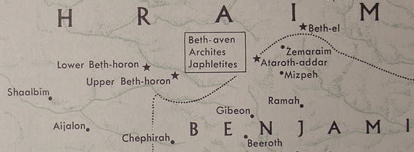
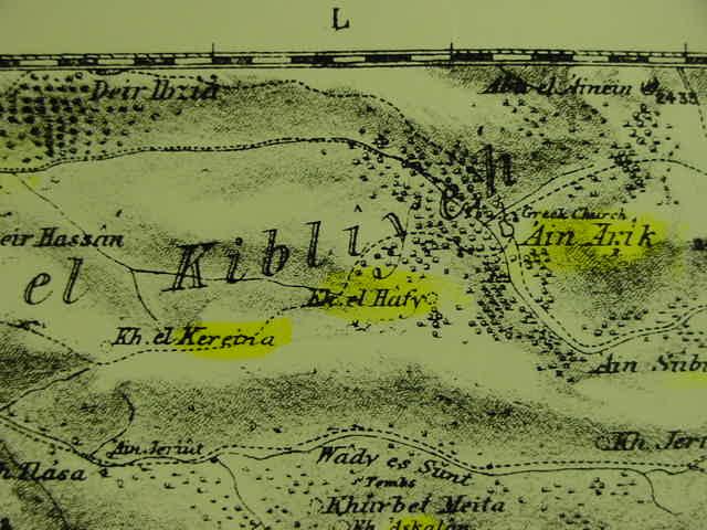
The "below" location of Archites and Japh'letites are unknown in all editions, 1968-1993, of Yohanan Aharoni and Michael Avi-Yonah's Bible Atlas. The dotted line represents "a general" border between the tribes of Joseph and Benjamin due to these sites' location not being known.
(cf. Yohanan Aharoni, Michael Avi-Yonah, Anson F. Rainey, and Ze`ev Safarai. The Macmillan Bible Atlas. New York. 1993. ISBN 0-02-500605-3, cf. Map No. 73, p.62)
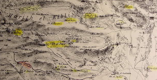
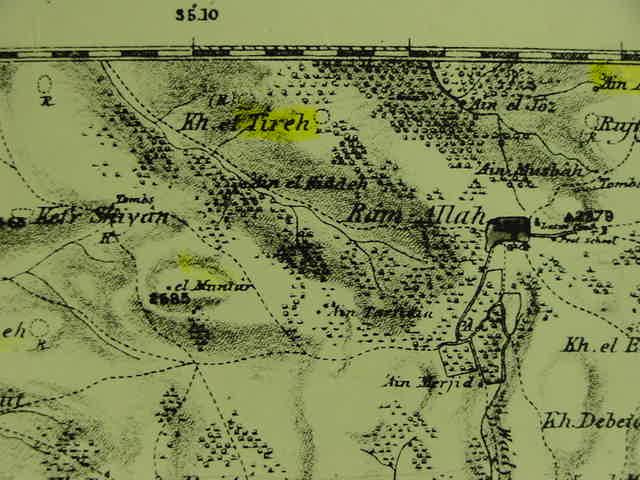
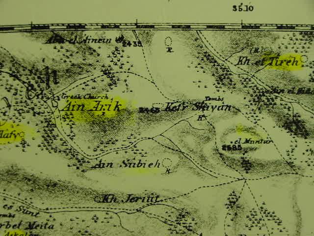
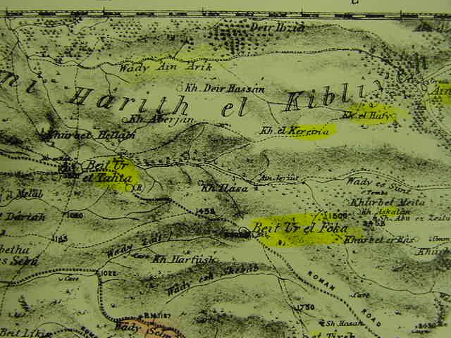
Mattfeld's site Proposals: Ataroth is Khirbet et-Tireh, the Archites or Hebrew: Arki is Ain Arik, west of et-Tireh, the Japh'letites are Khirbet el Hafy, Lower Beth-Horon is Beit `Ur et-Tahta.
(cf. The Palestine Exploration Fund Map, 1878, Sheet XVII, Grid K-M/S)
Note: Aharoni and Avi-Yonah make Joseph's southern border, a dotted line, pass to the south of Lower and Upper Beth-Horon, whereas my proposal is that the border lies to the north of both Beth-Horons. All these sites lie near a track extending northeastwards from Lower Beth-Horon and ending at Ram Allah. The sites, in order, from the viewer's left, are- Beit et-Tahta (Lower Beth-Horn), Khirbet el Kereina, Khirbet el Hafy, Ain Arik, Kefr Shiyan, Khirbet et-Tireh, and Ram Allah (Beitin/Bethel appears ENE of Ram Allah on PEF Map XIV).
Aharoni and Avi-Yonah were unable in their highly regarded Bible Atlas produced in 1968, and since re-printed numerous times through 1993, to suggest sites for the Archites and Japhletites who formed part of the southern border for the Israelite tribe of Joseph in Joshua 16:2-3 (cf. Map No. 73, p.53, Yohanon Aharoni and Michael Avi-Yonah, Editors. The Macmillan Bible Atlas. N.Y. [1968]. 1977. ISBN 0-02-500590-1. These sites eluded the 1993 edition as well. cf. map No. 73. p. 62. ISBN 0-02-500605-3).
Professor Kallai's attempt to pinpoint the location of Ataroth-adar, the Archites and Jahletites was also unsuccessful.
Kallai:
"The locations of Upper and Lower Beth-horon are universally accepted, but it is impossible to localize with the required exactitude either Ataroth-adar or the territories of the Archites and Japhletites."
(p.131. "Benjamin's Allotment." Zecharia Kallai. Historical Geography of the Bible, The Tribal Territories of Israel. Jerusalem-Leiden. The Magness Press. Hebrew University. E.J. Brill. 1986)
After consulting various recensions of Joshua 16:1-3, I offer some proposals for these sites which have eluded scholars for some 2,000 years.
The following proposals are based upon the similarity of names preserved in Arabic of sites to the west of Beitin, which is today identified by most scholars with Bethel. I am using the Palestine Exploration Fund Map, London, 1878, scale: 1:60,000, sheet Nos. XIV and XVII for the site proposals. It goes without saying that confirmation of these proposals must rest in the final analysis, upon archaeological surveys of this area confirming that these "proposed sites" do indeed possess Iron Age deposits, or at the very least, that a nearby site has the deposit, allowing for a "shift of names" if later replaced by a newer settlement.
The Recenscions (English Translations for the most part):
(RSV):
"...going from BETHEL TO LUZ, it passes along to Ataroth, the territory of the Archites; then it goes down westward to the territory of the JAPHLETITES, as far as the territory of Lower Beth Horon...."
(The Peshitta -Aramaic- English translation by George M. Lamsa):
"...from the Jordan by Jericho to the waters of Jericho on the east, into the wilderness that goes up from Jericho to mount Bethel and goes out from BETHEL TO LUZ and then passes along the border of Ebra and Ataroth, and goes down westward to the border of PALTA, as far as the border of Beth-Hauran the lower...."
The New Jerusalem Bible (1990, Catholic):
"...FROM BETHEL IT WENT TO LUZ, and on towards the frontier of the Archites at Ataroth; then passed downwards and westwards to the frontier of the JAPHELITES as far as the border of Lower Beth-Horon..."
The LXX (The Greek Septuaginta):
"...to BAETHEL LUZA. And they will go out to Baethel, and will proceed to the borders of Archatarothi. And they will go across to the sea to the borders of APTALIM, as far as the borders of Baeth-horon the lower..."
The Vulgate (Latin):
"...quae ascendit de Hiericho ad montana Bethel et egreditur de BETHEL LUZAM transitque terminum Archiatharoth et descendit ad occidentem iuxtra terminum IEFLETHI usque ad terminos Bethoron inferioris..."