Sumerian Dilmun is Umm Daleimin by Qurnah?
Please click here for Dilmun possibly being Umm Daleimin by Qurnah on the Shatt al Arab River in Iraq
20 March 2005
Revisions and Updates through 28 July 2010
I had in an earlier article suggested that Qurnah might be Dilmun but, in this article I argue that it might be Tell el-Lahm. Why Tell el-Lahm? It has the archaeological debris required of the Sumerian and Neo-Assyrian/Neo-Babylonian periods, whereas, as far as I know, nothing exists of these eras at Qurnah. Tell el-Lahm also "aligns" geographically with a statement made by the Neo-Assyrian monarch Sennacherib, who in 689 B.C. boasted that a destroyed Babylon's dust was dumped by his soldiers into the Euphrates which carried it to "the sea" where the Dilmunites saw the darkended waters and were terrified. There is, however, a "problem" Tell al-Lahm is dated circa 3000 or 2900 B.C., if it is Dilmun, it should date 3200-3100 B.C. when this name first appears in texts at Uruk in Uruk IV dated strata.
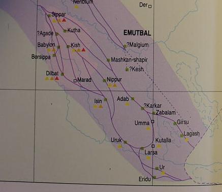
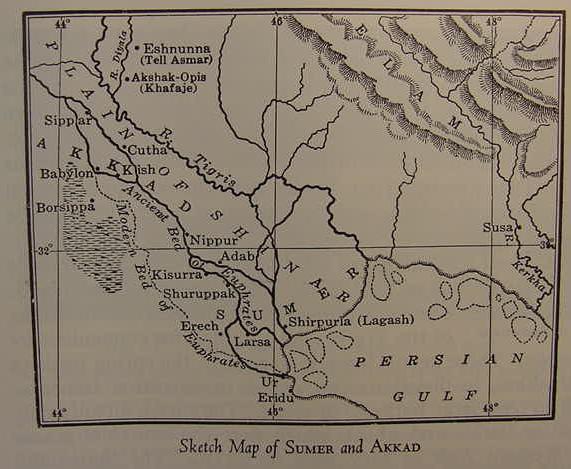
Below a map of ancient Sumer circa 1879 B.C..showing -in dark purple lines- the traces of "possible" ancient river courses branching off the Euphrates. The blue line represents the "modern course" of the Euphrates. (cf. p. 109. Micheal Roaf. Cultural Atlas of Mesopotamia and the Ancient Near East. New York. Facts on File. 1990. ISBN 0-8160-2218-6)
From the Epic of Gilgamesh we learn that Utnapishtim is settled in Dilmun at the mouth of the rivers:
"Henceforth Utnapishtim and his wife shall be like unto us gods.
Utnapishtim shall reside far away, at THE MOUTH OF THE RIVERS!’
Thus they took me and made me reside far away,
At the MOUTH OF THE RIVERS."
(p. 71. "The Epic of Gilgamesh." James B. Pritchard. Editor. The Ancient Near East, An Anthology of Texts and Pictures. Princeton, New Jersey. Princeton University Press. 1958. paperback).
I note that the above text does not say at the _MOUTHS_ of the rivers, rather it is at the _MOUTH_ of the rivers.
Many scholars have understood the "rivers" are the Tigris and Euphrates. Today they come together at modern Qurnah to form the Shatt al-Arab which empties into the Persian Gulf and some present day Arab traditions locate the Garden of Eden at Qurnah accordingly.
From my research on the four rivers of Eden, I had concluded that the Euphrates had in antiquity subdivided into as many as four streams as it crossed the floodplain of Lower Mesopotamia.
In antiquity (3rd millennium B.C.) Eridu was described as lying on "the edge of the sea." Professor D.T. Potts has noted that cuneiform texts call marshland at times a "sea." The texts about the god of Eridu Enki or Ea speak of marshes about his shrine, the present tell or mound called Abu Shahrein. The "sea" was apparently the sebkha just east of Tell Abu Shahrein. This sebkah in the rainy season fills with freshwater discharged by wadies that collect rain water. Like Eridu the sebkah lies in a basin. As the sebkah fills up it becomes a like a "sea" in fact it is approximately the size of the Sea of Galilee in Israel. But by late summer this "freshwater-sea" dries up. So Eridu's "sea" was the sebkah, not the Persian Gulf. Please click here for satellite images of Eridu's freshwater "sea" (Sumerian abzu, Akkadian apsu) the sebkha.
Crawford understands that the Tigris flowed through Adab, Umma and Larsa. I note that Roaf's below map shows Crawford's Tigris flowing through these sites. What is most interesting is that this map shows that Crawford's Tigris after leaving Larsa "MERGES" with the Euphrates just west of Ur. The Euphrates then enters the "sea" near and east of Ur and Eridu.
Crawford, explaining that the Tigris in antiquity was "nearer the Euphrates" and only later migrated eastwards away from the Euphrates in the 2nd millennium B.C.:
"...the Tigris lay slightly to the east of it, flowing through Adab, Umma and Larsa. The latter river was not edged eastwards into its modern bed until after the Kassite period in the later second millennium (Steinkeller 2001). The westward movement of the Euphrates can be traced on the ground, and by the progressive abandonment of ancient sites, such as the old religious capital of Nippur, which were founded on the old course of the river. (p. 9. Harriet Crawford. Sumer and the Sumerians. Cambridge, England. The Cambridge University Press. 1991, 2004)
I note that the Epic of Gilgamesh has Utnapishtim (the Mesopotamian Noah) stating that after the Flood he is settled by the gods in kur Dilmun which lies "at the mouth of the rivers." Most scholars assume that "the mouth of the rivers" is referring to the Tigris and Euphrates rivers, the two principal streams of Mesopotamia. Kur can mean "land," "region," "mountain," and "underworld," so Kur Dilmun could mean the "land" or "region" of Dilmun, and _not_ necessarily "mount" Dilmun.
Perhaps Utnapishtim's statement that "Dilmun lies at the MOUTH of the rivers" is referring to the MOUTH of the MERGED Tigris and Euphrates rivers, the Tigris having merged with the Euphrates just west of Ur after leaving Larsa, and thus Dilmun lies just east of Ur and Eridu where the Euphrates' mouth in antiquity entered "the sea," the marshlands east of Ur. Today (the 21st century A.D.) the Tigris and Euphrates meet at Qurnah, where some Arab traditions locate the Garden of Eden, but in Antiquity, the 3rd-2nd millenniums B.C., the mouth of the combined/merged Tigris/Euphrates was _not_ at Qurnah, but near Ur. All this is to say that Professor Kramer WAS RIGHT, Dilmun lies east of Sumer and Bibby and Potts are wrong in identifying Dilmun with the islands of Failaka and Bahrain in the Persian Gulf which are due south of Sumer. A number of scholars have suggested that Dilmun may be a Sumerian prototype for Genesis' Garden of Eden and I agree, but it is only one of several pre-biblical prototypes behind Genesis' mythical Garden Of Eden.
Below, a map showing the Euphrates (as purple lines) subdivided into numerous channels or streams ca. 1792-1700 B.C. Note that the Tigris flowing through Adab, Umma and Larsa _according to Crawford_ merges with the Euphrates after leaving Larsa, just west of Ur. The merged or combined Tigris-Euphrates flows toward Ur and Eridu as one stream. Then break into two streams then reunite and enter the marshland (called Mat Tamti "the Sea Land") as one river mouth, perhaps Utnapishtim's "MOUTH OF THE RIVERS" where lies Dilmun (cf. p. 120. Map titled: "Hammurabi's Kingdom [in purple]." Michael Roaf. Cultural Atlas of Mesopotamia and the Ancient Near East. New York. Facts on File. 1990. ISBN 0-8160-2218-6). Update of 16 March 2009: The below map "errs": Eridu is located in a great basin, at least twenty feet below the alluvial plain that Ur is upon. Streams do _not_ ascend out of basins, so the below map is _wrong_ in showing the Euphrates leaving Eridu's vicinity and heading east to reunite with the Euphrates channel from Ur. The Euphrates actually ended at Eridu's sebkah which is also in the basin. For satellite images of Eridu and its sebkah and the basin they are in please click here.
Pinches (1908) translated an inscription about Eridu describing it as lying "between the rivers" which he thought might allude to the Tigris and Euphrates debouching into the sea near Eridu in antiquity. He also noted a similar phrase in regards to Dilmun, a place located "at the mouths of the rivers." According to Crawford the Tigris flowed through Adab, Umma and Larsa, and the maps show that Crawford's Tigris merges with the Euphrates after leaving Larsa, just west of Ur, perhaps the enigmatic "mouth of the rivers" refers to the many river courses branching off the Euphrates (including Crawford's Tigris) entering "the sea" or marshlands west of Ur and Eridu?
According to the late Professor Speiser, the "garden of Eden" was somewhere near the head of the Persian Gulf. He thought "the land of Dilmun" might be a prototype of the garden. He noted that Dilmun was located "at the mouth of the rivers" Akkadian/Babylonian _pi narate_, and some scholars assume that "the rivers" are the Tigris and Euphrates.
Speiser:
"Near the head of the Persian Gulf lay the celebrated Dilmun...Paradise...The same general region also bore the name of pi narate, "the mouth of the rivers" (sometimes reduced to "the mouth of the two rivers")." (p. 179. E. A. Speiser. "The Rivers of Paradise." pp. 175-182. Richard S. Hess & David Toshio Tsumura. Editors. "I studied inscriptions from before the Flood." Ancient Near Eastern, Literary, and Linguistic Approaches to Genesis 1-11. Winona Lake, Indiana. Eisenbrauns. 1994)
Speiser continues:
"The biblical text itself contains two semantic trailmarkers that point unambiguously to the land and lore of Sumer. One is the geographic term Eden, which hardly can be separated from Sumerian edin "plain." The other is the `ed of Genesis 2:6, the term for the groundwater that first irrigated the land. Whether one derives the word, with W. F. Albright, from id "river," or from Sumerian a.de.a (Akkadian edu) "groundflow," as I have recently advocated, its origin would be Sumerian in any case." (p. 179. E. A. Speiser. "The Rivers of Paradise." pp. 175-182. Richard S. Hess & David Toshio Tsumura. Editors. "I studied inscriptions from before the Flood." Ancient Near Eastern, Literary, and Linguistic Approaches to Genesis 1-11. Winona Lake, Indiana. Eisenbrauns. 1994; citing an article from 1958)
Langdon (1931) thought Dilmun was an island (I don't believe it is an island) which, originally in the Sumerian version lay near the mouths of the Tigris and Euphrates rivers:
"Here again there seems to be a confusion of sources, for Gilgamesh's journey with the boatman across the western sea to find Utnapishtim as related in tablets nine and ten cannot be reconciled with the location of the land of the blessed at the mouth of the rivers in tablet eleven, or the flood story. The 'mouth of the rivers' is surely taken from the Old Sumerian legend in which Ziusudra was translated to Dilmun. Obviously some island at the mouth of the Tigris and Euphrates is meant here." (pp. 223, 224. Stephen Herbert Langdon. The Mythology of All Races, Semitic. Vol. 5. Boston. Archaeological Institute of America. Marshall Jones Company. 1931)
Potts citing the Assyrian King Sennacherib's claims about his destruction of Babylon for repeated rebellions circa 689 B.C.:
"After I had destroyed Babylon...I removed its ground and it carried to the Euphrates and on to the sea. Its dust was carried to Dilmun. The Dilmunites saw it, and terror of the splendor of Asshur fell upon them." (p. 339. Vol. 1. D. T. Potts. The Arabian Gulf in Antiquity. Oxford. The Clarendon Press. 1990)
Potts in referring to the above quotation noted (Emphasis mine):
"R. Campbell Thompson read it as _proof_ Dilmun was NOT Bahrein, but rather A LOCALE NEAR THE MOUTH OF THE EUPHRATES. J. F. Salles identified the muddy waters near the island of Failaka." (p. 339. Vol. 1. D. T. Potts. The Arabian Gulf in Antiquity. Oxford. The Clarendon Press. 1990)
According to Mesopotamian myths, the god of freshwaters, Enki, who dwells in the freshwater abyss at Eridu, is the "single source" of all the world's rivers, in some hymns he is portayed lifting his penis and ejaculating his sperm into the Tigris and Euphrates, filling them with clear sparkling freshwater. He is also portrayed iconographically on cylinder seals with two streams of water with fish in them erupting from his shoulders, showing again, he is the "single source" of these two rivers NOT the far-off mountains of Armenia where these two streams begin according to modern maps.
I supect this Eridu Apsu/Abzu motif became in Genesis, ONE SOURCE (Hebrew: ed) for four rivers, the Tigris, Euphrates, Pishon and Gihon. In Mesopotamian myth, at first there was only sea, then suddenly a freshwater stream appeared, erupting from the sea's surface, land formed about this freshwater source and the God Enki built his shrine here at Eridu. So, the imaginary fountain or spring for the Euphrates and Tigris is Enki who dwells at Eridu in the midst/depths of the Apsu/Abzu freshwater ocean under the earth. That is to say, I understand that Eridu's imaginary "Apsu spring or fountain" lies behind Genesis' notion that one fountain provides water for four rivers.
Lieck has identified the "physical phenomenon" that apparently caused ancient man to associate Enki's abzu/apsu with Eridu. This site is located upon a small hillock which in turn lies in a great depression in the earth. This depression in the rainy season fills with rain water runoff from wadies ringing the basin Eridu and the sebkha lie in. Later in the summer this sebkha freshwater lake disappears via evaporation and absorption into the parched earth of the basin. Arabs can dig down 6 feet into the basin's bottom and tablewater will rise and fill the pits. It is most probably this natural geological phenomenon that was thought to be Enki sending up from the depths of the apsu under the earth, his freshwaters! Please click here for Leick's discription of the "Eridu abzu" or "apsu" phenomenon and scroll down to the update of 13 April 2005 for the details.
Beek on the swamps or marshes being called "the sea":
"Shulgi, the son of Ur-Nammu, devoted special care to the city of Eridu, which lay on the sea coast. Perhaps people considered the extensive area of swamps...as forming part of the sea?" (p. 10. Martin A. Beek. Atlas of Mesopotamia. London. Thomas Nelson & Sons. 1962)
Roux quotes some verses which suggest _to me_ that the marshlands were indeed understood in antiquity to be a part of the sea. Perhaps the "Bitter River" is an allusion to the modern day Shatt al-Arab (meaning "border of the Arabs"), which receives each day salty or bitter waters from the high tides of the Persian Gulf? Thus Elam on the _other side_ of the "Bitter River" is the Susa area east of the 100 mile long Shatt al-Arab and its adjoining swamplands? Today the Tigris and Euphrates meet at Qurnah to form the northernmost part of the Shatt al-Arab but in antiquity, the 3rd millennium B.C., the "merged" Tigris and Euphrates rivers' mouth was at Eridu and Ur _not_ Qurnah.
Roux citing Assyrian texts:
"...fled like a bird to the (Elamite) swampland of Nagite, which is in the midst of the sea." (p. 321. George Roux. Ancient Iraq. Penguin Books.1992. 3rd edition. paperback)
"...then in 694 B.C., under the pretext of capturing the Elamite cities 'on the other side of the Bitter River', whither the people of Bit-Iakin had scattered before the mighty weapon of Asshur..." (p. 321. George Roux. Ancient Iraq. Penguin Books. 1992. 3rd edition. paperback)
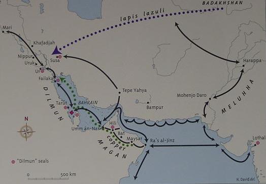
A number of scholars understand that the "land of Dilmun" (believed to be a type of Sumerian "Paradise" and thus a possible pre-biblical prototype of Genesis' Garden in Eden) mentioned in Mesopotamian documents from the 4th-1st millenniums B.C. is the island of Bahrein (Bahrain) off the Arabian coast in the Persian Gulf. I understand that the Mesopotamian inscriptions describing Dilmun (as well as the lands of Melukhkha and Magan/Makan), have been misunderstood by scholars, and that in fact, these locations probably lie in or were near the marshlands of Lower Mesopotamia, between Sumer and Elam.
Dilmun appears in Lower Mesopotamian texts (Sumer) from as early as 3300 B.C to as late as the time of Nebuchadrezzar circa the 6th century B.C. Dilmun appears in texts from Uruk dated circa 3300 B.C. from Lagash circa 2500 B.C., and from Tello ca. 2365 B.C. yet no settlement exists on Bahrain which has been identified with Dilmun before circa 2200 B.C. That is to say, despite the appearance of Dilmun in Mesopotamian texts from circa 3300-2365 B.C. the first settlement on Bahrain is circa 2200 B.C. while Failaka was not settled until after 2000 B.C., in other words for nearly a thousand years, 3300-2300 B.C., Sumer traded with a "phantom" Dilmun which _did not exist_ on the islands of Bahrain and Failaka in the Arabian Gulf.
Professor Crawford on the archaeological absence of a major settlement for Dilmun on Bahrain:
"It is a useful excercise to compare the picture presented by the textual evidence with that derived from archaeology of the Arabian Gulf. The fairly straightforward picture of gradually intensifying contacts between Mesopotamia and Dilmun from the late fourth millennium onwards, briefly interrupted by closer ties between Mesopotamia and Magan in the Ur III period is not matched by the material remains...we have already seen that there is unambiguous evidence from the economic texts of the later fourth millennium for contact between southern Mesopotamia and Dilmun, the islands of Bahrain seem to have been virtually uninhabitated. This period in Mesopotamia is represented by the Uruk and Jemdat Nasr periods, but pottery of this type is virtually absent from Bahrain (Larsen 1983b:77) and the evidence for any contact with Mesopotamia is very thin...it would seem that Bahrain was only inhabitated by small groups of fishermen or farmers during this period. It can hardly have been the centre of a trading network.
The islands only seem to have been extensively inhabitated in the second half of the third millennium, despite the fact that the texts suggest steadily increasing contacts from about 2600 B.C. The final anomaly is provided by the fact that, in the late third millennium, when the tablets only refer to trade with Magan, Bahrain appears to be more prosperous and in closer contact with Mesopotamia than Oman (Magan) was."
(p. 4. "The Setting." Harriet Crawford. Dilmun and its Gulf Neighbours. Cambridge, the United Kingdom. Cambridge University Press. 1998)
The following quotations and observations are from Traces of Paradise, the Archaeology of Dilmun, a paperback catalogue and guide made in 2000 to accompany an exhibition of objects from Bahrain and area.
"...Dilmun, whose name appears in the 4th millennium onwards in the archaic texts of Uruk, around 3300 B.C."
(p. 25. Serge Cleuziou. "Dilmun: Origins and Early Development." in Harriet Crawford & Michael Rice, editors. Traces of Paradise, the Archaeology of Bahrain, 2500 B.C -300 A.D. London. Published by the Dilmun Committe for an exhibit from the Bahrain National Museum. Printed June 2000)
Mention is made of Ur-Nanshe, king of Lagash, who noted trade with Dilmun. He is dated circa 2500 B.C.
(p.16. Pierre Lombard & Khaled Alsendi. "Bahrain: Two Seas, One Civilisation." in Traces of Paradise)
A pre-cuneiform tablet from Uruk is illustrated, mentioning Dilmun and it is dated to the Uruk III Period, circa 3100-3000 B.C.
A Mesopotamian hymn describing Dilmun mentions a river. There is no evidence of a river on the islands of Bahrain or Failaka:
"No one crossed the river shouting..." (p. 30. Beatrice Andre-Salvini. "The land where the sun rises..." The Representation of Dilmun in Sumerian Literature." in Traces of Paradise)
"The largest archaeological site in Bahrain is the tell of Qal'at al-Bahrain, on the north coast of the main island...The earliest remains of human occupation found at Qal'at al-Bahrain date back to circa 2200 B.C...This small settlement is the only one from this period in Bahrain and, indeed, in all of eastern Arabia. The finds show subsistence at that time already relied on a fully developed oasis agriculture with palm trees and cereal cultivation in the nearby fields, supplemented by herding of cattle, sheep and goats and by fishing." (p. 59. Flemming Hojlund."Qal'at al-Bahrain in the Bronze Age." in Traces of Paradise)
"The early Dilmun settlement of Saar is strung out along the eastern slope of a low ridge running parallel to the west coast of Bahrain...The origins of the settlement can therefore be placed around 2300 B.C., the main phase being around 1900 B.C. and perhaps enduring for around 200 years." (p. 63. Flemming Hojlund. "Qal'at al-Bahrain in the Bronze Age." in Traces of Paradise)
"The first written references to Dilmun in the Mesopotamian tablets...date around 3200 B.C. ..." (p. 73. Harriet Crawford. "Bahrain: Warehouse of the Gulf." in Traces of Paradise)
"A trading network of the volume and complexity of that between Mesopotamia and Dilmun requires relatively complex administrative techniques for weighing, pricing and recording the transactions. While we have cuneiform texts from Mesopotamia, as we have seen, there are no comparable documents from Dilmun. If a local writing system existed, it would seem that it used perishable materials like ink and skins which have not survived." (p. 75. Harriet Crawford. "Bahrain: Warehouse of the Gulf." in Traces of Paradise)
A cuneiform tablet from Tello, ancient Girsu, dated circa 2365 B.C. mentions Dilmun (p. 77. Harriet Crawford. "Bahrain: Warehouse of the Gulf." in Traces of Paradise)
Dilmun appears again on another tablet from Tello dated to the Early Dynastic Period, circa 2380-2350 B.C. (p. 78. Harriet Crawford. "Bahrain: Warehouse of the Gulf." in Traces of Paradise)
Speaking of the Barbar temples:
"The temples can be dated to the centuries around 2000 B.C. and are contemporary with the appearance of the stamp seals..." (p. 91. H. Hellmuth Andersen & Flemming Hojlund. "The Barbar Temples." in Traces of Paradise)
"The earliest local seals in Bahrain were manufactured in about 2050 B.C." (p. 101. Poul Kjaerum. "The Hidden Art of Dilmun: the Stamp Seals." in Traces of Paradise)
Bilingual Sumerian/Akkadian clay tablets found at Qal'at al-Bahrain date from circa 1450 B.C. and mention goods. (p. 113. Beatrice Andre-Salvini. "The Cuneiform Tablets of Qal'at al-Bahrain." in Traces of Paradise)
In 1878/1879 an inscribed block was found at Bahrain as part of a mosque that bears an inscription mentioning "the palace of Rimun, the servant of Inzak, of the tribe of Agarum." H. C. Rawlinson after translating the cuneiform inscription suggested that as the god Inzak is associated with Dilmun that perhaps Bahrain was Dilmun (p. 213. Michael Rice. "Britain's Early Contributions to the Archaeology of Bahrain." in Traces of Paradise).
Below, a map (published 2000 A.D.) showing the location of Dilmun, Magan, Meluhha. Dilmun is understood to embrace the eastern coastline of Arabia including the island of Failaka opposite Kuwait to the island of Bahrain (cf. p. 15. Harriet Crawford & Michael Rice, editors. Traces of Paradise, the Archaeology of Bahrain, 2500 B.C -300 A.D. London. Published by the Dilmun Committe for an exhibit from the Bahrain National Museum. Printed June 2000)
Professor Potts on Dilmun:
"Dilmun (region in the 'Lower Sea', originally on the mainland of eastern Saudi Arabia and eventually centred on Bahrain island." (p. 352. "Index." D. T. Potts. Mesopotamian Civilization: The Material Foundations. Ithaca, New York. Cornell University Press. 1997)
Why do scholars embrace the notion Dilmun is _three_ locations (eastern Saudi Arabia, Failaka and Bahrain)? They have a "problem" which refuses to go away. The problem? There is _no_ archaeological evidence to support the theory these places were in existence circa 3300-2300 B.C. to trade with Sumer.
Hojlund put it all very succintly in his observation that _only_ Qal'at al-Bahrain possesses a site of any size worthy of being Dilmun's chief city and it didn't come into existence until circa 2200 B.C. Note his statement that not even on the eastern Arabian mainland are there any sites to compare in size with Qal'at al-Bahrain which he portrays as "small" in size:
"The largest archaeological site in Bahrain is the tell of Qal'at al-Bahrain, on the north coast of the main island. The tell measures 70 meters by 400 meters and rises to a height of circa 8 meters...The tell of Qal'at al-Bahrain was identified as the probable site of the ancient capital of Dilmun in 1954, and from then until 1978 excavations were carried out here by P. V. Glob and Geoffrey Bibby of the Danish archaeological mission, and have been continued since 1977 by Monique Kervran and Pierre Lombard of the French archaeological mission...The earliest remains of human occupation found at Qal'at al-Bahrain date back to circa 2200 B.C...This small settlement is the only one from this period in Bahrain and, indeed, in all of eastern Arabia. The finds show subsistence at that time already relied on a fully developed oasis agriculture with palm trees and cereal cultivation in the nearby fields, supplemented by herding of cattle, sheep and goats and by fishing." (p. 59. Flemming Hojlund."Qal'at al-Bahrain in the Bronze Age." in Traces of Paradise)