Maps of Ancient Lower Mesopotamia's "Sealand" (Akkadian/Babylonian: Mat Tamti) and the land of Dilmun
Please click here for Dilmun possibly being Umm Daleimin by Qurnah on the Shatt al Arab River in Iraq
16 March 2008 (Revisions through 05 September 2010)
This article in a nutshell:
A search of the internet for a map of Ancient Lower Mesopotamia's area called the Sealand or Mat Tamti was without success, so I have decided to post such a map here. My primary interest is in identifying the pre-biblical origins of the mythical biblical Garden of Eden in Mesopotamian myths. I understand one of Eden's precursors is the fabled land of Dilmun said to have been located in "the Sea," which apparently (cf. below) was a _euphemism_ for "the Sealand" or Mat Tamti, thus the reason for maps showing the Sealand in this article.
According to ancient Mesopotamian myths in the beginning all was sea, then in the midst of the sea a freshwater stream emerged and broke through to the sea's surface. Land was gathered about this freshwater conduit and the Sumerian city of Eridug was established by the Sumerian god called Enki. The Akkadians (Babylonians) would call Sumerian Eridug Eridu and Enki Ea, (Ea meaning according to some "house of water"). Enki/Ea was envsioned as not only being the god of freshwaters but also the creator of mankind. He made man to till and tend his garden which possessed fruit trees at Eridu, replacing the Igigi gods who had complained of their grievous toil in caring for his garden. The uncultivated land surrounding Sumer's cities and their gardens of the gods which included fields surrounding the cities was called in Sumerian eden or edin (both spellings appear in the professional literature).
Eridu is described as being "at the shore of the sea" in various hymns. Surprisingly this "sea" is also referred to as a snake marsh and Enki enjoyed punting his boat in this area. Apparently the Sealand or Tamti was the marshlands east of Sumer and west of Elam. The Mesopotamians may have envisioned the marshlands and their lagoons as the original primitive state of the "first land" that had emerged from the sea in their myths.
Beek on the "seacoast" being at Eridu (I note that Sennacherib said that Babylon's dust reached "THE SEA" via the Euphrates river and Dilmun, perhaps Sennacherib's "sea" is Shulgi's "sea," the tamti or Sealand (Shulgi reigned at Ur, 12 miles NW of Eridu, from circa 2094-2047 B.C.)?:
"Shulgi, the son of Ur-Nammu, devoted special care to the city of Eridu, which lay on the sea coast...Perhaps people considered the extensive area of swamps... as forming part of the sea?"
(p. 10. Martin Beek. Atlas of Mesopotamia. London. Thomas Nelson & Sons. 1962)
There are some "surprises" here regarding the Sealand or Tamti. Many maps of Ancient Lower Mesopotamia drawn up by scholars from circa 1881 to 2008 show the Persian Gulf as ending at or near Ur and Eridu based on the ancient texts stating that Eridu was near the "shore of the Sea."
In 1960 Georges Roux visited this area and was able to establish the existence of several ancient tells dating from the 2d millennium B.C. making it quite clear that the Persian Gulf's (Arabian Gulf's) shore was _not_ at Ur or Eridu despite these cities being described in 2d millennium B.C. texts as at the "Sea's shore," the area immediately east of these two Sumerian cities was in fact a region consisting of freshwater lagoons, marshes and _areas of open land_ which could be cultivated. Roux plotted the remains of the Euphrates river winding its way through these marshlands and their lagoons and noted the ancient settlements near this river and traces of their irrigated fields and wells.
Sargon of Akkad (circa 2350-2300 B.C.) boasted of circling the Sealand and conquering Dilmun. I suspect that Dilmun is in the Sealand or marshlands east of Eridu and Ur and it is not the island of Bahrein (or Failaka) in the Persian Gulf (Arabian Gulf) as is understood by most scholars.
From the below verses I draw the conclusion that the "land of the sea" is the Tamti marshlands east of Eridu and Ur and west of Elam, where lie Dilmun, Magan and Meluhha.
"The [la]nd of the sea I seiged three times, I conquered Dilmun.
I went up to great Der...
Whatsoever king who shall arise after me...
Let him siege the [la]nd of the sea three times,
[Let him conquer Dilmun].
Let him go up [to] great Der..."
(p. 165. Sargon of Akkad, 2334-2279 BC. Benjamin R. Foster. From Distant Days, Myths, Tales, and Poetry of Ancient Mesopotamia. Bethseda, Maryland. CDL Press. 1995. ISBN 1-883053-09-9. paperback)
If Shulgi's "Sea" is the Marshlands east of Eridu perhaps the "Sea" associated with Dilmun, Magan and Meluhha is the Sealands?
"They destroyed Gutium and invaded Elam,
They destroyed Elam and arrived at the seacoast,
They killed the people of the (sea) crossing.
They were thrown to [ ],
Dilmun, Magan, Meluhha,
Whatever is in the midst of the sea they killed."
(p. 173. "Legend of Naram-Sin, 2254-2218 B.C." Benjamin R. Foster. From Distant Days, Myths, Tales, and Poetry of Ancient Mesopotamia. Bethseda, Maryland. CDL Press. 1995. ISBN 1-883053-09-9. paperback)
Professor Potts on the term 'sea' being applied by the ancients to marshlands or swamps with their lagoons as well as the open sea of the Persian Gulf and thus it is an error to think Ur and Eridu which are described as near a 'sea,' are implying the Persian Gulf, instead 'the sea' is actually an area of lagoons and marshes:
"The same caveats noted by Waetzoldt must also be applied to the accounts of Sennacherib's campaign against Elam in 696 B.C., according to which 'ships of my warriors reached the swamps at the mouth of the river where the Euphrates carries its waters into the fearful sea'...In all these cases, however, whether Ur and Eridu in the third millennium, or the expedition of Sennacherib against Elam, references to 'the sea' must be treated cautiously. Not only has Waetzoldt shown that, in early sources, the same terms are used for marsh/swamp and open water, but more recently S.W. Cole has demonstrated clearly that a large marsh around the site of Borsippa, southwest of Babylon and far from even the northernmost line of the Gulf, projected by de Morgan or Larsen, was routinely called the 'sea' (Akkadian tamirtu) in texts dating to the Neo-Assyrian, Neo-Babylonian and Achaemenid periods (Cole 1994:81-109). Clearly, therefore, references to 'the sea' are ambiguous and must be examined more closely in conjunction with other types of evidence before they are taken to refer to the open waters of the Gulf itself. Indeed, this point is brought home forcibly by the very designation of southernmost Mesopotamia from the early second millennium B.C. onwards."
(p. 36. "The Progradation of the Tigris-Euphrates Delta." pp. 30-41. D. T. Potts. Mesopotamian Civilization: The Material Foundations. Ithaca, New York. Cornell University Press. 1997)
Potts noted that ancient texts from Nippur reveal the products from the Sealand were cattle, grain and dates:
"In cuneiform sources southernmost Mesopotamia was known as mat tamti(im) (Sumerian KUR.A.AB.BA), the 'Sealand' (Brinkman 1993:6)...a small group of texts from Nippur which mention cattle from the Sealand, K. Kessler has suggested that this region was one of the principal stock-breeding regions of the Kassite state, providing cattle...Grain and dates from the Sealand are also mentioned in Kassite texts from Nippur, suggesting that the area was agriculturally important as well at this time. In the Neo-Assyrian period the Sealand was the home of the important Chaldean tribe, Bit-Jakin, against whom numerous Assyrian monarchs campaigned. In the Neo-Babylonian period the Sealand remained a province of the empire, at least through the reign of Nebuchrezzar II (604-562 B.C.), and it again became one under the Achaemenid king Cambyses (529-522 B.C. (Joannes 1990:177)."
(p. 36. Potts. 1997)
Texts about Enki of Eridu have him blessing various localities near Sumer, one of which is Dilmun. It is interesting to note here what products are blessed by Enki: lagoons filled with fish and dates. A number of scholars understand from texts that Dilmun boats traded copper with Sumer, yet the Enki blessing does not mention any metals or precious stones. Timber is also noted in Sumerian texts being brought in boats coming from Dilmun and Potts has noted timber was a 'marshland' product:
"...texts from Girsu...forty texts concern 'wood newly cut from the marsh woodlands..."
(p. 109. Potts. 1997)
Professor Potts on the Sealand and their ancient settlements, citing the work of various scholars including Georges Roux's discoveries (1960) near the Hor al-Hammar Lagoon, arguing this area was _never_ submerged by the Persian or Arabian Gulf:
"In cuneiform sources southernmost Mesopotamia was known as mat tamti(m) (Sumerian KUR A.AB.BA), the 'Sealand'...While B. Meissner could claim in 1920 that the lack of mounds in this region made it certain that it had been under water (Meissner 1920:4), G. Roux's survey of the Hor al-Hammar (fig. 1.17) showed that this was purely the result of insufficient exploration (Roux 1960:30), for there is in fact a string of mounds 'extending in an almost straight line from Tell Lahm to a point 23 miles north of Basrah' which, Roux suggests 'provides a strong argument against the classical theory according to which the whole of this region was under sea-water from prehistoric times to the dawn of the Christian era' (Roux 1960:30). The existence of sites such as Tells Kirbasi, al-Lahm, Aqram and Abu Salabikh in the area of the modern Hor al-Hammar underscores the fact that, from at least the early second millennium B.C. onwards, this was a populated area which, while it may have been marshy, was certainly not submerged beneath the Gulf. Rising no more than 2 meters above the water line, Tell Kirbasi is today periodically surrounded by water, yet it is difficult to imagine that a site like this was located on an island in the Kassite period, for there is little reason to suppose that if this were the case, Tell Kirbasi or indeed the Sealand generally would have been cited as a source of cattle and cereals. Thus, de Morgan's suggested shoreline in the time of Sennacherib would place under water sites such as Tell al-Lahm which we now know were occupied during the Neo-Assyrian period! The discovery of a cylinder of Nabonidus (555-539 B.C.) at Tell al-Lahm...moreover, confirms that 150 years after Sennacherib's time, the region was most definitely not submerged, and indeed Sanlaville's sea-level curve shows that sea-levels throughout the second millennium B.C. were only marginally higher (less than 1 meter) than they are today, while from the Neo-Assyrian through the latter part of the Parthian era, they were, contrary to de Morgan's belief, significantly lower than modern levels.
That is not to say, however, that the entire area of southernmost Mesopotamia was dry land, or that references to 'the sea' in Sennacherib's account or in texts relating to Ur and Eridu do not refer to some inland body or bodies of water which actually existed...more recently Adams has suggested, 'We may have to deal in in the past, as to a lesser extent we still do today, not with a well-defined shoreline but with a progression of swamps and more and more open, more brackish or saline lagoons' (Adams 1981:16). Nevertheless, this does not necessarily mean that the Hor al-Hammar itself existed when the sites found by Roux were inhabitated. As Roux himself remarked, the existence of relict canals near Tell Abu Salabikh and a well at Tell Aqram suggest that this region was once cultivated, as indeed the Kassite cuneiform sources cited above confirm, and drier than it is today."
(pp. 37-38. Potts.1997)
"Finally, had the Gulf actually reached the area of Ur, Eridu or Tello, one must ask whether these sites could have then existed. W. Nutzel has noted that the tidal pattern in the northern Gulf affects the waters of the Shatt al-Arab in that salt-waters enters it at least as far as Abdul Khasib, circa 10 kilometers east of Basra. The interchange of salt and sweet water would have made irrigation from such water impossible, for none of the staple cereals grown in antiquity would have been able to tolerate water with such a high salt content. Therefore, settlements must always have been situated outside the zone affected by such an interchange. The very existence of sites like Ur, or for that matter, the mounds discussed above in the Hor al-Hammar district, Nutzel argues, precludes the possibility that salt-water was present in close proximity to them (Nutzel 1980:98-9)."
(p. 39. Potts.1997)
Willcocks (1919), a trained irrigation works engineer, objected to notions that the shore of the Persain Gulf had been near Ur and Eridu in antiquity on the basis of cuneiform texts mention the shore of the sea. He was sure the Gulf had _always_ lay south of Basrah (he is refuting Professor A.H. Sayce of Oxford and his 1887 proposal Eridu was on the shore of the Persian Gulf):
"Salt water has never reached the marshes, owing to the delta of the Karun and the Kerkha lying between them and the sea. The effect of the ten-foot tide in the Persian Gulf has been and is communicated to the rivers, and travels up nearly a hundred miles, but no salt water has entered the marshes. To the original writers of these epics, the Deep was a fresh-water deep. The Karun river has played no small part in the formation of the Tigris-Euphrates delta...It has been the main factor in forming the comparatively high-lying land which stretches from Basra eastwards. This tongue of land protects the Tigris-Euphrates swamps from the inroads of sea water, and keeps them fresh. The Basra bar is formed almost entirely of Karun mud. The Tigris and Euphrates mud lies faraway to the west. In ancient times the Karun and Kerkha had but one outlet; but, 500 or 600 years ago, the Kercha left the higher-lying Karun delta, and has been since discharging its waters into the Euphrates and Tigris swamps."
(p. 26. Sir William Willcocks. From the Garden of Eden to the crossing of the Jordan. London. E. & F. N. Spon, Ltd. 1919. 2nd edition. Please click here to access his book digitalized by Google and available on the internet)
Willcocks believed that Apsu and Tiamat (his Tehomat, who both lived in myth, at Eridu) were dieties associated with the Euphrates' annual flooding, he did _not_ associate Tiamat with the salt-water Persian Gulf like many PhD scholars do (he thought Ea of Eridu was pronounced Yeh-hua, who later became the Bible's Jehovah or Yahweh):
"Apsu, the flowing and ebbing but limitable fresh-water lake, appeals to Tehomat, the illimitable and ever-moving flood, to help him overthrow the beneficent works of Maraduch...so opens the Epic of Creation...Yeh-hua...mastered Apsu and the marshes but it was Maraduch, the last born of these gods, who entrapped Tehomat with a network of canals and dykes..."
(pp. 31-32. Willcocks. 1919)
The prophet Ezekiel understood that the cedar trees in the Garden of Eden in the Lebanon mountains drew their water from a subteranean water source called tehom (tehom rendered into English as "the deep" Ez 31:4). I suspect Willcocks is right, Apsu and Tehom, who in myth live at Eridu, are but two manifestations of freshwater. Ab-zu is rendered by Langdon (1931) as nether (zu) sea (ab) and the husband of Tiamat in myths. She seeks to annihilate the gods her chldren who have killed her husband at Eridu. She is killed by Marduk of Babylon, the "son of Ea." Perhaps then, Abzu/Apsu is the freshwater sea "under" the earth (the "nether" world) while Tiamat is this sea in its manifestation of "rising" from the underworld to fill in hollows in the earth such as springs and wells? In some cases rivers arise from mountain springs. So Ezekiel's subterranean tehom is Tiamat "welling-up" or "rising" from under the earth to water the trees in the Garden of Eden? Enki/Ea dwells in the Abzu/Apsu and cylinder seals show two rivers erupting from his shoulders, perhaps an allusion to subterranean waters rising-up or welling-up from under the earth to become rivers?
Willcocks noted three reasons why Sayce thought Eridu lay on the Persian Gulf and refutes each of these reasons:
"The Reverend Professor Sayce is of the opnion that though salt water may not today enter the marshes, it was very different in old times, and that for three reasons. The first is the fact that the Babylonian writers seem to use the same word for the marshes as for the sea; the second is the fact that Eridu was the port of the country and was built on a horn of the sea; and the third is the fact that the first man was believed to have lived at Eridu and fished in the sea, and every day presented a dish of food to his deity. To this I reply that, like their descendants the modern Arabs, these ancient peoples had but one word for perennial river, fresh-water lake, and sea, just as they had but one word for plain and hill when they were out of reach of the flood and consequently desert. This is the key to understanding the history of the Flood as we have already seen...With the geography of the country as it has always been and is today, no salt-water can ever have reached the marshes, since the high-lying delta of the Karun river has lain between the low-lying delta of the Tigris and Euphrates and the sea; and these latter rivers have been forced to cut a passage through the Karun delta in order to reach the Persian Gulf. Far from it having been possible for salt-water to have entered the marshes in the remote past, I can assert that the further we go back the less was there any chance for the sea to have penetrated into the marshes. The less the quantity of water withdrawn from the Tigris, Euphrates, Kerkha and Karun for purposes of irrigation, the more difficult was it for the sea to travel up. In the time of Babylonia's greatest prosperity, when nearly the whole discharge of the Tigris and Euphrates was used up in irrigation, even then salt-water did not reach the marshes, because irrigation of the Karun and Kerkha was undeveloped, and the Babylonians moreover had their reservoirs. It is possible that when, in the future, all the water of the four rivers will be withdrawn from them for irrigation, sea water may travel up the marshes...in the remote times of the Epic of Creation, the marshes were not only fresh as they are today, but they probably covered three and a half million acres, instead of covering two and three-quarter million acres as they do today. The fact that Eridu was the port of the country in no way affects the question. Basra is the port today, and is removed 60 miles from the sea, and is visited by ocean-going steamers drawing from 16 to 18 feet of water, while the water in front of it is fresh and is utilised for irrigating millions of date trees."
(p. 26. Willcocks. 1919)
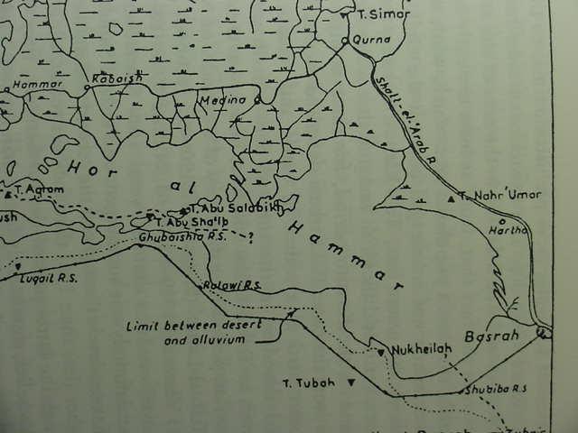
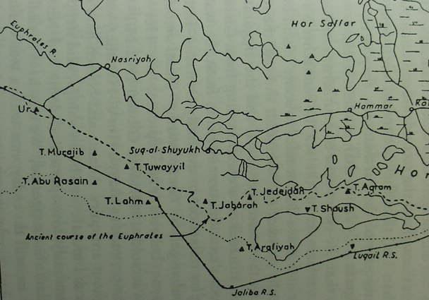
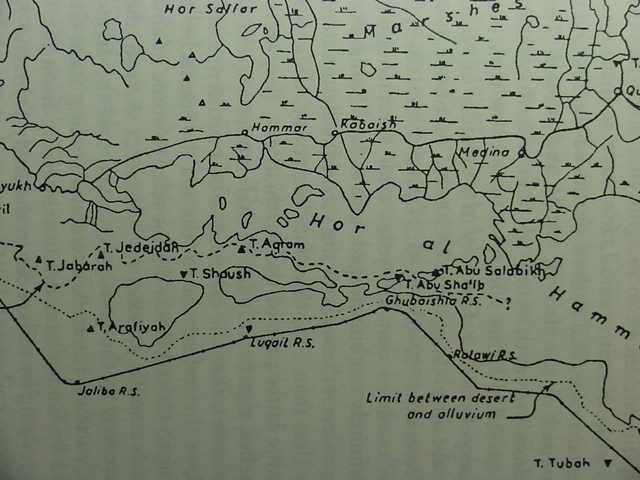
Georges Roux's 1960 map of the Hawr al Hammar Lagoon and area reveals that in antiquity the Euphrates apparently winded its way (the Euphrates being the dotted line extending from Ur to Tell Abu Salabikh) through the marshlands..
Roux discovered along this river a number of ancient settlements dated to the 2d millennium B.C. That is to say Eridu, despite the texts declaring it lay "at the edge of the Sea," was _not_ the easternmost settlement in Lower Mesopotamia!
The marshlands east of Ur and Eridu had the following "pre-Islamic" settlements (Triangles/Pyramids), listed here from West to East of Ur and Eridu (inverted triangles/pyramids are Islamic sites), all of which lay within the "alluvium" boundary caused by the Euphrates' waters, which fed the marshes and the lagoons: (1) Tell Murajib, (2) Tell Abu Rasain, (3) Tell Tuwayyil, (4) Tell Lahm, (5) Tell Jabarah, (6) Tell Jedejdah, (7) Tell Agram, (8) Tell Abu Salabikh, (9) Tell Nahr 'Umar (cf. p. 37, map titled "The Hor-al-Hammar." Figure 1.17. Archaeological sites in the Hor al-Hammar (after Roux 1960: Map 1)." D. T. Potts. Mesopotamian Civilization, The Material Remains. Ithaca, New York. Cornell University Press. 1997. For Roux's commentary accompanying the below map cf. Georges Roux. "Recently discovered ancient sites in the Hammar Lake District (southern Iraq)." Sumer. Vol. 16. 1960. pp. 20-31. Missing from this map is another 2d millennium B.C. site, Tell al Kirbasi between Tells Agram and Abu Salabikh. Please note the four triangles north of the Hor ha Hamar and south of Hor Sallar which are un-named, they apparently mark other 2d millennium B.C. sites?)
Please click here for Dr. Juris Zarins PhD (1992) map of this same area showing similar ancient sites.
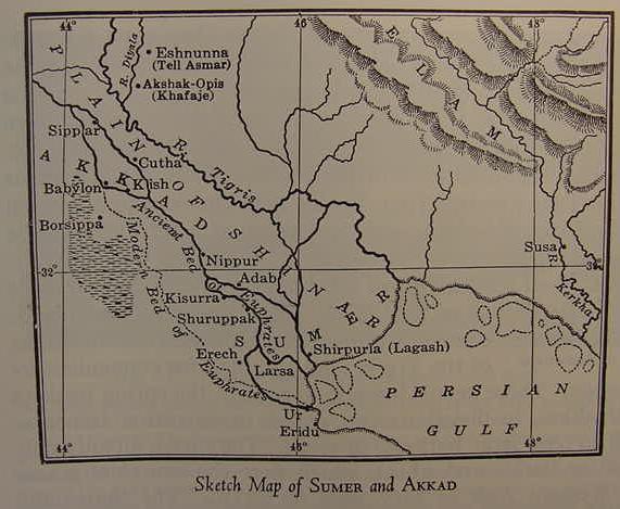
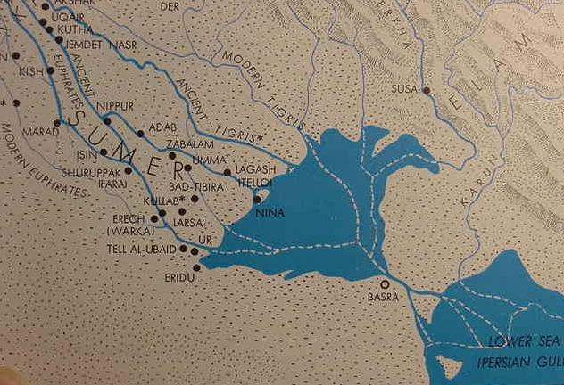
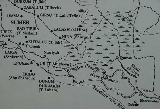
Below, a map showing _incorrectly_ the Persian Gulf (Arabian Gulf) extending to Ur and Eridu, by the way, Eridu on satellite photos is 12 miles SW of Ur, not SE of Ur! (cf. p. 141. James Henry Breasted. Ancient Times, A History of the Early World. Volume I. The Ancient Near East. 1st Edition 1916, 2nd edition. 1967. Boston, Ginn & Company). To this very day, 2008, many are _unaware_ of Roux's 1960 findings and Potts' 1997 note of caution about "the Sea" or Sealand being an area of lagoons, marshes and open areas of land which in antiquity were cultivated in 2d millennium B.C. times. I understand that Dilmun lies in the Sealand. Today the Tigris and Euphrates meet at Qurnah where some Arab traditions fix the location of the Garden of Eden. However, the below map shows the mouths of the Tigris and Euphrates _not_ to be at Qurnah, but at or near Lagash and Ur. The flood-hero variously rendered Ziusudra, Atra-Khasis or Utnapishtim was settled in the land of Dilmun "at the mouth of the rivers," generally understood to be the mouths of the Tigris and Euphrates, but it could just as well be "the mouths of the Euphrates" at Ur and Lagash (Please click here for my article on Dilmun's location).
Heidel on the flood-hero's being settled at the "mouth of the rivers":
"But now Utnapishtim and his wife shall be like unto us gods.
In the distance, at the mouth of the rivers, Utnapishtim
shall dwell!
So they took me and caused me to dwell in the distance, at
the mouth of the rivers."
(p.88. "Tablet XI." Alexander Heidel. The Gilgamesh Epic and the Old Testament Parallels. Chicago & London. The University of Chicago Press. 1946, 1949. Reprint of 1993)
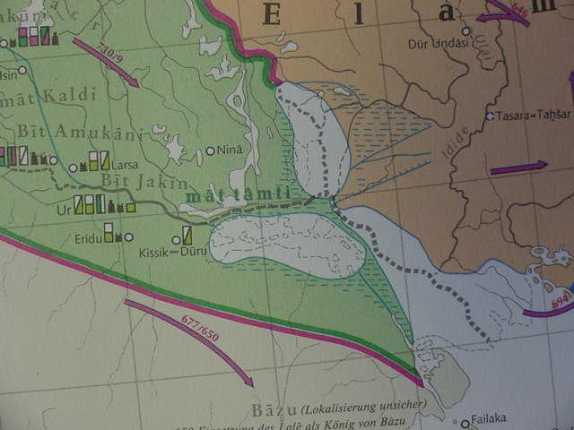
Below, a map showing the Akkadian/Babylonian province called Mat Tamti (mat= land, tamti=sea) or "Sealand" as lying just east of Ur and Eridu in ancient Sumer circa the 8th-6th centuries B.C. and comprising the marshlands which today surround the Hor al-Hammar lagoon. The Cartographers show the Euphrates passing to the north of the Hor al-Hammar lagoon _contra_ Roux's map showing it passed the southside of the lagoon. Today the Euphrates does indeed pass to the north of the Hor al-Hammar lagoon. Perhaps these cartographers were _unaware_ of Roux's research which was published in 1960 and Pott's published in 1997? (cf. map plate: BIV-13."The Neo-Assyrian Empire, 760-612 BC and the Neo-Babylonian Empire, 612-539 B.C." Siegfried Mittmann & Gotz Schmitt, editors. Tubinger Bibelatlas. Tubingen, Deutschland. Deutsche Bibelgesellschaft. 2001).
Professor Albright on the location of Dilmun which he calls the "Babylonian Elysium," being at first in the marshlands east of the mouths of the Tigris and Euphrates rivers (please note Albright is writing this in 1919, just 3 years after Professor Breasted's above map was published in 1916 showing the mouth of the Tigris and Euphrates as entering the Persian Gulf or "Sea" near Lagash and Ur. The Tubinger Bibelatlas reveals this area was called the Sealand or Mat Tamti and Sargon of Akkad boasted of conquering the Sealand and Dilmun):
"According to Babylonian mythology, the flood-hero, Utnapishtim, was given eternal life by the gods after the deluge, and was translated to the pi narati, or "mouth of the rivers"...It is at present quite generally supposed that the pi narati was originally the delta of the Two Rivers, which in early times emptied into the gulf through separate mouths, and that when the Babylonians became better acquainted with the interior of the marshes they removed their Elysium to some distant region toward the setting sun."
(p. 161. W. F. Albright. "The Mouth of the Rivers." pp. 161-195. The American Journal of Semitic Languages and Literatures. Vol. XXXV. No. 4. July. 1919)
Professor Thorkild Jacobsen of Dilmun's setting being the marshes of southern Mesopotamia (Please click here for the full text):
Enki...He brings fresh water underground from the Euphrates at the Sumerian port of Izin and has it fill the large footprints made by the sun god as he steps from Dilmun up into heaven, much as footprints in marshy ground will fill up with water...Dilmun; for the scene of the second story is most naturally seen as the marshes in southern Mesopotamia."
(p. 182. "Enki and Ninsikila/Ninhursaga." Thorkild Jacobsen. The Harps That Once...Sumerian Poetry in Translation. New Haven & London. Yale University Press. 1987. paperback)
Professor Kramer _incorrectly_ thought a great fresh-water lake lay to the east of ancient Sumer (I note this area appears to be the Mat Tamti (cf. the above maps):
"In Sumerian times a large fresh-water lake lay beyond the head of the Persian Gulf."
(For the below map cf. p. 181. Map titled "Sumer and its neighbors." Samuel Noah Kramer. "The Sumerians." pp. 179-190 in C. C. Lamberg-Karlovsky, editor. Hunters, Farmers, and Civilizations: Old World Archaeology. San Francisco. W.H. Freeman and Company. 1979. [This article originally appearing in the Scientific American magazine of October 1957])
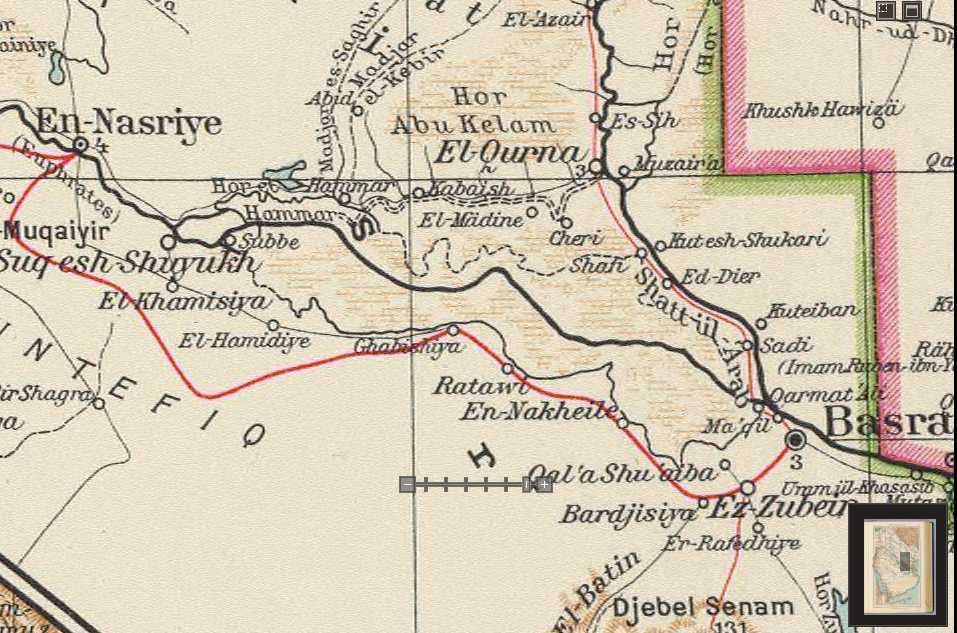
Note: Roux's (1960) map of this region reveals that this area was _not_ a part of the Persian Gulf or a great freshwater-lake, it was apparently a marsh with open areas of land through which flowed the Euphrates in the 2d millennium B.C., several settlements dating to this period being found. As is quite clear from the below map the "mouth of the rivers" (pi narate) where Dilmun was located in ancient texts, was _not_ at Qurna where the white dotted lines converge for the Euphrates and Tigris today, but farther west of Qurna, nearer Ur and Lagash, suggesting Dilmun was _not_ in the Qurnah area as has been argued by Howard-Carter (1980, 1981, 1987)
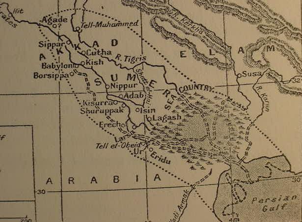
Below, a map of the Sea Land rendered (1928) by Wooley as the "Sea Country" (cf. Illustration No. 2. "Map of Sumer and Akkad." C. Leonard Wooley. The Sumerians. Oxford. The Clarendon Press. 1928, 1930). The dotted line from Agade to the Persian Gulf represents the furthest reach of the Gulf in antiquity as understood _in error_ by some scholars circa 1928. Wooley's map shows the Euphrates divided into two streams near Suk es-Shuyuk, east of Ur, (not on this map), the northern branch headed for Qurnah (not on this map) the southern headed for Basra (not on this map). No doubt these two streams are based on the below 1922 map showing the Euphrates' two branches going to Qurnah and to Basra.
Leick (2001) understands the term "Sealand" is synonymous with the marshes of southern Babylonia:
"Sealand: translation of the Akkadian term for the marshes of southern Babylonia. In the mid second millennium there was a Dynasty of the Sealand mentioned in the King-lists, which profited from the Gulf trade. There was a Second Dynasty of the Sealand in the eleventh century B.C. In the Neo-Babylonian period, it was mainly occupied by Chaldean tribes who fought against the Assyrians, often in alliance with Elamites."
(p. 282. "Sealand." [Glossary]. Gwendolyn Leick. Mesopotamia, The Invention of the City. London. Penguin Books. 2001, 2002)
I note that Roux's above map of the Hor al-Hammar Lagoon and vicinity shows several 2d millennium B.C. tells near a now defunct Euphrates river west and south of the Lagoon. I note also that Leick has observed that a "Dynasty of the Sealand" existed in the same 2d millennium B.C., in texts. Most probably Roux's 2d millennium B.C. sites mark the location of settlements making up the "Sealand Dynasty" of kings. They didn't live in a "sealand," they lived in a "marshland" and Sargon of Agade (Akkad) speaks of conquering the Sealand _and_ Dilmun, which, for me, lies in the midst of the sealand/marshland east of Ur and Eridu.
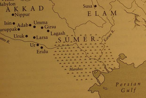
Below, a map showing the Sealand as a land of "Marshes" (cf. pp. x-xi. Map titled "Mesopotamia." Gwendolyn Leick. Mesopotamia, The Invention of the City. London. Penguin Books. 2001, 2002). Satellite photos reveal ERidu lies 12 miles SW of Ur _not_ 12 miles SE of Ur as shown on the below map. Ur lies atop the alluvial plain of the Euphrates while ERidu lies 20 feet below the alluvial plain in a great depression called the Khor el Nejeif, this basin fills up with freshwater during he May floods of the Euphrates to become a great freshawater sea about the sze of the freshwater sea called the Sea of Galilee in Israel.
Below, marshes or swamps are in light brown hatch marks. The Euphrates is shown as a dark line passing through the midst of the marshes from Suq esh Shuyukh to Basra. The Hor el Hammar lake (in light blue) is much smaller in size in 1929 than it is on maps of the 1960s (Iraq. Italian Automobile Touring Atlas. Milan, Italy. 1929). Of interest is that the Euphrates is shown as splitting into two streams at Suq esh Shuyukh: The northern branch heads for Qurnah the southern branch heads for Qarmat Ali near Basra. Maps of the 1960s show that the southern branch has disappeared and been swallowed up by an enlarged Hor al Hammar Lake.
Below, the Hawr al Hammar lake is much greater in size in the 1960s than the above preceding 1922 and 1929 maps. By the 1960s the enlarged Hor al Hammar lake has swallowed up the southern branch of the Euphrates from Suq esh Shuyukh to Basra.
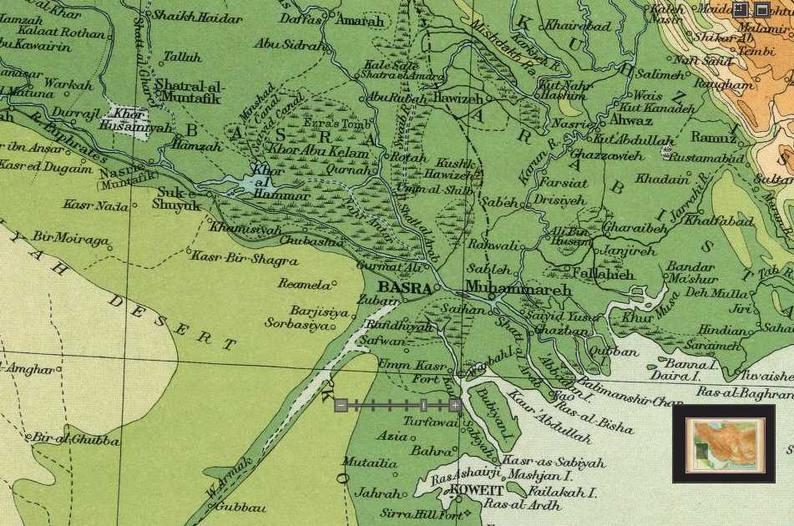
Below, the Euphrates passes through the marshes or swamps as a thin blue line between Suk esh Shuyuk and Basra. The Khor al Hammar lake is much smaller in 1922 on this map than on later maps of the 1960s (Bartholomew. The Times World Atlas. London. 1922). The Euphrates at Suk es-Shuyuk splits into two branches, the northern heading for Qurnah, the southern headed for Qurmat Ali by Basra as in Wooley's (above) 1928 map. Maps of the 1960's reveal that the Hor al Hammar lagoon has engulfed the southern branch to Basra.
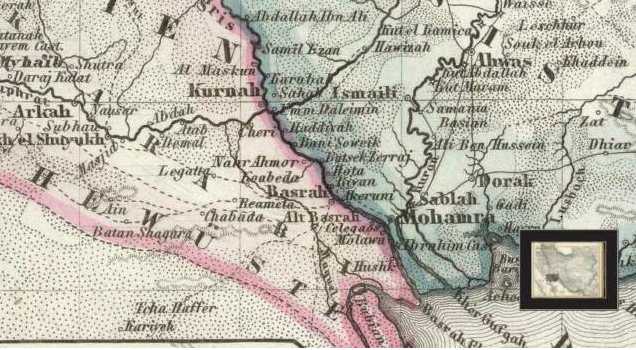
Below, a map of 1860 showing a village called Umm Daleimin east of Kurnah (Qurna). Could this be Dilmun "at the mouth of the rivers"? Daleimin lies to the east of the mouths of the Tigris and Euphrates rivers where they form the Shatt al Arab. Utnapishtim in the Epic of Gilgamesh is placed in Dilmun at the mouth of the rivers to enjoy immortality with the gods.
Below, the same map but in panorama mode. Please click here for the details on Daleimin possibly being Dilmun.