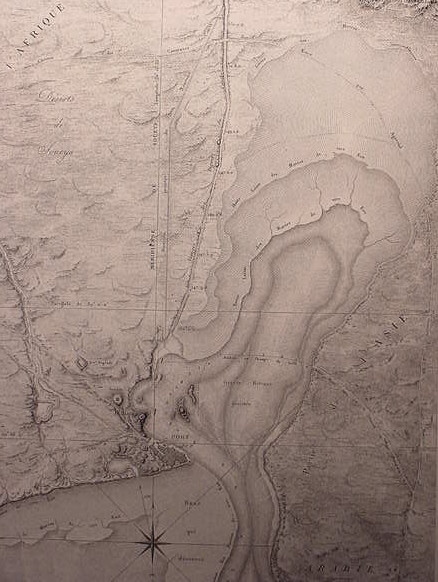
As noted earlier, above, the 4th/5th century AD Christian Pilgrimess Egeria/Etheria stated in her memoirs of her visit to the Sinai and Egypt, that her guides had informed her that Israel crossed the Red Sea near Clysma. This place was a Roman fortress, built earlier by the Emperor Trajan (ca. 98-117 AD), who cleared the Red Sea Canal of sand and utilized it, using the fortress to control entry into the canal. In the 1960's the site was excavated and below it was found an Egyptian Migdol-fortress of Pharaoh Rameses III (ca. 1182-1151 BC). I suspect that "Migdol near Pi-ha-Hiroth" is Ramesses III's fortress. The mouth of the Red Sea Canal is just north of the fortress. Did Ramesses III "clear" the 12th Dynasty canal and build his fortress to control entry into the canal mouth? I understand that Israel waited to cross the Red Sea bewteen Clysma and the mouth of the Red Sea Canal. The route she took might be the route portrayed on the above Napoleonic map (a route from the Nile to the Sinai, starting at the mouth of the canal), which on other 19th century maps is called a Camel ford, utilized apparently at low-tide.
One of the strangest statements made about Israel's crossing of the Red Sea is that a WALL OF WATER surrounded her on either side as she walked on dry land (Ex 14:21-30). And that later, in the morning the "Sea returned to its strength" and inundated the pursuing Egyptian host. I understand that the terminology " the sea returned to its strength in the morning" as suggesting a morning tidal action.
But how does one account for a tidal action creating a "WALL OF WATER" on either side of Israel?
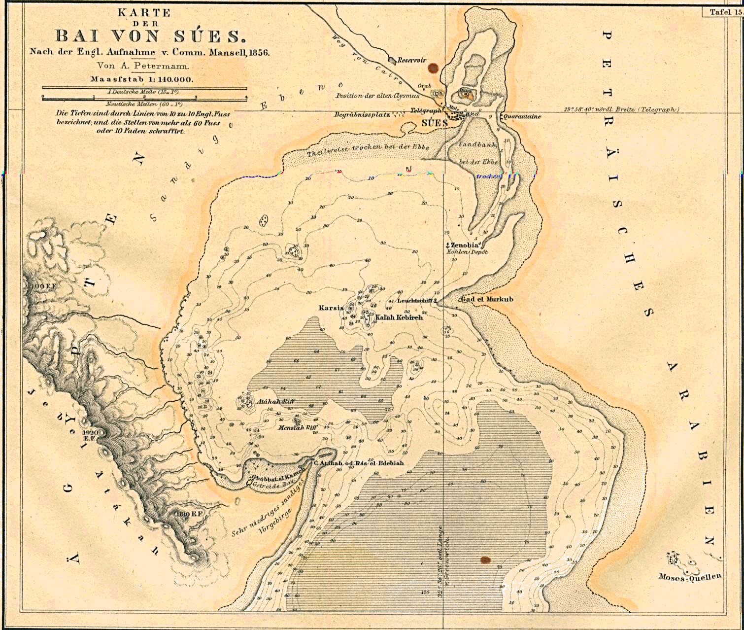
In studying the above maps, I note that at low tide the shallow bay north of the port of Suez and east of Clysma becomes exposed shoals or dry land, with one exception, this dry land is SURROUNDED by a tidal channel fed by the Red Sea. So Israel crossed the Red Sea from between Clysma and the mouth of the Red Sea Canal, following the Camel ford, and was walking on dry land, but the sea channel was completely surrounding Israel like a "wall of water," that is they could see water to the left (north) and water to their right (south) as they headed for the Sinaitic shore. When the 10 foot high tide hit in the morning, the "wall of water," the tidal channel, "disappeared" into the sea again. If I am correct in this proposal for the phenomenon of the "Wall of Water" then the early Christian traditions of the crossing being at or near Clysma are vindicated. Also vindicated is the Bible's description. If I am correct in identifying the Rameside fortress at Clysma as the Migdol mentioned in the biblical account, then we can date the Exodus to no earlier than the days of Ramesses III. This "aligns somewhat" with Liberal scholarship's notion that Israel settling in Canaan is the Iron I period 1200-1100 BC, in Rameside times, with the sudden appearance of over 200+ primitive villages/hamlets of stone in the Hill Country and the destruction of Late Bronze Age Hazor by fire as noted by Joshua and verified by archaeological finds This proposal also validates Professors Kitchen and Hoffmeier's proposals that the Exodus is a Ramesside event (cf. their arguments in their recent books. K.A. Kitchen. 2003.
On the Reliablity of the Old Testament. William B. Eerdmans Publishing Company. Grand Rapids, Michigan; & James K. Hoffmeier. 1996. Israel In Egypt, The Evidence For the Authenticity of the Exodus Tradition. New York. Oxford University Press.)
Of interest here, is that the prophet Nahum speaks of No-Ammon (Thebes) possessing a WALL OF WATER protecting her from her enemies. The term "wall" in Hebrew, xoma, reappears at the Red Sea Crossing incident (my thanks to Peter Kirk of the b-Hebrew discussion list, for this observation on xoma). Thebes lies on the east bank of the Nile. To say the river Nile is also a "sea rampart" for Thebes, may be alluding to the notion that the Nile was also called a Sea in Egyptian, Iuma, a notion preserved to this by the Arabs who speak of the Nile as Bahr Nil, "Sea Nile." The bible also speaks of the Nile as the "Egyptian Sea" whose 7 branches will be smitten by God allowing men to cross its waters on foot (cf. Isaiah 11:15). In antiquity the Nile possessed 7 branches in the Delta area, emptying into the Mediterranean Sea. The Nile flooded the Delta each year creating a great and vast shallow SEA, the villages of the Delta, were built upon elevated landforms scattered about the Delta, when the area flooded, these land forms took on the "appearance of islands" in a vast sea. Today these elevated landforms are still today called called Jezirats or "islands" even though the Aswan Dam prevents the Nile from transforming itself into a vast "Egyptian Sea." Isaiah seems to be making an allusion to Israel's Exodus from Egypt which recalls God's "drying up" a portion of the Red Sea, creating a path for his people. The Red Sea path appears to parallel the highway from Egypt to Assyria. I note that Egypt's Sea (Delta) dried up annually,and the tidal actions at Clysma produced dry land daily. Herodotus noted that some in his day thought the Nile's periodical flooding was bacause it was a part of the mythical Freshwater Ocean (Greek: Okeanos) which surrounded the world (the Jewish historian Flavius Josephus understood the the Gihon was the Nile, and that the four rivers of Eden were part of one great earth-encircling river (the Greek Freshwater River Okeanus?)..
Nahum 3:7-10 RSV
"Wasted is Nineveh; who will
bemoan her?
whence shall I seek comforters for her?
"Are you better than Thebes
that sat by the Nile,
with WATER AROUND HER,
her rampart a SEA
and WATER HER WALL?
Ethiopia was her strength,
Egypt too, and that without limit;
Put and the Libyans were her
helpers."
Yet she was carried away,
she went into captivity..."
Isaiah 11:15 RSV
"And the Lord will utterly destroy the tongue of THE SEA of Egypt;
and will wave his hand over THE RIVER with his scorching wind,
and smite it ito seven channels that men may cross dryshod.
And there will be a highway from Assyria for the remnant which is left
of his people,as there was for Israel when they came up from the land of Egypt."
Professor Humphreys suggests that a phenomenon called "Wind Setdown" cleared the sea of water. He noted this is applicable ONLY to large and deep bodies of Waters, thus he rejects the shallow bodies of water at Lake Timsah and the Bitter lakes, but he suggests the Gulf of Suez would be suitable. He dismisses this notion however, at this gulf, because for it to work a strong breeze must blow "the length" of the Gulf (come from the south) and NOT "across it" from the east as portrayed in the bible (cf. p.248. "Crossing the Red Sea." Colin Humphreys.The Miracles of the Exodus, A Scientist's Discovery of the Extraordinary Natural Causes of the Biblical Stories. 2003. Harper Collins. San Francisco). He argues that the crossing was at the head of the Gulf of Aqaba, where he thinks Wind Setdown could operate, winds blowing the length of the Gulf.
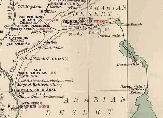
Kraeling mentions a stele erected by Darius I near Tell el Mashkhuta:
"...we know that a canal was constructed by Darius I (521-485 BC), who set up along its course stelas with inscriptions celebrating the event, and recording that it was now possible to sail to Persia by water. One inscribed monument of Darius was even found a half mile from Tell el Mashkhuta at the fresh-water canal."
(p. 102. Emil G. Kraeling. Rand McNally Bible Atlas. Chicago. Rand McNally & Company. 1956, 1962, 1966)
The below map shows the Canal begun by Pharaoh Necho ca. 610 BC and finished by the Persian king Darius I (ca. 521-486 BC). This map shows the location of several stone stelae set up by the Persian king in several languages, Egyptian and Persian, commemorating the completion the canal. The association of Goshen with Saft el Henna, Pithom with Tell el Maskhuteh is after Edouard Naville, a scholar who made these proposals ca. the 1880's after excavations he conducted for the Egypt Exploration Fund at Saft el Henna and Tell el Maskhuteh. He thought the Ramesside statues at Maskhuteh were evidence it was Pithom. Later excavations in the 1980's by Holladay revealed the site has NO Ramesside pottery debris. Today Tell er-Retabeh, west of Maskhuteh (shown below as Tell Rotab) is identified with Pithom because it does have the Rameside pottery debris. Today most scholars associate biblical Succoth with Maskhutah.
Professor Olmstead on the above stela erected by Darius I along his Red Sea Canal (which is estimated to have been 150 feet wide and deep enough for seafaring vessels) :
"Five huge red-granite stelae to commemorate the vast project greeted the eyes of the traveler at intervals along the banks. On one side the twice-repeated Darius holds within an Egyptian cartouche his cuneiform name under the protection of the Ahuramazda symbol. In the three cuneiform languages he declares: "I am a Persian. From Parsa [Persia] I seized Egypt. I commanded this canal to be dug from the river, Nile by name, which flows in Egypt, to the sea which goes from Parsa. Afterward this canal was dug as I commanded, and ships passed from Egypt through this canal to Parsa as was my will. On the reverse is the fuller Egyptian version. Under the Egyptian sun disk, ultimately the original of the Ahuramazda symbol depicted on the front, stand the two Niles in the traditional ritual of 'binding the two lands.' One tells Darius: 'I have given you all the lands, all the Fenku (Phoenicians), all the foreign lands, all the bows'; the other 'I have given you all mankind, all the men, all the peoples of the isles of the seas."
(p. 226. A.T. Olmstead. A History of the Persian Empire Chicago. University of Chicago Press. 1948)
As many are aware a controversy exists on whether the Hebrew Yam Suph means Sea of Reeds or not. The notion that reeds are suggested is drawn from Ex 2:3 -
Exodus 2:3 RSV (Emphasis mine)
"And when she could hide him no longer she took for him a basket made of bulrushes, and daubed it with bitumen and pitch; and she put the child in it and placed it among reeds (SUPH) at the river's brink."
Reeds can grow in freshwater, in Moses' case, the reeds his basket is placed among, line the banks of the freshwater Nile. Ancient traditions, Jewish, Christian and Moslem, understand that Yam Suph is the Gulfs of Suez and Aqaba. The Problem? No reeds have ever been found lining these bodies of water. Now Professor Humpreys did find reeds near the modern Israeli port city of Eilat on the Gulf of Aqaba, but they were not growing "in the sea," rather, they were growing in depressions not too far from the seashore, fed by freshwater runoffs, or seepage and drainage from landforms (cf. p.192 and his photo of the reeds. Colin Humphreys. The Miracles of Exodus, A Scientist's Discovery of the Extraordinary Natural Causes of the Biblical Stories. 2003. Harper Collins. San Francisco)).
Humphreys (emphasis mine) :
"As we have noted earlier, reeds are freshwater plants. Although salt-tolerant reeds and rushes can grow in SLIGHTLY salty lakes, marshes, and ESTUARIES, reeds cannot and do NOT grow in the Red Sea and its two gulfs (Suez and Aqaba) because they are TOO salty. This is true today, and we can reasonably expect it to have been true at the time of Moses because the Red Sea would still have been a saltwater sea." (p. 182. "Where Was the Biblical Red Sea ? Colin Humphreys. The Miracles of Exodus, A Scientist's Discovery of the Extraordinary Natural Causes of the Biblical Stories. 2003. Harper Collins. San Francisco)
Others have noted that in Egypt, reeds can be found not only along the banks of the Nile but at the mouth of the river where it meets the Mediterranean Sea. Here the tidal estuary is a flux or mix of freshwaters and salt waters.
If the Gulf of Suez is Yam Suph as maintained by Jewish and Christian traditions, and if Suph does mean "reeds," how to reconcile the "absence of reeds" in this body of water ?
The answer may lie with the Red Sea Canal, which the Egyptologist, Professor Breasted of the Chicago Oriental Institute (pp. 188, 276. James Henry Breasted. A History of Egypt. N.Y. Scribners Sons. 1912) understood to have been built in the 12th Dynasty by pharaoh Sesostris/Senusret III (ca. 1878-1841 BCE). That is to say, the FRESHWATERS pouring forth from the Nile at Clysma, MIGHT have created an ESTUARY-LIKE ENVIRONMENT in the "shallow bay" adjoining and opposite Clysma (the bay is called Birkhet Kharira on a 1930 map, 1;25,000). If, IF, Ramesses III built his fortress at Clysma to control ships entering the 12th Dynasty Red Sea Canal (having cleared it of sand ?), then, if the Exodus was a Ramesside event, as maintained by some Liberal scholars, the waters in the vicinity of the Clysma Migdol (fortress) and the nearby MOUTH of the Red Sea Canal "may have" possessed Reeds (Suph) in the "ESTUARY-LIKE ENVIRONMENT" of freshwaters of the Nile mingling with the salty waters of the Sea, like what exists at the mouth of the Nile where it meets the Mediterranean Sea ?
The Suez Canal today joins the Mediterranean and Red Seas, connecting Lakes Manzilah, Ballah, Timsah and the two Bitter Lakes. One finds today REEDS GROWING in these lakes. Why? Because freshwaters from the Nile flow into Timsah via Wadi Tumilat, and freshwaters pour into the TIDAL ESTUARY at Lake Manzilah and thence into the Suez Canal.
"The Heroopolitan Gulf [Gulf of Suez] is called by the Arabians Bahr el Kolzum, the "Sea of Destruction"...
(cf.< http://www.godrules.net/library/clarke/clarkeexo10.htm>)
Arabic Kolzum is understood to preserve the Roman "Clysma," a fort being called Clysma near and just north of the port of Suez, erected by the Roman Emperor Trajan to control the Red Sea Canal, which he had "re-opened" and cleared of sand, calling the canal in Latin the "Fossa Triano." The 4th/5th century AD Christian Pilgrimess Egeria/Etheria said her guides told her it was at Clysma that Israel crossed the Red Sea. Clysma is actually from the Greek rather than Latin if I recall rightly. Perhaps Hellenized Jews who were conversant in Greek (to the extent that the translated the Hebrew Bible into Greek as the Septuagint), of Alexandria, Egypt, by the 3rd century BC had come to call the area Clysma in Greek, meaning "destruction" recalling God's "termination" (SUPH, Strong 5486) of Pharaoh, the sea having "consumed" Pharaoh (SUPH, Strong 5487) in the shallow bay opposite the Ramesside Fortress that came to be called Clysma by the Christians?
The Greek root kata' klysm still survives in the English language which preserves many Greek and Latin words : Cataclysm (cata' CLYSM), a violent, usually destructive upheaval.
Professor Batto understands that Suph means "end" so he understands Yam Suph is the "Sea of the End" (that marks the end of the world).
Strong's Exhaustive Concordance for "Red" (5488) as in Red Sea,
renders the following :
5486, cuwph, soof, a primitive root to snatch away, terminate,
consume, have an end, perish.
5487, cuwph (Chaldean), soof, corresponding to 5486, to come to an
end, consume, fufil.
5488, cuwph, soof, probably of Egyptian derivation, a reed, the
papyrus; Red Sea weed.
5489, cuwph, soof, for 5488 by ellipis of 3220, the Reed Sea- Red Sea.
5490, cowph, sofe, from 5486, a termination, conclusion, end, hinder
part.
5491, cowph (Chaldean), sofe, corresponding to 5490, end.
5492, cwphah, soo-faw, from 5486, a hurricane, Red Sea storm,
tempest, whirlwind, Red Sea.
Its just "possible" that Suph could preserve BOTH meanings (if the Red Sea Canal's mouth near Clysma was creating an estuary-like condition of a mix of fresh and salty waters conducive for the growth of reeds) and that a word punning developed, associating cuwph (reed) with cuwph (destruction)? The Hebrews were fond of "word puns," they exist throughout the Bible in Hebrew but are hard to distinguish in English translations.
If Professor Breasted (History of Egypt. 1912. pp.188 & 276) is correct that the Red-Sea canal was created in the 12th Dynasty and used by Hatshepsut to get to Punt by, this means that not only did this canal provide freshwater "in volume" to create a freshwater-saltwater estuary at Clysma-Suez for reeds to grow in, but that EACH of the lakes that the canal passed through, Lake Timsah and two Bitter Lakes ALSO received freshwater allowing reeds (suph) to grow in them as well (cf. Naville's above map showing the Persian Canal's passage through these lakes)! So, from Lake Timsah to Clysma-Suez we would have reeds, the reed seedlings probably being torn loose from the Nile's banks and carried and deposited in these lakes and at Clysma.
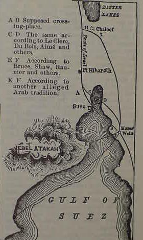
Recently, 21 Jan. 2004, two Soviet scholars (Naum Volzinger, Senior researcher, St. Petersburg Institute of Oceanography and a colleague, Alexei Androsov) have suggested that Israel crossed the Red Sea (Gulf of Suez) via a "reef "located under water and that strong winds from the east exposed dry land for Israel to cross on. "Perhaps" this reef is the one on the "above" 1856 map, it extends from the headland of Ras el Blebish on the west side of the Gulf (east of Jebel Atakah) to the headland of Gad el Murkub on the east side of the Gulf (north of Moses Quellen, "the wells of Moses" modern Ayun Musa). For the details cf. the article titled "2 Mathematicians Dissect a Miracle." St. Petersburg. The Moscow Times.Com <http://www.moscowtimes.ru/stories/2004/1/21/003.html>
"If the wind blew all night at a speed of 30 meters per second, then the reef would be dry...It would take the Jews --there were 600,000 of them-- four hours to cross the seven kilometer reef that runs from one coast to another. Then, in half an hour, the waters would come back."
Conclusions:
The Bible informs us that the reason for Israel's crossing the Red Sea was because she feared to take the "way of the Philistines", a coastal route from Rameses (Qantir) to Canaan, along the south shore the Mediterranean Sea, although the way was near, and it is the "fastest way" to get to Canaan. Many scholars understand that the Philistines are the Pelest mentioned as attempting an invasion of Egypt and Canaan in the days of pharaoh Ramesses III who defeated them and "allowed" them to settle at Gaza, ca.1175 BC. We have at Clysma an Egyptian Migdol (tower-fortress) constructed by Ramesses III, and "cheek-by-jowl" near this fort is the MOUTH of the Red Sea canal, connecting the Gulf of Suez with the Nile. Breasted (1912) suggested that this canal may have been built by the 12th Dynasty pharaoh, Sesostris III (Senusret III, ca. 1878-1841 BC), and that it was in use by Hatshepsut's ships that went to Punt (ca. 1498-1483 BC). Early Christian traditions of the 4th/5th century AD preserved by the Pilgrimess Egeria/Etheria claim the crossing of the Red Sea was near Clysma. I have noted a Camel Ford crossing the bay opposite Clysma BEGINNING AT THE CANAL'S MOUTH (called Birkhet Kharira, which resembles Akkadian Kharru, "canal or channel"). Dry land appears every day at low tide, surrounded by a "wall of water" which is the tidal channel appearing on the above maps. The shallow bay at the time of Israel's crossing could have possessed reeds if the nearby FRESHWATER CANAL opposite the Ramesside fortress was in use and creating an ESTUARY-LIKE ENVIRONMENT similar to the situation where the Nile meets the Mediterranesn Sea.
The convergence of the various elements in the biblical narrative, the mouth of a freshwater canal (Pi-ha-hiroth), creating an "estuary-like environment" permitting reeds (suph) to grow, and a nearby Ramesside migdol-fortress, along with an Exodus from a city called Ramesses (Pi-Ramesses/Qantir), and Philistines/Pelest, appear to be suggesting, for me, an Exodus no earlier than the days of Ramesses III (ca.1182-1151 BC).
16 Jan 2006 Update:
Another "serious problem" in identifying Israel's encampments is that there is _no agreement_ among authorities as to the distance Israel traveled each day between camps.
Professor Hoffmeier noted that several ancient itineraries suggested that caravans consisting of either camels or donkeys could attain a daily rate of 15 to 20 miles, and he suggests that this is Israel's rate of travel in his Exodus campsite proposals. The problem? Other scholars dispute this. They argue that Bedouin nomads who make their living herding goats or sheep usually do not exceed anywhere from 6 to 10 miles a day so as to not exhaust their flocks. They argue that as Israel is portrayed leaving Egypt with flocks of goats and sheep and herds of cattle, it is impossible for her to achieve the daily rate of a camel or donkey caravan. The problem? If Israel's daily rate of travel is determined by her flocks, then she could not have gone more than 6 to 10 miles each day between encampments. This is a "very serious" problem! Why? Because NO PROPOSAL from any authority (biblical scholar) can get Israel from one proposed campsite to another in one day at a rate of 6 to 10 miles a day! As proposed by Hoffmeier, the currently favored campsites are attainable if 15 to 20 miles a day is achieved. To illustrate what I mean: Gebel Musa or Ras Safsafeh near Saint Catherine's monastery is favored by some to be Mount Sinai and either Ain Qadeis or nearby Ain Qudeirat is thought to be Kadesh Barnea in the Negev. We are informed it is 11 days journey by the way to Mount Seir from Mount Horeb (Mt. Sinai) to Kadesh (De 1:2). The actual distance as the crow flies is about 160 miles. This is possible if Israel covers 15 miles a day or 165 miles in 11 days. If her flocks of goats, sheep and herds of cattle allow only 6 to 10 miles a day it is not possible. At 6 miles a day 26 days would be needed. At 10 miles a day 16 days would be needed.
Hoffmeier, refering to Beitzel's investigations:
"This figure precisely lies between the twentyfour and thirty-two kilometers (fifteen and twenty miles) per day that was reckoned based on comparitive travel distances from ancient texts." (p. 144. James K. Hoffmeier. Ancient Israel in Sinai, The Evidence for the Authenticity of the Wilderness Tradition. Oxford & New York. Oxford University Press. 2005. ISBN 0-515546-7)
Beitzel (emphasis mine in capitals):
"Itinerary texts from the Mosaic period stipulate that caravans were able to cover no more than about 20-23 miles per day. With the Exodus, however, the size and the background of the group, when combined with the factors of accompanying women and children and flocks and herds (Ex 12:38; 34:3; cf. 17:2; Nu 20:19), eliminate any possibility...The average daily distance maintained by modern bedouin moving from camp to camp is about _SIX MILES_." (p. 91. Barry J. Beitzel. The Moody Atlas of Bible Lands. Chicago. Moody Press. 1985, 1988. ISBN 0-8024-0438-3)
Bryant G. Wood, a trained archaeologist observes : "A large group of pastoralists moving with their possessions and animals can cover no more than _SIX MILES_ in a day, and usually less (Conder 1883: 79; cf. Beitzel 1985: 91). The limiting factor is the animals. When the Israelites left Egypt, they had "large droves of livestock, both flocks and herds" (Ex 13:38). " http://abr.christiananswers.net/jebel_thoughts.html
Professor Har-El prefers a daily rate of travel for Israel of about 6 miles, based on his once having been a shepherd himself. He is critiquing Shafei's 1946 proposal for the Exodus route from Rameses to Yam Suph (emphasis mine in capitals):
"Shafei's map indicates that the Israelites covered 18 km. on the first day of the journey, 26 km. on the second, and 24 km. on the third. This view is entirely untenable for the following reasons: a) Old people, women and children could hardly progress at such a rate...b) Herds with their young cannot cover such long distances without collapsing on the way (I know this from my own experience as a shepherd); c) Such a large mass of people, weighed down by large quantities of baggage and heavily laden with posessions, could not possibly have made such rapid progress. Conder's observation that the Bedouin who move camp travel at _A MAXIMUM OF SIX MILES A DAY_ also provides support to this point of criticism. His estimate refers to small groups of Bedouin who are properly prepared for their move, in contrast to the large numbers of the Israelites who left Egypt in a hurry, without having made preparations for their journey." (p. 167. Menashe Har-El. " Criticism of Shafei's View." The Sinai Journeys, The Route of the Exodus. San Diego, Calfornia. Ridgefield Publishing Company. 1983. ISBN 0-86628-016-2 [first published in Hebrew 1968, by Am-Oved Publishing Ltd. Tel Aviv])
One individual noted (in an e-mail to me 09 Oct 2005): "Another Archaeologist, Clark Hopkins (of Yale) while directing a dig at Dura-Europas in the Syrian desert, noted that herders were moving 8-10 miles a day in areas where there was not enough pasture to satisfy the small livestock."
All this is to say, that if it is "impossible" for Israel to attain the daily rate of travel of a camel or donkey caravan because of the sheep, goats and cattle accompanying her, then ALL SCHOLARLY PROPOSALS (including my own) ARE DOOMED TO FAILURE, as NONE present an Exodus route based on a daily rate of travel of not more than 6 to 10 miles a day between _all_ the encampments!
Bible scholars such as Burkhardt and Robinson who explored the Sinai's Exodus Route in the 19th century AD did so by camels with Arab guides. These camels' pace was about 2 miles an hour and a day's trek was usually about 10 hours, or roughly 20 miles a day. It is this phenomenon that lies behind their proposals for various sites of the Exodus, assuming a daily rate for Israel of 20 miles. Their proposals based on this phenomenon lie behind the identity of Marah with Ain Hawara, Elim with Wadi Gharandal, Sin with the coastal plain south of Ras Abu Zenimeh, and Gebel Musa being 11 days travel _by camel_ to Ain Qadeis and Ain Qudeirat.
Because of the above "anomalies" I have the following proposals to make:
1) The encampments presented in the Exodus account are perhaps a "late fabrication" of the Iron II period (9th-6th century BC) and are based on a "genuine itinerary" as _achieved by camel or donkey caravans_ which perhaps traversed the southern Sinai from the Negev to Egypt. Their daily rate of travel being 15 to 23 miles a day. I note that archaeolgists found at the Feiran Oasis pottery in the southern Sinai pottery sherds from Iron II Judah of the 9th-8th century BCE. Perhaps a caravan from Judah left these shards enroute to Egypt? If so, then the Exodus route and its encampments may be based on data from such caravans.
2) If 1) is "correct" then it follows that the route of a real Exodus is _not_ recoverable, as sheep, goats and cattle could not achieve the rate of travel of a camel/donkey caravan. Professor Hoffmeier's proposal of sites for the Route of the Exodus is pretty much that of earlier scholars since the 19th century AD explorations by camel of various Bible scholars (Burkhardt, Robinson, etc.). To me it makes sense, a camel caravan's encampments are being preserved in the Exodus account.
3) NO SCHOLARLY PROPOSAL (myself included) for the "Route of the Exodus" -to date- is based upon a _realistic_ travel rate of goats, sheep and cattle of not more than 6 to 10 miles a day for _all_ the encampments.
4) If employing a daily rate of travel for Israel of not more than 6-10 miles a day, the "most likely route" of the Exodus _it appears to me_ would be the Arabic Darb es-Shur, identified by some with the Biblical 'Way to Shur', a track from Beersheba to Muweileh, and Bir el Hasanna, which then crosses the N Sinai terminating at Lake Timsah and the east end of Wadi Tumilat. The problem? Not even this "much shorter route" can be reconciled with the list of encampments from Rameses to Kadesh Barnea, using a daily travel rate of 6 to 10 miles a day. One of the "problems" with this route is that after crossing Yam Suph, Israel wanders 3 days in the wilderness of Shur, then stops at Marah, then Elim, then the shore of Yam Suph AGAIN. If Yam Suph is the region embracing the Ballah Lakes, Lake Timsah, the Bitter Lakes and Gulfs of Suez and Aqaba as proposed by Professor K. A. Kitchen, then where is the SECOND Yam Suph on the Darb es-Shur ?
Please click here (and scroll down to the 15 Jan 2006 update) for Yam Suph's location _if_ Israel's daily rate of travel _was no more than 6 miles a day_ due to flocks of sheep accompanying her as advocated by Conder, Beitzel, Wood and Har-El. Many scholars associate Rameses, where the Exodus began, with Qantir (Pi-Rameses). Day One of the Exodus: Rameses/Qantir to Succoth, 6 miles. Day Two of the Exodus: Succoth to Etham, 6 miles. Day Three of the Exodus: "Turn back" from Etham and encamp before Yam Suph (the Red/Reed Sea). If Israel is "turning back" on herself from Etham to Yam Suph is this sea between 6 to 12 miles from Rameses/Qantir? I have located TWO areas within 12 miles of Qantir which possess bodies of water for Yam Suph. The maps show these bodies of water to be "intermittent lakes", at times dry and other times filled with water. That is to say, ALL the "earlier" scholarly proposals for Yam Suph do not fall within the parameters of between 6 to 12 miles from Rameses/Qantir, such as Lake Bardawil in the northern Sinai, Lake Ballah, Lake Timsah, the Bitter Lakes, the Suez Gulf. The widely held notion that Succoth is a Ramesside Egyptian region called Tjeku in Wadi Tumilat and Etham is near Lake Timsah ALSO FALL OUTSIDE the parameters of sites lying no more than 12 miles from Rameses/Qantir. Of course if Israel "could exceed 6 miles a day" with flocks of sheep and goats and herds of cattle then the parameters can be expanded. To Get to Tjeku/Succoth from Qantir/Rameses in TWO DAYS, the rate of travel would have to be about 20 miles a day. Can sheep, goats and cattle _really_ be driven 20 miles a day? Cattle herds driven to the stockyards of Abilene, Texas covered not more than 10 to 15 miles a day according to sources. If herds of Cattle accompanied the Exodus as suggested by the Bible (Ex 12:38) then this would probably be Israel's daily distance covered as well.