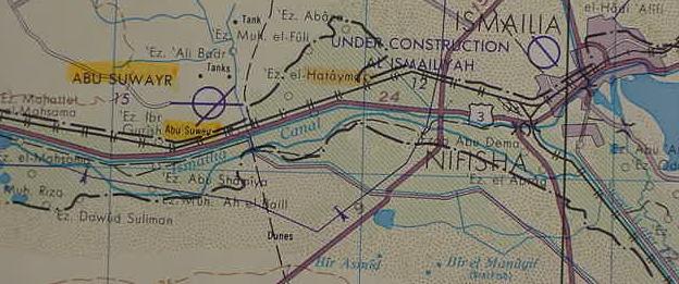
I understand that the wilderness of Shur (Hebrew Shuwr) is named after Abu Suwayr/Suweir in Wadi Tumilat, which lies just east of Tell er Retabeh (not on this map, but west of Suwayr). Etham I understand to be that portion of Wadi Tumilat, which is east of Retabeh. That is to say, Shur and Etham are interchangeable terms for the east end of Wadi Tumilat. Alternately, Etham might be preserved in Lake et-Timsah or at-Timsah meaning "lake of the crocodile" in Arabic.
The wilderness of Shur/Etham Israel marched in for three days I understand to the Isthmus of Suez from Tumilat/Timsah to the Gulf of Suez. The Arabs call the track from the Judaean Negev via Halatza and Muweileh, the Darb esh-Shur, "the way to Shur," which ends at Wadi Tumilat and Ismailia near Lake Timsah. Perhaps Ezbet el Hatayma "the farm of Hatayma," west of Ismailia preserves Etham? The Bible also speaks of the "way to Shur" in the Patriarchal narratives about Abraham and Hagar and Ishmael. If Breasted is correct about a Red Sea canal being built in Dynasty 12 then the freshwaters of Nile could have transported reeds and rushes or swamp grasses to Lake Timsah, the two Bitter lakes and the shallow bay above Clysma/Suez at the head of the Gulf of Suez in antiquity, the freshwaters mixing with salty waters, would create an estuary-like environment for these reeds (biblical suph, Egyptian tsuf). That is to say from Timsah to the Gulf of Suez the area was choked with reeds and swamp marshes because of the freshwater canal (Ismailia, United Arab Republic. 1970. Sheet NH 36-6. Scale: 1:250,000. Washington D.C.). Please click here for an in-depth article on the wilderness of Shur/Etham.
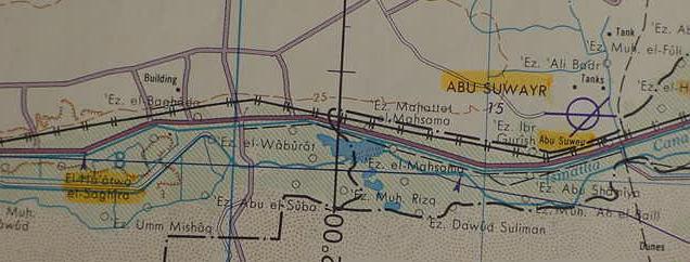
In antiquity a great overflow lake existed in the western half of Wadi Tumilat. On the below map one can trace the escarpment rendered in brown ink where this lake once existed (El Ha`atwa el-Saghira is a site on the northern edge of this defunct lake). I propose that the "birkhet pr-itm" or "pools of Pr-Tum" of Papyrus Anastasi VI (a 13th century B.C. Ramesside document) is this now defunct lake and that "Merneptah's fortress" which guarded its approach is Tell er-Retabeh just east of the lake (Retabeh not shown on this map, but near Ezbet el Waburat on this map). Could Egyptian "itm" usually rendered Atum or Tum, a manifestation of the Sun-god, be the Hebrew Etham? The blue lakes one sees on this map are a more recent phenomenon, to the west of Abu Suwayr. As Israel did NOT have access to "the way of the Philistines" to go to Egypt, they being Israel's mortal enemies in scripture, I am suggesting that in antiquity the freshwaters of the Nile at this overflow lake are the "waters of biblical Shihor" (pronouced in Hebrew as Shee-khore, perhaps preserved in El Ha`atwa el-Saghira, which is highlighted in yellow marker? In Egyptian K and G are interchangeable consonants).
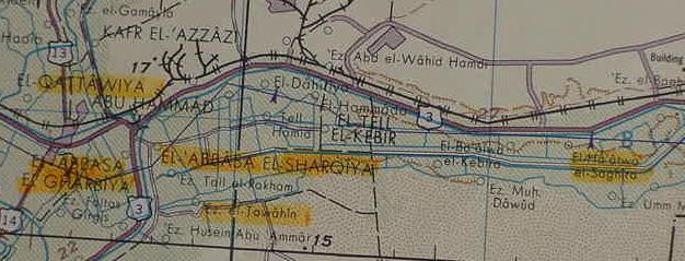
I understand that Rameses is located at Qantir in the Delta. The 4/5th century A.D. Pilgrimess Egeria/Etheria was led to believe by her guides that Rameses and Pithom were in Wadi Tumilat. I suspect that the locations enumerated in the Greek 3rd century B.C. Septuaginta and later the Latin Vulgate Bibles, are in some cases false and misleading. While modern scholarship has identified correctly Heroopolis of the Septuginta and Vulgate traditions with Tell el Maskhutah, as noted by Egeria, I suspect that Pithom has NOT YET BEEN IDENTIFIED. If Ramesses is Qantir in the Delta, Pithom should be in the Delta too, NOT in Wadi Tumilat. As Naville (1885) has noted that Herodotus' Patumos became Roman Thou, I suggest that perhaps Thou is Arabic El Qattiwiya at the west end of Wadi Tumilta in the Delta's edge. Naville (1880's) stated that an alternate ancient Egyptian rendering of Pi-Tum might be Ha-Tum, which the Romans transformed into Thoum and Thou, and he located a Thou at Shugafieh just south of Tell el Kebir, in the west end of Wadi Tumilat Cf. his map for the location. Roman Thou appears to preserved in several yellow-highlighted sites at the west end of Wadi Tumilat, El Qattawiya north of El Abbasa El Gharbiya (Egeria's city of Arabia in Gessen/Goshen?), El Ha`atwa el Saghira on the defunct lake in the wadi, and ezbet el Tawahin just east of El Abassa El Gharbiya at the southside of the entrance into Wadi Tumilat. Perhaps magnometer surveys are needed for this area to "find" Herodtus' Patumos of Arabia (Gharbiya?), just as Qantir is revealing her secrets with magnometers?
I understand that the wilderness of Shur/Etham gets its names from Abu Suwayr and Wadi Tumilat or Lake Timsah, and that this three days in length wilderness is the Isthmus of Suez from Timsah to the head of the Gulf of Suez. After 3 days Israel camps at a place called Marah, rendered by the Greek Septuagint as Merrah. Marah means "bitter" and its waters are bitter. Moses cuts down a palmtree and sweetens the waters. I suspect this site is the two bitter lakes called in Arabic Murrah, preserving the Greek Septuaginta's rendering of the name with two rr's.
We have a "problem" Hebrew mayim is a plural which frequently is used in a singular sense as "water" instead of "waters" (cf. Strong 4325, mayim). Is the proper translation water of Marah (the Septuaginta) or the waters of Marah (Massoretic Text)?
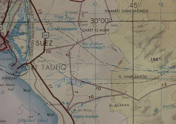
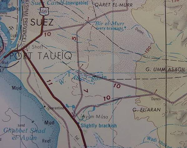
Professor Har-El has (1968) proposed that Marah is Bir el-Murr near a wadi el Murr and a region called Qaret el-Murr on the below map. Bir el Murr is labeled as "very brackish" which would suit the "bitterness" described in the Bible. The problem? Bir el-Murr is a single water source and thus does _not_ seem to fit the biblical notion of the Massoretic Text's "waters." Six miles south of Bir el Murr lies Ayun Musa meaning "the springs of Moses" in Arabic. Two Geologists in 1921 surveyed this site and reported it had 12 springs, 10 were of brackish water and two were of sweet water. I supect that Elim's 12 springs and 70 palmtrees is Ayun Musa. Elim means in Hebrew 'the trees" (the "below maps" are from Suez, United Arab Republic. 1970. Sheet NH 36-10. Scale: 1:250,000. Washington, D.C.) Please click here for an in-depth article on Ayun Musa's 12 springs and palm trees; in 1798 Napoleon noted 15 springs, by 1838 Wellsted noted 20 springs.
Below, a closeup of Bir el Murr, proposed by Professor Har-El to be Marah and Ayun Musa proposed by Har-El to be Elim.Gordon Franz (2001) noted that this site might be Elim because of its 12 springs and Dr. Gregory D. Mumford, a professional Egyptologist also noted that Ayun Musa posseses 12 springs, 10 of which are brackish, two being of drinkable water.
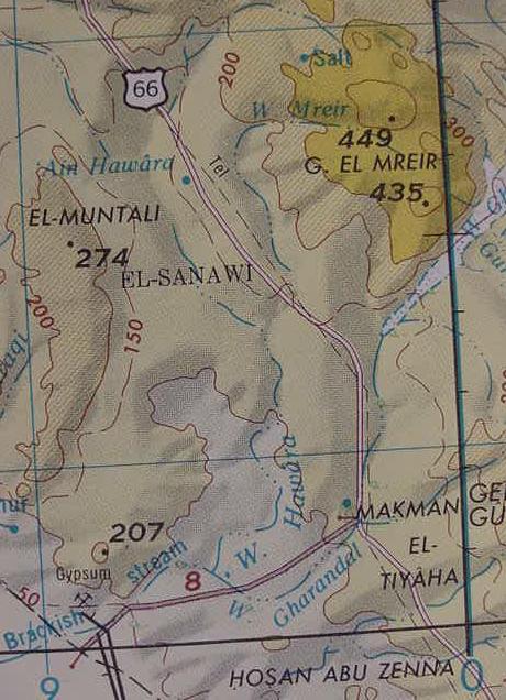
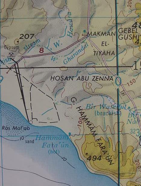
After leaving Elim (Ayun Musa?) Israel next camped by "Yam Suph." I note that south of Ayun Musa the Gulf of Suez is in full panoramic view from the track headed for the southern Sinai. Israel could have camped "anywhere" along this open stretch. Eventually, though, this track passes between mountains which block the view of the sea. I suspect that the high plain called El Sanawi, lying amongst these mountains, to the north of Wadi Gharandel (some scholars identify Wadi Gharandal with Elim), is the "wilderness of Sin." An alternate choice for the wilderness of Sin is another high plain wedged between mountains Hosan Abu Zenna, which is south of Wadi Gharandal and northeast of Gebel Hammum Faraun (the "hotsprings of Pharaoh").
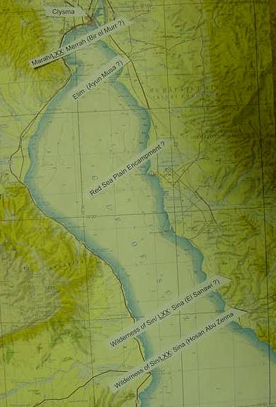
The below Sites are along Yam Suph (Gulf of Suez) which extends from Lake Timsah to the Gulf of Aqaba. The Exodus sites are marked with white tabs from top to bottom : Clysma (Suez), Har-El's Marah LXX: Merrah (Bir el-Murr); Har-El's Elim (Ayun Musa's 12 springs); Red Sea Encampment; Wilderness of Sin (either El Sanawi, north of Wadi Gharandal, or Hosan Abu Zenna, south of Wadi Gharandal). Note: Some scholars associate Elim with Wadi Gharandal, and the wilderness of Sin with the coastal plain of el Merkha, south of Ras Abu Zenimeh not appearing on this map, but 5 miles south of Hosan Abu Zenna. Zenimeh might be the wilderness of Sin? From the wilderness of Sin Israel moved on to