Mount Halak Map (Joshua 11:17; 12:7)
For Christians visiting this website my most important article is: The Reception of God's Holy Spirit: How the Hebrew Prophets _contradict_ Christianity's Teachings. Please click here.
19 November 2004 (Revisions through 24 May 2010)
Cohen identifies Halak with Jebel Halaq in the Negeb:
"A mountain mentioned as the S limit of the conquest of Joshua (Josh. 11:17; 12:7). It is described as being "on the way leading up to Seir" (cf. RSV "that rises toward Seir"), the wooded slopes E of the Arabah. The name and site are preserved in the Jebel Halaq on the NW side of the Wadi Marra, N of 'Abdeh." (p. 512. Vol. 2. S. Cohen. "Halak, Mount." George A. Buttrick. Editor. The Interpreter's Dictionary of the Bible, An Illustrated Encyclopdeia. Nashville. Abingdon Press. 1962)
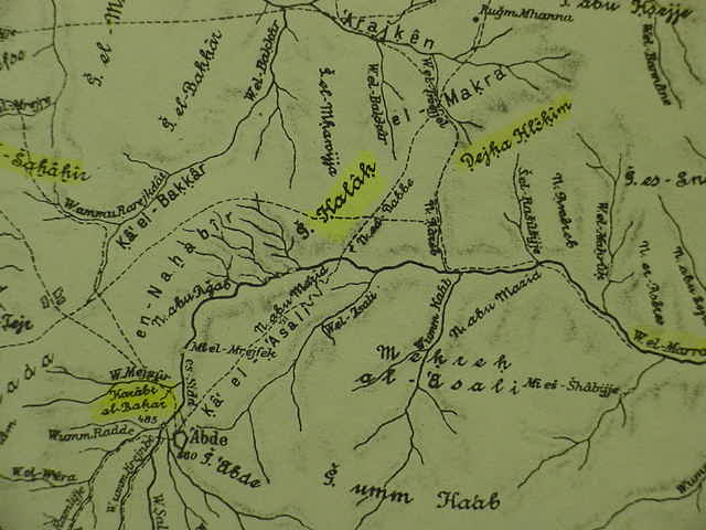
Below, Musil's map showing Jebel Halaq as "G. Halak" just north of 'Abde (Greek: Oboda) which was a Nabatean settlement. Wadi el-Marra drains from the vicinity of 'Abde and Gebel Halak is just N of the wadi. Musil's map also shows an ascent called the "N. Rareb" (Naqb Gareb) following Wadi el Marra, then ascending to the ESE of Gebel Halak and making for Dejka Hlekim and el-Makra (cf. Alois Musil. Karte von Arabia Petraea. Vienna. 1907. 1:300,000 scale)
Most scholars today understand that the "wilderness of Zin" is the drainage basin of Wadi el Marra from the vicinity of 'Abde to the Arabah valley and the Dead Sea.
The problem?
For those scholars understanding that the Exodus occurred ca. 1446 BC citing 1 Kings 6:1, archaeological surveys of this area have documented Stone Age, Middle Bronze I and Iron II sites in the area but no Late Bronze Age (ca. 1560-1200 BC) or Iron I sites (ca. 1220-1000 BC). However, Professor Beno Rothenberg has challenged this notion. He has noted the presence of crude handmade wares from the Negeb called in scholarly parlance "Negebite ware" within the contexts of Ramesside pottery debris at the Egyptian-run mining center in the southern Arabah at the Timna Valley (Har Timna, Arabic: Gebel Mene'iyeh). He has proposed that this Negebite crude handmade pottery has been misdated to the 10th century (Iron II) and that it should be 13th-12th centuries BC.
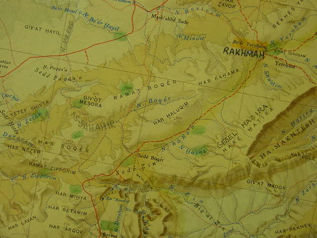
Below, Gebel Halak on a more recent map as "Har Halaqim", har meaning "mountain" in Hebrew. The "wilderness of Zin" appears as Sede Zin and Biq'at Zin along the drainage headwaters of Nahal Zin, formerly Wadi el-Marra on Musil's map. (cf. Survey of Israel. Jerusalem. 1979. South Sheet. 1:250,000 Scale). I have penciled in locations from Musil's map on the below map. His Wadi Mzere is today Israeli Nahal Mesora. Israeli Be'er Yeroham was Arabic Rakhmah. Arabic "Abdeh is now Israeli En Avedat. Musil's N. Rareb" (Naqb Gareb) appears below as Ma'ale Zin, Hebrew for the "ascent of Zin."
I have proposed that the "wilderness of Zin" the Latin Vulgate's Senna, is Khashim Zanna,an elevation S of Tel Masos (Arabic Bir Mashesh) and the Paran is Sahel Fara E of Masos and S of Arad, and that
Kadesh Barnea is Iron IA Tel Masos, the BIGGEST Iron IA site in the Negev (understanding that the sudden appearance of 200+ stone villages in the Hill Country of Judah and Jordan is Israel settling the land under Joshua).
A "problem" with Jebel Halak being Mount Halak is that the proper Hebrew pronunciation is not Halak its Chalaq (Khawlak). One would think that Arabic would preserve the Hebrew pronunciation? The Greek Septuaginta Bible preserves the Hebrew pronunciation:
Halak (Strong numbers):
2510 Chalaq, khaw-lawk', the same as
2509 Chalak, "bare" a mountain of Idumaea from
2505 Chalak, khaw-lak', "to be smooth."
My note: Note the w rendering in pronunciation Khaw-lak, w is sometimes transcribed in Semitic languages as "u" or "o" and Jebel el Qulei'a seems (?) to capture this "w" pronunciation.
(James Strong. Strong's Exhaustive Concordance. "Hebrew & Chaldee Dictionary." Waco, Texas. Word Books. 1977)
Septuaginta (Brenton 1851 translation):
Joshua 11:17
"...from the mountain of Chelcha and that which goes up to Seir..."
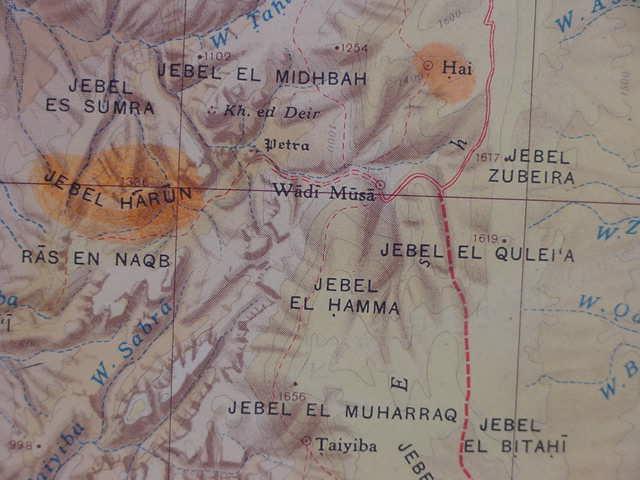
If Edom is E of the Arabah and if its western foothills were Israel's border, could then Mount Hor be Gebel Harun "in Edom's border"? A track ascends E of Harun to Jebel el Qulei'a.
Is Jebel el Quliei'a Mount Halak, Chelcha, Chalaq, Chalak, Khaw-lak'?
The track ascending from Wadi Musa (Wadi of Moses) to Jebel el Qulei'a (elevation of 1619 meters) "might" account for the statement "and that which goes up to Seir" perhaps an allusion to the track ascending the heights of Seir via Jebel el Qulei'a? The Jewish historian Flavius Josephus (1st century AD) places Mount Hor at Petra saying it is called also called Rekem-gaia. Rekem in Aramaic means "holy," perhaps Rekem is an alternate rendering for Hebrew Kadesh meaning "holy"? Gaia might be Hai on the below map N of Jebel el Qulei'a? The Septuaginta preserves Iyim Abarim as Achalgai and Ai which was attacked from Jericho by Joshua as Gai.
In describing Israel's border N to S, Mount Chalaq (Halaq) to Mount Hermon I note Mount Hermon is EAST of the great rift-valley called the Arabah (the Arabah exists between Hermon to the Dead Sea and from the Dead Sea to the Gulf of Aqabah or Red Sea) and that Jebel el Qulei'a is also EAST of the Arabah.
Clearly the Arabah N of the Dead Sea is Israel's but was the Arabah S of the Dead Sea also envisioned as being Israel's?
Joshua claims all the Arabah N of the Dead Sea for Israel:
Joshua 12:1 RSV
"...Israel...took possession...of the Arnon to Mount Hermon, with all the Arabah eastward..."
If Petra is Kadesh-barnea then Israel's statement Kadesh is a city in/near Edom's border then the request to use the King's Highway (denied by Edom) might have been accessed via the ascent to Jebel el Queli'a, that is to say the King's Highway runs N-S across the high tableland of Seir. Some scholars have suggested that this N-S track is the King's Highway.
If Halak is Jebel el Qulei'a then apparently Israel was claiming the Arabah valley south of the Dead Sea all the way to the Red Sea (Gulf of Aqaba) as hers, hence perhaps why God declares Israel's border will be from the Red Sea, the Gulf of Aqaba to the Sea of the Philistines, the Mediterranean Sea (Ex 23:31) and thus Solomon is able to build the seaports of Ezion-Geber and Elath on the Red Sea (1Ki 9:26) by the the land of Edom?
IF, "if" Israel is claiming the Arabah S of the Dead Sea as hers to the lower western slopes of Seir, could the Israelite border description beginning at the Dead Sea 's lower or southern bay (Jos 15:1-4; Nu 34:3-5) be of locations E of the Arabah rather than the more common view the sites are to the W of the Arabah?
In my 30 year plus seach (since 1970) for the Ascent of Akrabbim in Israel's south border I failed to find a toponym in Arabic preserving this site along the western edge of the Arabah.
The current scholarly consensus (with one notable scholarly holdout) is that Naqb el Safa on the west side of the Arabah is the Ascent of Akrabbim and it so appears on modern Israeli maps.
Who's the "holdout"?
The late professor Avi-Yonah stated that Naqb Safa could _not_ be the Ascent of Akrabbim because archaeological surveys on this ascent found no evidence of its being in use in the Iron Age (circa 1220-560 BC). Its archaeological debris was Nabatean of the 4th-1st centuries BC at the earliest.
Another Israeli scholar has proposed that scholars are looking in the wrong place for the Ascent of Akrabbim, he claims it is not on the west side of the Arabah it is on the east side of the the southern bay of the Dead Sea at Umm el Akareb, a track on the SE side of the el Lisan Peninsula, ascending an elevation called Umm el Akareb. Perhaps he is "right"? If he is right then Mount Halak/Chalaq/Khawlak at Jebel el Qulei'a on the East side of the Arabah and Mount Hor at Jebel Harun "line-up like ducks in a shooting gallery." Kadesh-barnea would be Wadi Musa, Josephus' Rekem-gaia. Please click here and scroll down for a map showing Umm el Akareb on the Lisan Peninsula.