Professor Hoffmeier has noted that some early Christian traditions associated Rephidim with the Feiran Oasis on Wadi Feiran but that other more recent scholars have suggested a location called in Arabic Wadi Refayid, within which is an oasis and a mountain by the same name (cf. p. 170. James K. Hoffmeier. Ancient Israel in Sinai, the Evidence for the Authenticity of the Wilderness Tradition. Oxford & New York. Oxford University Press. 2005).
Hoffmeier has suggested the word Rephidim appears to derive from the root rpd, which means help, support, aid, reflecting the divine aid of Yahweh needed to defeat the Amalekites (p. 170. Hoffmeier). Seeley noted that somewhat late Jewish traditions sought to explain the name as dervied from the verb rph meaning to "relax, weaken, dishearten," because there Israel cast off the commandments of the Torah not "to test" or "provoke" God (cf. Jo Ann H. Seely. "Rephidim." Vol. 5. p. 678. David Noel Freedman. Editor. The Anchor Bible Dictionary. New York. Doubleday. 1992)
Despite repeated attempts over the past 10 years I had _no success_ in finding a "Wadi Refayid" on my set of Sinai maps (map scale 1:100,000 made in the 1930's). However, today (10 October 2005) I made a Google Internet search for the "mysterious Wadi Refayid" claimed to possibly be Rephidim by earlier scholars (pre 1980's) and can report "success" at long last! Apparently Wadi Refayid is Wadi Rufayil on my map (Feiran. Sheet 8. Scale: 1:100,000. Survey of Egypt. London. 1937). Is it possible some scholars _in error_ read the last letter L as D?
Here's the "clincher" for Wadi Rufayil being Wadi Refayid:
"Today's first reading (Ex 17:8-13) talks about the power of prayer experienced by the Israelites when they faced enemies on their way to the Promised Land. The tribe of the Amalekites controlled the caravan routes between Arabia and Egypt and hence resented the intrusion of these Hebrews (cf. Dt 25:17-19). They came to fight with the Israelites when they moved from the wilderness of Sin on to Rephidim (today generally located in the Wadi Refayid, 8 miles NW of Jebel Musa). Because of lack of water, people started murmuring (hence the Hebrew term rib, "quarrel" in v.2 prepares us for the later designation of the place as "Meribah"). Here God gave the Israelites water from the rock."
Using the kilometer map scale accompanying my 1:100,000 Sinai map (sheet 8 Feiran for Wadi Rufayil and sheet 9 G. Katherina for Gebel Musa), the distance between Wadi Rufayil and Gebel Musa -as the crow flies- was EXACTLY 13 kilometers ! Using the accompanying map scale it is 11 kilometers (10 kilometers equals 6 miles) from Sheikh Auwad to the foot of Ras Safsafeh and the Plain of er-Raha. Could Reph'idim preserve two nearby sites, Reph' being wadi Rufaiyil and -id being the Early Bronze Age II site of Sheikh Awad?
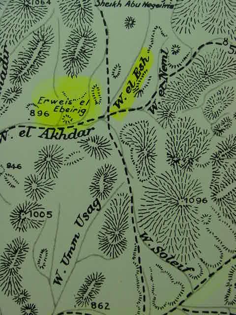
Hoffmeir has suggested that Alush, the camp preceeding Rephidim, might be preserved at a well near
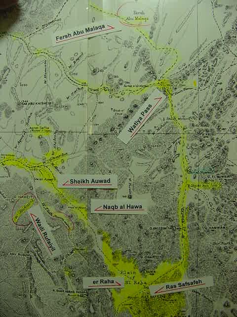
Wadi el-Esh/al-Esh which lies eastnortheast of the Feiran Oasis (p. 169. Hoffmeier). If this identification is plausible, perhaps Rephidim is preserved at Wadi Rufayil near Sheikh Auwad (an Early Bronze Age II encampment), at the northern mouth of a great valley that terminates on the Plain of er-Raha at the foot of Ras Safsafeh, identified by some with Mount Sinai/Horeb.
I note that just north-northeast of Rufaiyil is a Fersh (Plateau) Abu (Father) Malaqa, could this preserve the name Amaleq (the Amalekites) who came and fought with Israel at Rephidim? Some scholars have noted that some Arabic toponyms appear to be preserving Hebrew, Greek and Roman Latin Toponymns of pre-Arabic Conquest times. That is to say the Arabic word while having a different meaning, yet retains the approximate sound or pronounciation. Please click here for my article attempting to identify Amaleq with various similar toponyms preserved in Arabic for the Sinai, Negev and Hill Country of Judah, areas associated with this tribe.
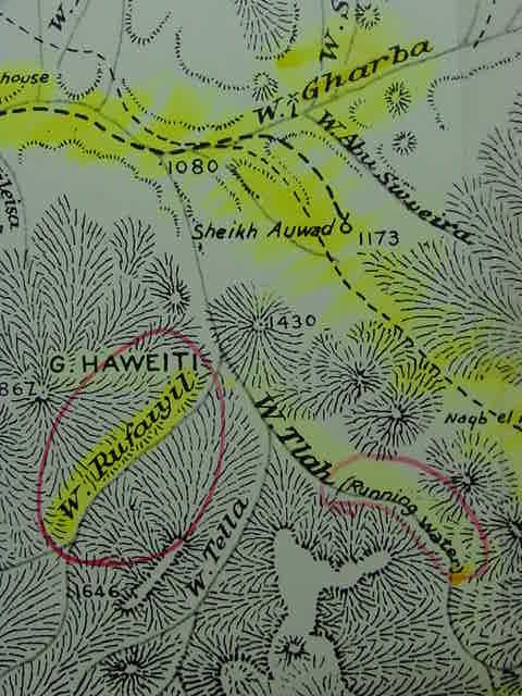
The below map states "Running Water" for Wadi Tlah which intersects with Wadi Rufaiyil on Rufaiyil's east side.. Could this (possibly seasonable ?) "running water" be the river which nourished Israel at Rephidim ? Wadi Rufaiyil lies at the southeast slope of Gebel Haweiti (cf. the below map. Feiran Sheet 8 and G. Katherina. Sheet 9. Map scale: 1:100,000. Survey of Egypt. 1934). Wadi Tlah, if it is a seasonable stream (?) would be near enough to the plain of er-Raha to provide water for Israel.
The Rephidim incident made mention of a rock in Horeb/Choreb that water was obtained from. I note a Wadi Gharba draining from Gebel Banat to the east of Sheikh Auwad meets the stream formed by Wadis Rufaiyil and Tlah. Could Horeb/Choreb be preserved in Gharba? Alternately, perhaps Horeb is Gebel Arribeh east of St. Catherine's monastery? Hoffmeier mentions a stream of water pouring forth from a rock near the monastery:
"The Reverend D. A. Randall, who traveled the Holy Lands in 1862, was likewise impressed with er-Raha plain and Ras Safsafeh...He also noticed that there was a (seasonal) water source located at Gebel Safsafeh, just a ten-minute walk from the monastery, which would have been important to any people staying in the area. He described it in the following manner: "A few rods from us, flowing directly from a crevice in the granite rock of the mountain was a copious stream of pure sweet water. How refreshing, after the stale water we had so long drank!" (p. 145. Hoffmeier)
I note that a modern walking tour map of the area about St. Catherine's monastery shows a spring (number 16 on the map) called "the spring of Symeon" lying to the southwest of the monastery. Could this be Randall's "stream of fresh water" from the mountain ?
It is but a short distance -13 kilometers or 8 miles as the crow flies- from the Rufaiyil area to the Plain of er-Raha where Israel is envisioned by some scholars as camping before the sacred mount beneath the slopes of
Ras Safsafeh (Hoffmeier favors this location for Mt. Sinai, cf. pp. 144-146).
Daily rates of travel for Bedouins vary among scholars, from 6 to 8 to 10, 15 or 20 miles a day with flocks of sheep and goats. Hoffmeier prefers a daily rate of travel for Israel of 15 to 20 miles or 24 to 32 kilometers a day (p. 144. Hoffmeier). Pharaoh Thuthmose marched his army across the N Sinai reaching Gaza to quell rebellion in Canaan in just 11 days, averaging 15 miles a day, but he wasn't burdened down with herds of sheep, goats and cattle as was Israel. If we allow a daily rate of travel of between 6 to 15 miles a day, depending on terrain, water and forage for the livestock, Wadi Rufaiyil (Rephidim?) would be within the parameters of a day's march from Ras Safsafeh and the plain of er-Raha, the distance being roughly 13 kilometers or 8 miles. Wadi el "Esh identified by some with Alush, is approximately 20 kilometers from Wadi Rufaiyil (Rephidim?), or about 12 miles, which would be within the 15 miles a day pace achieved by Thuthmose's troops when they crossed the Sinai.
Hoffmeier:
"This figure precisely lies between the twenty-four and thirty-two kilometers (fifteen and twenty miles) per day that was reckoned based on comparitive travel distances from ancient texts." (p. 144. Hoffmeier)
Bryant G. Wood, a trained archaeologist observes : "A large group of pastoralists moving with their possessions and animals can cover NO MORE THAN SIX MILES IN A DAY, and usually less (Conder 1883: 79; cf. Beitzel 1985: 91). The limiting factor is the animals. When the Israelites left Egypt, they had "large droves of livestock, both flocks and herds" (Ex 13:38). " http://abr.christiananswers.net/jebel_thoughts.html
Professor Har-El prefers a daily rate of travel for Israel of about 6 miles, based on his once having been a shepherd himself (He is critiquing Shafei's 1946 proposal for the Exodus route from Rameses to Yam Suph:
"Shafei's map indicates that the Israelites covered 18 km. on the first day of the journey, 26 km. on the second, and 24 km. on the third. This view is entirely untenable for the following reasons: a) Old people, women and children could hardly progress at such a rate... (b) Herds with their young cannot cover such long distances without collapsing on the way (I know this from my own experience as a shepherd); c) Such a large mass of people, weighed down by large quantities of baggage and heavily laden with posessions, could not possibly have made such rapid progress. Conder's observation that the Bedouin who move camp travel at A MAXIMUM OF SIX MILES A DAY also provides support to this point of criticism. His estimate refers to small groups of Bedouin who are properly prepared for their move, in contrast to the large numbers of the Israelites who left Egypt in a hurry, without having made preparations for their journey."
(p. 167. Menashe Har-El. " Criticism of Shafei's View." The Sinai Journeys, The Route of the Exodus. San Diego, Calfornia. Ridgefield Publishing Company. 1983. ISBN 0-86628-016-2 [first published in Hebrew 1968, by Am-Oved Publishing Ltd. Tel Aviv])
If Professor Harel is correct that herds of sheep and goats cannot be driven more than 6 to 8 miles a day then it is IMPOSSIBLE for Israel to get from Wadi Rufayil (Refayyid) to er Raha via the Watiya Pass and Wadi es Sheikh in one day's time. Palmer, WITH ONLY CAMELS reckoned 6 to 8 hours was needed for this journey, Camels traveling at a rate of 2 miles an hour, suggests a distance of 12 to 16 miles from Refayyid (Rufayil) to er Raha.
We are informed that Israel posssessed ox-carts drawn by two oxen each, and several were dedicated at Mount Sinai to the service of the Tabernacle or tent shrine (cf. Nu 7:3-7). The presence of ox-carts among the Israelites would perhaps then suggest a "maximium" rate of travel of roughly 15 miles a day?
The Exodus narrative also states that when Israel left Egypt she took all her cattle with her, intending to make sacrifices of some of these animals to God (Ex 10:25-26; 10:38). The Exodus account states that a number of bulls and oxen were offered up to God in sacrifices at the dedication of the Tabernacle at Mount Sinai on several successive days (Nu 7:12-88). That cattle can survive in the Sinai is suggested by archaeologists finding the remains of bovines assumed to have been used in sacrifices by the Egyptians at the Hathor shrine at Serabit el Khadim in the 2d millennium BCE, the same era Israel departed Egypt. The Egyptian inscriptions at the shrine also mention bovine sacrifices.
In the American West, which possessed open prairies or grasslands in the 1800's, cattle were generally not driven more than 10 miles a day to prevent weight loss. The more arid lands of the Sinai should be factored in in determing the daily rate of travel for Israel, which would be determined by the cattle accompanying her. Perhaps 10 to 15 miles a day maximum, probably even lower, perhaps 6 to 8 miles a day? The below account of 4 months to travel 1000 miles suggests a daily rate of travel of 8.33 miles:
"In 1867, a cattle trail was established from the Red River in northern Texas, across the Indian Territory, now known as Oklahoma, to Abilene Kansas and the new railroad line to the east. This route became known as the Chisolm Trail. Later, another route from West Texas to Denver Colorado became known as the Goodnight-Loving Trail. This meant that Texas cattle must be driven or walked 1000 miles or more to market. Since cattle can move no more than ten miles per day without losing weight, an average cattle drive from Texas to Abilene, Wichita or Dodge City in Kansas lasted nearly four months." http://www.usatourist.com/english/inside/cowboys2.html
Of interest is that the Exodus narrative suggests that it was the third new moon after she had left Egypt that she came into the wilderness of Sinai (Ex 19:1). She left Egypt the 14th of Abib, the 15th being a new moon; Abib was reckoned as Israel's first month to commemorate her Exodus from Egypt (Ex 13:4). If it took Israel 60 days to travel from Rameses (identified by some with Qantir near Faqus) to get to Mount Sinai (identified by some with Ras Safsafeh by St. Catherine's monastery) the distance is roughly 230 miles as the crow flies, suggesting a daily rate of travel of just under 4 miles per day. That is to say, the cattle and oxen driven in herds, shouldn't have died of exhaustion. The Spring is when the Exodus occurred and this is the rainy season, so perhaps water was available as well as forage? We are not told how many bovines accompanied Israel in the Exodus.
A number of commentators have noted that events at Rephidim appear to be "confused" with events at Mount Sinai, could the nearness of these two sites to each other be the source of the confusion (identifying Rephidim with "the mountain of God")? After Moses' victory over the Amalekites, his father-in-Law Jethro arrives _to the mountain of God_ Hebrew Har El, and blesses Israel's God who has achieved victory over the foe (Ex 18:1,5). The water at Rehidim comes from a rock called Horeb/Choreb (Ex 17:6). I note a wadi Gharba which connects with Wadi Rufaiyil. It flows from a range of mounts on the eastside of the valley that ends at the plain of er-Raha/El-Raha. Egeria stated that upon entering the mouth of a great valley she could see Mount Sinai; this valley is called on modern maps Wadi er-Raha, and it terminates at the plain of er-Raha at the foot of Ras Safsafeh (Note: After clicking on this blue url for the map of Wadi er-Raha you are presented with a reduced map. To enlarge this map to full size for viewing place your browser pointer at the lower left corner of the map and click; a small box will appear with arrows, by repeated clicking on this box the map can be alternately reduced or enlarged. The map was made about 1912) ). From Nagb Hawa, just south of Sheikh Auwad, the peaks are visible which tower over er-Raha. Could wadi Gharba which lies just north of Sheikh Auwad on the below map preserve the stream that issued from the rock of Horeb?
For Christians visiting this website my most important article is: The Reception of God's Holy Spirit: How the Hebrew Prophets _contradict_ Christianity's Teachings. Please click here.
08 October 2005
Revised 28 Dec 2005
Alush
Below, Alush of the Exodus (Nu 33:13-14), which preceeded Rephidim, has been identified by some with Wadi el-Esh/al-Esh, to northeast of the Feiran Oasis. The distance to Wadi Rufaiyil (Rephidim?) is approximately 20 kilometers/12 miles (cf. Map titled Feiran. Sheet 8. Scale: 1:100,000. Survey of Egypt 1934)
Hoffmeier on Alush:
"Burkhardt [1816] reported that he camped at Wadi 'esh, where he found 'a well of sweet water'...Robinson noted that from the juncture of the Wadi 'esh and Akhdar, both Gebel Musa and Serbal were visible...it was later scholars, such as J. Simons and Dewey Beegle, who proposed associating Alush with Wadi 'esh...Some see philological problems with this identification, however, while others prefer to consider Alush as still unidentified."
(p. 169. James K. Hoffmeier. Ancient Israel in Sinai, The Evidence for the Authenticity of the Wilderness Tradition. Oxford & New York. Oxford University Press. 2005. ISBN 0-19-515546-7)
Dophkah
If Alush is preserved in wadi el 'Esh (al-Esh), could Dophkah be preserved at Wadi Foqa which drains west from Gebel Foqa? That is to say [WA]DI preserves Do-, while -phkah is preserved in Foka? This site lies below the et-Tih/El-Tih escarpment forming the eastern perimeter of the great plain opposite Serabit el Khadim called Ramlet Himeiyer (cf. map titled Qal'et El-Nakhl, Egypt. Sheet NH 36-11. 1972. Washington, D.C. Scale: 1:250,000)
Scholars searching for a site appearing north of Jerusalem called Nephtoah have suggested it might be Lifta. If so, then the Hebrew "N" has for some unknown reason been lost and replaced by an "L."
Perhaps a similar thing happened with Dophkah? The "D" disappeared like the "N" of Nephtoah to become Arabic Foqa, the "O" being transposed (ophqa to foqa)?
If Alush is el-Esh, it would make sense that Israel turned inland from the Red Sea coastline just north of Ras Abu Zenimeh and the high plain south of Wady Gharandal called Hosan Abu Zena (the wilderness of Sin?), and entered this great plain (Ramlet Himeiyer), heading south-southeast for al-Esh. Serabit el Khadim's high plateau would lie to her right (west), Wady Foqa to her left (east).
Also favoring this route to Gebel Musa is the ABSENCE of the richest oasis (copious water supply) in the entire southern Sinai, the Feiran Oasis and its date palms. In Late Roman times it was called Pharan, yet there is NO Pharan or Paran listed in Israel's itinerary from Rameses to Mount Sinai. How could such an important oasis and source of year round abundant water go unlisted and unvisited by Israel? Either it had another name in earlier times OR Israel NEVER camped at it, _BYPASSING IT_ via the track east of Serabit el Khadim and west of Wadi/Gebel Foqa to Wadi El Esh and then on to Wadi Rufaiyil (Wadi Refayid?) and Gebel Musa. The ONLY mention of Paran in the Exodus itinerary is AFTER leaving Mount Sinai, it being associated with Kadesh in the Negev.
Rephidim
Palmer (1872) identified Rephidim with the Feiran Oasis on the testimony of a Christian Pilgrim called Antoninus Martyr:
"First, Antoninus Martyr speaks of a small convent or oratory at Feiran, built upon the spot where Moses stood at the battle of Rephidim." (p. 21. E. H. Palmer. The Desert of the Exodus, Journeys On Foot In The Wilderness Of The Forty Years' Wanderings. New York. Harper & Brothers, Publishers. 1872)
However, Palmer did concede that if Gebel Musa was Mount Sinai, it was QUITE IMPOSSIBLE for a huge horde like Israel to get to that location from the Feiran Oasis in one day's time. Palmer had personally explored the two approaches to the plain of er Raha where he believed Israel assembled before Mount Sinai. The nearest approach was via Nagb Hawa "the pass of the wind", the problem was that it was very narrow and not suitable for navigation by a large host of people burdened with ox-drawn wagons, sheep, goats and women, children and elderly. The Nagb Hawa approach was feasible for only a small group traveling lightly. The second approach to er Raha was via the al Watiya pass and the broad plain of Wadi es Sheikh which was AN ADDITIONAL 6 to 8 hours of travel time from the vicinity of the Nagb Hawa pass. Palmer reckoned a day's journey as 8 to 9 hours based on first-hand experience, he traveling with camels to carry his supplies (a camel's rate of travel is 2 miles an hour), and a few Bedouin guides. It would take at least two days for Israel to get to Mount Sinai (Gebel Musa) from the Feiran Oasis if the latter was Rephidim via the Watiya Pass and Wadi es Sheikh.
Palmer:
"The great objection to the identification of Feiran with Rephidim is, that the Bible describes the next stage of the journey of the Israelites thus: 'For they were departed from Rephidim, and were come to the desert of Sinai and pitched in this wilderness. And there Israel camped before the mount' (Exodus 19:2)"
Now, if Jebel Musa be Sinai, it could hardly be reached in a single days' journey by any large host with heavy baggage. From Feiran the road is broad enough and open enough as far as the Nagb Hawa, but the laden camels must make a detour of some six or eight hours by the valley which comes in a little lower down on the left -namely, Wady es Sheik."
(p. 135. E. H. Palmer. The Desert of the Exodus, Journeys On Foot In The Wilderness Of The Forty Years' Wanderings. New York. Harper & Brothers, Publishers. 1872)
Palmer noted that it was approximately 6 to 8 hours from the vicinity of Nagb Hawa to the plain of er Raha via the Watiya Pass and the broad p[lain of Wady es Sheikh, which in turn empties into Wadi ed Deir, and then er Raha. In other words, according to Palmer, it is a day's travel from the vicinity of Nagb Hawa to Gebel Musa. Please note that near Nagb Hawa is Wadi Rufayil which has been proposed by some scholars as being Rephidim (Gebel Haweiti being alternately called Gebel er Refayyid). So, one day's journey from Rufayil/Refayyid brings one to Gebel Musa and the plain of er Raha where Israel is understood to have encamped.
Below a closeup of Wadi Rufaiyil, apparently called "Wadi Refayid" by earlier Bible scholars (pre-1980's) and tentatively identified with Rephidim of the Exodus (cf. John J. Davis. Moses and the Gods of Egypt. Grand Rapids, Michigan. Baker Book House. 1971. pg. 184).
Hoffmeier on Rephidim possibly being being Wadi Refayid, after noting Christian traditions identified the Feiran Oasis with the site:
"The name Rephidim has also been connected by some modern scholars with another valley in the area called Wadi Refayid. Simons agreed with this identification, and pointed out that within the wadi is an oasis and mountain called Refayid. In this case, the Arabic name appears to preserve Rephidim remarkably well. Graham Davies considered the equation between these two names to be a plausible example of the Arabic name preserving an earlier Semitic toponym."
(p. 170. Hoffmeier, citing p. 428. J. Simons. Geographical and Topographical Texts of the Old Testament. Leiden. Brill. 1959)
The below map does not show a Gebel Refayid or oasis.
Note the "running water" of Wadi Tlah that meets Wadi Rufaiyil. Could this be the water that nourished Israel ? Sheikh Auwad has been excavated by Israeli archaeologists and is an Early Bronze Age II encampment (3rd millennium B.C.) with houses built of stone circles. The Christian Pilgrimess (4th century, ca. 383 A.D.?) Aetheria/Egeria's Christian monk guides told her this site was Kibroth Hatta'avah and built by Israel. Egeria's return to Egypt from Gebel Musa involved a 35 Roman mile trip to Pharan, the present Feiran Oasis, where she _again_ stopped at the "Graves of Lust." The Exodus story has Kibroth-hattavah (which means in Hebrew "the graves of Lust"), being encountered enroute to the Wilderness of Paran. Apparently her guides thought Pharan (the Feiran Oasis) was the Paran of the Exodus? (cf. pp. 58-59. George E. Gingras [Translator]. Egeria: Diary of a Pilgrimage. New York & Paramus, New Jersey. Newman Press. 1970)
Below, a closeup of Wadi el 'Esh from the above map (Feiran. Sheet 8. Scale: 1:100,000. Survey of Egypt. 1937)
For another 'contender' for the site of Dophkah please click here for Wadi Dafari and Qattar Dafari ("the well of Dafari") near the coastal plain south of Abu Zenimeh and west of Serabit el Khadim.
Please click here for additional data on the presence of Cattle and Oxen in the Sinai from the findings of archaeology and the testimony of ancient Ramesside Egyptian Annals and European scholars' memoirs as late as 1816 AD.
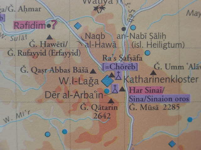
(Update of 28 Dec 2005) Apparently Gebel Haweiti is _also_ known as Gebel Rufayyid or Erfayyidas noted on the below map made for the Deutsche Bibelgesellschaft or "German Bible Society" (cf. map titled "Sinai Archaologie und Geschichte." Siegfried Mittmann & Gotz Schmidtt, editors. Tubinger Bibel Atlas. Stuttgart, Deutschland. Deutsche Bibelgessellschaft. 2001. ISBN 3-438-06022-1)