Various Site Proposals for the location of biblical Mount Sinai or Mount Horeb
Is Jebel Suna on the northside of the plain of er-Rahah
"The Mountian of the Law" in Arabic, Mount Sinai?
03 Sept. 2004
(Revisions through 10 February 2009)
Please click here for Why the Bible cannot be the Word of God
Please click here for my latest map (21 Nov. 2009) showing the site of Israel's "crossing of the Red Sea"
in the Exodus as being at Ras el Ballah (my Baal-zephon)
Numerous identifications exist for the location of Mount Sinai or Mount Horeb. Some of the below proposals are taken from an enumeration of sites by various scholars as noted by Professor Menashe Har-El of Tel Aviv, Israel, who also critiqued the various site proposals (Sinai Journeys, the Route of the Exodus. San Diego, California. Ridgefield Publishing Company. 1983 [First published in Hebrew by Am-Oved Publishing Ltd. Tel-Aviv, Israel. 1968]). Other proposals are what I have "culled" from the Internet using the Internet Search Engine at www.google.com.
No doubt other proposals exist. Articles and books on the subject of the Route of the Exodus and the location of Mount Sinai/Horeb "are legion." This brief article is NOT intended to be an exhaustive and comprehensive listing of "all" the proposals ever made.
There is NO scholarly consensus for the location of Mount Sinai/Horeb.
The problems?
(1) There is no consensus for the date of the Exodus:
One of the "first" problems to be faced is that the Bible exists today in several CONTRADICTING recensions which provide "different dates" for the creation of the world and the Exodus. One often sees the date of 1446 B.C. for the Exodus at many Protestant Evangelical Websites. This date is based on the chronology developed in the 17th century A.D. by Archbishop James Ussher of Ireland which later in the 18th century appears in the margins of numerous King James Version Bibles (the KJV began printing in 1611 A.D.). Ussher calculated Creation at 4004 B.C.
The Catholic Bible is in part a recension of the Septuaginta believed to have been compiled at Alexandria Egypt in Greek for Jews by Jews in the 3rd century B.C. Catholic scholars fix creation at 5199 B.C. instead of 4004 B.C.
Why? Because the Septuagint gives "different ages" for the pre-Flood patriachs which are in CONTRADICTION to ages preserved in the King James Bible.
The data preserved in modern Jewish text the TANAKH also called the Massoretic Text has the Creation calculated at 3740 B.C. by the Rabbinical Seder 'Olam Rabbah according to Professor Steibing but Professor Jack Finegan has the Creation date reckoned at 3761/3760 B.C. (cf. p. 111. Table 54. Jack Finegan. Handbook of Biblical Chronology. Peabody, Massachusetts. Hendrickson Publishers. Revised Edition 1998)
Professor Steibing on three different and _CONTRADICTING_ dates for God's creation of the world found in the book of Genesis as calculated by Jewish, Catholic and Protestant scholars:
"Most scholars agreed that the world was only about six thousand years old, though there was considerable disagreement over the exact date of the creation. Jewish rabbinical calculations from the Hebrew Massoretic Text showed that the world began 3,740 years before the Christian Era. Roman Catholic tradition, based on the Latin Vulgate translation of the Bible, placed the creation in 5199 B.C. And most English-speaking Protestants accepted the seventeenth-century Archbishop James Ussher's calculation of the time of creation, 4004 B.C. Ussher's dates were placed in the margins of early eighteenth-century editions of the King James version of the Bible, making them seem even more authoritive." (p. 32. "The Discovery of Prehistory." William H. Steibing Jr. Uncovering the Past. New York & Oxford. Oxford University Press. 1994 [1993 Prometheus Books])
Thus Protestant Christian Evangelicals set the Exodus at circa 1446 B.C. using Ussher's chronology, the Roman Catholics set the Exodus at circa 1512 B.C. and the Jewish TANAKH's data which appears in the Jewish work called Seder 'Olam Rabbah calculates the Exodus at 1312 B.C. For the 1512 B.C. Exodus date cf. page 190; for 1312 B.C. cf. p. 111 in Jack Finegan. Handbook of Biblical Chronology. Peabody, Massachusetts. Hendrickson Publishers, Inc. 1964, 1998 Revised Edition. ISBN 1-56563-143-9).
The Roman Catholic Exodus date of 1512 B.C. falls in the reign of Pharaoh Tuthmoses II (reigned circa 1518-1504 BC); The Protestant Evangelicals' Exodus date from the King James Version of 1446 B.C. falls in the reign of Pharaoh Amenhotep II (reigned ca. 1453-1419 B.C.); the Jewish Seder 'Olam Rabah's Exodus date of ca. 1312 B.C. falls in the reign of Pharaoh Horemhab (reigned ca. 1321-1293 B.C.), he being succeeded by Ramesses I (reigned ca. 1293-1291 B.C.). Note all Pharaonic reigns are from Peter A. Clayton. Chronicle of the Pharaohs, The Reign-by-reign Record of the Rulers and Dynasties of Ancient Egypt. London. Thames & Hudson. 1994. ISBN 0-500-05074-0)
(2) For some proposals there is an apparent lack of physical evidence for the Exodus:
To date (28 December 2006), no Israelite campsite has been found of the Late Bronze (1560-1200 B.C.) or Iron Age I (1200-1100 B.C.) eras favored by "most" scholars for the Exodus, in any of the locations associated with the event in the Sinai, Negev and Arabah. Thus, "some" scholars have concluded the Exodus did not happen. Others maintain it did and offer an _argument from silence_ in support of their belief. They argue Israel dwelt in tents, used waterskins, and did not use pottery, thus the reason there is no evidence of Israelite encampments. Then another _argument from silence_ is advanced, "the absence of evidence is not proof the event never occurred."
3) Although the biblical text suggests an eleven day journey from Mount Sinai to Kadesh Barnea by the way to Mount Seir (De 1;2), there is no consensus among scholars as to how many miles were covered in a given day by Israel. Some have proposed as liitle as 6 miles to as many as 20 or 30 miles a day. The lower number is generally based on observations of Bedouin movements as they graze their herds or flocks of sheep and goats while the higher number is based on camel and donkey caravans. Some of these scholars noting that Israel left Egypt with just such animals, including bullocks (Nu 7:87-88), all of which were sacrificed at Mount Sinai, have proposed that the distance has to be determined by how hard one can drive herds without exhausting and killing them in a single day, cf. Jacob's comment to Esau (Ge 33: 12-14):
"Then Esau said, "Let us journey on our way, and I will go before you." But Jacob said to him, "My lord knows that the children are frail, and that the herds giving suck are a care to me; and if they are over-driven for one day, all the flocks will die. Let my lord pass on before his servant, and I will lead on slowly, according to the pace of the cattle which are before me and according to the pace of the children, until I come to my lord in Seir."
4) There is no "universal" consensus on the location of Kadesh Barnea. Before 1840 A.D., the site was identified with Petra in ancient Edom, following the identification made by the 1st century A.D. Jewish historian Flavius Josephus. Still later, in the 19th century A.D., it was thought to be somewhere in the Arabah. In 1840 with the discovery of "Ain Gades/Kades" (today's Ain el Qadeis), the site moved to the Negev. Today, nearby Ain el Qudeirat is favored by many.
5) There is no "universal" agreement on the location of Mount Seir. Some understand it lies east of the Arabah valley which extends south of the Dead Sea to the Gulf of Aqaba. Others, that it lies west of the Arabah, in either the Hill Country above Arad or the Negev south of Arad.
6) Some scholars understand that Mount Sinai (Mount Horeb) is a 3 days' journey from Rameses in the land of Goshen in Egypt (cf. Exodus 3:1-2, 12, 18 and 8:27). The problem? Moses is to make sacrifices to God (Ex 3:18) and we learn that these sacrifices consisted of the following animals: bulls (Ex 29:10), rams (Ex 29:19), and lambs (Ex 29:38). While it is possible for a man in good health to walk 20 to 30 miles a day, many scholars understand that herds of cattle, goats and sheep cannot maintain this pace, they will collapse and die of exhaustion. A number of scholars have suggested that 6 miles a day (based on bedouins who herd sheep in the Sinai) is a reasonable pace for shepherds with their flocks. Ergo, if Mount Sinai (Mount Horeb) is a 3 day's journey from Rameses in Goshen and Moses did tell Pharaoh "sacrifices would be made," then this implies that the animals to be sacrificed could make it to the holy mount in 3 days' time (unless Moses was _lying_ to Pharaoh, leading him to falsely believe the animals for sacrifice could get to the holy mount in 3 days' time). Multiplying 3 days times 6 miles a day suggests that Mount Sinai is about 18 miles from Rameses in Goshen. Some individuals have suggested Mount Sinai is 60-90 miles from Egypt's Delta, assuming a man can walk 20-30 miles a day or better, what they have failed to consider is that flocks of animals _cannot_ maintain a man's pace, so Mount Sinai would have to be 18 miles from Rameses where the Exodus began. The texts however reveal that it took Israel longer than 3 days to reach Mount Sinai. According to Exodus 19:1 Israel reached the wilderness of Sinai on the 3rd new moon after they had left Egypt. Quite clearly Mount Sinai was further away from Rameses in the land of Goshen than a 3 day march with animals to be sacrificed, so Moses was apparently _lying_ to Pharaoh in implying to him that the animals to be sacrificed could get to the holy mount in 3 days' time. In the American West cattle were herded from Texas to Kansas at a pace of not more than 10 miles a day, and they had prairie grasslands to forage off of versus the barren Sinai wilderness.
Exodus 3:12, 18; 10:24-26; 12:37-38 RSV
"...when you have brought forth the people out of Egypt, you shall serve God upon this mountain...let us go a three days' journey into the wilderness, that we may sacrifice to the Lord our God...Then Pharaoh called Moses and said, "Go, serve the Lord; your children also may go with you; only let your flocks and your herds remain behind." But Moses said, "You must also let us have sacrifices and burnt offerings, that we may sacrifice to the Lord our God. Our cattle also must go with us; not a hoof shall be left behind, for we must take of them to serve the Lord our God, and we do not know with what we must serve the Lord until we arrive there"...And the people of Israel journeyed from Rameses to Succoth, about six hundred thousand men on foot, besides women and children. A mixed multitude also went up with them, and very many cattle, both flocks and herds."
Northern Sinai Proposals:
Menashe Har-El: Mt. Sinai is Jebel Sinn Bishr
Sinai Journeys, the Route of the Exodus. San Diego, California. Ridgefield Publishing Company. 1983 (First published in Hebrew by Am-Oved Publishing Ltd. Tel-Aviv, Israel. 1968).
For Har-El the Exodus is a 13th century B.C. Ramesside event and the word Sinai is preserved in Gebel "Sinn" [Bishr]. Kadesh is Ain el-Qadeis in the Negev. Har-El suggests the route was north from Wadi Sudr and Jebel Sin Bishr (SE of Ayun Musa), across the Badiet et-Tih "Wilderness of the Wandering," (the Wadi El Arish drainage basin west of Ain el Qadeis). Har-El argues that Paran is described as being near Kadesh hence Paran must lie in the N Sinai, not the S Sinai as argued by Yohanan Aharoni.
Professor Har-El:
"Here are our proofs for identifying this as the mountain of God:
a) The meaning of "suna" in Arabic is tradition or Oral Law among
the Moslems, and that of sanna is made law. The meaning of "bushr"
is to report good news, that of "bushra" is evangelical,
and "bashar" is man. Thus the meaning of Sin Bishr is the reporting
of the Laws, the Laws of man. This name hints at the Giving of the
Law. We should mention that this is the only mountain in the Sinai
peninsula, Midian and Edom where the name Sinai has been preserved
in the form "Sin." (pp. 420-421. Menashe Har-El. The Sinai Journeys,
The Route of the Exodus. Sa Diego, California. Ridgefield Publishing
Company. 1983. ISBN 0-86628-016-2)
I note a mountain peak called Gebel Suna abutting the northern edge of the plain of er Raha (el Raha) where some scholars think Israel encamped before Mount Sinai, which they identify with Ras Sufsafeh which abuts the south edge of er Raha. If Har-El is correct that SUNA means LAW in Arabic, could Suna be the MOUNTAIN OF THE LAW ?
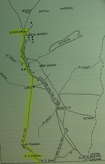
Please click here for a map showing Gebel Suna. That is to say Mount Sinai is possibly on the NORTH side of er Raha plain and NOT the southside?
A glossary accompanying a topographical map on which appears Gebel Sinn Bishr, states that the Arabic word sinn means a "peak" (cf. map titled Suez, United Arab Republic. Sheet NH 36-10. Scale: 1:250,000. Washington DC. 1970).
Hobbs stated that the Bedouin thought that the word Sinai was derived from Arabic sinn meaning a "tooth":
"Bedouins of south Sinai today assert that the name came from the Arabic word for "tooth" (sinn), because the jagged mountains of their homeland resemble canine teeth." (p. 46. Joseph J. Hobbs. Mount Sinai. Austin. University of Texas Press. 1995. ISBN 0-292-73091-8)
According to Professor Hoffmeier (an Egyptologist) Arabic renders
Sinai as "Sena":
"In Arabic, Sinai is written as sena'."
(cf. p. 289. note 93. James K. Hoffmeier. Ancient Israel in Sinai, The Evidence for the Authenticity of the WildernessTradition. Oxford University Press. 2005. ISBN 0-19-515546-7).
A map of the Sinai shows the Sinai peninsula rendered in Arabic as:
"Shibh Jazirat Sina" (cf. p. 127. Britannica Atlas. Chicago. Encyclopedia Britannica, Inc. 1977)
I thus "assume" Hoffmeier's Sena' is the Britannica's Sina ? But what about Har-El claiming Sin/Sinn preserves Suna ("Law") instead of Sina?
Of interest here is a Gebel Sun'a abutting the Plain of er-Raha (el-Raha) in the southern Sinai, north of Ras Safsafeh and Gebel Musa. Could this be "the mountain of the law"? (cf. below for more details)
Critique:
No archaeolgical survey has been done to determine if Jebel Sinn Bishr has Late Bronze Age or Early Iron I debris. Neither Ain el Qadeis (Har-El's Kadesh Barnea) or Ain el Qudeirat (Kadeh-Barnea favored by many scholars) possess Late Bronze (ca.1560-1200 B.C.) or Iron I (ca. 1220-1000 B.C.) debris. In the general area Stone Age, Early Bronze II, Middle Bronze I and Iron II have been attested.
Har-El's (Emeritus Professor of Biblical Geography, Tel-Aviv University, Israel) 1968 proposal that Gebel Sinn Bishr is Mount Sinai, does NOT -strangely- meet "_the very criteria_" by which he "dismisses" other scholar's proposals. He critiques numerous proposals for various Exodus encampments made by other scholars by "over and over again" stressing that Israel could not cover more than 6-8 miles a day. He notes that to correctly site Mount Sinai (Mount Horeb) the biblical statement that it is 11 days from Horeb to Kadesh-barnea by way of Mount Seir (De 1:2) must be factored in. If Har-El is correct about a limit of 6-8 miles a day for Israel, then 11 days equates to a distance of roughly _66 to 88 miles_ BETWEEN Mount Sinai and Kadesh-barnea. He favors Kadesh to be Ain el-Qadeis not Ain el-Qudeirat (cf. p. 335. Har-El). So, Mount Sinai ought to be some 66 to 88 miles west of Ain Qadeis. The problem ? Gebel Sinn Bishr is 200 kilometers or 120 miles west of Ain Qadeis. It is simply _quite impossible_ for Gebel Sinn Bishr to be Mount Sinai using Har-El's criteria! Har-El''s insistence that Israel could travel no more than 6-8 miles a day travel _delivers a fatal blow_ to his proposal that Gebel Sinn Bishr is Mount Sinai (Mount Horeb) because the word Sinn preserves Sinai (cf. p. 421. Har-El) ! Traveling at a rate of 6-8 miles day, it would take Israel 15 (x 8 miles daily) to 20 (x 6 miles daily) days to reach Ain Qadeis from Gebel Sinn Bishr.
Har-El critiques Shafei's proposal on the Exodus encampments being too far apart, favoring Conder's proposal of a 6 mile a day rate of travel:
"Shafei's map indicates that the Israelites covered 18 km. on the first day of the journey, 26 km. on the second, and 24 km. on the third. This view is entirely untenable for the following reasons: (a) Old people, women and children could hardly progress at such a rate...(b) Herds with their young cannot cover such long distances without collapsing on the way (I know this from my own experience as a shepherd); (c) Such a large mass of people, weighed down by large quantities of baggage and heavily laden with possessions, could not possibly have made such rapid progress. Conder's observation that the Bedouin who move camp TRAVEL AT _A MAXIMUM OF 6 MILES A DAY_ PROVIDES SUPPORT TO THIS POINT OF CRITICISM." (p. 167. Menashe Har-El. Sinai Journeys, The Route of the Exodus. San Diego, California. Ridgefield Publishing Company. 1983. ISBN 0-86628-016-2. [first published in Hebrew by "Am-Oved" Publishing Ltd., Tel-Aviv. 1968])
Har-El critques Palmer's proposal that Marah is Ein Hawwarah as unlikely because it exceeds 6-8 miles a day for Israel (emphasis mine):
"After traveling three days in the wilderness of Shur without finding water, the Israelites reached Marah, which in Palmer's opinion is Ein Hawwarah. Considering that the distance between 'Ayun Musa and Ein Hawwarah is 75 km., the question once again is how the Israelites could possibly have covered all this territory in the space of only three days. It must be remembered that with women, old people and children, progress under desert conditions COULD NOT HAVE BEEN MORE THAN 6-8 MILES PER DAY, otherwise both the women, old people and children, as well as the livestock, would have been lost." (p. 195. Har-El)
"The most important fact is that THE DISTANCE BETWEEN Jebel Sinn Bisher and Ein Qudeirat IS 200 KILOMETERS., which may be correlated to the Scriptural text" "Eleven days from Horeb"." (p. 425. Menashe Har-El. Sinai Journeys, The Route of the Exodus. San Diego, California. Ridgefield Publishing Company. 1983. ISBN 0-86628-016-2. [first published in Hebrew by "Am-Oved" Publishing Ltd., Tel-Aviv. 1968])
Jebel 'Araif-e-N'aga, Jebel Yelleg, Jebel Maghara in N Sinai (cf. p.134. Har-El, who does not give the names of the proposers)
Critique:
These sites possess Stone Age and Middle Bronze I sites. But I am unaware of any Late Bronze Age or Iron Age I being found. MB I exists from Qusaima to Bir el Hasana and onwards to just east of the modern Suez Canal near the Mitla Pass on the slopes of Ruweiset el Akheider (cf. pp. 37 & 77. Beno Rothenberg et al. God's Wilderness, Discoveries in Sinai. London. Thames and Hudson. 1961)..
C. S. Jarvis : Mt. Sinai is Jebel Hallal in the N Sinai W of Ain el-Quseima and Ain el-Qadeis (p.239. Har-El). C. S. Jarvis. Yesterday and Today in Sinai. London. W. Blackwood & Sons. 1938.
Critique:
This site possesses Stone Age and Middle Bronze I (cf. p. 37. Beno Rothenberg et al. God's Wilderness, Discoveries in Sinai. London. Thames and Hudson. 1961)..
Professor Emannuel Anati: Mount Sinai is Har Karkom (Arabic: Gebel Ideid) in the southern Negev. Emannuel Anati. Har Karkom, the Mountain of God. New York. Rizzoli Press.1986
Emannuel Anati understands that Har Karkom in the Negev is Mount Sinai despite the fact it does not possess any Late Bronze Age pottery debris but instead Early Bronze Age of the 3rd millennium B.C. He has proposed that scholars "err" in dating the Exodus to the Late Bronze Age (ca. 1560-1200 B.C.), noting that Ai (et-Tell), Jericho, and Arad, mentioned in the Exodus narratives, were not in existence or were unoccupied in the 13th century B.C. (a popular timeframe for the Exodus), yet he understands they were occupied in the 3rd millennium B.C. when Har Karkom was a sacred site. Anati shows a petroglyph found at Har Karkom of the Early Bronze Age which resembles for him the two stone tables given Moses by God. He also notes a general absence of Late Bronze Age campsites in the Sinai, Negev and Arabah for the Exodus and dismisses "arguments from silence" advanced by some scholars, claiming Israel's campsites are not documentable as he has found campsites for the 3rd millennium B.C. and thus they should also exist for later eras like the Late Bronze and Iron Ages. cf. http://www.harkarkom.com/History.php?more=all
Anati:
"It is our opinion that the archaeological evidence at the above mentioned sites [Arad, Jericho, Ai]...seem to indicate that the events and situations...do not date to the 13th century B.C. but rather to the late 3rd millennium B.C." ("Where is Mount Sinai?" http://www.bibleinterp.com/articles/Anati_Mount_Sinai.htm )
Critique:
Despite Anati's pessimissm about any site having encampments of the 13th century B.C., I have noted two locations having just such evidence, Serabit el Khadim in the Southern Sinai and Israeli named Har Timna (Formerly Arabic Gebel Mene'iyeh) in the southern Arabah at the edge of the eastern border of the Sinai in the mountains forming the Sinatic border. While he is correct that Arad, Ai (et Tell) and Jericho existed in the Early Bronze Age, his proposal fails to note that Heshbon and Elealeh (Nu 32:3, 37) in Jordan which were conquered by Joshua, are no earlier than Iron I. Joshua's defeat of a coalition of Canaanite kings at the ascent/descent of Beth Horon has a problem as Beth Horon the Upper and Beth Horon the Lower are no older than the Late Bronze and Iron Age.
Dr. Gerald Aardsma: Mt. Sinai is Har Yeroham (Arabic Gebel Rekhmeh) in the Negev.
Aardsma understands the Exodus to have brought about the collapse of the Egyptian Old Kingdom (Dynasty 6), toward the end of the Early Bronze Age, introducing Early Bronze IV (alternately called Middle Bronze I) to the Negev and Canaan and that Ai (et-Tell), Jericho and Arad mentioned in the Exodus narratives both were destroyed about the same time. He accordingly locates Mt. Sinai in the Negev south of Arad and Beersheba at modern Israeli Har Yeruham or Yeroham (Arabic: Gebel er-Rekhme ) which has Middle Bronze I pottery debris which he regards as physical evidence for the Exodus. He understands that a copiest "in error" recorded 480 years elapsing from the Exodus to Solomon's 4th year (1 Kings 6:1) when it should have read "_1480 years_", locating the event towards the end of the Early Bronze Age.
Critique:
Aardsma's proposal suffers the same problems as Anati's, the absence of Heshbon (Tell Hesban), Elealeh (El-Al), Upper and Lower Beth Horon in the Early Bronze Age.
Central Sinai Proposals:
Randall Styx has proposed two possible sites for Mount Sinai (1) Ras Geneina, (2) Gebel el Dalal, both of which are a part of the western et-Tih escarpment. He suggests that Dophkah is to be associated with the mines of Serabit el Khadim, and Geneina and Dalal lie to the ESE of this area. He thus envisions Israel "ascending" the heights of the et-Tih escarpment.
(cf. pp. 14-15. Randall Styx. The Route of the Exodus, the Location of Mount Sinai and Related Topics. http://www.wls.wels.net/library/Essays/Authors/s/StyxExodus/StyxExodus.pdf )
Southern Sinai Proposals:
Lina Eckenstein (1921) proposed that Mount Sinai was to be associated with Serabit el Khadim. She sought a site that had evidence of an archaeological presence of Semitic peoples affiliated with a "holy" or "sacred" mountainous environment. She noted Semitic inscriptions existed near the Egyptian mines about Serabit el Khadim and an Egyptian built shrine dedicated to two deities Hathor the patron cow-goddess of Egyptian miners and Sopdu (Sopt), an Asiatic warrior-god associated with protecting Egypt's eastern frontier from Asiatic or Semitic incursions. Hathor was envisioned apparently as helping the Egyptians locate copper and turqouise while Sopdu protected them from the Sinai bedouin. Both deities were worshipped and each had their own sacred cave adjacent to each other. (Lina Eckenstein. A History of Sinai. London. Society For Promoting Christian Knowledge. 1921)
Walter Reinhold Warttig Mattfeld y de la Torre:
Rephidim is Serabit el-Khadim, Mount Sinai is Gebal Saniya ESE of Gebal Serabit el Khadim; the rock of Horeb/Choreb is Gebel Gharabi/Ghorabi N of Gebal Saniya. Kadesh is Tel Masos, the earliest and biggest Iron IA site in the Negev.
Note: The general area of Serabit el Khadim has the Late Bronze Age (ca. 1560-1200 B.C.) and Iron I (ca. 1230-1100 B.C.) pottery debris evidence demanded for the correct siting of the Sacred Mount, however, I am not aware of any surveys at the base of Gebel Ghorabi or Gebel Saniya finding such debris. The debris tends to be in area north of these mounts near the Egyptian Hathor shrine. I have identified Moses' shattering of the 10 Commandments on two tables of stone with the shattered tables of stone near the base of mountains bearing Proto-Sinaitic inscriptions left by Asiatic miners at Serabit el Khadim's mines. Also of interest, is that the biblical text suggests that bullocks were sacrified at Mount Sinai by Aaron and Moses. Archaeologists have documented Egyptian inscriptions at Serabit el Khadim mentioning the sacrifice of bullocks to the Egyptian mining goddess Hathor and the partial remains of bullocks have been documented by archaeologists at this site.
Critique:
Where is a "series" of Late Bronze Age/Iron Age I campsites extending from Serabit el-Khadim to Kadesh Barnea and Arad in the Negev? Heshbon (Tell Hesban) did have a few sherds of the Late Bronze Age but no structures. The earliest structures are Iron I and it does not possess walls worthy of its being a capital of Sihon's Amorite kingdom until the 8th-7th century B.C.
Professor Anati, aware that the 13th century B.C. was popular with many scholars for the Exodus, noted that the sacred mount ought to have evidence of 13th century B.C. campsites, but he doubted that _any mount_ in the Sinai could meet this criteria (MY PROPOSAL -the Serabit el-Khadim region- DOES MEET THE CRITERIA) :
Anati:
"Since the Exodus took place in the 13th century B.C., Mt. Sinai should have at its foot remains of 13th century camping sites." Should the date be as certain as some believe, this rule should apply to any candidate for Mt. Sinai, not just to Har karkom. It is probable that not a single mountain in the Sinai peninsula would fit because the 13th centruy B.C. is part of a hiatus in settlement." (Emannuel Anati. Where Is Mount Sinai? http://www.bibleinterp.com/articles/Anati_Mount_Sinai.htm )
I have identified Kadesh Barnea with Tel Halaqim in the Negev. Please click here for the maps.
A few scholars have noted that the Hysksos expulsion of the mid 16th century B.C. might be what the Exodus account is recalling (Cf. Donald B. Redford). Of interest is that Hyksos pottery debris and scarabs have been found at Serabit el Khadim.
The Problem? Where is a series of campsites of the Hyksos era extending from Serabit el Khadim to Kadesh Barnea and Arad in the Negev?
My above proposal that Rephidim is Serabit el Khadim might be "wrong". Rephidim might be preserved in Wadi Rufayil (alternately called Wadi er-Refayid according to some scholars) a headwater of Wadi Feiran. Please click here for a map of Rufayil and its nearby mountain called Gebel Haweiti (Gebel er-Refayid). If Rufayil is Rephidim could Wadi el-Foqa, east of Serabit el Khadim preserve Dophkah? Please click here for a map of Foqa. Alternately could Dophkah be Wadi Dafari to the west of Serabit el Khadim? Please click here for a map of Wadi Dafari. In favor of Dophkah being Wadi Dafari is that E. H. Plamer in 1872 stated that the "best" route for Israel was the seacoast of the Gulf of Suez from Ayun Musa to Wadi Gharandal, to the mouth of Wadi Feiran. Then, follow Wadi Feiran to the Feiran Oasis which he identified with Rephidim, to Nagb Hawa which he thought was the beginning of the wilderness of Sinai, then camping in the plain of er Raha below Ras Sufsafeh near Gebel Musa. He argued that the main body however would have entered the plain via the Watiya Pass past Nabi Saleh to Wadi esh-Sheikh.
Jebel Banat near the Feiran Oasis was suggested by some early Christians (p.373. Har-El)
Critique:
I am unaware of a survey finding Late Bronze or Iron I at this site. Judaean pottery of Iron Age II, the 9th-8th century BCE, however, was found associated with one of the Feiran Oasis tells.
Yohanan Aharoni: Mt. Sinai is alternately called Mt. Paran and Mt. Horeb and is "somewhere" in the southern Sinai, noting that the Fieran Oasis was called Pharan in Greco-Roman times (p. 230. Har-El). Yohanan Aharoni.
The Land of the Bible in Bible Times. Jerusalem. 1962. (written in Hebrew). Aharoni argues that in pre-Moslam times, Christians called Feiran Pharan, and thus the wilderness of Paran is Feiran, and possibly was the name given to the whole of the Sinai peninsula. Har-El rejects this reasoning, understanding Kadesh Barnea is "in" the wilderness of Paran and Zin according to the Bible, suggesting Paran is in the Negev, not the southern Sinai.
Critique:
Early Bronze II and Iron II exists at the Feiran Oasis and vicinity, but no Late Bronze or Iron I.
John Lewis Burckhardt: Mt. Sinai is Jebal Serbal while Mt. Horeb was Gebel Musa or Gebel Catherina near St. Catherine's Monastery (p. 177. Har-El).
In 1816 this Swiss scholar visited the Sinai disguised as a Moslem and suggested that Jebel Serbal was Mount Sinai based on his finding of rock inscriptions there and their absence at Gebal Musa near Saint Catherine's Monastery in his book titled Travels in Syria and the Holy Land. London.1822. Later scholars identified the Jebel Serbal inscriptions as not being Israelite.
Sir William Flinders Petrie: Mt. Sinai is Jebel Serbal (p. 209. Har-El)
Petrie found the plain of er-Raha below Ras Safsafa near St. Catherine's Monastery to be unsuitable for Israel due to a lack of adequate water. He preferred the Feiran Oasis for Israel's encampment due to its water resources, accordingly, nearby Jebel Serbal was Mt. Sinai. He argued the _earliest_ Christian monastery was at Feiran NOT St. Catherine's.
Sir William Flinders Petrie. Researches in Sinai. London. Murray. 1906.
Critique:
I am not aware of an archaeological survey having found any Late Bronze or Iron I in the area. However, Early Bronze II and Iron II, 9th-8th centruy BCE pottery from Judah has been found at the tell which is in the Feiran Oasis which became Byzantine monastery/settlement of Pharan.
S. C. Bartlett : Mt. Sinai is Gebal Musa (p. 197. Har-El).
Kadesh is Ain el Qadeis in the Negev (p. 198. Har-El). S. C. Bartlett. From Egypt to Palestine Through the Wilderness and the South Country. New York. Harper. 1879.
E. Robinson: Mt. Sinai is Gebel Musa.
E. Robinson. Biblical Researches in Palestine and in the Adjacent Regions. 3 vols. London. 1850.
Kenneth A. Kitchen: Mt. Sinai is "probably" Gebel Musa because of its nearby plain below Ras Safsafa. He argues that the Feiran Oasis is too far away (roughly 4 miles) from Jebel Serbal which is too difficult to access if Moses' encampment was in the Oasis (cf. p. 270. Kenneth A. Kitchen. On the Reliability of the Old Testament. Grand Rapids, Michigan. William B. Eerdmans. 2003)
E. H. Palmer: Mt. Sinai is Ras Safsafa near Jebel Musa; Mt. Horeb is Jebel 'Aribeh E of Ras Safsafa (p.187. Har-El) Palmer noted that Gebel Musa was NOT visible from the plain of er-Raha where he thought Israel encamped, only Ras Safsafa was visible, ergo it had to be Mt. Sinai. Kadesh is Ain el Qadeis in the Negev (p. 190. Har-El).
E. H. Palmer. The Desert of the Exodus. New York. Harper & Brothers. 1872.
Professor Hoffmeier in his recently released work (October 2005) seems to favor Ras Safsafa as being Mount Sinai, mainly due to its spacious adjacent plain of er-Raha; his second runner-up for the sacred mount is Gebel Serbal. He notes that neither site has any archaeological evidence of the Late Bronze Age. (cf. pp. 146 & 148. "The Mountain of God." James K. Hoffmeier. Ancient Israel in Sinai, The Evidence for the Authenticity of the Wilderness Tradition. Oxford & New York. The Oxford University Press. 2005. ISBN 0-19-515546-7)
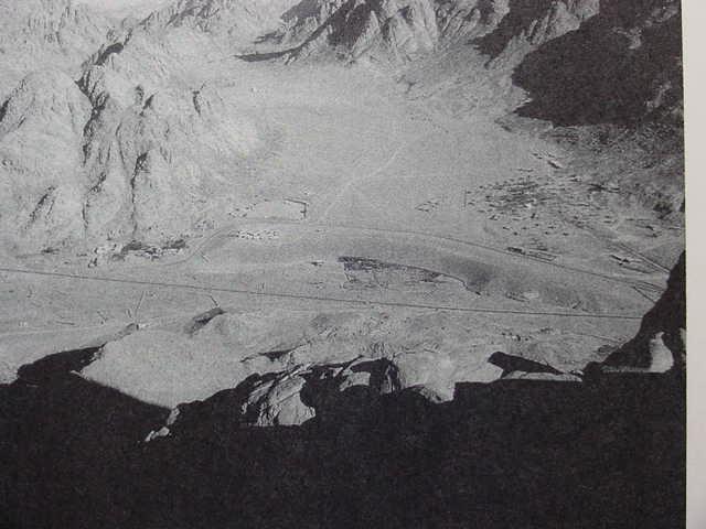
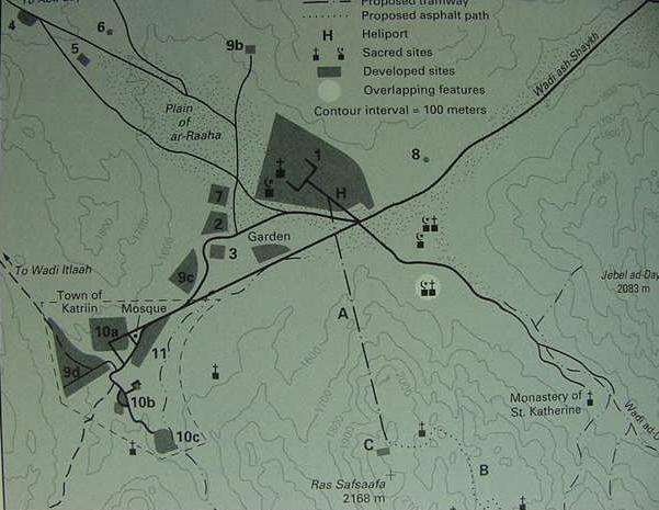
There are other peaks, elevations or mounts near the St. Catherine's Monastery which also vie with each other for the designation "Mount Sinai," such as Ras Safsafa, Gebel Musa (Arabic: "Mount of Moses"), and Gebel Katharina or Catherine (the highest peak in the Sinai, named after the Christian Saint Catherine or Katharina). Scholars favoring Ras Safsafa being Mt. Sinai note that a great plain called er Raha (or el Raha) lies at its northern base, suggesting perhaps Israel assembled on this plain, and that Gebel Musa is NOT visible as Ras Safsafa blocks a view of it from the plain.
I note a Gebel Sun'a with an elevation of 1939 meters lying on the north side of the er Raha plain, opposite the "hill of Harun" and Ras Safsafa which lies on the south side of the plain, whose name "might" preserve Sinai as the 3rd century B.C. Greek Septuaginta version of the Bible preserves the mount's name as Sina (cf. map titled
Gebel Katherina. Sheet 9. Survey of Egypt. 1937. 1:100,000 scale). As noted earlier (above) Har-El argued that Arabic "suna" meant "Law," if he is correct could Gebel Sun'a be the "Mountain of the Law"?
Critique:
I am unaware of an archaeological survey finding ANY KIND OF ARCHAEOLOGICAL DEBRIS in the "immediate vicinity" of Gebels Sun'a, Ras Safsafa, 'Arribeh, Musa and Katherina/Catherina or the nearby plain of er Raha/el Raha which lies at the northern foot of Ras Safsafa with the "exception" of a Neolithic settlement in the plain of el-Raha which was found circa 1994-1995 while building tourist facilities (cf. p. 306. Joseph J. Hobbs. Mount Sinai. Austin, Texas. University of Texas Press. 1995. ISBN 0-292-73091-8). The ONLY DEBRIS in the immediate area is Late Roman and Byzantine of the 4th through 9th centuries A.D. The "nearest" location possessing ANY KIND of earlier archaeological debris is at Sheikh Nabi Saleh in Wadi esh Sheikh some four miles ENE of Saint Catherine's Monastery. At this location exists huts, corrals for sheep and goats and burial tumuli of copper miners from Arad and the Negev who worked the copper mines of Wadi Riqeita, some 8 miles ENE of St. Catherine's Monastery in the Early Bronze II period. The nearest archaeological site to the WNW of St. Catherine's Monastery and Gebels Ras Safsafa, Musa, Katherina and Arribeh, is at Sheikh Awad, another Early Bronze II site with remains of huts, corrals and burial tumuli, just north of Naqb Hawah, some 8 miles WNW of Ras Safsafa. According to the 4th/5th century A.D.(?) Christian Pilgrimess Egeria (variousy called Etheria or Silvia), the holymen who served as her guides pointed out various stone circles in the valley approaching Mount Sinai (Gebel Musa?) that were huts built by the Israelites during "the year" that they dwelt at Mount Sinai. From Egypt there are only two valleys to approach Gebel Musa from; one is via Sheikh Awad and Naqb Hawah, the other is via the Watia pass and Sheikh Nabi Saleh; in either case BOTH valleys or wadies have these stone circles which have been archaeologically excavated and dated to the Early Bronze II (ca. 3000-2700 B.C.), NOT Late Bronze Age (ca. 1560-1200 B.C.) or Early Iron I (ca. 1220-1000 B.C.).
One must remember that until Sir Flinders Petrie and his successors developed pottery chrononologies associated with Egyptian pharaonic cartouches NO ONE had any idea as to how old ANY site was in the Sinai, Negev or Arabah. If the Judaeans who left their Iron II 9th-8th century B.C. pottery at the Feiran Oasis identified Mount Sinai with Ras Safsafa or Gebel Musa, then they probably did so on the basis of the Early Bronze II encampments that they found throughout the southern Sinai, in error thinking they were Israel's (just as the Christian guides were misinformed in Egeria's day).
The Arabah :
Walter Reinhold Warttig Mattfeld y de la Torre: Mt. Horeb is Gebel Mene'iyeh (Israeli: Har Timna) in the southern Arabah, N of of the modern port of Eilat. Note: This site has Late Bronze Age (ca. 1560-1200 B.C.) and Iron Age I (ca. 1200-1100 B.C.) pottery debris demanded by scholars for "correctly" siting the Sacred Mount. I understand events at Gebel/Jebel Mene'iyeh are fused with events at Serabit el Khadim in the S Sinai which also has the same pottery debris. Mene'iyeh has 13th century B.C. Ramesside pottery debris (Ramesses II - Ramesses V, ca. 1279-1141 B.C.), as well as debris identified by its excavator, Professor Beno Rothenberg, as being Iron I Amalekite (Negev wares) and Midianite (al-Qurayya Wares). Rothenberg has documented some campsites between the Negev and Har Timna suggesting a route used by the miners via a track passing Makhtesh Ramon.
Edomite Proposals:
Charles H. Beke: Mt. Sinai is Jebel Baggir, and nearby Ertowa is Horeb, both are NE of the port of Aqaba, near Wady Yutm (p. 252. Har-El). Etham is Wadi Yutm NE of the port of Aqaba (p. 251. Har-El).
Charles H. Beke. Sinai in Arabia and of Midian. London. Trubner & Co. 1878.
A. Lucas: Mt. Sinai is Jebel Baggir near Wadi Yutm NE of the port of Aqaba (p. 275. Har-El)
Kadesh is area of Ain el Qadeis, Ain el Qudeirat and Ain el Quseima (p. 273. Har-El)
A. Lucas. The Route of the Exodus of the Israelites from Egypt. Edward Arnold & Co. 1938.
Critique:
I am unaware of a survey of the area esablishing what period, if any, is attested.
Ditlef Nielsen (a Danish Scholar): Mt. Sinai is Zibb'atuf just to the S of Petra in ancient Edom (cf. p. 281. Har-El) Kadesh is Ain el Qadeis in the Negev (p. 283. Har-El). However, according Andrew Collins, Ditlef Nielsen identified Mount Sinai with the rockhewn highplace and its steps atop Gebel al-Madhbah, west of Petra's rockhewn necropolis. Andrew Collins and Graham Phillips both agree with Nielsen's proposal.
Ditlef Nielsen. The Site of the Biblical Mount Sinai: A Claim for Petra. Copenhagen. 1928.
Critique:
Gebel al Madhbah's rockhewn highplace is Nabatean, no earlier than the 4th century B.C. There is no Late Bronze Age or Iron I at or near the mount.
Arabia Proposals (Midian, Saudi Arabia and Yemen):
Ron Wyatt, Robert Cornuke, David Halbrook, David Fasold, Larry Williams, Howard Blum and Lennart Moller all argue that Mount Sinai is Jebel al-Lawz in NW Saudi Arabia, ESE of the port of Aqaba (Apparently Wyatt in 1984 was the "first" to make this identification).
Critique:
The archaeological debris identified by these scholars with Israel near Jebel el-Lawz, is, according to professional archaeologists, no earlier than the Nabatean period, the 2d century B.C. through 2d century A.D.
Robert Cornuke and David Halbrook. In Search of The Mountain of God: the Discovery of the Real Mount Sinai. Broadman and Holman. 2000.
Howard Blum. The Gold of Exodus, the Discovery of the True Mount Sinai. Simon & Schuster. 1998.
Larry R. Williams. The Mountain of Moses: the Discovery of Mount Sinai. Wynwood Pr. 1990.
Lennart Moller. The Exodus Case: New Discoveries Confirm the Historical Exodus. Scandinavia Publishing House. 2000.
Colin J. Humphreys: Mount Sinai is a Volcanic Jebel Bedr north of Al-Ula and Medina in Saudi Arabia.
He understands that the Exodus was a Ramesside 13th century B.C. event and that Mount Sinai is a volcano and volcanic fields exist in this area called Harrat in Arabic. Kadesh is Ain el Qudeirat or Ain el Qadeis in the Negev. Etham is Wadi Yutm NE of the port of Aqaba.
Colin J. Humphreys. The Miracles of Exodus, A Scientist's Discovery of the Extraordinary Natural Causes of the Biblical Stories. HarperSan Francisco. [Harper Collins Publishers]. 2003.
Critique:
I am unaware of an archaeological survey for Gebel Bedr. Neither Ain el Qadeis or Ain el Qudeirat have any Late Bronze Age or Iron I pottery debris in their general area, only Stone Age, Early Bronze II, Middle Bronze I and Iron II.
Alois Musil : Mt. Sinai is Se'ibal-harob 30 km. south of al-Badia in Midian (cf. pp. 252, 253. Har-El) Kadesh being Petra.
Alois Musil. The Northern Hegaz. New York. American Geographical Society. 1926.
Critique:
I am unaware of an archaeological survey for Gebel Bedr.
Kamal Salibi: Mount Sinai is Jabal Hadi in SW Arabian peninsula.
(The above is noted in a review of Salibi's arguments by E. J. de Meester at http://home-3.tiscali.nl/~meester7/engarabia.html cf. Kamal Salibi. Did the Bible Come From Arabia? 1984).
Critique:
I am unaware of an archaeological survey for Gebel Bedr.
Michael S. Sanders: Mount Sinai is a volcano in a Harrat site in the Yemen called Arhab;
Kadesh is Mecca in Saudi Arabia (following Imannuel Velikovsky's earlier identification).
Critique:
I am unaware of an archaeological survey for Gebel Bedr. He also argues that Mecca is Kadesh Barnea.
Conclusions :
Although there is no "universal" consensus for the date of the Exodus, many Liberal scholars favor a 13th century B.C. date for the event as was noted above by Professor Emannuel Anati. Despite Anati's skepticism that _any_ mountain in the Sinai possesses the neccessary 13th century B.C. pottery debris at its foot indicative of an Asiatic peoples from Egypt, I have noted that just such a location exists in two places; both are Egyptian mining camps serviced by shrines to the mining goddess Hathor. 13th century B.C. Ramesside inscriptions exist at both Serabit el Khadim and vicinity as well as Har Timna and vicinity on the very edge of the Sinai Peninsula where the western border of the southern Arabah rift valley meets the mountains forming the Sinai's eastern perimeter. I have argued elsewhere that events occurring at both sites have been fused together and lie behind the Exodus motifs associated with Mount Sinai (Mount Horeb).
Despite numerous locations proposed for Mount Sinai or Horeb, no scholarly consensus has been reached because archaeologists DEMAND archaeological proof of encampments in the form of pottery debris from either the Late Bronze Age, for those arguing the Exodus was ca. 1446 B.C. as suggested by 1 Kings 6:1 (some Protestants), or the Early Iron I Ramesside era (some Liberals) as Israel is said to have begun its Exodus from a place called Rameses and the sudden appearance of 200+ villages of stone in Iron I in the Hill Country of Canaan is for these scholars the settlement of Israel in Canaan under Joshua.
Dr. Pinch has suggested that the Timna copper mines MAY have been worked as early as Pharaoh Amenhotep III (ca. 1386-1349 B.C.) of the 18th Dynasty, if her proposal is correct, then we have evidence for TWO sites possessing "the required" Late Bronze Age (ca. 1560-1200 B.C.) and Early Iron IA (ca. 1220-1100 B.C.) pottery debris to correctly site Mount Sinai or Mount Horeb, the Egyptian-run mining camps of Serabit el Khadim in the southern Sinai and Har Timna in the mountains forming the eastern border of the Sinai:
"On the basis of the inscribed faience, Rothenberg (1972.132, 171) and Schulman (1976.117, 126) date all the Egyptian faience from Timna to the Ramesside period. Only 25 pieces of votive faience inscribed with royal names were recovered from the temple, compared with nearly 500 from Serabit el-Khadim. The royal names mentioned are Seti I, Ramesses II, Merenptah, Seti II, Tawosret and Ramesses III, IV, and V (Schulman in Rothenberg 1988.145). At Serabit el-Khadim the date range of the 'royal name' faience is from Amonhotpe I to Ramesses VI, but the Ramesside rulers seem to have dedicated a much greater quantity and wider variety of inscribed faience than the 18th dynasty rulers did (1.4.3). Given this, and the troubled history of the Timna temple, if offerings were made there during the 18th dynasty, one would expect only a small proportion of the surviving faience to be of that date.
Most of the non 'royal name' Timna faience can be dated to the Ramesside period by style, technique and material, but some categories provide exceptions. The evidence of the comparitive material from Deir el-Bahri and Serabit el-Khadim suggests that some of the cat figurines found at Timna are 18th dynasty...One of the Timna Hathor masks (1988 fig. 30.1) is similar to the 18th dynasty pieces from Deir el-Bahri (e.g. Pl.30). The fish and flower decoration on some of the faience bowls is of a type usually dated to the 18th dynasty...The use of spiral decoration around the rim of bowls decorated with fish and flowers is charcteristic only of the 18th dynasty (2.11.3.1). Some of the beads common at Timna, such as the corrugated sheroids and gadrooned discs, are usually dated to the 18th dynasty...Much of the glass and some of the pottery could date to the late 18th dynasty (1.5.2). On the basis of the objects themselves, I would suggest that offerings were being made at Timna as early as the reign of Amonhotpe III." (pp. 66-67. "Timna." Geraldine Pinch. Votive Offerings to Hathor. Oxford. Griffith Institute, Ashmolean Museum. 1993. ISBN 0-900416-55-6 pbk)
"The Timna temple was an Egyptian foundation dedicated to Hathor, Lady of Mefkat [Turquoise]. It was used by copper mining expeditions. A shrine may have existed at the site as early as the reign of Amonhotpe III. The temple was repaired and rebuilt several times, probably under Seti I, Ramesses II, and Ramesses III. It is of a basic Egyptian type, with the semi rock-cut sanctuary characteristic of Hathor shrines.
Hardly any votive stelae or statues have survived intact. The date range of the small Egyptian offerings is from the late 18th dynasty to the mid 20th dynasty. The 'royal name' faience is similar to that from Serabit el-Khadim, but most of the Timna offerings are Ramesside. Timna was a state-run temple at this period, but is unlikely to have had a permanent staff. The local peoples who worked with the Egyptians probably made some offerings in the temple, but there is also evidence for Midianite hostility towards the Hathor cult." (p. 70. "Timna." Geraldine Pinch. Votive Offerings to Hathor. Oxford. Griffith Institute, Ashmolean Museum. 1993. ISBN 0-900416-55-6. Note: on pp. 61-65 Pinch gives her reasons for why she suspects Timna MAY have existed as an Egyptian site under Amenhotep III)
Professor Beno Rothenberg has argued that the crude handmade Negebite wares are misdated to the 10th century, they should be late 13th century B.C. as they appear in Ramesside contexts at Har Timna, an Egyptian mining camp in the southern Arabah. If he is correct, then Late Bronze Age, the Ramesside 13th century exists in the Negeb (cf. pp. 108-111. "Rough Hand-made Pottery." Beno Rothenberg, et al. The Egyptian Mining Temple at Timna. Institute for Archaeo-Metallurgical Studies Institute of Archaeology, University College London. 1988.ISBN 0-906183-02-2). I note that the handmade Negebite ware has also been found at Tel Masos which has been dated ca. 1220-1150 BCE, by its excavators, Aharon Kempinsky and Volkmar Fritz (cf. pp. 986-989. Vol. 3. "Masos, Tell." Ephraim Stern, Editor. The New Encyclopedia of Archaeological Excavations in the Holy Land. New York. Simon & Schuster. 1993.)
And what of Conservative Protestant scholarship's understanding that on the basis of 1 Kings 6:1 that the Exodus is ca. 1446 B.C., and some 2,000 years of tradition, both Jewish and Christian, that the sacred mount lies somewhere in the southern Sinai? Is there any pottery debris of this age, in this region, of the mid 15th century B.C.? YES, there is, it is to be found in the general vicinity of Serabit el Khadim and the Egyptian and Asiatic mining encampments. I know of NO OTHER LOCATION than this.
A few scholars like Professor Donald B. Redford, a prominent Egyptologist, have suggested that the Exodus is recalling the mid-sixteenth century B.C. expulsion (ca. 1540 B.C.) of the Hyksos by Pharaoh Ahmose I founder of the 18th Dynasty. Is there a site in the southern Sinai having Hyksos era pottery evidence? YES, Tell el-Yehudiyah wares associated with the Hyksos era as well as Hyksos era scarabs have been found at Serabit el Khadim as noted by Professor Gregory D. Mumford (another Egyptologist, currently excavating in the southern Sinai).
08 October 2005 Update:
One of the many interesting observations made by Professor Hoffmeier, who is a trained Egyptologist, is that apparently the site of Mount Sinai/Horeb was known to Israelites as late as the Monarchy period as the prophet Elijah fled there from Ahab's wrath (1 Kings 19:8, Late Iron Age II in archaeological terms). I note that at the Feiran Oasis Judean Iron II pottery has been found of the 9th-8th century B.C. Hoffmeier's first choice for Mt. Sinai is Ras Safsafah, his runner-up choice is Gebal Serbal, near the Feiran [His Firan] Oasis (cf. pp. 144-148. James K. Hoffmeier.
Ancient Israel in Sinai, the Evidence for the Authenticity of the Wilderness Tradition. Oxford & New York. Oxford University Press. 2005. ISBN 0-19-515546-7). Caves do exist about the Feiran oasis and were occupied by Christian hermits, and Elijah is understood to have taken refugee in a cave at Horeb. Could the 9th-8th century B.C. Judaean pottery be "evidence" that in the days of Ahab who reigned in the 9th century B.C.E(ca. 869-850 B.C.) that some Jews were making "pilgrimages" into the southern Sinai to "reconnect" with their traditions of a Wilderness Wandering under Moses and an encampment at Mount Sinai/Horeb?
Professor Aharoni on the 9th-8th century B.C. Iron Age II Judaean pottery found at the Feiran Oasis (emphasis mine):
"However, an extremely important archaeological discovery made during the last survey of Sinai now compels us to re-examine all our previous assumptions. An expedition headed by Professor Mazar examined the tell of the desert oasis of Feiran. This is the principal oasis, stretching for a few miles , of southern Sinai. It lies at the foot of the lofty Mount Serbal and is fed by the melting snow that covers the summits of the high granite mountains in winter. A purling stream provides water for graceful date-palms, orchards and flourishing vegetable-gardens. Rising prominently in the middle of the oasis is a tell on top of which many interesting remains of a large monastery of the Byzantine period have been preserved, and scattered all about the tell, over an area of about ten acres, the remains of buildings and walls are discernable. A careful examination by the Mazar expedition of the sherds they collected revealed that, apart from numerous Roman-Byzantine and early Arab sherds, the site abounded in Nabatean sherds. In addition, the site produced sherds of the Hellenistic period, Persian sherds and some wheel-burnished sherds typical of the kingdom of Judah, belonging to Iron Age II, i.e., the period of the kings of Judah during the time of the First Temple. This, then, is the only tell discovered so far in Sinai -perhaps the only tell there at all- displaying a fairly prolonged continuity of settlement; at the very least, from the Iron Age, ca. 9th-8th centuries BC, through the Persian-Hellenistic and Roman-Byzantine periods up to the early Arab period." (p.166, Yohanan Aharoni, "Kadesh-Barnea and Mount Sinai." Beno Rothenberg, et al. God's Wilderness, Discoveries in Sinai. New York. Thomas Nelson & Sons.1961, 1962)
The mention of a stream from Gebel Serbal providing water for the Feiran Oasis is interesting. Hoffmeier cites a statement by Randall in 1862 of a refreshing drink from a stream of water coming from a rock crevice at Ras Safsafeh near the St. Catherine's monastery:
"The Reverend D. A. Randall, who traveled to the Holy Lands in 1862, was
likewise impressed with er-Raha plain and Ras Safsafeh...He also noticed
that there was a (seasonal) water source located at Gebel Safsafeh, just a
ten-minute walk from the monastery, which would have been important to any
people staying in the area. He described it in the following manner: "A few
rods from us, flowing directly from a crevice in the granite rock of the
mountain was a copious stream of pure sweet water. How refreshing, after the
stale water we had so long drank!" (p. 145. James K. Hoffmeier.
Ancient Israel in Sinai, the Evidence for the Authenticity of the Wilderness
Tradition. Oxford & New York. Oxford University Press. 2005. ISBN
0-19-515546-7).
Hoffmeier noted that today a tourist village has sprung up on the plain of er-Raha, with a highway and electricity lines. I wonder, has anyone "ever bothered" to talk to the locals living there about _any ancient pottery_ or charred campfire wood being "accidently uneartherd" as foundations were being excavated for the various tourist buildings, or substratum laid for the highway, or postholes for the electric powerlines ?
I would enjoy hearing from you dear reader if you have another site in the Sinai with the pottery debris of either the 15th through 12th centuries B.C., and I will be pleased to add your contribution to this listing of proposals for Mount Horeb/Sinai. Please click here to reach me by e-mail.
05 November 2005 Update:
Another "serious problem" in identifying Israel's encampments is that there is _no agreement_ among authorities as to the distance Israel traveled each day between camps.
Professor Hoffmeier noted that several ancient itineraries suggested that caravans consisting of either camels or donkeys could attain a daily rate of 15 to 20 miles, and he suggests that this is Israel's rate of travel in his Exodus campsite proposals. The problem? Other scholars dispute this. They argue that Bedouin nomads who make their living herding goats or sheep usually do not exceed anywhere from 6 to 10 miles a day so as to not exhaust their flocks. They argue that as Israel is portrayed leaving Egypt with flocks of goats and sheep and herds of cattle, it is impossible for her to achieve the daily rate of a camel or donkey caravan. The problem? If Israel's daily rate of travel is determined by her flocks, then she could not have gone more than 6 to 10 miles each day between encampments. This is a "very serious" problem! Why? Because NO PROPOSAL from any authority (biblical scholar) can get Israel from one proposed campsite to another in one day at a rate of 6 to 10 miles a day! As proposed by Hoffmeier, the currently favored campsites are attainable if 15 to 20 miles a day is achieved. To illustrate what I mean: Gebel Musa or Ras Safsafeh near Saint Catherine's monastery is favored by some to be Mount Sinai and either Ain Qadeis or nearby Ain Qudeirat is thought to be Kadesh Barnea in the Negev. We are informed it is 11 days journey by the way to Mount Seir from Mount Horeb (Mt. Sinai) to Kadesh (De 1:2). The actual distance as the crow flies is about 160 miles. This is possible if Israel covers 15 miles a day or 165 miles in 11 days. If her flocks of goats, sheep and herds of cattle allow only 6 to 10 miles a day it is not possible. At 6 miles a day 26 days would be needed. At 10 miles a day 16 days would be needed.
Hoffmeier, refering to Beitzel's investigations:
"This figure precisely lies between the twentyfour and thirty-two kilometers (fifteen and twenty miles) per day that was reckoned based on comparitive travel distances from ancient texts." (p. 144. James K. Hoffmeier.Ancient Israel in Sinai, The Evidence for the Authenticity of the Wilderness Tradition. Oxford & New York. Oxford University Press. 2005. ISBN 0-515546-7)
Beitzel (emphasis mine):
"Itinerary texts from the Mosaic period stipulate that caravans were able to cover no more than about 20-23 miles per day. With the Exodus, however, the size and the background of the group, when combined with the factors of accompanying women and children and flocks and herds (Ex 12:38; 34:3; cf. 17:2; Nu 20:19), eliminate any possibility...THE AVERAGE DAILY DISTANCE maintained by modern bedouin moving from camp to camp IS ABOUT SIX MILES." (p. 91. Barry J. Beitzel. The Moody Atlas of Bible Lands. Chicago. Moody Press. 1985, 1988. ISBN 0-8024-0438-3)
Bryant G. Wood, a trained archaeologist observes (emphasis mine):
"A large group of pastoralists moving with their possessions and animals can cover NO MORE THAN 6 MILES IN A DAY, and usually less (Conder 1883: 79; cf. Beitzel 1985: 91). The limiting factor is the animals. When the Israelites left Egypt, they had "large droves of livestock, both flocks and herds" (Ex 13:38). " http://abr.christiananswers.net/jebel_thoughts.html
Professor Har-El prefers a daily rate of travel for Israel of about 6 miles, based on his once having been a shepherd himself. He is critiquing Shafei's 1946 proposal for the Exodus route from Rameses to Yam Suph (emphasis mine in capitals):
"Shafei's map indicates that the Israelites covered 18 km. on the first day of the journey, 26 km. on the second, and 24 km. on the third. This view is entirely untenable for the following reasons: a) Old people, women and children could hardly progress at such a rate...b) Herds with their young cannot cover such long distances without collapsing on the way (I know this from my own experience as a shepherd); c) Such a large mass of people, weighed down by large quantities of baggage and heavily laden with posessions, could not possibly have made such rapid progress. Conder's observation that the Bedouin who move camp travel at _A MAXIMUM OF SIX MILES A DAY_ also provides support to this point of criticism. His estimate refers to small groups of Bedouin who are properly prepared for their move, in contrast to the large numbers of the Israelites who left Egypt in a hurry, without having made preparations for their journey."(p. 167. Menashe Har-El. " Criticism of Shafei's View." The Sinai Journeys, The Route of the Exodus. San Diego, Calfornia. Ridgefield Publishing Company. 1983. ISBN 0-86628-016-2 [first published in Hebrew 1968, by Am-Oved Publishing Ltd. Tel Aviv])
One individual noted (in an e-mail to me 09 Oct 2005): "Another Archaeologist, Clark Hopkins (of Yale) while directing a dig at Dura-Europas in the Syrian desert, noted that herders were moving 8-10 miles a day in areas where there was not enough pasture to satisfy the small livestock."
All this is to say, that if it is "impossible" for Israel to attain the daily rate of travel of a camel or donkey caravan because of the sheep, goats and cattle accompanying her, then ALL SCHOLARLY PROPOSALS (including my own) ARE DOOMED TO FAILURE, as NONE present an Exodus route based on a daily rate of travel of not more than 6 to 10 miles a day between _all_ the encampments!
Bible scholars such as Burkhardt and Robinson who explored the Sinai's Exodus Route in the 19th century A.D. did so by camels with Arab guides. These camels' pace was about 2 miles an hour and a day's trek was usually about 10 hours, or roughly 20 miles a day. It is this phenomenon that lies behind their proposals for the various sites of the Exodus, assuming a daily rate for Israel of 20 miles. Their proposals, based on this phenomenon, lie behind the identity of Marah with Ain Hawara, Elim with Wadi Gharandal, Sin with the coastal plain south of Ras Abu Zenimeh, and Gebel Musa being 11 days travel _by camel_ to Ain Qadeis and Ain Qudeirat.
Because of the above "anomalies" I have the following proposals to make:
1) The encampments presented in the Exodus account are perhaps a "late fabrication" of the Iron II period (9th-6th century B.C.) and are based on a "genuine itinerary" as _achieved by camel or donkey caravans_ which perhaps traversed the southern Sinai from the Negev to Egypt. Their daily rate of travel being 15 to 23 miles a day. I note that archaeolgists found at the Feiran Oasis pottery in the southern Sinai pottery sherds from Iron II Judah of the 9th-8th century B.C. Perhaps a caravan from Judah left these shards enroute to Egypt? If so, then the Exodus route and its encampments may be based on data from such caravans.
2) If 1) is "correct" then it follows that the route of a real Exodus is _not_ recoverable, as sheep, goats and cattle could not achieve the rate of travel of a camel/donkey caravan. Professor Hoffmeier's proposal of sites for the Route of the Exodus is pretty much that of earlier scholars since the 19th century A.D. explorations by camel of various Bible scholars (Burkhardt, Robinson, etc.). To me it makes sense, a camel caravan's encampments are being preserved in the Exodus account.
3) NO SCHOLARLY PROPOSAL (myself included) for the "Route of the Exodus" -to date- is based upon a _realistic_ travel rate of goats, sheep and cattle of not more than 6 to 10 miles a day for _all_ the encampments.
4) If employing a daily rate of travel for Israel of not more than 6-10 miles a day, the "most likely route" of the Exodus _it appears to me_ would be the Arabic Darb es-Shur, identified by some with the Biblical 'Way to Shur', a track from Beersheba to Muweileh in the Negev which then crosses the N Sinai terminating at Lake Timsah and the east end of Wadi Tumilat. The problem? Not even this "much shorter route" can be reconciled with the list of encampments from Rameses to Kadesh Barnea, using a daily travel rate of 6 to 10 miles a day. One of the "problems" with this route is that after crossing Yam Suph, Israel wanders 3 days in the wilderness of Shur, then stops at Marah, then Elim, then the shore of Yam Suph AGAIN. If Yam Suph is the region embracing the Ballah Lakes, Lake Timsah, the Bitter Lakes and Gulfs of Suez and Aqaba as proposed by Professor K. A. Kitchen, then where is the SECOND Yam Suph on the Darb es-Shur? As noted earlier, above, Har-El proposed that Mount Sinai was Gebel Sinn Bishr, but the problem is that although he acknowledges that flocks of sheep should not be driven more than 6 miles a day (he having been a shepherd at one time), it is quite impossible to get Israel from Gebel Sinn Bishr to Ain Qadeis in the Negev in 11 days (cf. De 1:2) via the Darb es-Shur. The distance is roughly 200 kilometers (120 miles) between Ain Qadeis and Gebel Sinn Bishr, thus Israel with flocks of sheep in 11 days would travel only 66 miles, not 120 miles! The "issue" becomes did the biblical narrator "allow" for the daily march of Israel to be determined by flocks of sheep or was he envisioning a caravan of camels and donkeys or a person walking 20 miles daily? One could of course set a compass on Ain Qadeis (assuming it is Qadesh) and draw a 66 mile arc from that point to see which mounts might fall within this perimeter that might be Mount Sinai.
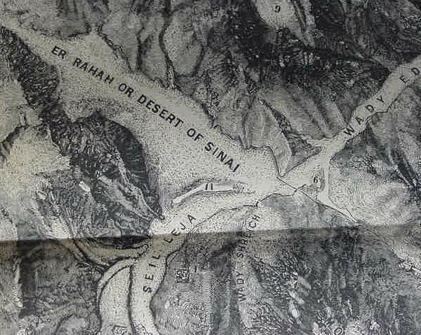
26 May 2006 Update:
Below, a map of Ras Sufsafeh, believed to be Mount Sinai (the Greek Septuaginta's Mt. Sena) by some scholars. Note Jebel Suna on the north side of the plain of er Raha. Could Suna preserve the Septuaginta's Sina? Many scholars have suggested Israel camped on this plain. No archaeological evidence has been found of pottery debris (or tombs of the fallen who were slaughtered for worshipping the Golden Calf) of the Late Bronze Age (ca. 1540-1200 B.C.) or Iron Age I (ca. 1200-1100 B.C.) anywhere in this vicinity. HOWEVER, pottery debris and remains of a settlement from the New Stone Age or Neolithic era has been found on the plain of er Raha. Note a peculiar banana-like outline occurs west of the word "Desert of Sinai" and east the word "Seil Leju." This banana-like outline demarks "an elevation" which is not subject to flashflooding by the Seil Leju which gathers floodwaters descending the slopes of Gebel Musa and Ras Sufsafeh, depositing them into the plain of er Raha. Israel was supposed to have camped for one year at Mount Sinai. If she camped in the plain of er Raha, the SAFEST place to camp would be this banana-like elevation! In 1990-1991 while building a tourist hotel (Daniella Village Hotel) for pilgrims, the remains of the Neolithic settlement (ca. 4500-3300 B.C.) were unearthed on this rise (cf. p. 306. Joseph J. Hobbs. Mount Sinai. Austin. University of Texas Press. 1995). It is however much too early to be Israel's encampment. Other ruins are much later in this area of the Romano-Byzantine and later eras. (For the below map cf. p. 636. "Ordnance Survey Map." William Smith. A Dictionary of the Bible. 1884.reprinted 1948, 1967, 1976. Zondervan Publishing House. Grand Rapids, Michigan).
According to E. H. Palmer (1872, The Desert of the Exodus) who explored this area, the Israelites' approach to the plain of er Raha must be via Wady es Sheikh which empties into Wady ed Deir, as it is wide enough to accomodate a large host. The other access point is via Nagb Hawa to the west of Gebel Suna (the below map shows this route as a double dotted line above the words "Er Raha or Desert of Sinai"). However this "shortcut" is very narrow and steep (an 8 kilometer ascent from Nagb Hawa to the plain of er Raha), and navigable by only a "small group" traveling very lightly (Palmer used both routes). So, if Palmer is correct, Israel approached the plain of er Raha from Wadi Feiran via the Watiyeh Pass, Wady es Sheikh and Wady ed Deir.
The below map shows a Jebel Suna on the north side of the plain of er-Rahah where several 19th century biblical scholars though Israel encamped under Moses. As noted earlier, Professor Menashe har-El has argued that Arabic suna means "law" if he is "right" is the below Jebel Suna the "Mountain of the Law"? That is to say Mount Sinai is not on the southside of the plain of er-Raha it is on the northsdie of the plain? For the below map cf. p. 636. "Ordnance Survey Map." William Smith. A Dictionary of the Bible. 1884.reprinted 1948, 1967, 1976. Zondervan Publishing House. Grand Rapids, Michigan.